Cobb Peak (Idaho)
| Cobb Peak | |
|---|---|
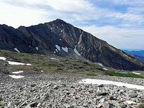 Cobb Peak from the north | |
| Highest point | |
| Elevation | 11,650 ft (3,550 m) [1] |
| Prominence | 650 ft (200 m) [1] |
| Coordinates | 43°43′52″N 114°07′35″W / 43.7310187°N 114.1264312°WCoordinates: 43°43′52″N 114°07′35″W / 43.7310187°N 114.1264312°W [2] |
| Geography | |
 Cobb Peak Blaine County, Idaho, U.S. | |
| Parent range | Pioneer Mountains |
| Topo map | USGS Hyndman Peak |
| Climbing | |
| Easiest route | Scramble, class 3 |
Cobb Peak, at 11,650 feet (3,550 m) above sea level is the 12th highest peak in the Pioneer Mountains of Idaho. The peak is located in Sawtooth National Forest and Blaine County. It is the 35th highest peak in Idaho. Cobb Peak is 1.3 mi (2.1 km) south of Hyndman Peak and 0.8 mi (1.3 km) southwest of Old Hyndman Peak.[3][4][5]
References
- 1 2 "Cobb Peak, Idaho". Peakbagger.com. Retrieved January 1, 2013.
- ↑ "Cobb Peak". Geographic Names Information System. United States Geological Survey. Retrieved January 1, 2013.
- ↑ "The 100 Highest Peaks". Idaho: A Climbing Guide. Retrieved January 1, 2013.
- ↑ Sawtooth National Forest (Map) (1998 ed.). Sawtooth National Forest, U.S. Forest Service.
- ↑ "Cobb Peak". SummitPost.org. Retrieved January 1, 2013.
This article is issued from
Wikipedia.
The text is licensed under Creative Commons - Attribution - Sharealike.
Additional terms may apply for the media files.