Daang Hari Road
| |
|---|---|
| Las Piñas–Muntinlupa–Cavite Road | |
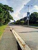
 Daang Hari Road, looking north towards Madrigal Business Park along the Las Piñas - Muntinlupa border | |
| Route information | |
| Maintained by City of Las Piñas, City of Bacoor, and City of Imus | |
| Length | 15.1 km (9.4 mi) |
| Existed | 2003 – present |
| Mainline | |
| From | Commerce Avenue and Investment Drive in Las Piñas - Muntinlupa boundary |
| Major junctions |
|
| To |
|
| Extension | |
| From |
|
| To | Open Canal Road in General Trias |
| Highway system | |
|
Roads in the Philippines | |

The Daang Hari (lit. King's Road) (also known as the Las Piñas–Muntinlupa–Cavite Road or LAMUCAR),[1] is a major arterial thoroughfare that links southern Metro Manila with the province of Cavite in the Philippines. It begins as a north-south road from Commerce Avenue just south of Alabang–Zapote Road running for 5.9 kilometers (3.7 miles) through the borders of Las Piñas and Muntinlupa. It then runs east-west for 9.2 kilometers (5.7 miles) from the intersection with Daang Reyna Road, winding through the cities of Bacoor and Imus in Cavite where it ends at Aguinaldo Highway near Dasmariñas. It was built in 2003 to decongest traffic in the south metropolis, particularly along Alabang–Zapote Road.
Route description
Most of the section known as Daang Hari is a four-lane median divided highway. It is split into two sections by Daang Reyna Road at the boundary of Las Piñas, Muntinlupa and Bacoor.
A spur road, named Daang Reyna, leads to some gated communities, Muntinlupa and San Pedro, Laguna via Magsaysay Road. The spur is mostly a two-lane divided road.
Daang Hari is in the honor to Vista land owner, Former Senator Manuel Villar, Jr.
Commerce Avenue to Daang Reyna
Daang Hari's northern terminus is at the junction with Commerce Avenue in Madrigal Business Park near Alabang Town Center where it is a continuation of the short Investment Drive from Alabang–Zapote Road. The road forms the border between Barangay Ayala Alabang and Poblacion of Muntinlupa to the east and Barangay Almanza of Las Piñas to the west. The road passes the following villages from north to south: T.S. Cruz Subdivision, Ayala Alabang, Ayala Southvale, Versailles, Katarungan Village and Portofino Heights before coming to a roundabout with Daang Reyna and MCX in Evia.
Daang Reyna to Aguinaldo Highway
From the Daang Reyna junction, the road curves sharply to the west and traverses the Molino villages of Bacoor including, from east to west, Verdana Homes, Malipay and Springville South. It intersects with Molino Road / Molino-Paliparan Road where SM Center Molino is located. A few hundred meters west of Molino Road, Daang Hari enters Imus passing through Barangay Pasong Buaya before terminating at the intersection with Aguinaldo Highway in Anabu near the boundary with Salitran, Dasmariñas where The District mall is located. A flyover is under construction to divert through traffic on the existing intersection with Aguinaldo Highway. [2]
Open Canal Road
Daang Hari includes an extension to General Trias named Open Canal Road, also named Daang Hari Extension. The original road existed as an access road for irrigation canals maintained by the National Irrigation Authority (NIA). The road passes Lancaster New City Cavite and other nearby subdivisions and some paddy fields before ending at Arnaldo Highway in barangay Pasong Camachile. Open Canal Road runs as a minor local road up to Governor Ferrer Drive.
Daang Reyna to Magsaysay Road
Daang Reyna, or Vista Avenue, is a 2 kilometres (1.2 mi) spur of Daang Hari, starting from the Daang Hari - MCX interchange near Evia, and this is in honor to Sen. Cynthia Villar. It spur off Daang Hari at the roundabout near MCX and continues south towards another roundabout with Victoria Avenue, which leads to Muntinlupa and ends in Magsaysay Road in San Pedro City, Laguna. The road lies near the Muntinlupa - Las Piñas boundary and passes near gated communities like Portofino South and Amore at Portofino, owned by Vista Land.
Daang Hari-SLEX Link Road
A 4-kilometer extension of Daang Hari Road is now being built that will connect it to South Luzon Expressway (SLEX) in Muntinlupa near San Pedro, Laguna. The toll road, the first Public Private Partnership (PPP) project under the administration of President Benigno Aquino III with Ayala Corporation, will run from the junction with Daang Reyna east towards the Susana Heights interchange of SLEX traversing the New Bilibid Prison (NBP) Reservation in Muntinlupa.[3] It is expected to be completed by September 2014.[4]
The toll road, now known as the Muntinlupa-Cavite Expressway, was opened to traffic on 24 July 2015.
Intersections
Mainline
| Region | Province | City/Municipality | km | mi | Destinations | Notes | ||
|---|---|---|---|---|---|---|---|---|
| Metro Manila | Muntinlupa - Las Piñas boundary | Commerce Avenue/Investment Drive | Northern terminus. Continues northward as Investment Drive. | |||||
| Daang Reyna, | Roundabout. | |||||||
| Calabarzon | Cavite | Bacoor | Molino Boulevard | |||||
| Imus | Daang Hari Extension | |||||||
| Cavite–Laguna Expressway | ||||||||
| General Trias | Arnaldo Highway | Western terminus. Continuation to General Trias as Open Canal Road towards all Zones of Lancaster New City Cavite | ||||||
| 1.000 mi = 1.609 km; 1.000 km = 0.621 mi | ||||||||
Spur
The entire route is located in Las Piñas.
| km | mi | Destinations | Notes |
|---|---|---|---|
| Daang Hari/ | Roundabout. Northern Terminus. | ||
| Victoria Avenue | Roundabout. Southern Terminus. | ||
| 1.000 mi = 1.609 km; 1.000 km = 0.621 mi | |||
References
- ↑ Villar leads inauguration of southern link road published by the Philippine Star; accessed 2013-12-19.
- ↑ "Infrastructure Projects - Region IV-A". Retrieved July 30, 2018.
4A0315H00094 a) Construction/Repair/Rehabilitation/Improvement of Various Infrastructure including Local Projects - Widening/Improvement of Daang Hari Road, Aguinaldo Highway (R1 Expressway), Extension Link Road (Imus-Kawit), Cavite Province including RROW, Phase IV GRAV / Districtwide-1st Congressional District,Cavite District Engineering Office,Region IV-A b) KAMAGONG BUILDERS & DEVELOPERS CORP. c) Cavite District Engineering Office,Region IV-A d) VILP
line feed character in|quote=at position 13 (help) - ↑ Daang Hari-SLEX Link Road Project published by the Public-Private Partnership Center of the Philippines; accessed 2013-12-19.
- ↑ Daang Hari-SLEx road complete by Sept 2014 published by Rappler; accessed 2013-12-19.
| Expressways |
| ||||||||
|---|---|---|---|---|---|---|---|---|---|
| National roads |
| ||||||||
| Arterial Routes |
| ||||||||
Coordinates: 14°23′9″N 120°58′40″E / 14.38583°N 120.97778°E