List of counties in California
| Counties of California | |
|---|---|
| Location | State of California |
| Created | 1850 (27 original counties) |
| Number | 58 counties |
| Populations |
Minimum: Alpine, 1,110 Maximum: Los Angeles, 10,170,292 |
| Areas |
Minimum: San Francisco, 47 square miles (120 km2) Maximum: San Bernardino, 20,062 square miles (51,960 km2) |
| Government | Local government in California |
| Subdivisions | Charter cities |
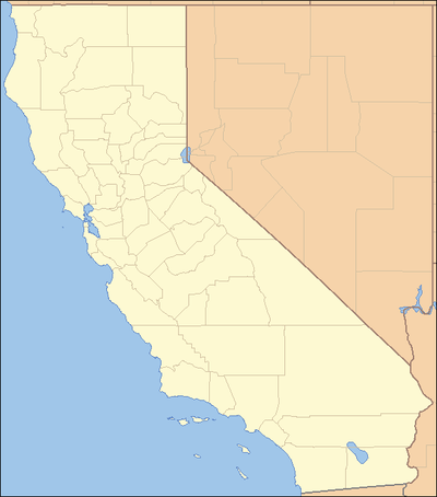
The U.S. state of California is divided into 58 counties.[1] The region was first divided into twenty-seven counties on February 18, 1850. These were further sub-divided to form sixteen additional counties by 1860. Another fourteen were counties formed through further sub-division from 1861 to 1893. The last, Imperial County, was formed in 1907. California is home to San Bernardino County, the largest county in the contiguous United States, as well as Los Angeles County, the most populous county in the United States. The most recent county to form was Imperial County, in 1907.
California counties are general law counties by default, but may be chartered as provided in Article XI, Section 3 of the California Constitution.[2] A charter county is granted considerably more home rule authority than a general law county. Of the 58 counties in California, 14 are governed under a charter. They are Alameda, Butte, El Dorado, Fresno, Los Angeles, Orange, Placer, Sacramento, San Bernardino, San Diego, San Francisco, San Mateo, Santa Clara, and Tehama.[3]
More counties in California are named for saints than in any other state.[4]
List
| County |
FIPS code[5] | County seat[6] | Established[6] | Formed from | Etymology[7] | General Law or Charter [8] |
Population[9] | Area[6] | Map |
|---|---|---|---|---|---|---|---|---|---|
| Alameda County | 001 | Oakland | 1853 | Contra Costa and Santa Clara | The oak and other trees, once abundant in the region; alameda is Spanish for "avenue shaded by trees" or "cottonwood grove". | Charter | 1,663,190 | 738 sq mi (1,911 km2) | 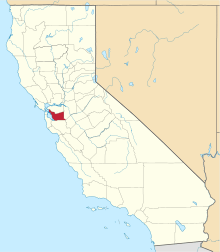 |
| Alpine County | 003 | Markleeville | 1864 | Amador, El Dorado, Calaveras, Mono and Tuolumne | Location high in the Sierra Nevada; alpine refers to the Alps or other mountains. | General Law | 1,120 | 739 sq mi (1,914 km2) | 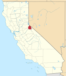 |
| Amador County | 005 | Jackson | 1854 | Calaveras | Jose Maria Amador (1794–1883), a soldier, rancher, and miner who, along with several Native Americans, established a successful gold mining camp near present-day Amador City in 1848. | General Law | 38,626 | 606 sq mi (1,570 km2) | 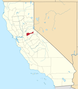 |
| Butte County | 007 | Oroville | 1850 | original | Sutter Buttes, which were mistakenly thought to be in the county at the time of its establishment. | Charter | 229,294 | 1,640 sq mi (4,248 km2) | 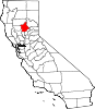 |
| Calaveras County | 009 | San Andreas | 1850 | original | Calaveras River; calaveras is Spanish for "skulls". | General Law | 45,670 | 1,020 sq mi (2,642 km2) | 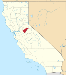 |
| Colusa County | 011 | Colusa | 1850 | original | Rancho Colus land grant from Mexico. | General Law | 21,805 | 1,151 sq mi (2,981 km2) | 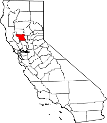 |
| Contra Costa County | 013 | Martinez | 1850 | original | Location across San Francisco Bay from San Francisco; contra costa is Spanish for "opposite coast". | General Law | 1,147,439 | 720 sq mi (1,865 km2) | 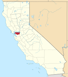 |
| Del Norte County | 015 | Crescent City | 1857 | Klamath | Location along California's northern border; del norte is Spanish for "northern". | General Law | 27,470 | 1,008 sq mi (2,611 km2) |  |
| El Dorado County | 017 | Placerville | 1850 | original | El Dorado, a mythical city of gold, owing to the area's significance in the California Gold Rush. | Charter | 188,987 | 1,712 sq mi (4,434 km2) | 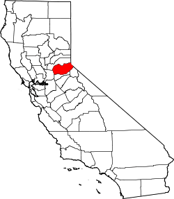 |
| Fresno County | 019 | Fresno | 1856 | Mariposa, Merced and Tulare | The city of Fresno; fresno is Spanish for "ash tree". | Charter | 989,255 | 5,963 sq mi (15,444 km2) | 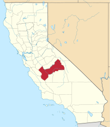 |
| Glenn County | 021 | Willows | 1891 | Colusa | Dr. Hugh J. Glenn, a California businessman and politician. | General Law | 28,094 | 1,315 sq mi (3,406 km2) |  |
| Humboldt County | 023 | Eureka | 1853 | Trinity | Alexander von Humboldt, a German naturalist and explorer. | General Law | 136,754 | 3,573 sq mi (9,254 km2) | 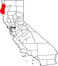 |
| Imperial County | 025 | El Centro | 1907 | San Diego | Imperial Valley, named after the Imperial Land Company. | General Law | 182,830 | 4,175 sq mi (10,813 km2) | 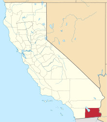 |
| Inyo County | 027 | Independence | 1866 | Mono and Tulare | Exact etymology disputed; early settlers believed Inyo to be the native name for area mountains, but it may be the name of a Mono Indian leader. | General Law | 18,026 | 10,192 sq mi (26,397 km2) | 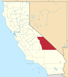 |
| Kern County | 029 | Bakersfield | 1866 | Los Angeles and Tulare | Edward Kern, cartographer for John C. Fremont's 1845 expedition. | General Law | 893,119 | 8,142 sq mi (21,088 km2) |  |
| Kings County | 031 | Hanford | 1893 | Tulare | Kings River; original Spanish name Rio de los Santos Reyes ("River of the Holy Kings"). | General Law | 150,101 | 1,390 sq mi (3,600 km2) | 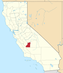 |
| Lake County | 033 | Lakeport | 1861 | Napa | Clear Lake. | General Law | 64,246 | 1,258 sq mi (3,258 km2) |  |
| Lassen County | 035 | Susanville | 1864 | Plumas and Shasta, and now defunct Lake County, Nevada | Peter Lassen, a Danish naturalist and explorer. | General Law | 31,163 | 4,558 sq mi (11,805 km2) | 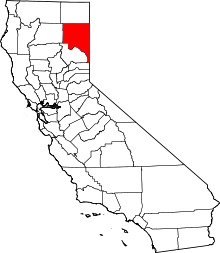 |
| Los Angeles County | 037 | Los Angeles | 1850 | original | The city of Los Angeles, derived from the original Spanish name El Pueblo de Nuestra Señora la Reina de los Angeles del Río de Porciúncula ("The Village of Our Lady, the Queen of the Angels of the River of Porziuncola"). | Charter | 10,163,507 | 4,060 sq mi (10,515 km2) | 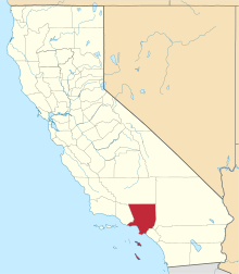 |
| Madera County | 039 | Madera | 1893 | Mariposa | The city of Madera, which was named for the forested landscape; madera is Spanish for "wood". | General Law | 156,890 | 2,138 sq mi (5,537 km2) | 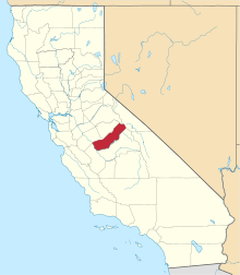 |
| Marin County | 041 | San Rafael | 1850 | original | Exact etymology disputed; probably a corrupted abbreviation of Bahía de Nuestra Señora del Rosario la Marina, the Spanish name for area headlands along San Francisco Bay. | General Law | 260,955 | 520 sq mi (1,347 km2) |  |
| Mariposa County | 043 | Mariposa | 1850 | original | The city of Mariposa; mariposa is Spanish for "butterfly". | General Law | 17,569 | 1,451 sq mi (3,758 km2) | 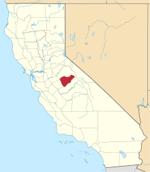 |
| Mendocino County | 045 | Ukiah | 1850 | original | Antonio de Mendoza, first viceroy of New Spain. | General Law | 88,018 | 3,509 sq mi (9,088 km2) | 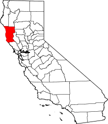 |
| Merced County | 047 | Merced | 1855 | Mariposa | The city of Merced, derived from the original Spanish name El Río de Nuestra Señora de la Merced ("River of Our Lady of Mercy"). | General Law | 272,673 | 1,929 sq mi (4,996 km2) | 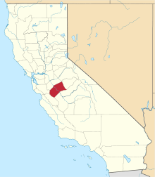 |
| Modoc County | 049 | Alturas | 1874 | Siskiyou | The Modoc people. | General Law | 8,859 | 3,944 sq mi (10,215 km2) | 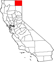 |
| Mono County | 051 | Bridgeport | 1861 | Calaveras, Fresno and Mariposa | Mono Lake; derived from Monachi, a Yokut name for native peoples of the Sierra Nevada. | General Law | 14,168 | 3,044 sq mi (7,884 km2) | 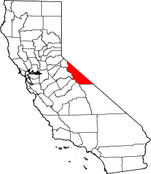 |
| Monterey County | 053 | Salinas | 1850 | original | Derived from Monterey Bay, which was named for a Viceroy of New Spain, Gaspar de Zúñiga, 5th Count of Monterrey. | General Law | 437,907 | 3,322 sq mi (8,604 km2) | 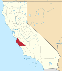 |
| Napa County | 055 | Napa | 1850 | original | Disputed origin; possibly derived from the Patwin word napo, meaning "home". | General Law | 140,973 | 754 sq mi (1,953 km2) |  |
| Nevada County | 057 | Nevada City | 1851 | Yuba | The phrase Sierra Nevada; nevada is Spanish for "snow-covered," referencing the area's high elevation. The neighboring state was named after the county, which was named after Nevada City. | General Law | 99,814 | 958 sq mi (2,481 km2) | 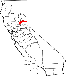 |
| Orange County | 059 | Santa Ana | 1889 | Los Angeles | Oranges, which were widely cultivated in the area at the time the county was established. | Charter | 3,190,400 | 948 sq mi (2,455 km2) | 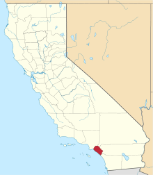 |
| Placer County | 061 | Auburn | 1851 | Sacramento | California Gold Rush, a reference to the area being a center of the California Gold Rush. | Charter | 386,166 | 1,407 sq mi (3,644 km2) | 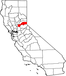 |
| Plumas County | 063 | Quincy | 1854 | Butte | The Feather River; plumas is Spanish for "feathers". | General Law | 18,742 | 2,554 sq mi (6,615 km2) | 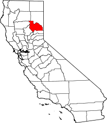 |
| Riverside County | 065 | Riverside | 1893 | San Bernardino and San Diego | The city of Riverside, named for its location on the Santa Ana River. | General Law | 2,423,266 | 7,208 sq mi (18,669 km2) | 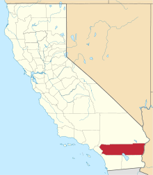 |
| Sacramento County | 067 | Sacramento | 1850 | original | The city of Sacramento, named after the Santisimo Sacramento (Spanish for "Most Holy Sacrament"). | Charter | 1,530,615 | 966 sq mi (2,502 km2) | 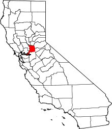 |
| San Benito County | 069 | Hollister | 1874 | Monterey | Saint Benedict (Benito is a Spanish diminutive of Benedict). | General Law | 60,310 | 1,389 sq mi (3,597 km2) | 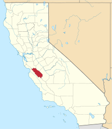 |
| San Bernardino County | 071 | San Bernardino | 1853 | Los Angeles | The city of San Bernardino, named after Saint Bernardino of Siena (Spanish for Saint Bernardine). | Charter | 2,157,404 | 20,062 sq mi (51,960 km2) | 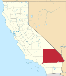 |
| San Diego County | 073 | San Diego | 1850 | original | The city of San Diego, from Mission San Diego (Spanish for Saint Didacus). | Charter | 3,337,685 | 4,204 sq mi (10,888 km2) | 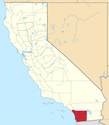 |
| San Francisco | 075 | San Francisco | 1850 | original | The city of San Francisco, from Presidio of San Francisco and Mission San Francisco de Asís, named after Saint Francis of Assisi (Spanish for Saint Francis). | Charter | 884,363 | 47 sq mi (122 km2) |  |
| San Joaquin County | 077 | Stockton | 1850 | original | Spanish for Saint Joachim, father of the Virgin Mary. | General Law | 745,424 | 1,399 sq mi (3,623 km2) | 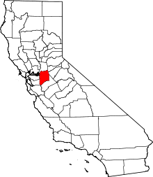 |
| San Luis Obispo County | 079 | San Luis Obispo | 1850 | original | The city of San Luis Obispo, from Mission San Luis Obispo, named after Saint Louis of Toulouse (Spanish for Saint Louis, the Bishop). | General Law | 283,405 | 3,304 sq mi (8,557 km2) | 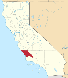 |
| San Mateo County | 081 | Redwood City | 1856 | San Francisco and Santa Cruz | Spanish for Saint Matthew. | Charter | 771,410 | 449 sq mi (1,163 km2) | 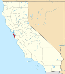 |
| Santa Barbara County | 083 | Santa Barbara | 1850 | original | The city of Santa Barbara, from Mission Santa Barbara, (Spanish for Saint Barbara). | General Law | 448,150 | 2,738 sq mi (7,091 km2) | 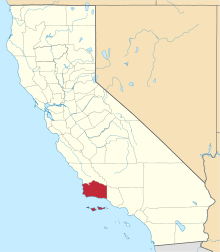 |
| Santa Clara County | 085 | San Jose | 1850 | original | City of Santa Clara, from Mission Santa Clara de Asís, named for Saint Clare of Assisi (Spanish for Saint Clare). | Charter | 1,938,153 | 1,291 sq mi (3,344 km2) | 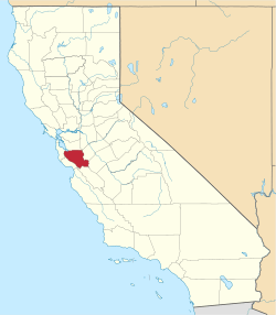 |
| Santa Cruz County | 087 | Santa Cruz | 1850 | original | The city of Santa Cruz, from Mission Santa Cruz (Spanish for "holy cross"). | General Law | 275,897 | 446 sq mi (1,155 km2) | 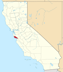 |
| Shasta County | 089 | Redding | 1850 | original | Mount Shasta; the indigenous Shasta people. | General Law | 179,921 | 3,786 sq mi (9,806 km2) | 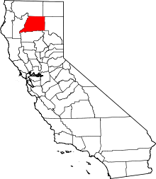 |
| Sierra County | 091 | Downieville | 1852 | Yuba | Sierra is Spanish for "mountain range", a reference to the area's topography. | General Law | 2,999 | 953 sq mi (2,468 km2) | 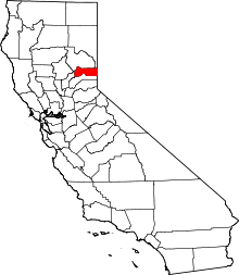 |
| Siskiyou County | 093 | Yreka | 1852 | Shasta and Klamath | Siskiyou Mountains; exact etymology of Siskiyou is disputed. | General Law | 43,853 | 6,287 sq mi (16,283 km2) | 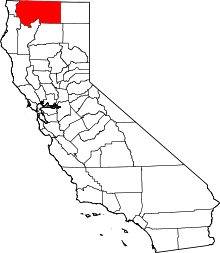 |
| Solano County | 095 | Fairfield | 1850 | original | Chief Solano of the Suisunes. | General Law | 445,458 | 828 sq mi (2,145 km2) | 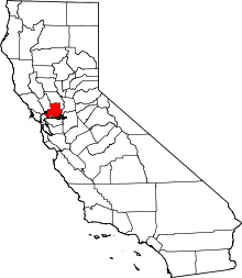 |
| Sonoma County | 097 | Santa Rosa | 1850 | original | Exact etymology disputed; probably a Pomo term meaning "valley of the moon," which references a native legend about spiritual activity in the area. | General Law | 504,217 | 1,576 sq mi (4,082 km2) | 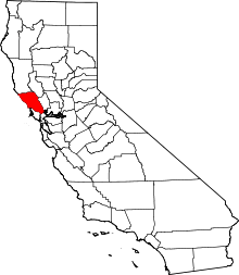 |
| Stanislaus County | 099 | Modesto | 1854 | Tuolumne | Stanislaus River, named after Estanislao, a native of the area when California was under Spanish and Mexican rule. | General Law | 547,899 | 1,495 sq mi (3,872 km2) | 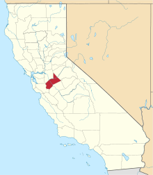 |
| Sutter County | 101 | Yuba City | 1850 | original | John Sutter, a Swiss pioneer of California associated with the California Gold Rush. | General Law | 96,648 | 603 sq mi (1,562 km2) |  |
| Tehama County | 103 | Red Bluff | 1856 | Butte, Colusa and Shasta | The city of Tehama, probably a native term describing its location. | Charter | 63,926 | 2,951 sq mi (7,643 km2) | 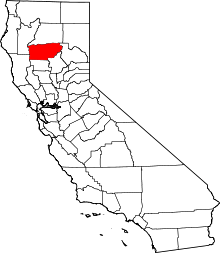 |
| Trinity County | 105 | Weaverville | 1850 | original | The city of Trinidad, Spanish for "trinity". | General Law | 12,709 | 3,179 sq mi (8,234 km2) | 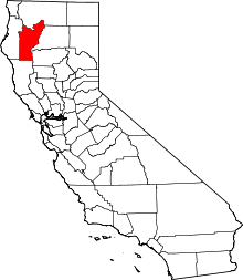 |
| Tulare County | 107 | Visalia | 1852 | Mariposa | Tulare Lake, which is named after the tule rush (Schoenoplectus acutus) that grew in the marshes and sloughs along its shores. | General Law | 464,493 | 4,824 sq mi (12,494 km2) | 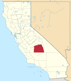 |
| Tuolumne County | 109 | Sonora | 1850 | original | Exact etymology disputed; probably a corruption of the native term talmalamne, which means "cluster of stone wigwams," a reference to local cave dwelling tribes. | General Law | 54,248 | 2,236 sq mi (5,791 km2) | 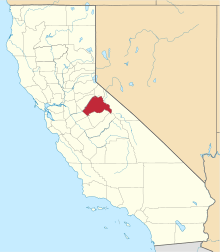 |
| Ventura County | 111 | Ventura | 1872 | Santa Barbara | The city of Ventura, derived from Mission San Buenaventura (Spanish for St. Bonaventure). | General Law | 854,223 | 1,846 sq mi (4,781 km2) | 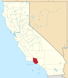 |
| Yolo County | 113 | Woodland | 1850 | original | The Yolan people, a local Native American tribe. | General Law | 219,116 | 1,012 sq mi (2,621 km2) |  |
| Yuba County | 115 | Marysville | 1850 | original | Named either by the Maidu people, a local Native American tribe who live on the banks of the Feather and Yuba Rivers, for one of their villages, or by Gabriel Moraga for the wild grapes (Vitis californica) that grow abundantly at the edge of the rivers (uva is Spanish for "grape"). | General Law | 77,031 | 630 sq mi (1,632 km2) |  |
Defunct counties
- Klamath County was created in 1851 from the northern half of Trinity County. Part of the county's territory went to Del Norte County in 1857, and in 1874 the remainder was divided between Humboldt and Siskiyou counties.
- Pautah County was created in 1852 out of territory which, the state of California assumed, was to be ceded to it by the United States Congress from territory in what is now the state of Nevada. When the cession never occurred, the California State Legislature officially abolished the never-organized county in 1859.
- Buena Vista County was created in 1855 by the California State Legislature out of the southeastern territory of Tulare County on the west of the Sierra Nevada but was never officially organized. The south of Tulare County was later organized as Kern County in 1866, with additions from Los Angeles and San Bernardino counties.
- Coso County was created in 1864 by the California State Legislature out of territory of Mono County and Tulare County on the east slope of the Sierra Nevada but was never officially organized. The region was later organized in 1866 as Inyo County with additions from Los Angeles and San Bernardino counties.
Notes
- ↑ "Find A County". National Association of Counties. Archived from the original on 2014-01-13. Retrieved 2012-04-07.
- ↑ "California Constitution, ARTICLE XI LOCAL GOVERNMENT [SEC. 1 - SEC. 15] SEC. 3". leginfo.legislature.ca.gov. State of California. June 2, 1970. Retrieved May 10, 2018.
- ↑ "County Structure & Powers". www.counties.org. California State Association of Counties. Retrieved May 10, 2018.
- ↑ Kane, Joseph Nathan; Aiken, Charles Curry (2005). The American Counties: Origins of County Names, Dates of Creation, and Population Data, 1950-2000. Scarecrow Press. p. 11. ISBN 978-0-8108-5036-1.
- ↑ "EPA County FIPS Code Listing". EPA.gov. Retrieved February 23, 2008.
- 1 2 3 National Association of Counties. "NACo - Find a county". Archived from the original on June 5, 2008. Retrieved April 30, 2008.
- ↑ Sanchez, Nellie Van de Grift (1914). Spanish and Indian Place Names of California: Their Meaning and Their Romance. San Francisco: A. M. Robertson. OCLC 4268886.
- ↑ "County Structure & Powers". www.counties.org. California State Association of Counties. Retrieved May 10, 2018.
- ↑ "Annual Estimates of the Resident Population: April 1, 2010 to July 1, 2017". United States Census Bureau. Retrieved April 6, 2018.
External links
- California State Association of Counties
- State map showing the county names and linking to county data
- California State Association of Counties- The Creation of Our 58 Counties, with Maps of the 58 Counties Each Decade ca.1850–1900
- California State Association of Counties, Map of California Counties: c. 1907-Present
