Châteauneuf-sur-Loire
| Châteauneuf-sur-Loire | ||
|---|---|---|
| Commune | ||
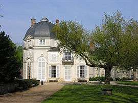 The château, which contains the town hall | ||
| ||
 Châteauneuf-sur-Loire Location within Centre-Val de Loire region  Châteauneuf-sur-Loire | ||
| Coordinates: 47°51′58″N 2°13′23″E / 47.8661°N 2.2231°ECoordinates: 47°51′58″N 2°13′23″E / 47.8661°N 2.2231°E | ||
| Country | France | |
| Region | Centre-Val de Loire | |
| Department | Loiret | |
| Arrondissement | Orléans | |
| Canton | Châteauneuf-sur-Loire | |
| Government | ||
| • Mayor (2008–2014) | Loïs Lamoine | |
| Area1 | 40.01 km2 (15.45 sq mi) | |
| Population (2012)2 | 7,926 | |
| • Density | 200/km2 (510/sq mi) | |
| Demonym(s) | Castelneuviens | |
| Time zone | UTC+1 (CET) | |
| • Summer (DST) | UTC+2 (CEST) | |
| INSEE/Postal code | 45082 /45110 | |
| Elevation | 100–131 m (328–430 ft) | |
| Website | www.chateauneuf-sur-loire.com | |
|
1 French Land Register data, which excludes lakes, ponds, glaciers > 1 km2 (0.386 sq mi or 247 acres) and river estuaries. 2 Population without double counting: residents of multiple communes (e.g., students and military personnel) only counted once. | ||

Châteauneuf-sur-Loire is a commune in the Loiret department in north-central France.
Twin towns

See also
| Wikimedia Commons has media related to Châteauneuf-sur-Loire. |
This article is issued from
Wikipedia.
The text is licensed under Creative Commons - Attribution - Sharealike.
Additional terms may apply for the media files.