East Rockhill Township, Bucks County, Pennsylvania
| East Rockhill Township | |
|---|---|
| Township | |
 | |
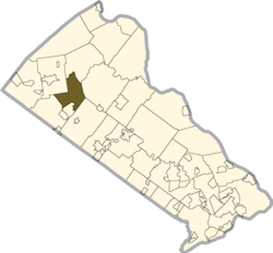 Location of East Rockhill Township in Bucks County | |
 East Rockhill Township Location in Pennsylvania and the United States  East Rockhill Township East Rockhill Township (the US) | |
| Coordinates: 40°26′18″N 75°16′16″W / 40.43833°N 75.27111°WCoordinates: 40°26′18″N 75°16′16″W / 40.43833°N 75.27111°W | |
| Country | United States |
| State | Pennsylvania |
| County | Bucks |
| Area[1] | |
| • Total | 13.09 sq mi (33.90 km2) |
| • Land | 12.91 sq mi (33.44 km2) |
| • Water | 0.18 sq mi (0.46 km2) |
| Elevation | 446 ft (136 m) |
| Population (2010) | |
| • Total | 5,706 |
| • Estimate (2016)[2] | 5,730 |
| • Density | 443.81/sq mi (171.35/km2) |
| Time zone | UTC-5 (EST) |
| • Summer (DST) | UTC-4 (EDT) |
| Area code(s) | 215 |
| FIPS code | 42-017-21760 |
East Rockhill Township is a township in Bucks County, Pennsylvania, United States. The original Rockhill Township was established in 1740 and was divided into East and West Rockhill Townships in 1890. The population was 5,706 at the 2010 Census. East Rockhill is part of Pennridge School District. Pennridge Airport is located in East Rockhill Township.
History
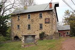
The Levi Sheard Mill and Sheard's Mill Covered Bridge are listed on the National Register of Historic Places.[3] It was also the location of the formerly listed Mood's Covered Bridge.
Geography
According to the United States Census Bureau, the township has a total area of 13.1 square miles (34 km2), of which, 12.9 square miles (33 km2) of it is land and 0.2 square miles (0.52 km2) of it (1.14%) is water. Tohickon Creek flows along the northern edge of the township into Lake Nockamixon at its northeast edge and eastward into the Delaware River and drains most of East Rockhill. The southeast side of the township is drained by the East Branch Perkiomen Creek into the Perkiomen Creek and Schuylkill River.
East Rockhill's villages include Hagersville, Rich Hill, Rockhill, Rockhill Station, Rock Ridge, Smoketown (also in West Rockhill), Sterners Mill, Weisel, and White Horse.[4]
Natural features include East Branch of the Perkiomen Creek, Rock Hill, Three Mile Run, and Tohickon Creek.[4]
Adjacent municipalities
- West Rockhill Township (west)
- Richland Township (northwest)
- Haycock Township (north)
- Bedminster Township (east)
- Hilltown Township (southeast)
- Perkasie (south)
Demographics
| Historical population | |||
|---|---|---|---|
| Census | Pop. | %± | |
| 1930 | 1,520 | — | |
| 1940 | 1,350 | −11.2% | |
| 1950 | 1,626 | 20.4% | |
| 1960 | 1,990 | 22.4% | |
| 1970 | 2,866 | 44.0% | |
| 1980 | 2,971 | 3.7% | |
| 1990 | 3,753 | 26.3% | |
| 2000 | 5,199 | 38.5% | |
| 2010 | 5,706 | 9.8% | |
| Est. 2016 | 5,730 | [2] | 0.4% |
| [5] | |||
As of the 2010 census, the township was 95.8% White, 0.7% Black or African American, 0.2% Native American, 0.6% Asian, and 1.2% were two or more races. 1.6% of the population were of Hispanic or Latino ancestry.[6]
As of the census[7] of 2000, there were 5,199 people, 1,828 households, and 1,427 families residing in the township. The population density was 401.5 people per square mile (155.0/km²). There were 1,883 housing units at an average density of 145.4/sq mi (56.1/km²). The racial makeup of the township was 97.19% White, 0.81% African American, 0.40% Native American, 0.38% Asian, 0.06% Pacific Islander, 0.19% from other races, and 0.96% from two or more races. Hispanic or Latino of any race were 1.25% of the population.
There were 1,828 households, out of which 40.4% had children under the age of 18 living with them, 68.6% were married couples living together, 5.8% had a female householder with no husband present, and 21.9% were non-families. 17.1% of all households were made up of individuals, and 5.4% had someone living alone who was 65 years of age or older. The average household size was 2.82 and the average family size was 3.21.
In the township the population was spread out, with 28.8% under the age of 18, 6.3% from 18 to 24, 32.5% from 25 to 44, 23.6% from 45 to 64, and 8.9% who were 65 years of age or older. The median age was 36 years. For every 100 females there were 102.1 males. For every 100 females age 18 and over, there were 101.0 males.
The median income for a household in the township was $59,663, and the median income for a family was $70,645. Males had a median income of $43,134 versus $30,473 for females. The per capita income for the township was $24,594. About 2.0% of families and 4.9% of the population were below the poverty line, including 3.0% of those under age 18 and 7.6% of those age 65 or over.
Climate
During the summer months, frequent episodes of high humidity occur. Occasionally, heat index values exceed 100 °F (38 °C). On average, the wettest month of the year is July which corresponds with the annual peak for thunderstorm activity. During the winter months, wind chill values occasionally fall below 0 °F (-18 °C). On average, the snowiest month of the year is February which corresponds with the annual peak for nor'easter activity.
| Climate data for East Rockhill Township, Pennsylvania (1981 – 2010 averages). Elevation 423 ft (129 m). | |||||||||||||
|---|---|---|---|---|---|---|---|---|---|---|---|---|---|
| Month | Jan | Feb | Mar | Apr | May | Jun | Jul | Aug | Sep | Oct | Nov | Dec | Year |
| Average high °F (°C) | 37.8 (3.2) |
41.2 (5.1) |
49.6 (9.8) |
61.8 (16.6) |
71.9 (22.2) |
80.4 (26.9) |
84.3 (29.1) |
82.7 (28.2) |
75.9 (24.4) |
64.4 (18) |
53.4 (11.9) |
41.9 (5.5) |
62.1 (16.7) |
| Average low °F (°C) | 20.5 (−6.4) |
22.5 (−5.3) |
29.4 (−1.4) |
39.1 (3.9) |
48.6 (9.2) |
58.2 (14.6) |
63.0 (17.2) |
61.5 (16.4) |
53.5 (11.9) |
41.9 (5.5) |
33.5 (0.8) |
25.1 (−3.8) |
41.4 (5.2) |
| Average precipitation inches (mm) | 3.50 (88.9) |
2.85 (72.4) |
3.81 (96.8) |
4.11 (104.4) |
4.33 (110) |
4.38 (111.3) |
4.80 (121.9) |
3.90 (99.1) |
4.54 (115.3) |
4.34 (110.2) |
3.76 (95.5) |
4.04 (102.6) |
48.36 (1,228.4) |
| Average snowfall inches (cm) | 9.2 (23.4) |
10.3 (26.2) |
4.4 (11.2) |
0.8 (2) |
0.0 (0) |
0.0 (0) |
0.0 (0) |
0.0 (0) |
0.0 (0) |
0.0 (0) |
0.6 (1.5) |
4.5 (11.4) |
29.8 (75.7) |
| Source: PRISM[8] | |||||||||||||
See also
References
- ↑ "2016 U.S. Gazetteer Files". United States Census Bureau. Retrieved Aug 13, 2017.
- 1 2 "Population and Housing Unit Estimates". Retrieved June 9, 2017.
- ↑ National Park Service (2010-07-09). "National Register Information System". National Register of Historic Places. National Park Service.
- 1 2 MacReynolds, George, Place Names in Bucks County, Pennsylvania, Doylestown, Bucks County Historical Society, Doylestown, PA, 1942, P1.
- ↑ http://www.dvrpc.org/data/databull/rdb/db82/appedixa.xls
- ↑ "Census 2010: Pennsylvania". Usatoday.Com. Retrieved 2013-07-22.
- ↑ "American FactFinder". United States Census Bureau. Archived from the original on 2013-09-11. Retrieved 2008-01-31.
- ↑
