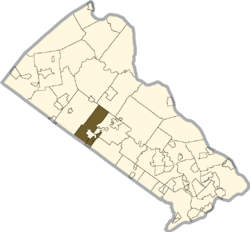
New Britain Township, Bucks County, Pennsylvania
| New Britain Township | |
|---|---|
| Township | |
 | |
 Location of New Britain Township in Bucks County | |
 New Britain Township Location of New Britain Township in Pennsylvania  New Britain Township New Britain Township (the US) | |
| Coordinates: 40°17′55″N 75°10′24″W / 40.29861°N 75.17333°WCoordinates: 40°17′55″N 75°10′24″W / 40.29861°N 75.17333°W | |
| Country | United States |
| State | Pennsylvania |
| County | Bucks |
| Founded | 1723 |
| Government | |
| • Body | Board of Supervisors |
| • Chairman | A. James Scanzillo |
| • Vice Chair | John A. Bodden |
| • Member |
Helen Haun William B. Jones Gregory T. Hood |
| Area[1] | |
| • Total | 15.29 sq mi (39.60 km2) |
| • Land | 14.68 sq mi (38.02 km2) |
| • Water | 0.61 sq mi (1.58 km2) |
| Elevation | 276 ft (84 m) |
| Population (2010) | |
| • Total | 11,070 |
| • Estimate (2016)[2] | 11,199 |
| • Density | 762.93/sq mi (294.57/km2) |
| Time zone | UTC-5 (Eastern (EST)) |
| • Summer (DST) | UTC-4 (EDT) |
| Area code(s) | 215 and 267 |
| FIPS code | 42-017-53304 |
| Website |
www |
New Britain Township is a township in Bucks County, Pennsylvania, United States. The population was 11,070 at the 2010 census.
History
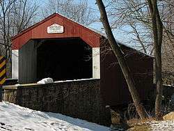
The Morgan James Homestead and Pine Valley Covered Bridge are listed on the National Register of Historic Places.[3]
Geography
According to the United States Census Bureau, the township has a total area of 15.2 square miles (39.5 km²), of which, 14.7 square miles (38.1 km²) of it is land and 0.6 square miles (1.4 km²) of it (3.61%) is water. It is drained by the Delaware River via the Neshaminy Creek. Its villages include Christy (also in Montgomery County,) Fountainville, Line Lexington (also in Hilltown Township and Montgomery County,) Naces Corner, New Galena, and Newville.[4] Brittany Farms-The Highlands CDP is also located in the township.
Natural features include Cooks Run, Iron Hill, Neshaminy Creek, Pine Run, Prospect Hill, and Royal Hill.[4] New Britain Township is home to Peace Valley Park, a county park that surrounds Lake Galena, a reservoir along the North Branch Neshaminy Creek.
Neighboring municipalities
- Hilltown Township (northwest)
- Plumstead Township (northeast)
- Doylestown Township (east)
- New Britain (east)
- Chalfont (east)
- Warrington Township (southeast)
- Montgomery Township, Montgomery County (south)
- Hatfield Township, Montgomery County (southwest)
Demographics
| Historical population | |||
|---|---|---|---|
| Census | Pop. | %± | |
| 1930 | 1,157 | — | |
| 1940 | 1,119 | −3.3% | |
| 1950 | 1,361 | 21.6% | |
| 1960 | 3,090 | 127.0% | |
| 1970 | 5,207 | 68.5% | |
| 1980 | 7,415 | 42.4% | |
| 1990 | 9,099 | 22.7% | |
| 2000 | 10,698 | 17.6% | |
| 2010 | 11,070 | 3.5% | |
| Est. 2016 | 11,199 | [2] | 1.2% |
| [5] | |||
As of the 2010 census, the township was 92.0% White, 1.6% Black or African American, 0.1% Native American, 3.3% Asian, and 0.9% were two or more races. 2.4% of the population were of Hispanic or Latino ancestry.[6]
As of the census[7] of 2000, there were 10,698 people, 3,895 households, and 3,034 families residing in the township. The population density was 727.6 people per square mile (281.0/km²). There were 3,969 housing units at an average density of 270.0/sq mi (104.2/km²). The racial makeup of the township was 96.26% White, 1.35% African American, 0.12% Native American, 1.14% Asian, 0.43% from other races, and 0.70% from two or more races. Hispanic or Latino of any race were 1.28% of the population.
There were 3,895 households, out of which 38.0% had children under the age of 18 living with them, 68.8% were married couples living together, 7.1% had a female householder with no husband present, and 22.1% were non-families. 18.4% of all households were made up of individuals, and 6.6% had someone living alone who was 65 years of age or older. The average household size was 2.74 and the average family size was 3.14.
In the township the population was spread out, with 27.4% under the age of 18, 4.6% from 18 to 24, 29.7% from 25 to 44, 26.5% from 45 to 64, and 11.9% who were 65 years of age or older. The median age was 39 years. For every 100 females there were 95.3 males. For every 100 females age 18 and over, there were 91.3 males.
The median income for a household in the township was $71,194, and the median income for a family was $77,896. Males had a median income of $57,188 versus $34,390 for females. The per capita income for the township was $28,923. About 1.4% of families and 1.9% of the population were below the poverty line, including 2.3% of those under age 18 and 1.7% of those age 65 or over.
References
- ↑ "2016 U.S. Gazetteer Files". United States Census Bureau. Retrieved Aug 13, 2017.
- 1 2 "Population and Housing Unit Estimates". Retrieved June 9, 2017.
- ↑ National Park Service (2010-07-09). "National Register Information System". National Register of Historic Places. National Park Service.
- 1 2 MacReynolds, George, Place Names in Bucks County, Pennsylvania, Doylestown, Bucks County Historical Society, Doylestown, PA, 1942, P1.
- ↑ http://www.dvrpc.org/data/databull/rdb/db82/appedixa.xls
- ↑ "Census 2010: Pennsylvania". Usatoday.Com. Retrieved 2013-07-22.
- ↑ "American FactFinder". United States Census Bureau. Retrieved 2008-01-31.
