Doylestown Township, Bucks County, Pennsylvania
| Doylestown Township | |
|---|---|
| Township | |
 | |
| Motto(s): "A Township with a sense of place"[1] | |
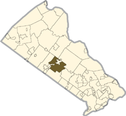 Location of Doylestown Township in Bucks County | |
 Doylestown Township Location in Pennsylvania and the United States  Doylestown Township Doylestown Township (the US) | |
| Coordinates: 40°18′46″N 75°07′37″W / 40.3129°N 75.1270°WCoordinates: 40°18′46″N 75°07′37″W / 40.3129°N 75.1270°W | |
| Country | United States |
| State | Pennsylvania |
| County | Bucks |
| Founded | 1818 |
| Area[2] | |
| • Total | 15.63 sq mi (40.48 km2) |
| • Land | 15.44 sq mi (39.99 km2) |
| • Water | 0.19 sq mi (0.49 km2) |
| Elevation | 299 ft (91 m) |
| Population (2010) | |
| • Total | 17,565 |
| • Estimate (2016)[3] | 17,559 |
| • Density | 1,137.09/sq mi (439.05/km2) |
| Time zone | UTC-5 (EST) |
| • Summer (DST) | UTC-4 (EDT) |
| Area code(s) | 215 |
| FIPS code | 42-017-19792 |
| Website |
www |
Doylestown Township is a township in Bucks County, Pennsylvania, United States. The population was 17,565 at the 2010 census. Adjacent to the county seat, many county offices and the county correctional facility are located in this township. Doylestown Central Park is a park in the township.
History
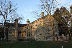
Doylestown includes a number of villages which were formerly independent communities, including Bennetts Corner, Castle Valley, Cross Keys, Dyerstown, Edison, Fountainville, Furlong, Greers Corner, Paul Valley, Tradesville, The Turk, and Vauxtown.[1][4] Fordhook Farm and Tabor Home for Needy and Destitute Children were listed on the National Register of Historic Places in 1987.[5] It was also the location of the formerly listed Fretz Farm.
Geography
According to the United States Census Bureau, the township has a total area of 15.6 square miles (40 km2), of which, 15.5 square miles (40 km2) of it is land and 0.1 square miles (0.26 km2) of it (0.51%) is water. It is drained by the Neshaminy Creek into the Delaware River.
Natural features include Almshouse Hill, Featherbed Hill, Flatiron Hill, Fretz Valley, Iron Hill, Little Buckingham Mountain, Mill Creek, Neshaminy Creek, Pebble Hill, and Pine Run.[4]
Neighboring municipalities
- Warwick Township (southeast)
- Warrington Township (south)
- New Britain (west)
- New Britain Township (northwest)
- Plumstead Township (north)
- Doylestown (north)
- Buckingham Township (northeast)
Demographics
| Historical population | |||
|---|---|---|---|
| Census | Pop. | %± | |
| 1930 | 1,371 | — | |
| 1940 | 1,471 | 7.3% | |
| 1950 | 2,364 | 60.7% | |
| 1960 | 3,795 | 60.5% | |
| 1970 | 6,613 | 74.3% | |
| 1980 | 11,824 | 78.8% | |
| 1990 | 14,510 | 22.7% | |
| 2000 | 17,619 | 21.4% | |
| 2010 | 17,565 | −0.3% | |
| Est. 2016 | 17,559 | [3] | 0.0% |
| [6] | |||
As of the 2010 census, the township was 92.4% White, 1.3% Black or African American, 0.1% Native American, 1.9% Asian, 0.1% Native Hawaiian or other Pacific Islander, and 1.5% were two or more races. 2.8% of the population were of Hispanic or Latino ancestry.[7]
As of the census[8] of 2000, there were 17,619 people, 5,999 households, and 4,445 families residing in the township. The population density was 1,136.7 people per square mile (438.9/km²). There were 6,200 housing units at an average density of 400.0/sq mi (154.4/km²). The racial makeup of the township was 95.22% White, 2.59% African American, 0.06% Native American, 1.25% Asian, 0.02% Pacific Islander, 0.20% from other races, and 0.64% from two or more races. Hispanic or Latino of any race were 1.40% of the population.
There were 5,999 households, out of which 35.1% had children under the age of 18 living with them, 66.7% were married couples living together, 5.6% had a female householder with no husband present, and 25.9% were non-families. 22.0% of all households were made up of individuals, and 11.7% had someone living alone who was 65 years of age or older. The average household size was 2.63 and the average family size was 3.11.
In the township the population was spread out, with 23.7% under the age of 18, 5.4% from 18 to 24, 27.2% from 25 to 44, 25.7% from 45 to 64, and 18.0% who were 65 years of age or older. The median age was 42 years. For every 100 females there were 96.7 males. For every 100 females age 18 and over, there were 94.1 males.
The median income for a household in the township was $81,226, and the median income for a family was $93,984. Males had a median income of $62,853 versus $36,180 for females. The per capita income for the township was $38,031. About 1.6% of families and 3.7% of the population were below the poverty line, including 2.6% of those under age 18 and 4.8% of those age 65 or over.
Climate
During the summer months, frequent episodes of high humidity occur. Occasionally, heat index values exceed 100°F (38°C). On average, the wettest month of the year is July which corresponds with the annual peak for thunderstorm activity. During the winter months, wind chill values occasionally fall below 0°F (-18°C). On average, the snowiest month of the year is February which corresponds with the annual peak for nor'easter activity.
| Climate data for Doylestown Township, Pennsylvania (1981 – 2010 averages). Elevation 296 ft (90 m). | |||||||||||||
|---|---|---|---|---|---|---|---|---|---|---|---|---|---|
| Month | Jan | Feb | Mar | Apr | May | Jun | Jul | Aug | Sep | Oct | Nov | Dec | Year |
| Average high °F (°C) | 39.1 (3.9) |
42.4 (5.8) |
50.7 (10.4) |
62.7 (17.1) |
72.6 (22.6) |
81.4 (27.4) |
85.5 (29.7) |
83.9 (28.8) |
77.0 (25) |
65.7 (18.7) |
54.6 (12.6) |
43.3 (6.3) |
63.2 (17.3) |
| Average low °F (°C) | 21.8 (−5.7) |
24.0 (−4.4) |
30.9 (−0.6) |
40.4 (4.7) |
49.8 (9.9) |
59.5 (15.3) |
64.5 (18.1) |
63.0 (17.2) |
55.3 (12.9) |
43.2 (6.2) |
34.9 (1.6) |
26.4 (−3.1) |
42.8 (6) |
| Average precipitation inches (mm) | 3.24 (82.3) |
2.62 (66.5) |
3.72 (94.5) |
3.90 (99.1) |
4.34 (110.2) |
4.30 (109.2) |
5.01 (127.3) |
4.06 (103.1) |
4.44 (112.8) |
4.18 (106.2) |
3.63 (92.2) |
3.90 (99.1) |
47.34 (1,202.5) |
| Average snowfall inches (cm) | 8.7 (22.1) |
9.7 (24.6) |
4.2 (10.7) |
0.8 (2) |
0.0 (0) |
0.0 (0) |
0.0 (0) |
0.0 (0) |
0.0 (0) |
0.0 (0) |
0.5 (1.3) |
4.3 (10.9) |
28.2 (71.6) |
| Source: PRISM[9] | |||||||||||||
Notable residents
- Władysław Bortnowski, high-ranking Polish general during World War II
- William Godshalk, U.S. Representative
- Anthony Green, singer-songwriter (Circa Survive)
- Annie Haslam, singer-songwriter (Renaissance)
- Irene Molloy, singer and actress
- Alecia Moore (Pink), singer
- Jon Simmons, singer-songwriter (Balance and Composure)
References
- 1 2 "Doylestown Township, Pennsylvania". Doylestown Township, Pennsylvania. Retrieved August 10, 2012.
- ↑ "2016 U.S. Gazetteer Files". United States Census Bureau. Retrieved Aug 13, 2017.
- 1 2 "Population and Housing Unit Estimates". Retrieved June 9, 2017.
- 1 2 MacReynolds, George, Place Names in Bucks County, Pennsylvania, Doylestown, Bucks County Historical Society, Doylestown, PA, 1942.
- ↑ National Park Service (2010-07-09). "National Register Information System". National Register of Historic Places. National Park Service.
- ↑ http://www.dvrpc.org/data/databull/rdb/db82/appedixa.xls
- ↑ "Census 2010: Pennsylvania". Usatoday.Com. Retrieved 2013-07-22.
- ↑ "American FactFinder". United States Census Bureau. Archived from the original on 2013-09-11. Retrieved 2008-01-31.
- ↑ "Data Explorer: Time Series Values for Individual Locations". Northwest Alliance for Computational Science & Engineering. Retrieved 2017-05-23.
