Bridgeton Township, Bucks County, Pennsylvania
| Bridgeton Township, Pennsylvania | |
|---|---|
| Township | |
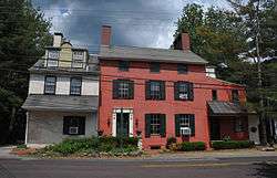 House in Upper Black Eddy | |
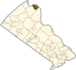 Location of Bridgeton Township in Bucks County | |
 Bridgeton Township Location in Pennsylvania and the United States  Bridgeton Township Bridgeton Township (the US) | |
| Coordinates: 40°33′29″N 75°06′37″W / 40.55806°N 75.11028°WCoordinates: 40°33′29″N 75°06′37″W / 40.55806°N 75.11028°W | |
| Country | United States |
| State | Pennsylvania |
| County | Bucks |
| Area[1] | |
| • Total | 6.80 sq mi (17.62 km2) |
| • Land | 6.58 sq mi (17.05 km2) |
| • Water | 0.22 sq mi (0.57 km2) |
| Elevation | 568 ft (173 m) |
| Population (2010) | |
| • Total | 1,277 |
| • Estimate (2016)[2] | 1,275 |
| • Density | 193.68/sq mi (74.78/km2) |
| Time zone | UTC-5 (EST) |
| • Summer (DST) | UTC-4 (EDT) |
| Area code(s) | 610 |
| FIPS code | 42-017-08592 |
Bridgeton Township is a township in Bucks County, Pennsylvania, United States. The population was 1,277 at the 2010 census. The township was originally a part of adjacent Nockamixon Township, but a division was arranged and signed on May 24, 1890[3]. This accord split an area of Nockamixon which ran west from the banks of the Delaware River to about one third the breadth of the original township. This smaller area was unsurprisingly named "Bridgeton", as it was the site of wooden truss bridge which connected the towns of Upper Black Eddy and Milford, New Jersey. The township originally contained several tiny hamlets, such as the aforementioned Upper Black Eddy, Narrowsville, and Rupletown[4]. Upper Black's Eddy, as it was originally called, and Raubsville were named for notable landholders, while Narrowsville was named for a particularly thin portion of the Delaware River. With the construction of a centralized post office in Upper Black Eddy, the usage of separate names for the smaller towns ceased in an official capacity, and the everyday errands of residents became centered on the largest of the towns. What little commercial trade exists in the township is now centered solely in Upper Black Eddy, with any evidence of there being any distinctive, smaller villages existing only on outdated road-signs and maps. Ringing Rocks Park is located within the township, as well as state game hunting lands. Bridgeton Township is also home to the Homestead General Store, the oldest continually operating general store on the Delaware Canal.
Geography
According to the United States Census Bureau, the township has a total area of 6.7 square miles (17 km2), of which, 6.5 square miles (17 km2) of it is land and 0.2 square miles (0.52 km2) of it (3.43%) is water. It is drained by the Delaware River, which separates it from New Jersey. Its villages include Narrowsville, Rupletown, and Upper Black Eddy.[5] Route 32 follows the river through the township.
Natural Features
Cauffman Hill, Falls Creek, Mine Spring, Narrows Creek, The Narrows, and Ringing Rocks.[5]
Neighboring municipalities
- Tinicum Township (southeast)
- Nockamixon Township (southwest)
- Holland Township, New Jersey (north)
Demographics
| Historical population | |||
|---|---|---|---|
| Census | Pop. | %± | |
| 1930 | 682 | — | |
| 1940 | 845 | 23.9% | |
| 1950 | 944 | 11.7% | |
| 1960 | 948 | 0.4% | |
| 1970 | 1,092 | 15.2% | |
| 1980 | 1,242 | 13.7% | |
| 1990 | 1,378 | 11.0% | |
| 2000 | 1,408 | 2.2% | |
| 2010 | 1,277 | −9.3% | |
| Est. 2016 | 1,275 | [2] | −0.2% |
| [6] | |||
As of the 2010 census, the township was 96.5% White, 0.4% Black or African American, 0.1% Native American, 0.5% Asian, and 0.8% were two or more races. 1.7% of the population were of Hispanic or Latino ancestry.[7]
As of the census[8] of 2000, there were 1,408 people, 559 households, and 398 families residing in the township. The population density was 217.5 people per square mile (84.0/km²). There were 612 housing units at an average density of 94.6/sq mi (36.5/km²). The racial makeup of the township was 99.15% White, 0.43% African American, 0.07% Native American, 0.28% Asian, and 0.07% from two or more races. Hispanic or Latino of any race were 0.85% of the population.
There were 559 households, out of which 29.3% had children under the age of 18 living with them, 59.7% were married couples living together, 8.2% had a female householder with no husband present, and 28.8% were non-families. 21.3% of all households were made up of individuals, and 7.3% had someone living alone who was 65 years of age or older. The average household size was 2.52 and the average family size was 2.97.
In the township the population was spread out, with 22.4% under the age of 18, 5.8% from 18 to 24, 29.0% from 25 to 44, 29.8% from 45 to 64, and 13.0% who were 65 years of age or older. The median age was 41 years. For every 100 females, there were 99.4 males. For every 100 females age 18 and over, there were 100.9 males.
The median income for a household in the township was $52,083, and the median income for a family was $53,958. Males had a median income of $36,765 versus $29,338 for females. The per capita income for the township was $23,779. About 4.3% of families and 4.9% of the population were below the poverty line, including 8.4% of those under age 18 and 6.5% of those age 65 or over.
Climate
During the summer months, frequent episodes of high humidity occur. Occasionally, heat index values exceed 100 °F (38 °C). On average, the wettest month of the year is July which corresponds with the annual peak for thunderstorm activity. During the winter months, wind chill values occasionally fall below 0 °F (-18 °C). On average, the snowiest month of the year is February which corresponds with the annual peak for nor'easter activity.
| Climate data for Bedminster Township, Pennsylvania (1981 – 2010 averages). Elevation 514 ft (157 m). | |||||||||||||
|---|---|---|---|---|---|---|---|---|---|---|---|---|---|
| Month | Jan | Feb | Mar | Apr | May | Jun | Jul | Aug | Sep | Oct | Nov | Dec | Year |
| Average high °F (°C) | 37.4 (3) |
40.9 (4.9) |
49.3 (9.6) |
61.8 (16.6) |
71.5 (21.9) |
79.9 (26.6) |
84.2 (29) |
82.4 (28) |
75.6 (24.2) |
64.4 (18) |
53.3 (11.8) |
41.8 (5.4) |
61.9 (16.6) |
| Average low °F (°C) | 20.0 (−6.7) |
22.0 (−5.6) |
28.8 (−1.8) |
38.8 (3.8) |
48.5 (9.2) |
58.0 (14.4) |
62.7 (17.1) |
61.3 (16.3) |
53.6 (12) |
42.3 (5.7) |
33.9 (1.1) |
25.1 (−3.8) |
41.3 (5.2) |
| Average precipitation inches (mm) | 3.48 (88.4) |
2.82 (71.6) |
3.77 (95.8) |
4.16 (105.7) |
4.30 (109.2) |
4.35 (110.5) |
5.01 (127.3) |
4.08 (103.6) |
4.46 (113.3) |
4.42 (112.3) |
3.76 (95.5) |
4.06 (103.1) |
48.67 (1,236.3) |
| Average snowfall inches (cm) | 9.3 (23.6) |
10.3 (26.2) |
4.5 (11.4) |
0.8 (2) |
0.0 (0) |
0.0 (0) |
0.0 (0) |
0.0 (0) |
0.0 (0) |
0.0 (0) |
0.6 (1.5) |
4.6 (11.7) |
30.1 (76.4) |
| Source: PRISM [9] | |||||||||||||
References
- ↑ "2016 U.S. Gazetteer Files". United States Census Bureau. Retrieved Aug 13, 2017.
- 1 2 "Population and Housing Unit Estimates". Retrieved June 9, 2017.
- ↑ elibrary.pacounties.org/Documents/Bucks_County/455%3B%2520Bridgeton%2520Township/4201708592mcp.pdf+&cd=2&hl=en&ct=clnk&gl=us&client=firefox-b-1
- ↑ https://www.arcgis.com/apps/webappviewer/index.html?id=20cbc5ecb052468cbccd0289014b5a1e
- 1 2 MacReynolds, George, Place Names in Bucks County, Pennsylvania, Doylestown, Bucks County Historical Society, Doylestown, PA, 1942.
- ↑ http://www.dvrpc.org/data/databull/rdb/db82/appedixa.xls
- ↑ "Census 2010: Pennsylvania". Usatoday.Com. Retrieved 2013-07-22.
- ↑ "American FactFinder". United States Census Bureau. Archived from the original on 2013-09-11. Retrieved 2008-01-31.
- ↑
