Dublin, Pennsylvania
| Borough of Dublin | |
|---|---|
| Borough | |
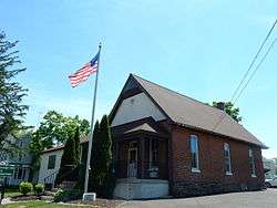 Borough Hall | |
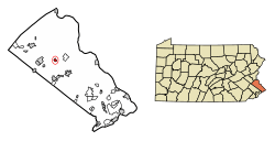 Location of Dublin in Bucks County, Pennsylvania. | |
 Dublin Location of Dublin in Pennsylvania  Dublin Dublin (the US) | |
| Coordinates: 40°22′24″N 75°12′09″W / 40.37333°N 75.20250°WCoordinates: 40°22′24″N 75°12′09″W / 40.37333°N 75.20250°W | |
| Country | United States |
| State | Pennsylvania |
| County | Bucks |
| Government | |
| • Body | Mayor, Council |
| • Mayor | Chris Hayes (R) |
| Area[1] | |
| • Total | 0.58 sq mi (1.51 km2) |
| • Land | 0.58 sq mi (1.51 km2) |
| • Water | 0.00 sq mi (0.00 km2) |
| Elevation | 597 ft (182 m) |
| Population (2010) | |
| • Total | 2,158 |
| • Estimate (2016)[2] | 2,157 |
| • Density | 3,699.83/sq mi (1,428.83/km2) |
| Time zone | UTC-5 (Eastern (EST)) |
| • Summer (DST) | UTC-4 (EDT) |
| ZIP code | 18917 |
| Area code(s) | 215 and 267 |
| FIPS code | 42-20104 |
| Website |
www |
Dublin is a borough in Bucks County, Pennsylvania, United States. The population was 2,158 at the 2010 census. Dublin is part of Pennridge School District.
Geography
Dublin is located at 40°22′24″N 75°12′9″W / 40.37333°N 75.20250°W (40.373270, -75.202464).[3]
According to the United States Census Bureau, the borough has a total area of 0.5 square miles (1.3 km2), all of it land.
Overview
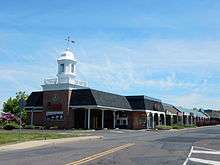
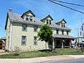
Dublin extends along a stretch of Pennsylvania Route 313 which connects the much larger towns of Doylestown and Quakertown. Almost the entire town can be viewed from 313 with only a few streets diverging from the main road. The town is surrounded by sparse housing developments and a series of dairy farms and nurseries, all of which are part of Hilltown Township and Bedminster Township. Dublin contains a small shopping center, a Department of Motor Vehicles Center, a pharmacy and 5 restaurants. Several rows of old houses line 313, some of which date back to the late 18th century. The majority of Dublin's population lives in several developments around the main part of town. Dublin has its own municipal government and maintains a fire station. Dublin has its own local police department and relies on Pennsylvania State Police when not on duty.
Demographics
| Historical population | |||
|---|---|---|---|
| Census | Pop. | %± | |
| 1880 | 86 | — | |
| 1920 | 223 | — | |
| 1930 | 296 | 32.7% | |
| 1940 | 351 | 18.6% | |
| 1950 | 400 | 14.0% | |
| 1960 | 517 | 29.3% | |
| 1970 | 657 | 27.1% | |
| 1980 | 1,565 | 138.2% | |
| 1990 | 1,985 | 26.8% | |
| 2000 | 2,083 | 4.9% | |
| 2010 | 2,158 | 3.6% | |
| Est. 2016 | 2,157 | [2] | 0.0% |
| Sources:[4][5][6] | |||
As of the 2010 census, the borough was 90.5% White, 1.4% Black or African American, 0.1% Native American, 2.0% Asian, and 2.1% were two or more races. 8.9% of the population were of Hispanic or Latino ancestry .
As of the census[5] of 2000, there were 2,083 people, 851 households, and 520 families residing in the borough. The population density was 3,825.7 people per square mile (1,489.4/km²). There were 869 housing units at an average density of 1,596.0 per square mile (621.3/km²). The racial makeup of the borough was 93.90% White, 1.59% African American, 0.19% Native American, 1.15% Asian, 0.14% Pacific Islander, 0.48% from other races, and 1.44% from two or more races. Hispanic or Latino of any race were 1.97% of the population.
There were 851 households, out of which 35.4% had children under the age of 18 living with them, 47.7% were married couples living together, 9.3% had a female householder with no husband present, and 38.8% were non-families. 29.1% of all households were made up of individuals, and 6.5% had someone living alone who was 65 years of age or older. The average household size was 2.45 and the average family size was 3.10.
In the borough the population was spread out, with 26.4% under the age of 18, 10.3% from 18 to 24, 38.5% from 25 to 44, 16.5% from 45 to 64, and 8.3% who were 65 years of age or older. The median age was 32 years. For every 100 females there were 98.6 males. For every 100 females age 18 and over, there were 99.6 males.
The median income for a household in the borough was $48,235, and the median income for a family was $55,724. Males had a median income of $37,441 versus $26,589 for females. The per capita income for the borough was $21,778. About 4.3% of families and 6.2% of the population were below the poverty line, including 6.2% of those under age 18 and 7.0% of those age 65 or over.
Climate
During the summer months, frequent episodes of high humidity occur. Occasionally, heat index values exceed 100 °F (38 °C). On average, the wettest month of the year is July which corresponds with the annual peak for thunderstorm activity. During the winter months, wind chill values occasionally fall below 0 °F (-18 °C). On average, the snowiest month of the year is February which corresponds with the annual peak for nor'easter activity.
| Climate data for Dublin Borough, Pennsylvania (1981 – 2010 averages). Elevation 563 ft (171 m). | |||||||||||||
|---|---|---|---|---|---|---|---|---|---|---|---|---|---|
| Month | Jan | Feb | Mar | Apr | May | Jun | Jul | Aug | Sep | Oct | Nov | Dec | Year |
| Average high °F (°C) | 37.7 (3.2) |
41.1 (5.1) |
49.4 (9.7) |
61.8 (16.6) |
71.6 (22) |
80.1 (26.7) |
84.2 (29) |
82.6 (28.1) |
75.7 (24.3) |
64.3 (17.9) |
53.3 (11.8) |
41.9 (5.5) |
62.0 (16.7) |
| Average low °F (°C) | 20.3 (−6.5) |
22.4 (−5.3) |
29.3 (−1.5) |
38.9 (3.8) |
48.6 (9.2) |
58.0 (14.4) |
62.8 (17.1) |
61.4 (16.3) |
53.5 (11.9) |
42.2 (5.7) |
33.6 (0.9) |
25.0 (−3.9) |
41.3 (5.2) |
| Average precipitation inches (mm) | 3.42 (86.9) |
2.77 (70.4) |
3.82 (97) |
4.08 (103.6) |
4.35 (110.5) |
4.38 (111.3) |
4.92 (125) |
4.01 (101.9) |
4.56 (115.8) |
4.30 (109.2) |
3.75 (95.3) |
4.02 (102.1) |
48.38 (1,229) |
| Average snowfall inches (cm) | 9.0 (22.9) |
10.0 (25.4) |
4.3 (10.9) |
0.8 (2) |
0.0 (0) |
0.0 (0) |
0.0 (0) |
0.0 (0) |
0.0 (0) |
0.0 (0) |
0.6 (1.5) |
4.4 (11.2) |
29.1 (73.9) |
| Source: PRISM[7] | |||||||||||||
Gallery
 Historic Dublin Post Office.
 Wagon near Former Dublin Post Office.
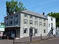 Dublin Inn.
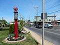 Historic Gas Pump on N. Main St.
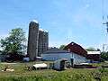 Moyer's Village Farm.
References
- ↑ "2016 U.S. Gazetteer Files". United States Census Bureau. Retrieved Aug 13, 2017.
- 1 2 "Population and Housing Unit Estimates". Retrieved June 9, 2017.
- ↑ "US Gazetteer files: 2010, 2000, and 1990". United States Census Bureau. 2011-02-12. Retrieved 2011-04-23.
- ↑ "Census of Population and Housing". U.S. Census Bureau. Archived from the original on 12 May 2015. Retrieved 11 December 2013.
- 1 2 "American FactFinder". United States Census Bureau. Archived from the original on 2013-09-11. Retrieved 2008-01-31.
- ↑ "Incorporated Places and Minor Civil Divisions Datasets: Subcounty Resident Population Estimates: April 1, 2010 to July 1, 2012". Population Estimates. U.S. Census Bureau. Archived from the original on 17 June 2013. Retrieved 11 December 2013.
- ↑
External links
| Wikimedia Commons has media related to Dublin, Pennsylvania. |
