Newtown Township, Bucks County, Pennsylvania
| Newtown Township | |
|---|---|
| Township | |
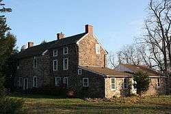 Peter Taylor Farmhouse, built 1750 | |
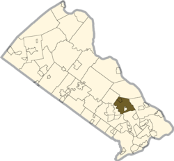 Location of Newtown Township in Bucks County | |
 Newtown Township Location in Pennsylvania and the United States  Newtown Township Newtown Township (the US) | |
| Coordinates: 40°13′47″N 74°56′10″W / 40.22972°N 74.93611°WCoordinates: 40°13′47″N 74°56′10″W / 40.22972°N 74.93611°W | |
| Country | United States |
| State | Pennsylvania |
| County | Bucks |
| Area[1] | |
| • Total | 11.98 sq mi (31.03 km2) |
| • Land | 11.90 sq mi (30.82 km2) |
| • Water | 0.08 sq mi (0.20 km2) |
| Elevation | 164 ft (50 m) |
| Population (2010) | |
| • Total | 19,299 |
| • Estimate (2016)[2] | 19,720 |
| • Density | 1,657.14/sq mi (639.83/km2) |
| Time zone | UTC-5 (EST) |
| • Summer (DST) | UTC-4 (EDT) |
| Area code(s) | 215 |
| FIPS code | 42-017-54192 |
| Website |
www |
Newtown Township is a township in Bucks County, Pennsylvania, United States. The population was 19,299 at the 2010 census (a predicted 19,720 in 2016).
History
Newtown Township traces its roots back to William Penn, who purchased 5,000 acres (20 km2) from the Lenni Lenape Indians in 1683. He named this land "my New Township", which gradually evolved to Newtown Township. Newtown served as the County Seat of Bucks County from 1726 until 1813, when the Court was moved to Doylestown. In 1838, the area comprising the commercial center, plus a number of homes, was incorporated into Newtown Borough. Today, the Township surrounds Newtown Borough and each has its own form of government.
Newtown Township is governed by a 5-member Board of Supervisors who oversee a full-time township manager. Members are elected to serve 6 year terms. As of 2015 the Township Supervisors were Michael Gallagher, Kyle Davis, Ryan Gallagher, Jen Dix and Phil Calabro.
Geography
According to the United States Census Bureau, the township consists of a total area of 12.0 square miles (31.0 km²), all of it land.
Former villages Spring Garden and Stoopville were located in the township.[3]
Natural features include Core Creek, Neshaminy Creek, and Newtown Creek.[3]
Demographics
| Historical population | |||
|---|---|---|---|
| Census | Pop. | %± | |
| 1930 | 712 | — | |
| 1940 | 816 | 14.6% | |
| 1950 | 1,013 | 24.1% | |
| 1960 | 1,468 | 44.9% | |
| 1970 | 2,002 | 36.4% | |
| 1980 | 4,527 | 126.1% | |
| 1990 | 13,685 | 202.3% | |
| 2000 | 18,206 | 33.0% | |
| 2010 | 19,299 | 6.0% | |
| Est. 2016 | 19,720 | [2] | 2.2% |
| [4] | |||
As of 2010 the 2010 census, the township was 87.8% Non-Hispanic White, 1.2% Black or African American, 0.1% Native American, 7.9% Asian, and 1.2% were two or more races. 1.9% of the population were of Hispanic or Latino ancestry.[5]
As of the census[6] of 2000, there were 18,206 people, 6,761 households, and 5,063 families residing in the township. The population density was 1,522.6 people per square mile (587.7/km²). There were 6,848 housing units at an average density of 572.7 per square mile (221.1/km²).
There were 6,761 households, out of which 42.6% had children under the age of 18 living with them, 64.7% were married couples living together, 7.8% had a female householder with no husband present, and 25.1% were non-families. 21.0% of all households were made up of individuals, and 5.6% had someone living alone who was 65 years of age or older. The average household size was 2.68 and the average family size was 3.17.
In the township the population was spread out, with 28.9% under the age of 18, 4.8% from 18 to 24, 34.1% from 25 to 44, 24.1% from 45 to 64, and 8.2% who were 65 years of age or older. The median age was 37 years. For every 100 females there were 93.2 males. For every 100 females age 18 and over, there were 88.5 males.
The median income for a household in the township was $80,532, and the median income for a family was $91,923. Males had a median income of $65,064 versus $41,087 for females. The per capita income for the township was $34,335. About 1.2% of families and 1.5% of the population were below the poverty line, including 1.9% of those under age 18 and 5.1% of those age 65 or over.
Parks and recreation
- Chandler Fields
- Clark Nature Center
- Helen Randle
- Roberts Ridge
- Carl Sedia
- Silver Lake Park
- Tyler State Park
- Newtown Skate Park
- Veterans Park
Notable people
- Deirdre Bolton, broadcast journalist and business news and commentator
- Jayson Stark, American sportswriter and author who covers baseball
- Felix Hirsch, German Jewish journalist and historian
- Kenneth Frazier, Chairman, President and CEO Merck & Co.
References
- ↑ "2016 U.S. Gazetteer Files". United States Census Bureau. Retrieved Aug 13, 2017.
- 1 2 "Population and Housing Unit Estimates". Retrieved June 9, 2017.
- 1 2 MacReynolds, George, Place Names in Bucks County, Pennsylvania, Doylestown, Bucks County Historical Society, Doylestown, PA, 1942, P1.
- ↑ http://www.dvrpc.org/data/databull/rdb/db82/appedixa.xls
- ↑ https://www.usatoday.com/news/nation/census/profile/PA
- ↑ "American FactFinder". United States Census Bureau. Retrieved 2008-01-31.
External links

- Newtown Township
