Upper Makefield Township, Bucks County, Pennsylvania
| Upper Makefield Township, Pennsylvania | |
|---|---|
| Township | |
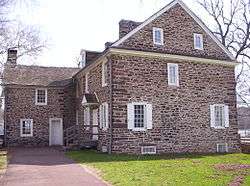 McConkey's Ferry Inn at Washington Crossing Historic Park | |
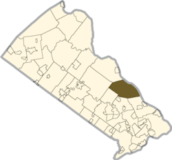 Location of Upper Makefield Township in Bucks County | |
 Upper Makefield Township  Upper Makefield Township | |
| Coordinates: 40°17′31″N 74°55′27″W / 40.29194°N 74.92417°WCoordinates: 40°17′31″N 74°55′27″W / 40.29194°N 74.92417°W | |
| Country | United States |
| State | Pennsylvania |
| County | Bucks |
| Area[1] | |
| • Total | 21.80 sq mi (56.46 km2) |
| • Land | 21.25 sq mi (55.04 km2) |
| • Water | 0.55 sq mi (1.42 km2) |
| Elevation | 161 ft (49 m) |
| Population (2010) | |
| • Total | 8,190 |
| • Estimate (2016)[2] | 8,392 |
| • Density | 394.92/sq mi (152.48/km2) |
| Time zone | UTC-5 (EST) |
| • Summer (DST) | UTC-4 (EDT) |
| Area code(s) | 215, 267 |
| FIPS code | 42-017-79128 |
| Website |
www |
Upper Makefield Township is a township in Bucks County, Pennsylvania, United States. The population was 8,190 at the 2010 census. It has the 8th highest per capita income for Pennsylvania townships. Its multimillion-dollar homes, top-notch public schools and easy commute to both Princeton and Philadelphia led to its ranking as Best Place to Live in the Suburbs in Philadelphia Magazine's Best Places to Live list.[3] Additionally, it has been listed as the 8th richest neighborhood in the Philadelphia area and 287th richest neighborhood in the United States with a mean household income of $306,081.[4] The area has also been listed an alternative to the Hamptons for the summer by New York Magazine.[5]
Geography
According to the United States Census Bureau, the township has a total area of 21.5 square miles (55.8 km²), of which, 20.9 square miles (54.2 km2) of it is land and 0.6 square miles (1.6 km²) of it (2.88%) is water.
Past and present place names in Upper Makefield include Buckmanville, Dolington, Jericho, Lizette, Lurgan, Washington Crossing, and Woodhill.[6]
Natural features include Houghs Creek, Jericho Mountain, and Pidcock Creek.[6]
Demographics
| Historical population | |||
|---|---|---|---|
| Census | Pop. | %± | |
| 1930 | 951 | — | |
| 1940 | 950 | −0.1% | |
| 1950 | 1,410 | 48.4% | |
| 1960 | 1,991 | 41.2% | |
| 1970 | 2,905 | 45.9% | |
| 1980 | 4,577 | 57.6% | |
| 1990 | 5,949 | 30.0% | |
| 2000 | 7,180 | 20.7% | |
| 2010 | 8,190 | 14.1% | |
| Est. 2016 | 8,392 | [2] | 2.5% |
| [7] | |||
As of the 2010 census, the township was 93.0% Non-Hispanic White, 1.1% Black or African American, 0.2% Native American, 2.5% Asian, and 1.0% were two or more races. 2.3% of the population were of Hispanic or Latino ancestry.[8]
As of the census[9] of 2000, there were 7,180 people, 2,512 households, and 2,105 families residing in the township. The population density was 343.1 people per square mile (132.5/km²). There were 2,598 housing units at an average density of 124.1/sq mi (47.9/km²). The racial makeup of the township was 97.12% White, 0.81% African American, 0.07% Native American, 1.27% Asian, 0.24% from other races, and 0.50% from two or more races. Hispanic or Latino of any race were 1.13% of the population.
There were 2,512 households, out of which 37.9% had children under the age of 18 living with them, 77.3% were married couples living together, 4.6% had a female householder with no husband present, and 16.2% were non-families. 12.3% of all households were made up of individuals, and 3.6% had someone living alone who was 65 years of age or older. The average household size was 2.86 and the average family size was 3.13.
In the township the population was spread out, with 26.7% under the age of 18, 5.1% from 18 to 24, 23.3% from 25 to 44, 34.7% from 45 to 64, and 10.2% who were 65 years of age or older. The median age was 42 years. For every 100 females, there were 96.7 males. For every 100 females age 18 and over, there were 99.6 males.
The median income for a household in the township was $102,759, and the median income for a family was $114,064. Males had a median income of $90,000 versus $42,365 for females. The per capita income for the township was $56,288. About 1.6% of families and 2.1% of the population were below the poverty line, including none of those under age 18 and 1.5% of those age 65 or over.
History
George Washington and the Continental Army crossed the Delaware River here the night of December 25–26, 1776, during the American Revolutionary War in preparation for the Battle of Trenton.
The Brownsburg Village Historic District, Buckmanville Historic District, John Burroughs Homestead, Dolington Village Historic District, John Chapman House, Eagle Tavern, Hayhurst Farm, Keith House-Washington's Headquarters, Makefield Meeting and Smith Family Farmstead are listed on the National Register of Historic Places.[10]
References
- ↑ "2016 U.S. Gazetteer Files". United States Census Bureau. Retrieved Aug 13, 2017.
- 1 2 "Population and Housing Unit Estimates". Retrieved June 9, 2017.
- ↑ http://www.phillymag.com/articles/best_places_to_live_2006/
- ↑ http://www.philly.com/philly/blogs/philadelphia-real-estate/The-richest-neighborhoods-in-the-Philadelphia-region.html
- ↑ http://nymag.com/nymag/features/coverstory/4740/index1.html
- 1 2 MacReynolds, George, Place Names in Bucks County, Pennsylvania, Doylestown, Bucks County Historical Society, Doylestown, PA, 1942, P1.
- ↑ http://www.dvrpc.org/data/databull/rdb/db82/appedixa.xls
- ↑ https://www.usatoday.com/news/nation/census/profile/PA
- ↑ "American FactFinder". United States Census Bureau. Retrieved 2008-01-31.
- ↑ National Park Service (2010-07-09). "National Register Information System". National Register of Historic Places. National Park Service.
External links
| Wikimedia Commons has media related to Upper Makefield Township, Bucks County, Pennsylvania. |
- Upper Makefield Township
- Upper Makefield Fire Company Home Page
- Washington Crossing Historic Park
- Friends of Washington Crossing Park
