Highton, Pennsylvania
| Highton, Pennsylvania | |
|---|---|
| Populated place | |
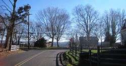 At the intersection of Street Road and Ridge Road | |
 Highton, Pennsylvania Location of Highton in Pennsylvania | |
| Coordinates: 40°19′20″N 74°59′19″W / 40.32222°N 74.98861°WCoordinates: 40°19′20″N 74°59′19″W / 40.32222°N 74.98861°W | |
| Country | United States |
| State | Pennsylvania |
| County | Bucks |
| Township | Buckingham, Solebury |
| Elevation[1] | 220 ft (67 m) |
| Time zone | UTC-5 (Eastern (EST)) |
| • Summer (DST) | UTC-4 (EDT) |
| Area code(s) | 215 |
| FIPS code | 42-34668 |
| GNIS feature ID | 1203806 |
Highton is a populated place situated along the border of Buckingham and Solebury townships in Bucks County, Pennsylvania.[2] The small settlement is located along Street Road (which runs along the township line) at its intersection with Ridge Road. As the latter road's name implies, it is located along a ridge (at an estimated elevation of 220 feet (67 m) above sea level[1]) between Pidcock Creek and Curls Run about three and a half miles (5.6 km) southeast of New Hope. There are a few houses located around the settlement, the remainder consists of farms and properties containing large houses over rolling terrain.[3]
References
- 1 2 "Feature Detail Report for: Highton". Geographic Names Information System. United States Geological Survey.
- ↑ "Highton (in Bucks County, PA) Populated Place Profile". PA Hometown Locator. Retrieved December 18, 2015.
- ↑ Google (December 26, 2015). "Aerial view of Highton" (Map). Google Maps. Google. Retrieved December 26, 2015.

This article is issued from
Wikipedia.
The text is licensed under Creative Commons - Attribution - Sharealike.
Additional terms may apply for the media files.