Caloocan
| Caloocan | |||
|---|---|---|---|
| Highly Urbanized City | |||
| City of Caloocan | |||
(2017-12-30).jpg) Caloocan City Hall | |||
| |||
| Nickname(s): Historic City of Caloocan | |||
| Motto(s): Tao ang Una | |||
| Anthem: "Caloocan, Mabuhay Ka" | |||
 Map of Metro Manila with Caloocan highlighted | |||
.svg.png) Caloocan Location within the Philippines | |||
| Coordinates: 14°39′N 120°58′E / 14.65°N 120.97°ECoordinates: 14°39′N 120°58′E / 14.65°N 120.97°E | |||
| Country |
| ||
| Region | National Capital Region (NCR) | ||
| Province | none (Former part of Rizal province until 1975) | ||
| District | 1st and 2nd Districts | ||
| Founded | 1815 | ||
| Cityhood | February 16, 1962 | ||
| Highly Urbanized City | December 22, 1979 | ||
| Barangays | 188 (see Barangays) | ||
| Government [1] | |||
| • Type | Sangguniang Panlungsod | ||
| • Mayor | Oscar Malapitan | ||
| • Vice Mayor | Macario Asistio III | ||
| • Representative, 1st District | Dale Gonzalo Malapitan | ||
| • Representative, 2nd District | Edgar Erice | ||
| • Electorate | 648,933 voters (2016) | ||
| Area [2] | |||
| • Total | 55.80 km2 (21.54 sq mi) | ||
| Population (2015 census)[3] | |||
| • Total | 1,583,978 | ||
| • Density | 28,000/km2 (74,000/sq mi) | ||
| Time zone | UTC+8 (PST) | ||
| ZIP code | 1400–1413, 1420–1428 | ||
| PSGC | 137501000 | ||
| IDD : area code | +63 (0)02 | ||
| Climate type | Tropical monsoon climate | ||
| Income class | 1st city income class | ||
| Revenue (₱) | 4,384,495,437.50 (2016) | ||
| Native languages |
Tagalog Taglish Swardspeak | ||
| Website |
www | ||


Caloocan, officially the City of Caloocan, (Tagalog: Lungsod ng Caloocan), or simply known as Caloocan City, is a 1st class highly urbanized city in Metro Manila, Philippines. According to the 2015 census, it has a population of 1,583,978 people[3] making it as the the fourth most populous city in the Philippines.
It is divided into two geographical locations with a total combined area of 5,333.40 hectares. It was formerly part of the Province of Rizal of the Philippines' Southern Luzon Region. The city's name is colloquially spelled as Kalookan. It comprises what is known as the CAMANAVA area along with cities Malabon, Navotas and Valenzuela.
The word caloocan comes from the Tagalog root word lo-ok; kalook-lookan (or kaloob-looban) means "innermost area". South Caloocan is bordered by Manila, Quezon City, Malabon, Navotas and Valenzuela. North Caloocan shares its border with Quezon City, Valenzuela and Marilao, Meycauayan and San Jose del Monte in the province of Bulacan.
History
Originally, Caloocan was a lowland area located on the corner where the old town of Tondo and Tambobong meet. Caloocan became a municipality when it was separated from Tondo in 1815. Its original territory was extended to Marikina, San Mateo and Montalban to the east; Tinajeros, Tanza and Tala rivers to the north; San Francisco del Monte, Sampalok, Sta. Cruz and Tondo in the south; and Dagat-dagatan and Aromahan to the west.
The city is historically significant because it was the center of activities for the Katipunan, the secret militant society that launched the Philippine Revolution during the Spanish occupation of the Philippines. In a house in Caloocan secret meetings were held by Andrés Bonifacio and his men, and it was in the city's perimeters where the first armed encounter took place between the Katipunan and the Spaniards. The revolution erupted after the Cry of Balintawak led by Andres Bonifacio
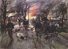
In 1899 the city saw heavy fighting in the Philippine–American War, at the Battle of Caloocan and the Second Battle of Caloocan.
In 1901, during the formation of the province of Rizal, Caloocan was included in its matrix. Novaliches became part of Caloocan pursuant to Act 942, as amended by Act 984 and Act 1008 of the Philippine Commission, which was transferred in 1949 for the formation of Quezon City.
In 1961, after Republic Act No. 3278 was approved by the Philippine Congress and the plebiscite was conducted. Caloocan was officially inducted into cityhood on February 16, 1962
Territorial changes
Caloocan once encompassed a much larger, contiguous area. The districts of Balintawak, La Loma and Novaliches were once part of Caloocan. Balintawak is a historic district because it was the original site of the "Cry of Pugad Lawin" (Unang Sigaw sa Balintawak) at a location called "Kang-kong" near Tandang Sora's house. Novaliches was an expansive sector with some hillsides that served as meeting places and hideouts for Andrés Bonifacio y de Castro and the Katipunan.
By the 1920s there was a consolidation of several municipalities. Caloocan annexed the neighbouring town of Novaliches, as stated in the Act 942, as amended by Acts 984 and 1008 of the Philippine Commission, bringing its total area to about 15,000 hectares. It extended to the foothills of Marikina, San Mateo and Montalban in the east; Tinajeros, Tanza and Tala rivers in the north; San Francisco del Monte, Sampalok, Sta. Cruz and Tondo in the south; and Dagat-Dagatan or Aromahan in the west.
When Quezon City was created in 1939, Caloocan ceded 1,500 hectares of land from the barrios or sitios of Balintawák, Balingasa, Kaingin, Kangkong, La Loma, Malamig, Matalahib, Masambong, Galas, San Isidro, San José, Santol and Tatalon. Instead of opposing the transfer, Caloocan residents willingly gave the land in the belief it will benefit the country's new capital city.
However, in 1949, Congress passed Republic Act No. 333, which redefined the Caloocan-Quezon City boundary. The barrios of Baesa, Talipapâ, San Bartolomé, Pasong Tamó, Novaliches, Banlat, Kabuyao, Pugad Lawin, Bagbag, Pasong Putik, which once belonged to Novaliches and had an area of about 8,100 hectares, were excised from Caloocan. The remaining portion of the Novaliches is now called North Caloocan. This split Caloocan into two parts: a southern section that is more urbanised, and a northern section that became suburban-rural.
Geography
Caloocan is divided into two non-contiguous areas. Southern Caloocan lies directly north of the Manila and is bounded by Malabon and Valenzuela to the north and west, Navotas to the west, and Quezon City to the east. Northern Caloocan is the northernmost territory of Metro Manila which most residents call Novaliches, Caloocan; it lies east of Valenzuela, north of Quezon City, and south of San Jose del Monte, Meycauayan and Marilao in the province of Bulacan. Caloocan's northern part is much larger than its southern half.
Barangays
Caloocan is divided into 188 barangays. The city uses a hybrid system for its barangays. All barangays have their corresponding numbers but only a few — mostly in the northern part — have corresponding names. However, names of barrios and districts do not necessarily coincide with barangay perimeters. Barangays in southern Caloocan are smaller compared to their northern counterparts.
Among the cities in Metro Manila, only Manila, Pasay and Caloocan implement the so-called "Zone Systems". A zone is a group of barangays in a district. Although a zone is considered a subdivision in the local government units, the people do not elect a leader for the zone in a popular election similar to the normal barangay or local elections. The zoning system is merely for statistical purposes. Caloocan has 16 zones. The biggest zone in Caloocan is Zone 15 in District 1 (North Caloocan) directly west of the second biggest zone in Caloocan which is Zone 16.
Barangay Bagong Silang (176) is the most populous barangay in the entire country with a population of 246,515 people.[3]
In 1957, the sitio of Bagbagin was separated from the barrio of Kaybiga and converted into a distinct barrio known as barrio Bagbagin.[4]
| Caloocan (South) | ||
|---|---|---|
| Barangay | Zone | Area/Name |
| Barangay 1 | 1[5] | Sangandaan |
| Barangay 2 | 1 | Sangandaan |
| Barangay 3 | 1 | Sangandaan |
| Barangay 4 | 1 | Sangandaan |
| Barangay 5 | 1 | Sangandaan |
| Barangay 6 | 1 | Sangandaan |
| Barangay 7 | 1 | Sangandaan |
| Barangay 8 | 1 | Dagat-Dagatan |
| Barangay 9 | 1 | Sangandaan |
| Barangay 10 | 1 | Sangandaan |
| Barangay 11 | 1 | Poblacion |
| Barangay 12 | 1 | Dagat-Dagatan |
| Barangay 13 | 2[6] | Poblacion (A. Mabini) |
| Barangay 14 | 2 | Dagat-Dagatan |
| Barangay 15 | 2 | Poblacion (A. Mabini) |
| Barangay 16 | 2 | Poblacion (A. Mabini) |
| Barangay 17 | 2 | Poblacion (A. Mabini) |
| Barangay 18 | 2 | Poblacion (A. Mabini) |
| Barangay 19 | 2 | Poblacion (A. Mabini) |
| Barangay 20 | 2 | C-3 Road, Kaunlaran Village |
| Barangay 21 | 2 | C-3 Road, Kaunlaran Village |
| Barangay 22 | 2 | C-3 Road, Kaunlaran Village |
| Barangay 23 | 2 | C-3 Road, Kaunlaran Village |
| Barangay 24 | 2 | C-3 Road, Kaunlaran Village |
| Barangay 25 | 3[7] | Maypajo |
| Barangay 26 | 3 | Maypajo |
| Barangay 27 | 3 | Maypajo |
| Barangay 28 | 3 | Dagat-Dagatan |
| Barangay 29 | 3 | Maypajo |
| Barangay 30 | 3 | Maypajo |
| Barangay 31 | 3 | Maypajo |
| Barangay 32 | 3 | Maypajo |
| Barangay 33 | 3 | Maypajo |
| Barangay 34 | 3 | Maypajo |
| Barangay 35 | 3 | Maypajo |
| Barangay 36 | 4[8] | Marulas |
| Barangay 37 | 4 | Marulas |
| Barangay 38 | 4 | Grace Park West |
| Barangay 39 | 4 | Grace Park West |
| Barangay 40 | 4 | Grace Park West |
| Barangay 41 | 4 | Grace Park West |
| Barangay 42 | 4 | Grace Park West |
| Barangay 43 | 4 | Grace Park West |
| Barangay 44 | 4 | Grace Park West |
| Barangay 45 | 4 | Grace Park West |
| Barangay 46 | 4 | Grace Park West |
| Barangay 47 | 4 | Grace Park West |
| Barangay 48 | 4 | Grace Park West |
| Barangay 49 | 5[9] | Grace Park West |
| Barangay 50 | 5 | Grace Park West |
| Barangay 51 | 5 | Grace Park West |
| Barangay 52 | 5 | Grace Park West |
| Barangay 53 | 5 | Grace Park West |
| Barangay 54 | 5 | Grace Park West |
| Barangay 55 | 5 | Grace Park West |
| Barangay 56 | 5 | Grace Park West |
| Barangay 57 | 5 | Grace Park West |
| Barangay 58 | 5 | Grace Park West |
| Barangay 59 | 6[10] | Grace Park West |
| Barangay 60 | 6 | Grace Park West |
| Barangay 61 | 6 | Grace Park West |
| Barangay 62 | 6 | Grace Park West |
| Barangay 63 | 6 | Grace Park West |
| Barangay 64 | 6 | Grace Park West |
| Barangay 65 | 6 | Grace Park West |
| Barangay 66 | 6 | Grace Park West |
| Barangay 67 | 6 | Grace Park West |
| Barangay 68 | 6 | Grace Park West |
| Barangay 69 | 6 | Grace Park West |
| Barangay 70 | 6 | Grace Park West |
| Barangay 71 | 7[11] | Grace Park West |
| Barangay 72 | 7 | Victory Liner Compound |
| Barangay 73 | 7 | PNR Compound |
| Barangay 74 | 7 | Heroes Del 96 |
| Barangay 75 | 7 | Heroes Del 96 |
| Barangay 76 | 7 | Monumento |
| Barangay 77 | 7 | Caimito Road |
| Barangay 78 | 7 | Monumento |
| Barangay 79 | 7 | Caimito Road |
| Barangay 80 | 7 | University Hills Subdivision (University of the East) |
| Barangay 81 | 8[12] | Morning Breeze Subdivision |
| Barangay 82 | 8 | Morning Breeze Subdivision |
| Barangay 83 | 8 | Morning Breeze Subdivision |
| Barangay 84 | 8 | Morning Breeze Subdivision |
| Barangay 85 | 8 | Morning Breeze Subdivision |
| Barangay 86 | 8 | Grace Park East, Calaanan Compound |
| Barangay 87 | 8 | Grace Park East |
| Barangay 88 | 8 | Grace Park East, Ever Gotesco Malls |
| Barangay 89 | 8 | Grace Park East |
| Barangay 90 | 8 | Grace Park East |
| Barangay 91 | 8 | Grace Park East, Our Lady of Grace |
| Barangay 92 | 8 | Grace Park East, Madre Ignacia |
| Barangay 93 | 8 | Grace Park East |
| Barangay 94 | 9[13] | Grace Park East, Biglang-Awa |
| Barangay 95 | 9 | Balintawak |
| Barangay 96 | 9 | Grace Park East |
| Barangay 97 | 9 | Grace Park East |
| Barangay 98 | 9 | Grace Park East |
| Barangay 99 | 9 | Dorotea Compound, Balintawak |
| Barangay 100 | 9 | Grace Park East |
| Barangay 101 | 9 | Grace Park East, Galino |
| Barangay 102 | 9 | Grace Park East, 9th Avenue |
| Barangay 103 | 9 | Grace Park East |
| Barangay 104 | 9 | Grace Park East |
| Barangay 105 | 9 | Grace Park East |
| Barangay 106 | 10[14] | Grace Park East |
| Barangay 107 | 10 | Grace Park East |
| Barangay 108 | 10 | Grace Park East |
| Barangay 109 | 10 | Grace Park East |
| Barangay 110 | 10 | Grace Park East |
| Barangay 111 | 10 | Grace Park East |
| Barangay 112 | 10 | Grace Park East |
| Barangay 113 | 10 | Grace Park East |
| Barangay 114 | 10 | Grace Park East |
| Barangay 115 | 10 | Grace Park East |
| Barangay 116 | 10 | Grace Park East |
| Barangay 117 | 10 | Grace Park East |
| Barangay 118 | 10 | Grace Park East |
| Barangay 119 | 10 | Grace Park East |
| Barangay 120 | 10 | Grace Park East |
| Barangay 121 | 11[15] | Grace Park East |
| Barangay 122 | 11 | Grace Park East |
| Barangay 123 | 11 | Grace Park East |
| Barangay 124 | 11 | Grace Park East |
| Barangay 125 | 11 | Grace Park East |
| Barangay 126 | 11 | Barrio San Jose |
| Barangay 127 | 11 | Barrio San Jose |
| Barangay 128 | 11 | Barrio San Jose |
| Barangay 129 | 11 | Barrio San Jose |
| Barangay 130 | 11 | Barrio San Jose |
| Barangay 131 | 11 | Barrio San Jose |
| Barangay 132 | 12[16] | Bagong Barrio West |
| Barangay 133 | 12 | Bagong Barrio West |
| Barangay 134 | 12 | Bagong Barrio West |
| Barangay 135 | 12 | Bagong Barrio West |
| Barangay 136 | 12 | Bagong Barrio West |
| Barangay 137 | 12 | Bagong Barrio West |
| Barangay 138 | 12 | Bagong Barrio West |
| Barangay 139 | 12 | Bagong Barrio West |
| Barangay 140 | 12 | Bagong Barrio West |
| Barangay 141 | 12 | Bagong Barrio West |
| Barangay 142 | 13[17] | Bagong Barrio West |
| Barangay 143 | 13 | Bagong Barrio West |
| Barangay 144 | 13 | Bagong Barrio West |
| Barangay 145 | 13 | Bagong Barrio West |
| Barangay 146 | 13 | Bagong Barrio West |
| Barangay 147 | 13 | Bagong Barrio West |
| Barangay 148 | 13 | Bagong Barrio West |
| Barangay 149 | 13 | Bagong Barrio West |
| Barangay 150 | 13 | Bagong Barrio West |
| Barangay 151 | 13 | Bagong Barrio West |
| Barangay 152 | 13 | Bagong Barrio West |
| Barangay 153 | 13 | Bagong Barrio West |
| Barangay 154 | 13 | Bagong Barrio West |
| Barangay 155 | 13 | Bagong Barrio West |
| Barangay 156 | 14[18] | Bagong Barrio East |
| Barangay 157 | 14 | Bagong Barrio East |
| Barangay 158 | 14 | Baesa, Eternal Gardens Memorial Park |
| Barangay 159 | 14 | Baesa |
| Barangay 160 | 14 | Libis Baesa |
| Barangay 161 | 14 | Libis Reparo |
| Barangay 162 | 14 | Santa Quiteria |
| Barangay 163 | 14 | Santa Quiteria |
| Barangay 164 | 14 | Talipapa |
| Caloocan (North) | |||||
|---|---|---|---|---|---|
| Barangay | Zone | Area/Name | |||
| Barangay 165 | 15[19] | Bagbaguin | |||
| Barangay 166 | 15 | Kaybiga | |||
| Barangay 167 | 15 | Llano (Llano Road, PLC Subdivision, Silanganan Subdivision, Sunriser Village, Sagrado Village, Dolmar Golden Hills Subdivision, Miranda Subdivision, Whispering Palms Subdivision) | |||
| Barangay 168 | 15 | Deparo (Deparo Road, Teofilo Samson Road, Kabatuhan Street) | |||
| Barangay 169 | 15 | BF Homes (Estrella Homes, Santa Fe Homesite, BF Homes Caloocan Phase 1, and 2) | |||
| Barangay 170 | 15 | Deparo 2 (Amparo Novaville, SM Homes, Cefels 2 Subdivision, Diamante Neighborhood, BF Homes Caloocan Phase 3) | |||
| Barangay 171 | 15 | Bagumbong (Bagumbong Road, Bagumbong Dulo, Taas Street, Rainbow Village V, Bankers Village, Shelterville) | |||
| Barangay 172 | 15 | Urduja Village, Merry Homes II, Zabarte | |||
| Barangay 173 | 15 | Congress Village, Palmera Spring II, Senate Village, Hillcrest Village | |||
| Barangay 174 | 15 | Camarin | |||
| Barangay 175 | 15 | Camarin | |||
| Barangay 176 | 15 | Bagong Silang (Langit Road) | |||
| Barangay 177 | 15 | Camarin (Cielito Homes, Capitol Parkland, Franville IV) | |||
| Barangay 178 | 15 | Camarin | |||
| Barangay 179 | 16[20] | Amparo, (Amparo Subdivision, Dela Costa Homes II, Capitol Park Homes II, Sacred Heart Village, Roseville Subdivision) | |||
| Barangay 180 | 16 | Tala (Miramonte Heights, Soldiers Hills III and Victory Heights Subdivision) | |||
| Barangay 181 | 16 | Pangarap Village | |||
| Barangay 182 | 16 | Pangarap Village | |||
| Barangay 183 | 16 | Tala (Midway Park Subd., Mountain Heights Subd.) | |||
| Barangay 184 | 16 | Tala (Bankers' Village II, Cefels Park III) | |||
| Barangay 185 | 16 | Tala (Malaria) | |||
| Barangay 186 | 16 | Tala (Barracks II, LD Village, Admin Site) | |||
| Barangay 187 | 16 | Tala (Barrio San Lazaro, Barrio San Jose, Barrio Santo Niño, Barrio San Roque, Sto. Cristo) | |||
| Barangay 188 | 16 | Tala (Phase 12, Riverside, San Isidro, Concepcion, Sta. Rita) | |||
Demographics
| Population census of Caloocan | ||
|---|---|---|
| Year | Pop. | ±% p.a. |
| 1903 | 7,847 | — |
| 1918 | 19,551 | +6.27% |
| 1939 | 38,320 | +3.26% |
| 1948 | 58,208 | +4.75% |
| 1960 | 145,523 | +7.93% |
| 1970 | 274,453 | +6.54% |
| 1975 | 397,201 | +7.70% |
| 1980 | 467,816 | +3.33% |
| 1990 | 763,415 | +5.02% |
| 1995 | 1,023,159 | +5.64% |
| 2000 | 1,177,604 | +3.06% |
| 2007 | 1,378,856 | +2.20% |
| 2010 | 1,489,040 | +2.84% |
| 2015 | 1,583,978 | +1.18% |
| Source: Philippine Statistics Authority[3] [21] [22] [23] | ||
As of 2015, the city has a population of 1,583,978 people, which makes it the fourth largest city in the Philippines in population.[3] Under the same census year, Caloocan South (Barangays 1 to 164) has a population of 585,091 and Caloocan North (Barangays 165 to 188) has a population of 998,887.
The population density of Caloocan (28,387 persons per square kilometer) surpasses that of the NCR population density.[24]
Of the country’s 238 legislative districts (LDs), the First LD of Caloocan was the biggest in terms of population size, with 1.19 million persons.[25]
Most residents speak both Filipino and English, with considerable numbers speaking other languages and dialects.
Like many other places in the country, Roman Catholicism is the predominant religion. There is a significant presence of Iglesia ni Cristo and other Protestant churches like Church of God Caloocan located at Baesa, Caloocan City.
Economy
Caloocan's 10th Avenue area is well known for the clusters of motorcycle dealers and motorcycle spare parts dealers. Among the major and famous streets are P. Zamora Street and A. Mabini Street.
Numerous banks have branches in the city such as Banco de Oro, East West Bank, MetroBank, Maybank, Chinabank, Bank of the Philippine Islands, Our Lady of Grace Credit Cooperative, etc.
The city also has a number of shopping malls and stand-alone supermarkets and hypermarkets including the former Ever Gotesco Grand Central (and future SM City Grand Central), Puregold Maypajo,Monumento and Caloocan, Victory Central Mall, Puregold Monumento, Araneta Square, Uniwide Warehouse Club Monumento, SM Hypermarket Monumento, and SM Center Sangandaan which are in Monumento area in the south. Savemore Market Kiko Camarin and iMall Camarin in Barangay 178 (Kiko Camarin), Zabarte Town Center, Savemore Market Zabarte, and Puregold Zabarte, are shopping malls in Barangay 175 Camarin area at the north. Puregold Deparo, which is opened last November 2015, and Ultra Mega Supermarket Deparo are stand-alone supermarkets at Barangay 168 Deparo which serves the residents of Deparo and the nearby barangays of Bagumbong and Llano.
Manila North Tollways Corporation (the concession holder of the North Luzon Expressway), is headquartered in Caloocan.
Local government
List of Mayors and Vice Mayors
| Municipality of Caloocan | ||
|---|---|---|
| Period of Tenure | Mayor | Vice Mayor |
| 1902–1904 | Pedro Sevilla | |
| 1904–1906 | Silverio Baltazar | |
| 1906–1908 | Tomas Susano | |
| 1908–1910 | Leon Nadurata | |
| 1910–1913 | Emilio Sanchez | |
| 1913–1915 | Godofredo Herrera | |
| 1915–1921 | Jose Sanchez | |
| 1922–1925 | Dominador Aquino | |
| 1926–1928 | Pablo Pablo | |
| 1928–1931 | Dominador Aquino | |
| 1932–1940 | Pablo Pablo | |
| 1941–1944 | Cornelio Cordero | |
| 1945–1946 | Oscar Baello | |
| 1946–1951 | Jesus Basa | Anacleto Bustamante (1950-1954) |
| 1952–1962 | Macario Asistio, Sr | Mateo Lualhati (1962-1963) |
| City of Caloocan | ||
| 1962–1971 | Macario Asistio, Sr. | Alejandro Fider (1964-1971) |
| 1972–1976 | Marcial Samson | Isagani Arcadio |
| 1976–1978 | Alejandro Fider | |
| 1978–1980 | Virgilio Robles | |
| 1980–1986 | Macario Asistio, Jr. | Macario "Mac" Floro Ramirez Sr. |
| 1986 | Virgilio Robles | Vicente Del Mundo |
| 1986–1987 | Antonio Martinez | Vicente del Mundo |
| 1987-1988 | Crisipulo San Gabriel | Lina Aurelio |
| 1988–1995 | Macario Asistio, Jr. | Celestino Rosca |
| 1995–1998 | Rey Malonzo | Nancy Quimpo |
| 1998-2001 | Oscar Malapitan | |
| 2001-2004 | Luis Varela | |
| 2004–2010 | Enrico Echiverri | |
| 2010-2013 | Edgar Erice | |
| 2013–2019 | Oscar Malapitan | Macario Asistio III |
Infrastructure
Transportation
The LRT-1 has a terminal at Monumento that passes through the city's 5th Avenue LRT Station. The railway traverses Rizal Avenue Extension and enters the City of Manila and Pasay City. The stretch can be traveled in about 30 minutes. Philippine National Railways also has a line, with its terminal at Samson Road, and passes through Caloocan railway station, Asistio Avenue railway station, and C-3 railway station. The currently under construction MRT-7 had also proposed two stations located at the northern part of Caloocan that will be passing at Sacred Heart MRT Station and Tala MRT Station.
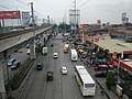
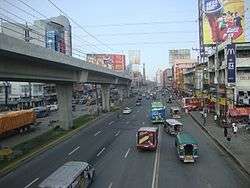
The city has an extensive network of roads, the most prominent being Epifanio de los Santos Avenue, which begins in the Monumento area. The North Luzon Expressway's Operations and Maintenance Center and the motorway's Balintawak Toll Barrier are in Caloocan.
Bus line Victory Liner Incorporated has its headquarters and terminal along in Rizal Avenue Extension near the Monumento Station.
Landmarks
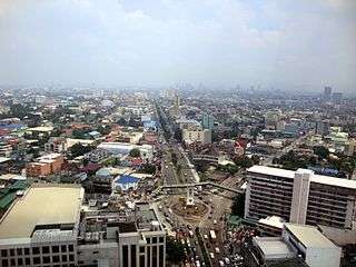
The city's most celebrated landmark is the monument to the revolutionary Andrés Bonifacio, which stands on a roundabout at the northern terminus of EDSA. The memorial was erected in 1933, and consists of an obelisk with sculptures by National Artist Guillermo Tolentino. The monument marks the very first battle of the Philippine Revolution on 3 August 1896.
Recent renovations have been made on the environs of the monument, including the Bonifacio Circle, its former site, and the Caloocan stretch of EDSA, which is 100 metres away from the landmark. The whole area is known as 'Monumento'.
City hall stands along A. Mabini Avenue in the southern part of the city, across the street from San Roque Parish Cathedral. The old city hall stands today at A. Mabini Street, 10th Avenue. There is a city hall in the northern part of the city. The city's District Office of the Bureau of Internal Revenue is along EDSA.
Police
The Caloocan City Police Station is under the parent agency National Capital Region Police Office's Northern Police District of the Philippine National Police.
The whole Caloocan City police force was recently sacked after a series of crimes, including killings and robberies, were committed by its members. However, instead of dismissing the erring police officers, they were scheduled to be retrained by PNP Chief Ronald Dela Rosa.
Education
The city's one public university is the University of Caloocan City (formerly Caloocan City Community College in 1971 and Caloocan City Polytechnic College in 1975). Other educational institutions of higher learning are the University of the East Caloocan, ABE International Business College, Holy Redeemer School of Kalookan, World Citi Colleges, Caloocan Central Elementary School and Manila Central University.
There are also several public and private schools such as Caloocan National Science and Technology High School (North Caloocan's first-ever science and technology high school; its students are admitted if they pass a competitive examination), Immaculada Concepcion College, Caloocan City Science High School, Caloocan City Business High School, Caloocan High School, Amparo High School, Maria Clara High School, Notre Dame of Greater Manila, Bagumbong High School (Main and Annex), Camarin High School, Tala High School, Manuel Luis Quezon High School, Sampaguita High School, Cielito Zamora High School, Bagong Silang High School, National Housing Corporation High School (NHC HS), Kalayaan National High School, Deparo High School, Escuela de Sophia of Caloocan, Inc., Guardian Angel School, Holy Infant Montessori Center, Saint Benedict School of Novaliches, Saint Dominic Savio School of Caloocan City, Saint Andrew School MHANLE Inc., Philippine Cultural College (Annex), Northern Rizal Yorklin School, Systems Plus Computer College, St. Mary's Academy of Caloocan City, St. Gabriel Academy, Asian Institute of Computer Studies - Caloocan, St. Clare College of Caloocan, Mystical Rose School of Caloocan, Holy Angel School of Caloocan Inc. , St. Agnes Academy of Caloocan Inc., St. Therese of Rose School, Young Achievers School of Caloocan, St. Joseph College of Novaliches, St. Raphaela Mary School of Caloocan, Our Lady of Lourdes Catholic School, Maranatha Christian Academy of Caloocan (Camarin), Kasarinlan High School, Camarin Elementary School and the two campuses of La Consolacion College (one is in Novaliches in the northern part and the other is on the southern part, near city hall).
There is a campus of Access Computer College, AMA Computer College Campus, a degree-awarding tertiary educational institution and STI Academic Center Caloocan at the Samson Road Road corner Caimito Road in front of UE Caloocan.
Twin towns – sister cities
Local
- Calamba, Laguna
- Malabon, Metro Manila
- San Jose del Monte, Bulacan
International
Gallery
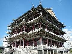 A century-old Taoist temple, near 5th Avenue LRT Station.
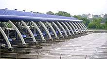
 Caloocan Sports Complex
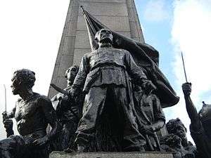
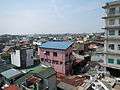 View of Brgy. 15 and 16 from City Hall
 Regional Trial Courts, Halls of Justice
.jpg) Vicariate of Our Lady of Grace, Diocesan Shrine of Our Lady of Grace, Roman Catholic Diocese of Kalookan
Vicariate of Our Lady of Grace, Diocesan Shrine of Our Lady of Grace, Roman Catholic Diocese of Kalookan
References
- ↑
- ↑ "Province: NCR, THIRD DISTRICT (Not a Province)". PSGC Interactive. Quezon City, Philippines: Philippine Statistics Authority. Retrieved 12 November 2016.
- 1 2 3 4 5 Census of Population (2015). "National Capital Region (NCR)". Total Population by Province, City, Municipality and Barangay. PSA. Retrieved 20 June 2016.
- ↑ "An Act to Convert the Sitio of Bagbagin, Municipality of Caloocan, Province of Rizal, into a Barrio to be known as Barrio Bagbagin of the Same Municipality and Separating it from the Barrio of Caybiga of the Same Municipality". LawPH.com. Retrieved 2011-04-12.
- ↑ Caloocan City Barangay Directory Zone 1 Archived 2009-10-07 at the Wayback Machine. Retrieved July 8, 2009
- ↑ Caloocan City Barangay Directory Zone 2 Retrieved July 8, 2009
- ↑ Caloocan City Barangay Directory Zone 3 Retrieved July 8, 2009
- ↑ Caloocan City Barangay Directory Zone 4 Retrieved July 8, 2009
- ↑ Caloocan City Barangay Directory Zone 5 Retrieved July 8, 2009
- ↑ Caloocan City Barangay Directory Zone 6 Archived 2010-10-11 at the Wayback Machine. Retrieved July 8, 2009
- ↑ Caloocan City Barangay Directory Zone 7 Retrieved July 8, 2009
- ↑ Caloocan City Barangay Directory Zone 8 Retrieved July 8, 2009
- ↑ Caloocan City Barangay Directory Zone 9 Retrieved July 8, 2009
- ↑ Caloocan City Barangay Directory Zone 10 Retrieved July 8, 2009
- ↑ Caloocan City Barangay Directory Zone 11 Retrieved July 8, 2009
- ↑ Caloocan City Barangay Directory Zone 12 Retrieved July 8, 2009
- ↑ Caloocan City Barangay Directory Zone 13 Retrieved July 8, 2009
- ↑ Caloocan City Barangay Directory Zone 14 Retrieved July 8, 2009
- ↑ Caloocan City Barangay Directory Zone 15 Retrieved July 8, 2009
- ↑ Caloocan City Barangay Directory Zone 16 Retrieved July 8, 2009
- ↑ Census of Population and Housing (2010). "National Capital Region (NCR)". Total Population by Province, City, Municipality and Barangay. NSO. Retrieved 29 June 2016.
- ↑ Censuses of Population (1903–2007). "National Capital Region (NCR)". Table 1. Population Enumerated in Various Censuses by Province/Highly Urbanized City: 1903 to 2007. NSO.
- ↑ "Province of Metro Manila, 3rd (Not a Province)". Municipality Population Data. Local Water Utilities Administration Research Division. Retrieved 17 December 2016.
- ↑ "Philippine Population Density (Based on the 2015 Census of Population)". Philippine Statistics Authority. Retrieved 6 December 2016.
- ↑ "Population Counts by Legislative District (Based on the 2015 Census of Population)". Philippine Statistics Authority. Retrieved 6 December 2016.
- ↑ mayors-of-caloocan List of Mayors and Vice Mayors of Caloocan
- ↑ "Sister cities". Manila Bulletin. Retrieved 30 August 2016.
External links
| Wikivoyage has a travel guide for Caloocan. |
| Wikimedia Commons has media related to Caloocan. |
- Official website
- History of Caloocan City, Philippines

Places adjacent to Caloocan | ||||||||||
|---|---|---|---|---|---|---|---|---|---|---|
| ||||||||||
Places adjacent to Caloocan | ||||||||||
|---|---|---|---|---|---|---|---|---|---|---|
| ||||||||||