Hartsburg, Missouri
Not to be confused with Harrisburg, a similarly-named settlement also in Boone County.
| Hartsburg, Missouri | |
|---|---|
| Village | |
 Hackman Building | |
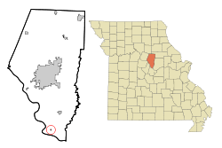 Location of Hartsburg, Missouri | |
| Coordinates: 38°41′42″N 92°18′32″W / 38.69500°N 92.30889°WCoordinates: 38°41′42″N 92°18′32″W / 38.69500°N 92.30889°W[1] | |
| Country | United States |
| State | Missouri |
| County | Boone |
| Area[2] | |
| • Total | 0.21 sq mi (0.54 km2) |
| • Land | 0.21 sq mi (0.54 km2) |
| • Water | 0 sq mi (0 km2) |
| Elevation[1] | 564 ft (172 m) |
| Population (2010)[3] | |
| • Total | 103 |
| • Estimate (2016)[4] | 105 |
| • Density | 490/sq mi (190/km2) |
| Time zone | UTC-6 (Central (CST)) |
| • Summer (DST) | UTC-5 (CDT) |
| ZIP code | 65039 |
| Area code(s) | 573 |
| FIPS code | 29-30718[5] |
Hartsburg is a village in southern Boone County, Missouri, United States. It is part of the Columbia, Missouri Metropolitan Statistical Area. The population was 103 at the 2010 census.
History
Hartsburg was named for Luther D. Hart, a pioneer settler.[6]
Geography
Hartsburg is located above the Missouri River bottom on Missouri Route A. The city of Marion in Cole County lies due west across the Missouri River. The community of Ashland lies about six miles to the northeast on U.S. Route 63. Hart Creek flows past the west side of the community.[7]
According to the United States Census Bureau, the village has a total area of 0.21 square miles (0.54 km2), all land.[2]
Demographics
| Historical population | |||
|---|---|---|---|
| Census | Pop. | %± | |
| 1910 | 175 | — | |
| 1920 | 211 | 20.6% | |
| 1930 | 155 | −26.5% | |
| 1940 | 154 | −0.6% | |
| 1950 | 171 | 11.0% | |
| 1960 | 158 | −7.6% | |
| 1970 | 120 | −24.1% | |
| 1980 | 118 | −1.7% | |
| 1990 | 131 | 11.0% | |
| 2000 | 108 | −17.6% | |
| 2010 | 103 | −4.6% | |
| Est. 2016 | 105 | [4] | 1.9% |
| U.S. Decennial Census[8] | |||
2010 census
As of the census[3] of 2010, there were 103 people, 48 households, and 20 families residing in the village. The population density was 490.5 inhabitants per square mile (189.4/km2). There were 59 housing units at an average density of 281.0 per square mile (108.5/km2). The racial makeup of the village was 94.2% White, 2.9% African American, 1.0% Native American, 1.0% Asian, and 1.0% from two or more races. Hispanic or Latino of any race were 1.9% of the population.
There were 48 households of which 20.8% had children under the age of 18 living with them, 35.4% were married couples living together, 6.3% had a female householder with no husband present, and 58.3% were non-families. 52.1% of all households were made up of individuals and 16.7% had someone living alone who was 65 years of age or older. The average household size was 2.15 and the average family size was 3.30.
The median age in the village was 41.6 years. 18.4% of residents were under the age of 18; 7.9% were between the ages of 18 and 24; 29.1% were from 25 to 44; 24.3% were from 45 to 64; and 20.4% were 65 years of age or older. The gender makeup of the village was 51.5% male and 48.5% female.
2000 census
As of the census[5] of 2000, there were 108 people, 54 households, and 30 families residing in the town. The population density was 1,327.0 people per square mile (521.2/km²). There were 59 housing units at an average density of 724.9 per square mile (284.8/km²). The racial makeup of the town was 89.81% White, 0.93% Native American, 2.78% from other races, and 6.48% from two or more races. Hispanic or Latino of any race were 2.78% of the population.
There were 54 households out of which 20.4% had children under the age of 18 living with them, 46.3% were married couples living together, 5.6% had a female householder with no husband present, and 44.4% were non-families. 38.9% of all households were made up of individuals and 20.4% had someone living alone who was 65 years of age or older. The average household size was 2.00 and the average family size was 2.67.
In the town the population was spread out with 16.7% under the age of 18, 5.6% from 18 to 24, 26.9% from 25 to 44, 29.6% from 45 to 64, and 21.3% who were 65 years of age or older. The median age was 45 years. For every 100 females, there were 120.4 males. For every 100 females age 18 and over, there were 95.7 males.
The median income for a household in the town was $32,500, and the median income for a family was $52,917. Males had a median income of $30,000 versus $21,875 for females. The per capita income for the town was $16,739. There were no families and 5.8% of the population living below the poverty line, including no under eighteens and 9.5% of those over 64.
Recreation
The Katy Trail, a 225-mile-long bike path stretching across the state of Missouri, runs along the edge of the Missouri River floodplain past Hartsburg.[7]
The Hartsburg Pumpkin Festival is held each year on the second Saturday and Sunday of October, which includes games, foods, and crafts.
Notable sites
- The Samuel E. Hackman Building is a historic building in Hartsburg.
References
- 1 2 U.S. Geological Survey Geographic Names Information System: Hartsburg, Missouri
- 1 2 "US Gazetteer files 2010". United States Census Bureau. Retrieved 2012-07-08.
- 1 2 "American FactFinder". United States Census Bureau. Retrieved 2012-07-08.
- 1 2 "Population and Housing Unit Estimates". Retrieved June 9, 2017.
- 1 2 "American FactFinder". United States Census Bureau. Retrieved 2008-01-31.
- ↑ Eaton, David Wolfe (1916). How Missouri Counties, Towns and Streams Were Named. The State Historical Society of Missouri. p. 212.
- 1 2 Missouri Atlas & Gazetteer, DeLorme, 1998, First edition, p. 37, ISBN 0-89933-224-2
- ↑ "Census of Population and Housing". Census.gov. Retrieved June 4, 2015.
External links
Municipalities and communities of Boone County, Missouri, United States | ||
|---|---|---|
| Cities | 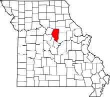 | |
| Villages | ||
| Townships | ||
| Unincorporated communities | ||
| Ghost towns | ||
| Footnotes | ‡a small part of Centralia is in Audrain County | |