Bear Creek (Colorado)
| Bear Creek[1] | |
|---|---|
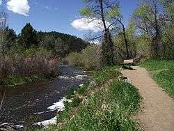 Bear Creek in Lair o' the Bear park. | |
| Physical characteristics | |
| Main source |
Clear Creek County, Colorado 39°35′51″N 105°38′29″W / 39.59750°N 105.64139°W |
| River mouth |
Confluence with South Platte 5,266 ft (1,605 m) 39°39′00″N 105°00′49″W / 39.65000°N 105.01361°WCoordinates: 39°39′00″N 105°00′49″W / 39.65000°N 105.01361°W |
| Basin features | |
| Progression |
South Platte—Platte Missouri—Mississippi |
| Basin size | Bear Creek Watershed[2] |
Bear Creek is a tributary of the South Platte River in central Colorado in the United States. Its source is Summit Lake near Mount Evans. The stream flows to a confluence with the South Platte River in Sheridan, Colorado just south of Denver. Bear Creek runs through the Bear Creek Watershed. Bear Creek Watershed is a 236 sq. mile watershed including all tributaries that discharge into the Bear Creek Reservoir. The two main tributaries are Bear Creek and Turkey Creek. The watershed extends from Mount Evans Wilderness to the Town of Morrison.[3]

Bear Creek leaving Summit Lake
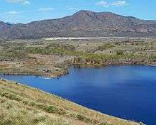
Bear Creek Lake near Morrison Colorado.
See also
References
- ↑ "Bear Creek". Geographic Names Information System. United States Geological Survey. Retrieved 2013-05-15.
- ↑ Bear Creek Watershed http://www.bearcreekwatershed.org/. Retrieved 2014-10-21. Missing or empty
|title=(help) - ↑ "Bear Creek Watershed". Retrieved 2014-10-21.
External links

This article is issued from
Wikipedia.
The text is licensed under Creative Commons - Attribution - Sharealike.
Additional terms may apply for the media files.