Astrolabe Glacier
| Astrolabe Glacier | |
|---|---|
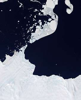 Natural-colour satellite image of Astrolabe | |
 Location of Astrolabe Glacier in Antarctica | |
| Type | unknown |
| Location | Adélie Land |
| Coordinates | 66°45′S 139°55′E / 66.750°S 139.917°E |
| Area | 96 km2 |
| Length | 19 km (12 mi) |
| Width | 7 km (4.3 mi) |
| Thickness | unknown |
| Terminus | Southern Ocean |
| Status | unknown |
Astrolabe Glacier is a glacier 7 kilometres (4 nmi) wide and 19 kilometres (10 nmi) long, flowing north-northeast from the continental ice and terminating at the coast in a prominent tongue at the east side of Geologie Archipelago.[1] It was first sighted in 1840 by the French expedition under Captain Jules Dumont d'Urville, although no glaciers were noted on d'Urville's chart of this coast but a formidable icy dike with perpendicular flanks[2] of 37.7 m high according to the joined plate,[3] corresponding to the glacier tongue.[4] The glacier was photographed from the air by U.S. Navy Operation Highjump in January 1947. It was charted by the French Antarctic Expedition, 1949–51, and named after d'Urville's flagship, the Astrolabe.
The Astrolabe Glacier Tongue (66°42′S 140°5′E / 66.700°S 140.083°E) is a prominent glacier tongue about 6 kilometres (3 nmi) wide and 7 kilometres (4 nmi) long, extending northeast from Astrolabe Glacier.
See also
References

Footnotes
- ↑ (in French) IGN Map of Pointe Géologie archipelago, site of Secretariat of the Antarctic Treaty, Documents, Historic Sites and Monuments.
- ↑ (in French) Voyage au Pôle sud et dans l'Océanie sur les corvettes "l'Astrolabe" et "la Zélée", exécuté par ordre du Roi pendant les années 1837-1838-1839-1840 sous le commandement de M. J. Dumont-d'Urville, capitaine de vaisseau, Paris, Gide éditeur, 1842-1846, tome 8, p. 149-152, site of Gallica, BNF. Clic first on Accéder au site complet down left of the page.
- ↑ (in French) Carte des explorations effectuées par les corvettes "l'Astrolabe" et "la Zélée" dans les régions circum-polaires, 1841 (plate of Voyage au Pôle sud et dans l'Océanie sur les corvettes "l'Astrolabe" et "la Zélée"), site of Secretariat of the Antarctic Treaty, Documents, Historic Sites and Monuments, enlarge for ships position number 38 near the glacier tongue called Pointe Géologie on the map.
- ↑ (in French) Prise de possession de la Terre Adélie (plate 171 of Voyage au Pôle sud et dans l'Océanie sur les corvettes "l'Astrolabe" et "la Zélée"), site of Secretariat of the Antarctic Treaty, Documents, Historic Sites and Monuments : view from the west towards the glacier tongue on January 22, 1840.