Arriba, Colorado
| Town of Arriba, Colorado | |
|---|---|
| Statutory Town | |
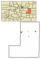 Location of Arriba in Lincoln County, Colorado. | |
 Town of Arriba, Colorado Location in the United States | |
| Coordinates: 39°17′03″N 103°16′26″W / 39.284058°N 103.273902°WCoordinates: 39°17′03″N 103°16′26″W / 39.284058°N 103.273902°W[1] | |
| Country |
|
| State |
|
| County[2] | Lincoln County |
| Incorporated | August 28, 1918[3] |
| Government | |
| • Type | Statutory Town[2] |
| Area[4] | |
| • Total | 0.44 sq mi (1.14 km2) |
| • Land | 0.44 sq mi (1.14 km2) |
| • Water | 0.00 sq mi (0.00 km2) |
| Elevation[5] | 5,239 ft (1,597 m) |
| Population (2010) | |
| • Total | 193 |
| • Estimate (2016)[6] | 201 |
| • Density | 456.82/sq mi (176.35/km2) |
| Time zone | UTC-7 (MST) |
| • Summer (DST) | UTC-6 (MDT) |
| ZIP code | 80804[7] |
| Area code(s) | 719 |
| FIPS code | 08-03235 |
| GNIS feature ID | 0195110 |
| Highways |
|
The Town of Arriba is a Statutory Town located in Lincoln County, Colorado, United States. The town population was 193 at the 2010 United States Census. Arriba is the Spanish word for "on high" or "above others."[8]
Geography
Arriba is located at 39°17′8″N 103°16′32″W / 39.28556°N 103.27556°W (39.285589, -103.275624),[9] along Interstate 70.
According to the United States Census Bureau, the town has a total area of 0.5 square miles (1.3 km2), all of it land.
Demographics
| Historical population | |||
|---|---|---|---|
| Census | Pop. | %± | |
| 1920 | 334 | — | |
| 1930 | 337 | 0.9% | |
| 1940 | 286 | −15.1% | |
| 1950 | 367 | 28.3% | |
| 1960 | 296 | −19.3% | |
| 1970 | 254 | −14.2% | |
| 1980 | 236 | −7.1% | |
| 1990 | 220 | −6.8% | |
| 2000 | 244 | 10.9% | |
| 2010 | 193 | −20.9% | |
| Est. 2016 | 201 | [6] | 4.1% |
| U.S. Decennial Census[10] | |||
As of the census[11] of 2000, there were 244 people, 106 households, and 62 families residing in the town. The population density was 523.1 people per square mile (200.4/km²). There were 127 housing units at an average density of 272.2 per square mile (104.3/km²). The racial makeup of the town was 94.67% White, 0.82% Native American, 1.64% Asian, 2.05% from other races, and 0.82% from two or more races. Hispanic or Latino of any race were 5.74% of the population.
There were 106 households out of which 26.4% had children under the age of 18 living with them, 48.1% were married couples living together, 6.6% had a female householder with no husband present, and 40.6% were non-families. 34.0% of all households were made up of individuals and 17.9% had someone living alone who was 65 years of age or older. The average household size was 2.30 and the average family size was 3.05.
In the town, the population was spread out with 25.8% under the age of 18, 6.1% from 18 to 24, 26.2% from 25 to 44, 23.4% from 45 to 64, and 18.4% who were 65 years of age or older. The median age was 41 years. For every 100 females, there were 96.8 males. For every 100 females age 18 and over, there were 96.7 males.
The median income for a household in the town was $25,000, and the median income for a family was $27,500. Males had a median income of $27,188 versus $19,000 for females. The per capita income for the town was $13,370. About 8.1% of families and 13.5% of the population were below the poverty line, including 3.0% of those under the age of eighteen and 19.6% of those sixty five or over.
Attractions
The Arriba Town Museum is located in the Arriba Town Hall and contains memorabilia and historic artifacts on the history of the area. Grandpa Jerry's Clown Museum started in 1986 in Sterling and moved to Arriba in 2001. The museum claims to be the largest known collection of collectible clowns (baby rattles, cookie jars, cups, salt and pepper shakers, tea sets, vases, "piggy" banks, music boxes, frames, porcelain pieces, lamps, puppets, etc.). The collection comprises items from 28 states and 13 countries.[12]
See also
References
- ↑ "2014 U.S. Gazetteer Files: Places". United States Census Bureau. July 1, 2014. Retrieved January 5, 2015.
- 1 2 "Active Colorado Municipalities". State of Colorado, Department of Local Affairs. 2007-02-27. Archived from the original on 2010-11-23. Retrieved 2007-02-27.
- ↑ "Colorado Municipal Incorporations". State of Colorado, Department of Personnel & Administration, Colorado State Archives. 2004-12-01. Archived from the original on 27 September 2007. Retrieved 2007-08-18.
- ↑ "2016 U.S. Gazetteer Files". United States Census Bureau. Retrieved Jul 25, 2017.
- ↑ "US Board on Geographic Names". United States Geological Survey. 2007-10-25. Retrieved 2008-01-31.
- 1 2 "Population and Housing Unit Estimates". Retrieved June 9, 2017.
- ↑ "ZIP Code Lookup". United States Postal Service. August 18, 2007. Archived from the original (JavaScript/HTML) on 18 August 2007. Retrieved August 18, 2007.
- ↑ Dawson, John Frank (1954). Place names in Colorado: why 700 communities were so named, 150 of Spanish or Indian origin. Denver, CO: The J. Frank Dawson Publishing Co. p. 7.
- ↑ "US Gazetteer files: 2010, 2000, and 1990". United States Census Bureau. 2011-02-12. Retrieved 2011-04-23.
- ↑ "Census of Population and Housing". Census.gov. Archived from the original on May 12, 2015. Retrieved June 4, 2015.
- ↑ "American FactFinder". United States Census Bureau. Archived from the original on 2013-09-11. Retrieved 2008-01-31.
- ↑ Lincoln County Tourism http://lincolncountycoloradotourism.com/arriba.htm
External links
| Wikimedia Commons has media related to Arriba, Colorado. |
Municipalities and communities of Lincoln County, Colorado, United States | ||
|---|---|---|
| Towns |  | |
| Unincorporated communities | ||
