Ngawa Tibetan and Qiang Autonomous Prefecture
| Aba Prefecture 阿坝州 · རྔ་བ་ཁུལ། · Ggabba zhou | |
|---|---|
| Autonomous Prefecture | |
|
阿坝藏族羌族自治州 · རྔ་བ་བོད་རིགས་ཆ་བ༹ང་རིགས་རང་སྐྱོང་ཁུལ · Ggabba Shbea Rrmea nyujugvez zhou Ngawa Tibetan and Qiang Autonomous Prefecture | |
 | |
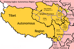
 Ngawa-Qiang Autonomous Prefecture (top centre) in Sichuan | |
| Coordinates: 31°55′N 101°43′E / 31.917°N 101.717°ECoordinates: 31°55′N 101°43′E / 31.917°N 101.717°E | |
| Country | People's Republic of China |
| Province | Sichuan |
| Prefecture seat | Barkam (Barkam Town) |
| Government | |
| • Party Committee Secretary | Liu Zuoming (刘作明) |
| • Governor | Yang Kening (杨克宁) |
| Area | |
| • Total | 83,201 km2 (32,124 sq mi) |
| Population (2013) | |
| • Total | 919,987 |
| • Density | 11/km2 (29/sq mi) |
| • Major Ethnic Groups |
Tibetan-53.72% Han-24.69% Qiang- 18.28% |
| Time zone | UTC+08:00 (China Standard) |
| Area code(s) | 0837 |
| ISO 3166 code | CN-SC-32 |
| GDP Total | ¥ 23.4 billion [2013] [1] |
| GDP Per Capita | ¥ 16,000 |
| License Plate Prefix | 川U |
| Website | Aba China |
| Ngawa Tibetan and Qiang Autonomous Prefecture | |||||||
| Chinese name | |||||||
|---|---|---|---|---|---|---|---|
| Simplified Chinese | 阿坝藏族羌族自治州 | ||||||
| Traditional Chinese | 阿壩藏族羌族自治州 | ||||||
| |||||||
| Abbreviated as "Aba Prefecture" | |||||||
| Simplified Chinese | 阿坝州 | ||||||
| Traditional Chinese | 阿壩州 | ||||||
| |||||||
| Tibetan name | |||||||
| Tibetan | རྔ་བ་བོད་རིགས་དང་ཆང་རིགས་རང་སྐྱོང་ཁུལ་ | ||||||
| |||||||
| Qiang name | |||||||
| Qiang | Ggabba Shbea Rrmea nyujugvez zhou | ||||||
Ngawa Tibetan and Qiang Autonomous Prefecture, also known as Aba (Tibetan: རྔ་བ་བོད་རིགས་དང་ཆང་རིགས་རང་སྐྱོང་ཁུལ་, Wylie: rnga ba bod rigs cha'ang rigs rang skyong khul ; Qiang: Ggabba Shbea Rrmea nyujugvez zhou; simplified Chinese: 阿坝藏族羌族自治州; traditional Chinese: 阿壩藏族羌族自治州), is an autonomous prefecture of northwestern Sichuan, bordering Gansu to the north and northeast and Qinghai to the northwest. Its seat is in Barkam, and it has an area of 83,201 km2 (32,124 sq mi). The population was 919,987 in late 2013.[2]
The county of Wenchuan in Ngawa is the site of the epicenter of the 2008 Sichuan earthquake, in which over 20,000 of its residents died and 40,000 injured.
History and Names
In the 8th century the Gyalrong area was visited by Vairotsana.
In 1410 Je Tsongkhapa's student Tshakho Ngawang Tapa established the first Gelug monastery in the area called "Gyalrong".
In contemporary history, most of Ngawa was under the 16th Administrative Prefecture of Szechwan (四川省第十六行政督察區), which was established by the Republic of China (ROC).[3]
The People's Republic of China defeated ROC troops in this area and established a Tibetan autonomous prefecture by late 1952. It was renamed Aba Tibetan Autonomous Prefecture in 1956 and Aba Tibetan and Qiang Autonomous Prefecture in 1987.[4]
On May 12, 2008, a major earthquake occurred in Wenchuan County (Tibetan: ལུང་དགུ་, Wylie: lung dgu ), a county in the southeastern part of this autonomous prefecture. 20,258 people were killed, 45,079 injured, 7,696 missing in the prefecture as of June 6, 2008.[5][6]
Internet access in the prefecture has been severely restricted.[7]
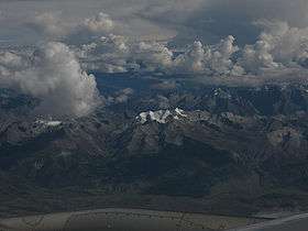
Geography
Most of the prefecture lies in the Tibetan cultural and historical region of Amdo, the southern part in Kham. The west, and part of Kardze, is also known as Gyalrong. Tribes in the Gyalrong area use a Qiangic language known as Gyalrong language. The source of the Min River and its tributary Dadu River are to be found in Ngawa.
Demographics
As of 2013, the prefecture's population was 919,987 inhabitants at a density of 10.91 per km²:[2]
| Ethnic group | Population | Proportion of total |
|---|---|---|
| Tibetan | 489,747 | 57.3% |
| Han | 220,353 | 20.6% |
| Qiang | 157,905 | 18.6% |
| Hui | 26,353 | 3.3% |
| Yi | 685 | 0.08% |
| Manchu | 373 | 0.04% |
| Miao | 266 | 0.03% |
| Mongols | 202 | 0.02% |
| Tujia | 182 | 0.02% |
| Bai | 101 | 0.01% |
| Zhuang | 95 | 0.01% |
| others | 278 | 0.03% |
Languages
Major languages spoken in Aba Prefecture include Khams Tibetan, Mandarin Chinese and many vernaculars of the Qiangic languages which vary from county to county:
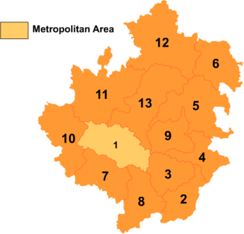
Administrative divisions
The region is composed of one county-level city and twelve counties:
| Map | |||||||||
|---|---|---|---|---|---|---|---|---|---|
 | |||||||||
| # | Name | Hanzi | Pinyin | Tibetan | Wylie | Qiang | Population (2010 Census) |
Area (km²) | Density (/km²) |
| 1 | Barkam City (Ma'erkang City) |
马尔康市 | Mǎ'ěrkāng Shì | འབར་ཁམས་གྲོང་ཁྱེར། | 'bar khams rdzong | Muerkvua shi | 58,437 | 6,639 | 8.80 |
| 2 | Wenchuan County | 汶川县 | Wènchuān Xiàn | ལུང་དགུ་རྫོང་། / ཁྲི་ཚང་རྫོང་། | lung dgu rdzong / khri tshang rdzong | 100,771 | 4,083 | 24.68 | |
| 3 | Li County | 理县 | Lǐ Xiàn | བཀྲ་ཤིས་གླིང་། | bkra shis gling | pauɕuq | 46,556 | 4,318 | 10.78 |
| 4 | Mao County | 茂县 | Mào Xiàn | མའོ་ཝུན། | ma'o wun | ʂqini | 104,829 | 4,075 | 25.72 |
| 5 | Songpan County | 松潘县 | Sōngpān Xiàn | ཟུང་ཆུ་རྫོང་། | zung chu rdzong | 72,309 | 8,486 | 8.52 | |
| 6 | Jiuzhaigou County | 九寨沟县 | Jiǔzhàigōu Xiàn | གཟི་རྩ་སྡེ་དགུ་རྫོང་། | gzi rtsa sde dgu rdzong | 81,394 | 5,286 | 15.39 | |
| 7 | Jinchuan County | 金川县 | Jīnchuān Xiàn | ཆུ་ཆེན་རྫོང་། | chu chen rdzong | 65,976 | 5,524 | 11.94 | |
| 8 | Xiaojin County | 小金县 | Xiǎojīn Xiàn | བཙན་ལྷ་རྫོང་། | btsan lha rdzong | 77,731 | 5,571 | 13.95 | |
| 9 | Heishui County | 黑水县 | Hēishuǐ Xiàn | ཁྲོ་ཆུ་རྫོང་། | khro chu rdzong | khǝtʂǝp | 60,704 | 4,154 | 14.61 |
| 10 | Zamtang County (Rangtang County) |
壤塘县 | Rǎngtáng Xiàn | འཛམ་ཐང་རྫོང་། | 'dzam thang rdzong | 39,173 | 6,836 | 5.73 | |
| 11 | Ngawa County (Aba County) |
阿坝县 | Ābà Xiàn | རྔ་བ་རྫོང་། | rnga ba rdzong | Ggabba | 72,391 | 10,435 | 6.93 |
| 12 | Zoigê County (Ruo'ergai County) |
若尔盖县 | Ruò'ěrgài Xiàn | མཛོད་དགེ་རྫོང་། | mdzod dge rdzong | 74,619 | 10,437 | 7.14 | |
| 13 | Hongyuan County | 红原县 | Hóngyuán Xiàn | རྐ་ཁོག་རྫོང་། / ཁྱུང་མཆུ་རྫོང་། | rka khog rdzong / khyung mchu rdzong | 43,818 | 8,398 | 5.21 | |
Though situated within Wenchuan County, Wolong National Nature Reserve and Wolong Special Administrative Region are administered separately by the Forestry Department of Sichuan.
Transportation
The prefecture is served by Hongyuan Airport in the west and Jiuzhai Huanglong Airport in the east. Private taxis can be hired from these airports. Jiuzhaigou Train Station is under construction 55 km (34 mi) north-west of Jiuzhaigou County's town. The railway is to run between Chengdu and Lanzhou.
Tourism
Tourism produced 71.0% of the GDP of the prefecture in 2006.[8] There are many places of interest in the prefecture, including
- Wolong National Nature Reserve in Wenchuan County, a well-known giant panda reserve where the China Conservation and Research Center for the Giant Panda was established in 1980
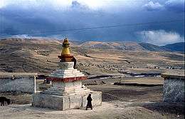
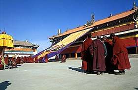
- Kirti Gompa, a 15th-century Tibetan Buddhism monastery
- Nangzhik Gompa monastery, founded in the 12th century
- Huanglong Scenic and Historic Interest Area in Songpan County
- Jiuzhaigou, Jiuzhaigou County, a nature reserve known for its many multi-level waterfalls and colorful lakes, declared a UNESCO World Heritage Site in 1992
- Mount Siguniang (Chinese: 四姑娘山 Tibetan: སྐུ་བླ, Wylie: sku bla "Sku Mountain"; formerly Chinese: 四姑山, a transcription), the highest point of the Qionglai Mountains, on the border between Xiaojin County (Chinese: 小金县; Tibetan: Tibetan: བཙན་ལྷ ) and Wenchuan County.
References
- ↑ Ngawa Prefecture Government. 中国·阿坝州. www.abazhou.gov.cn (in Chinese).
- 1 2 "基本州情" (in Chinese). 阿坝藏族羌族自治州人民政府. Retrieved 2015-05-04.
- ↑ "Öйú°¢°ÓÖÝ". abazhou.gov.cn.
- ↑ 历史和民族. Ngawa Prefecture People's Government. Retrieved 2018-08-13.
- ↑ "Casualties in Wenchuan Earthquake" (in Chinese). Sina.com. 2008-06-02. Retrieved 2008-06-02.
- ↑ "Death Toll in Aba Prefecture Rose to 20,258 as of June 6, 18:00 CST" (in Chinese). Official website of Aba Prefecture Government. 2008-06-07. Archived from the original on 2008-06-09. Retrieved 2008-06-07.
- ↑ Beam, Christopher (2013-12-05), "Behind China's Cyber Curtain. Visiting the country's far reaches, where the government shut down the Internet", New Republic
- ↑ Ngawa Prefecture Government. 中国阿坝州. abazhou.gov.cn (in Chinese).
Further reading
External links
| Wikivoyage has a travel guide for Aba (prefecture). |
| Wikimedia Commons has media related to Aba Tibetan and Qiang Autonomous Prefecture. |
| Regions |
|  | |||||||
|---|---|---|---|---|---|---|---|---|---|
| Prefectures and counties |
| ||||||||
| |||||||||