Luding County
| Luding County 泸定县 · ལྕགས་ཟམ་རྫོང་། | |
|---|---|
| County | |
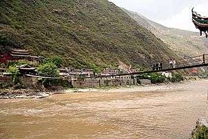 Luding Bridge crossing the Dadu River | |
.png) Location of Luding County (red) within Garzê Preefecture (yellow) and Sichuan | |
| Coordinates: 29°55′12″N 102°15′0″E / 29.92000°N 102.25000°ECoordinates: 29°55′12″N 102°15′0″E / 29.92000°N 102.25000°E | |
| Country | People's Republic of China |
| Province | Sichuan |
| Prefecture-level city | Garzê |
| County seat | Luqiao Town (泸桥镇) |
| Area | |
| • Total | 2,165 km2 (836 sq mi) |
| Population (2004) | |
| • Total | 80,000 |
| • Density | 37/km2 (96/sq mi) |
| • Major nationalities |
Han - 84.86% Tibetan - 10.06% Yi - 4.4% |
| Time zone | UTC+8 (China Standard) |
| Postal code | 626100 |
| Area code(s) | 0836 |
| Website |
www |
Luding County (simplified Chinese: 泸定县; traditional Chinese: 瀘定縣; pinyin: Lúdìng Xiàn), also known via its Tibetan name as Chagsam or Jagsam Tibetan: ལྕགས་ཟམ་རྫོང་།, Wylie: lcags zam rdzong, ZYPY: Jagsam Zong ) is a part of the Garzê Tibetan Autonomous Prefecture in the Chinese Province of Sichuan. Luding County covers an area of 2,165 km2 (836 sq mi) and has a population of approximately 80,000 (at the end of 2004). The census in the year 2000 recorded a population of 77,855.
Administrative divisions
Luding County contains four towns and eight townships:
- Luqiao Town (泸桥镇), 19,459 inhabitants (2000), seat of the county government;
- Lengqi Town (冷碛镇), 8,900 inhabitants (2000);
- Xinglong Town (兴隆镇), 9,522 inhabitants (2000);
- Moxi Town (磨西镇), 6,794 inhabitants (2000);
- Lan'an Township (岚安乡), 2,789 inhabitants (2000);
- Pengba Township (烹坝乡), 4,156 inhabitants (2000);
- Tianba Township (田坝乡), 4,124 inhabitants (2000);
- Chuni Township (杵坭乡), 2,966 inhabitants (2000);
- Jiajun Township (加郡乡), 3,873 inhabitants (2000);
- Dewei Township (德威乡), 4,602 inhabitants (2000);
- Xinxing Township (新兴乡), 4,568 inhabitants (2000);
- Detuo Township (得妥乡), 6,102 inhabitants (2000)
Ethnic Composition of the Population of Luding County (2000)
A Census in the year 2000 counted 77,855 inhabitants in total.
| Ethnic Group | Inhabitants | Portion |
|---|---|---|
| Han | 66,066 | 84.86% |
| Tibetan | 7,834 | 10.06% |
| Yi | 3,424 | 4.4% |
| Mongols | 253 | 0.32% |
| Others | 278 | 0.36% |
Transport
Climate
| Climate data for Luding (1981−2010) | |||||||||||||
|---|---|---|---|---|---|---|---|---|---|---|---|---|---|
| Month | Jan | Feb | Mar | Apr | May | Jun | Jul | Aug | Sep | Oct | Nov | Dec | Year |
| Record high °C (°F) | 23.4 (74.1) |
29.4 (84.9) |
36.3 (97.3) |
35.5 (95.9) |
36.3 (97.3) |
36.3 (97.3) |
37.8 (100) |
36.1 (97) |
34.9 (94.8) |
30.6 (87.1) |
26.3 (79.3) |
22.0 (71.6) |
37.8 (100) |
| Average high °C (°F) | 12.2 (54) |
14.5 (58.1) |
18.7 (65.7) |
23.3 (73.9) |
25.8 (78.4) |
26.7 (80.1) |
28.5 (83.3) |
28.1 (82.6) |
25.0 (77) |
21.1 (70) |
17.5 (63.5) |
13.3 (55.9) |
21.2 (70.2) |
| Daily mean °C (°F) | 6.7 (44.1) |
8.9 (48) |
12.4 (54.3) |
16.5 (61.7) |
19.4 (66.9) |
21.1 (70) |
22.7 (72.9) |
22.4 (72.3) |
19.8 (67.6) |
16.2 (61.2) |
12.2 (54) |
7.8 (46) |
15.5 (59.9) |
| Average low °C (°F) | 2.8 (37) |
4.9 (40.8) |
8.0 (46.4) |
12.0 (53.6) |
15.1 (59.2) |
17.2 (63) |
18.8 (65.8) |
18.7 (65.7) |
16.4 (61.5) |
12.9 (55.2) |
8.6 (47.5) |
3.9 (39) |
11.6 (52.9) |
| Record low °C (°F) | −4.2 (24.4) |
−3.5 (25.7) |
−2.4 (27.7) |
3.4 (38.1) |
6.0 (42.8) |
10.6 (51.1) |
13.2 (55.8) |
11.7 (53.1) |
9.9 (49.8) |
5.3 (41.5) |
0.2 (32.4) |
−3.2 (26.2) |
−4.2 (24.4) |
| Average precipitation mm (inches) | 0.8 (0.031) |
2.4 (0.094) |
18.2 (0.717) |
42.7 (1.681) |
72.4 (2.85) |
116.7 (4.594) |
140.3 (5.524) |
148.0 (5.827) |
86.4 (3.402) |
34.4 (1.354) |
7.6 (0.299) |
1.0 (0.039) |
670.9 (26.412) |
| Average relative humidity (%) | 54 | 53 | 56 | 60 | 66 | 74 | 78 | 78 | 77 | 73 | 65 | 59 | 66 |
| Source: China Meteorological Data Service Center | |||||||||||||
External links
| County-level divisions |  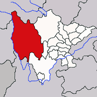 | |
|---|---|---|
| Towns and villages |
| |
| Geography | ||
| Landmarks | ||
This article is issued from
Wikipedia.
The text is licensed under Creative Commons - Attribution - Sharealike.
Additional terms may apply for the media files.