Wilkes-Barre, Pennsylvania
Wilkes-Barre (/ˈwɪlksˌbɛər/ or /-bɛəri/) is a city in the Commonwealth of Pennsylvania and the county seat of Luzerne County. It is one of the principal cities in the Scranton–Wilkes-Barre–Hazleton, PA Metropolitan Statistical Area. Located at the center of the Wyoming Valley, it is second in size to the nearby city of Scranton. The Scranton–Wilkes-Barre–Hazleton, PA Metropolitan Statistical Area had a population of 563,631 as of the 2010 Census, making it the fourth-largest metro/statistical area in the state of Pennsylvania. Wilkes-Barre and the surrounding Wyoming Valley are framed by the Pocono Mountains to the east, the Endless Mountains to the north and west, and the Lehigh Valley to the south. The Susquehanna River flows through the center of the valley and defines the northwestern border of the city.
Wilkes-Barre, Pennsylvania | |
|---|---|
City and County seat | |
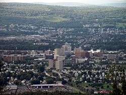
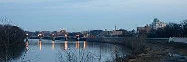
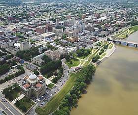 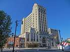   From top to bottom, left to right: Downtown Wilkes-Barre along the Susquehanna River, Wilkes-Barre Public Square, Luzerne County Courthouse, Panorama of Wilkes Barre | |
 Seal | |
| Nickname(s): The Diamond City, Coal City, Dub City, The W-B | |
| Motto(s): Pattern After Us | |
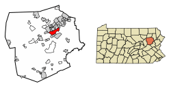 Location of Wilkes-Barre in Luzerne County, Pennsylvania. | |
 Wilkes-Barre Location in Luzerne County, Pennsylvania  Wilkes-Barre Wilkes-Barre (the United States) | |
| Coordinates: 41°14′40″N 75°52′41″W | |
| Country | |
| State | |
| County | Luzerne |
| Founded | 1769 |
| Incorporated | 1806: Borough |
| 1871: City | |
| Named for | John Wilkes, Isaac Barré |
| Government | |
| • Type | Mayor–council |
| • Body | Wilkes-Barre City Council |
| • Mayor | George Brown (D) |
| Area | |
| • City and County seat | 7.31 sq mi (18.93 km2) |
| • Land | 6.98 sq mi (18.08 km2) |
| • Water | 0.33 sq mi (0.85 km2) |
| Elevation | 525 ft (160 m) |
| Population (2010) | |
| • City and County seat | 41,498 |
| • Estimate (2019)[2] | 40,766 |
| • Density | 5,846.13/sq mi (2,257.12/km2) |
| • Metro | 562,037 (US: 95th) |
| Time zone | UTC−5 (EST) |
| • Summer (DST) | UTC−4 (EDT) |
| ZIP Codes[3] | 18701–18703, 18705, 18706, 18710, 18711, 18762, 18764–18767, 18769, 18773 |
| Area code | 570 and 272[4] |
| FIPS code | 42-85152 |
| Website | www.wilkes-barre.city |
Wilkes-Barre was founded in 1769 and formally incorporated in 1806. The city grew rapidly in the 19th century after the discovery of nearby coal reserves and the arrival of hundreds of thousands of immigrants who provided a labor force for the local mines. The coal mining fueled industrialization in the city, which reached the height of its prosperity in the first half of the 20th century. Its population peaked at more than 86,000. Following World War II, the city's economy declined due to the collapse of industry. The Knox Mine disaster accelerated this trend after large portions of the area's coal mines were flooded and could not be reopened. Today, the city has a population of 40,569, making it the largest city in Luzerne County and the 13th-largest city in Pennsylvania.
History
18th century

By the 18th century, the Wyoming Valley was inhabited by the Shawnee and Delaware Indian (Lenape) tribes. In 1753, the Susquehanna Company was founded in Connecticut for settling the Wyoming Valley (in modern-day Pennsylvania). Connecticut succeeded in purchasing the land from the Native Americans; however, Pennsylvania already claimed the very same territory through a purchase they made in 1736. In 1762, roughly two hundred Connecticut settlers (Yankees) established a settlement near Mill Creek. They planted wheat and constructed log cabins. The Yankees returned to New England for the winter.[5]
The Connecticut settlers returned in the spring of 1763 with their families and additional supplies. A party of Iroquois also visited the area with the dual purpose of turning the Delaware (Lenape) against the colonists and killing Teedyuscung, a local Delaware chief. On April 19, 1763, the residence of the chief, along with several others, was set ablaze. Chief Teedyuscung perished in the inferno. The Iroquois let the Delaware believe that this atrocity was committed by the settlers. As a result, the Delaware attacked the colonists on October 15, 1763. Thirty settlers were killed, and several others were taken prisoner. Those who managed to escape fled back to New England. The Delaware then burned what was left of the Yankee settlement.[5]
In 1769, the Yankees returned to the Wyoming Valley. Five townships were established by Connecticut. Each one was five square miles and divided amongst forty settlers. Wilkes-Barre Township was one of the original townships; it was named in honor of John Wilkes and Isaac Barré—two British members of Parliament who supported colonial America. Pennsylvanians (Pennamites) also arrived in the valley that same year.[5]
The Connecticut settlers established Fort Durkee, which was named in honor of their leader (Colonel Durkee). This was immediately followed by a series of skirmishes between the Pennsylvanians and Connecticut settlers. The land changed hands several times between the two groups. The Congress of the Confederation was asked to resolve the matter. With the Decree of Trenton, on December 30, 1782, the confederation government officially decided that the region belonged to Pennsylvania; the Wyoming Valley became part of Northumberland County.[5]
Pennsylvania ruled that the Connecticut settlers (Yankees) were not citizens of the Commonwealth. Therefore, they could not vote and were ordered to give up their property claims. In May 1784, armed men from Pennsylvania force-marched the Connecticut settlers away from the valley. By November, the Yankees returned with a greater force. They captured and destroyed Fort Dickinson in Wilkes-Barre. With that victory, a new state (which was separate from both Connecticut and Pennsylvania) was proposed. The new state was to be named Westmoreland. To ensure that they didn't lose the land, the Commonwealth of Pennsylvania worked out a compromise with the Connecticut (Yankee) settlers. The Yankee settlers would become citizens of Pennsylvania and their property claims would be restored (prior to the Decree of Trenton). As part of the compromise, Pennsylvania would establish a new county in Northeastern Pennsylvania. The Yankees agreed to the terms.[5]
On September 25, 1786, the Pennsylvania General Assembly passed a resolution which created Luzerne County. It was formed from a section of Northumberland County and named after Chevalier de la Luzerne, a French soldier and diplomat during the 18th century. Wilkes-Barre became the seat of government for the new territory. This resolution ended the idea of creating a new state.[5][6][7]
In 1797, several decades after the community's founding, Louis Philippe, later the King of France from 1830 to 1840, stayed in Wilkes-Barre while traveling to the French Asylum settlement.[8]
19th century
.jpg)
Wilkes-Barre's population skyrocketed due to the discovery of anthracite coal in the 19th century. In 1808, Judge Jesse Fell of Wilkes-Barre discovered a solution to ignite anthracite with the usage of an iron grate; it allowed for the coal to light and burn easier. This invention increased the popularity of anthracite as a fuel source. This led to the expansion of the coal industry in Northeastern Pennsylvania; Wilkes-Barre was nicknamed "The Diamond City" due to its high productivity of mining coal. The growing demand for coal as a domestic heat source resulted in changes to patterns of immigration to Wilkes-Barre in the 19th century. The Pennsylvania guide, compiled by the Writers' Program of the Works Progress Administration in 1940, noted that:[9]
Until 1870 all immigration was from the north of Europe, with the Irish predominating. Then mine operators sent representatives to central and southern Europe to induce peasants to come to the American coal fields. Many of the older workers consequently were supplanted by newcomers willing to work for low wages, and bitter conflicts followed. The cleavage along national lines, however, gave to Wilkes-Barre such picturesque sections as Five Points, now East End, where a crowd of miners used to gather nightly on the steps of Mackin Brothers' Store, a scene described by Con Carbon in a popular ballad of the 1890s:
And once thy peaceful tide
The Far Downs and Connaught men
Fight, and then make up again,
Dutch and Scotch and English men—
All like chickens in a pen.
The powder smoke does be so thick,
You could not cut it with a pick,
The smell of gas would make you sick
In front of Mackin's store.— Federal Writers'Project, "Part II: Cities and Towns", Pennsylvannia: A Guide to the Keystone State (1940)
Throughout the 1800s, canals and railroads were constructed to aid in the mining and transportation of coal. Hundreds of thousands of immigrants flocked to the city; they were seeking jobs in the numerous mines and collieries that sprang up throughout the region. In 1806, Wilkes-Barre Borough was formed from a segment of Wilkes-Barre Township; it was later incorporated as a city in 1871. This was the direct result of the population boom. At its peak, Wilkes-Barre had a population of over 86,000 in the 1930s and 40s.
New industries were established and the Vulcan Iron Works was a well-known manufacturer of railway locomotives from 1849 to 1954. During Wilkes-Barre's reign as an industrial and economic force in America, several major companies and franchises became based in the city, such as Woolworth's, Sterling Hotels, Miner's Bank, Bell Telephone, Luzerne National Bank, and Stegmaier.[10]
Even though the overall economy was doing very well, the city was still prone to natural disasters. Besides frequent flooding from the Susquehanna River, Wilkes-Barre also endured a devastating F3 tornado on August 19, 1890. The twister killed 16 people, injured 50, damaged or destroyed 260 buildings, and cost at least $240,000 (in 1890 money).[11]
20th century

.jpg)
Wilkes-Barre is located within Pennsylvania's Coal Region. The anthracite coal mining industry, and its extensive use of child labor in the early 20th century, was one of the industries targeted by the National Child Labor Committee and its hired photographer, Lewis Hine. Many of Hine's subjects were photographed in the mines and coal fields near Wilkes-Barre. The impact of the Hine photographs led to the enactment of child labor laws across the country.[12]
The coal industry continued despite several disasters, including an explosion at Wilkes-Barre's Baltimore Colliery in 1919, which killed 92 miners. The industry declined when the United States switched to other energy sources, and most coal operations had left Wilkes-Barre by the end of World War II. The 1959 Knox Mine Disaster, resulting in the flooding of numerous mines, marked the end of large-scale coal mining in the area. Industrial restructuring also caused the city to lose jobs and begin a decades-long decline.[13]
In 1926, Planters Peanuts Company was founded in Wilkes-Barre by two Italian immigrants. The company maintained its headquarters in the city until 1961.[14] In 1929, baseball player Babe Ruth hit one of the longest home runs in history at Artillery Park in Wilkes-Barre.[15]
In November 1972, 365 subscribers of Service Electric Cable were the first to receive HBO's premium cable television service, making Wilkes-Barre the birthplace of modern cable TV programming.[16]
Flooding
Manufacturing and retail remained Wilkes-Barre's strongest industries, but the city's economy took a major blow from Tropical Storm Agnes in 1972. The storm pushed the Susquehanna River to a height of nearly 41 feet (12 m), four feet above the city's levees, flooding downtown with nine feet of water. A total of 128 deaths were attributed to the storm. Most drowning deaths were caused by people trapped in their cars. Almost 400,000 homes and businesses were destroyed and 220,000 Pennsylvanians were left homeless (as were hundreds of thousands in other states). Damage was estimated to be $2.1 billion in Pennsylvania alone. President Richard Nixon sent aid to the area, after flying over in his helicopter on his way to his Camp David retreat (on June 24, 1972).[17][18]
Throughout the 1970s and 1980s, Wilkes-Barre attempted to prevent the damage from storms as intense as Agnes by building a levee system that rises 41 feet (12 m); completed in January 2003, the network of levees cost roughly $250 million.[19] It has successfully resisted other threatening floods in 1996, 2004, and 2006. The Army Corps of Engineers has praised the quality of the levees. In 2006, the city made the front page of national newspapers when 200,000 residents were told to evacuate in the wake of flooding that was forecast to reach levels near that of 1972, though the flooding fell short of predictions.[20]
In late August 2011, Hurricane Irene off the New Jersey coast caused the Susquehanna River to rise to flood level, but there was no cause for alarm. Then, from September 6 to 8, heavy rains from the inland remnants of Tropical Storm Lee and Hurricane Katia offshore funneled heavy rain over the Wyoming Valley and into the Susquehanna River watershed. The Susquehanna swelled to record levels across the state. In Wilkes-Barre, it crested on September 9 at an all-time record of 42.66 feet (13 m),[21] nearly 2 feet (0.6 m) higher than water levels reached during Hurricane Agnes in 1972. The levees protected Wilkes-Barre, but nearby boroughs were not as lucky. West Pittston, Plymouth, and parts of Plains Township were affected by extreme flooding.
21st century
Revitalization and construction


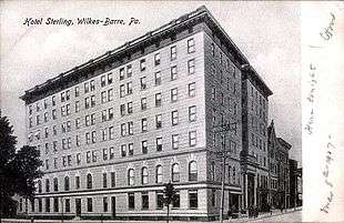
On June 9, 2005, Mayor Thomas M. Leighton unveiled his "I believe..." campaign for Wilkes-Barre, which was intended to boost the city's spirits. Construction began on a planned downtown theatre complex, which had a grand opening on June 30, 2006. Renovation of the landmark Hotel Sterling was being pursued by CityVest, a nonprofit developer. The expansion of Wilkes University and King's College took place. Also, the canopy and matching street lights in Public Square and across downtown were removed; they were replaced by new green lampposts.
The City of Wilkes-Barre celebrated its 200th anniversary in 2006. Several events, including a Beach Boys concert, were planned but canceled due to extremely heavy rains. Most of the city's population was ordered to evacuate on June 28, 2006. The Bicentennial celebration was postponed to Labor Day weekend, September 3, 2006, and was attended by Pennsylvania Governor Ed Rendell and the Beach Boys.
The Riverfront revitalization project (River Common), broke ground in 2007 and was completed in early 2010. It has made the riverfront accessible to the public. The area also has a new amphitheater for live performances and improved access through ramps and sidewalks. Fountains and color-changing lights have been added underneath two bridges which carry pedestrian traffic across the normally-open levee. The project stretches approximately four blocks from the Luzerne County Courthouse to the intersection of South River Street and West South Street. The River Common has since hosted concerts and charity events.
Since completion of the River Common, additional improvements to city infrastructure have been progressing. New crosswalks have been installed downtown, including signage emphasizing that pedestrians have the right-of-way. The completion of the James F. Conahan Intermodal Transportation Facility has added parking and relocated Luzerne County buses from their former Public Square staging sites. This has reduced traffic congestion around the square. Private carrier Martz offers coach bus service from the terminal as well.[22]
The widening and realignment of Coal Street, a major road connecting Wilkes-Barre City with Wilkes-Barre Township, was completed in 2012. The new Coal Street provides four lanes over the original two lanes, making travel between the highly commercial Wilkes-Barre Township and the city much easier. In 2013, Hotel Sterling was demolished due to flood damage in the hotel's basement (which compromised the building's integrity). As of today, several buildings are in the process of being constructed on the site of the former hotel.[23]
Geography


According to the United States Census Bureau, the city has a total area of 7.2 square miles (19 km2), of which 6.8 square miles (18 km2) is land and 0.3 square miles (0.78 km2), or 4.60%, is water. The city is bordered by the Susquehanna River to the west. Most of Downtown is located on a wide floodplain. Floodwalls were constructed to protect a large percentage of the city. The elevation of the downtown area is about 550 feet (170 m) above sea level. As you travel inland, away from the river, the elevation rises. Wilkes-Barre Mountain is a physical barrier southeast of the city.
Neighborhoods
Wilkes-Barre houses over one dozen neighborhoods:
- Central City: It is also referred to as "Downtown." This section of the city is located between the Susquehanna River and Wilkes-Barre Boulevard, and between South and North Streets. It is the original foundation of Wilkes-Barre (the 16 blocks claimed by the Connecticut settlers who founded the city). The neighborhood is home to most of the city's high-rises and its one Public Square. Throughout the city's history, the area has remained a hub for all of Luzerne County. During the city's boom, this small area was home to the headquarters of more than 100 national corporations. Today, it still houses the NEPA Headquarters for Verizon, Citizen's Bank, Blue Cross, PNC Bank, Luzerne National Bank, Guard Insurance, and a number of other companies. Thousands of people live and/or work in Downtown Wilkes-Barre every day.
- North End: This is the area northeast of Downtown. It comprises a number of urban and suburban communities. North End is renowned for its architecture.
- Parsons: This neighborhood is also northeast of Downtown. This is a quiet part of the city (with a suburban atmosphere). It includes two city parks, a golf course, and a number of factories.
- Miners' Mills: This community was named after a prominent local family (who lived in the area). Miners' Mills is the last neighborhood on the northeastern border of the city.
- East End: This neighborhood is directly east of Downtown. East End, Heights, and Mayflower are fairly new areas compared to the rest of the city, having only been developed in the 20th Century. Old pictures of the Stegmaier Building indicate that everything east of Downtown was undeveloped until the 1900s.
- Heights: This section of the city is located southeast of Downtown. It is centered between East End and Mayflower.
- Mayflower: This area is located south of Downtown. It was once home to numerous mansions owned by various "bigwigs." Today it houses the OKT, Lincoln Plaza, and Park Avenue residential housing communities. The best view of Downtown can be seen from the high streets of Mayflower.
- South Wilkes-Barre: This neighborhood is located directly southwest of Downtown. It was home to the national headquarters of Planter's Peanuts and the Bell Telephone Company (in the 20th Century). One of the tallest churches in Luzerne County, St. Nicholas Roman Catholic Church, dominates the south end skyline (standing at nearly 200 feet).
- Goose Island: This area is located in the southwestern section of the city between South Wilkes-Barre and Rolling Mill Hill.
- Rolling Mill Hill: This neighborhood is also located in the southwestern part of the city.
- Iron Triangle: This is another community southwest of Downtown.
- Other neighborhoods and sub-neighborhoods: There are other smaller neighborhoods and sub-neighborhoods in Wilkes-Barre City (e.g., Brookside, Upper Miners' Mills, Lower Miners' Mills, and Barney Farms).
Adjacent municipalities
- Wilkes-Barre Township (southeast)
- Plains Township (east and northeast)
- Kingston (north)
- Edwardsville (northwest)
- Larksville (west)
- Hanover Township (southwest)
- Bear Creek Township (southwest)
Climate
Wilkes-Barre has a humid continental climate (Köppen climate classification Dfa/Dfb) with four distinct seasons. Winters are cold with a January average of 25.8 °F (−3.4 °C).[24] The surrounding mountains have an influence on the climate (including both precipitation and temperatures), leading to wide variations within a short distance.[25] On average, temperatures below 0 °F (−17.8 °C) are infrequent, occurring 3 days per year, and there are 36 days where the maximum temperature remains below 32 °F (0.0 °C).[25] The average annual snowfall is 46.2 inches (117 cm) during the winter (in which severe snowstorms are rare).[25] However, when snowstorms do occur, they can disrupt normal routines for several days.[25]
Summers are warm with a July average of 71.4 °F (21.9 °C).[24] In an average summer, temperatures exceeding 90 °F (32.2 °C) occur on 9 days and can occasionally exceed 100 °F (37.8 °C).[26] Spring and fall are unpredictable with temperatures ranging from cold to warm (although they are usually mild). On average, Wilkes-Barre receives 38.2 inches (970 mm) of precipitation each year, which is relatively evenly distributed throughout the year (though the summer months receive more precipitation).[26] Extreme temperatures range from −21 °F (−29.4 °C) on January 21, 1994, to 103 °F (39.4 °C) on July 9, 1936.[26] Wilkes-Barre averages 2,303 hours of sunshine per year, ranging from a low of 96 hours in December (or 33% of possible sunshine) to 286 hours in July (or 62% of possible sunshine).[27]
| Climate data for Wilkes-Barre/Scranton Int'l Airport, Pennsylvania (1981–2010 normals,[lower-alpha 1] extremes 1901–present[lower-alpha 2]) | |||||||||||||
|---|---|---|---|---|---|---|---|---|---|---|---|---|---|
| Month | Jan | Feb | Mar | Apr | May | Jun | Jul | Aug | Sep | Oct | Nov | Dec | Year |
| Record high °F (°C) | 69 (21) |
76 (24) |
85 (29) |
93 (34) |
93 (34) |
99 (37) |
103 (39) |
102 (39) |
100 (38) |
91 (33) |
81 (27) |
71 (22) |
103 (39) |
| Mean maximum °F (°C) | 55.4 (13.0) |
56.4 (13.6) |
69.6 (20.9) |
81.3 (27.4) |
86.6 (30.3) |
89.8 (32.1) |
91.8 (33.2) |
90.0 (32.2) |
85.7 (29.8) |
77.3 (25.2) |
68.7 (20.4) |
57.5 (14.2) |
93.4 (34.1) |
| Average high °F (°C) | 33.2 (0.7) |
36.8 (2.7) |
46.2 (7.9) |
59.1 (15.1) |
69.7 (20.9) |
77.7 (25.4) |
81.9 (27.7) |
79.9 (26.6) |
72.3 (22.4) |
60.7 (15.9) |
49.4 (9.7) |
37.5 (3.1) |
58.8 (14.9) |
| Average low °F (°C) | 18.5 (−7.5) |
20.7 (−6.3) |
27.6 (−2.4) |
38.2 (3.4) |
47.6 (8.7) |
56.5 (13.6) |
60.9 (16.1) |
59.5 (15.3) |
52.1 (11.2) |
41.1 (5.1) |
33.3 (0.7) |
23.8 (−4.6) |
40.1 (4.5) |
| Mean minimum °F (°C) | −0.8 (−18.2) |
3.2 (−16.0) |
9.1 (−12.7) |
24.0 (−4.4) |
34.4 (1.3) |
43.1 (6.2) |
49.4 (9.7) |
47.1 (8.4) |
37.5 (3.1) |
28.3 (−2.1) |
18.9 (−7.3) |
5.9 (−14.5) |
−3.1 (−19.5) |
| Record low °F (°C) | −21 (−29) |
−19 (−28) |
−4 (−20) |
8 (−13) |
27 (−3) |
34 (1) |
43 (6) |
38 (3) |
29 (−2) |
19 (−7) |
6 (−14) |
−13 (−25) |
−21 (−29) |
| Average precipitation inches (mm) | 2.37 (60) |
2.03 (52) |
2.55 (65) |
3.33 (85) |
3.52 (89) |
4.03 (102) |
3.79 (96) |
3.41 (87) |
4.07 (103) |
3.34 (85) |
3.14 (80) |
2.68 (68) |
38.26 (972) |
| Average snowfall inches (cm) | 14.2 (36) |
9.3 (24) |
9.0 (23) |
3.3 (8.4) |
0 (0) |
0 (0) |
0 (0) |
0 (0) |
0 (0) |
0.1 (0.25) |
2.9 (7.4) |
7.4 (19) |
46.2 (117) |
| Average precipitation days (≥ 0.01 in) | 12.0 | 11.0 | 11.8 | 12.3 | 13.2 | 12.8 | 11.2 | 11.3 | 10.2 | 10.7 | 11.2 | 11.5 | 139.2 |
| Average snowy days (≥ 0.1 in) | 9.3 | 7.7 | 5.0 | 1.7 | 0 | 0 | 0 | 0 | 0 | 0.1 | 2.1 | 7.1 | 33.0 |
| Average relative humidity (%) | 70.1 | 67.5 | 63.3 | 60.4 | 64.6 | 70.5 | 71.1 | 73.8 | 75.2 | 71.6 | 71.8 | 72.5 | 69.4 |
| Mean monthly sunshine hours | 130.3 | 143.7 | 185.7 | 210.5 | 246.9 | 269.7 | 285.7 | 257.2 | 200.2 | 173.3 | 104.3 | 95.9 | 2,303.4 |
| Percent possible sunshine | 44 | 48 | 50 | 53 | 55 | 60 | 62 | 60 | 54 | 50 | 35 | 33 | 52 |
| Source: NOAA (relative humidity 1964–1990, sun 1961–1990)[26][24][27] | |||||||||||||
Parks and recreation

Wilkes-Barre has a Downtown Riverfront Park system that contains 91 acres of open space.[29]
Kirby Park is a public park located along the western bank of the Susquehanna River. Kirby Park is one of the region's most valued recreational resources. Given to the City of Wilkes-Barre by the Kirby Family, the park welcomes hundreds of thousands each year. The park is the setting for the City of Wilkes-Barre's annual Cherry Blossom Festival (held during the last weekend of April) and the city's 4th of July Celebration. Its amenities include tennis courts, a fitness trail, pond, walking paths, running track, softball fields, parking area, volleyball courts, pavilions, and more.[30]
Nesbitt Park is also located on the west side of the Susquehanna River. It is located across from Kirby Park. Nesbitt is open to the public. It has walking paths and areas for picnicking.
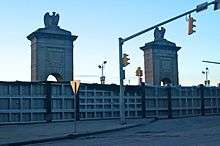
The River Common is located along the eastern bank of the Susquehanna River. The Market Street Bridge bisects the park. The River Common joins with the Luzerne County Courthouse grounds. Its features include a 750-person amphitheater, paved walk-ways, gardens, ornamental trees, seating areas, a fishing pier, and two grand gateways connecting the city to the river.
Demographics
| Historical population | |||
|---|---|---|---|
| Census | Pop. | %± | |
| 1800 | 835 | — | |
| 1810 | 1,225 | 46.7% | |
| 1820 | 755 | −38.4% | |
| 1840 | 1,718 | — | |
| 1850 | 2,723 | 58.5% | |
| 1860 | 4,253 | 56.2% | |
| 1870 | 10,174 | 139.2% | |
| 1880 | 23,339 | 129.4% | |
| 1890 | 37,718 | 61.6% | |
| 1900 | 51,721 | 37.1% | |
| 1910 | 67,105 | 29.7% | |
| 1920 | 73,833 | 10.0% | |
| 1930 | 86,626 | 17.3% | |
| 1940 | 86,236 | −0.5% | |
| 1950 | 76,826 | −10.9% | |
| 1960 | 63,068 | −17.9% | |
| 1970 | 58,856 | −6.7% | |
| 1980 | 51,551 | −12.4% | |
| 1990 | 47,523 | −7.8% | |
| 2000 | 43,123 | −9.3% | |
| 2010 | 41,498 | −3.8% | |
| Est. 2019 | 40,766 | [2] | −1.8% |
| U.S. Decennial Census[31] | |||

The city's population has been in constant decline since the 1930s. As of the 2010 census, the city was 79.2% White, 10.9% Black or African American, 0.3% Native American, 1.4% Asian, and 2.9% were two or more races. Of the population, 11.3% were of Hispanic or Latino ancestry.[32] The Hispanic population was just 1.58% of the population as of the 2000 census.
As of the 2000 census, there were 43,123 people, 17,961 households, and 9,878 families residing in the city. The population density was 6,296.3 people per square mile (2,430.6/km2). There were 20,294 housing units at an average density of 2,963.1 per square mile (1,143.9/km2). The racial makeup of the city was 92.30% White, 5.09% African American, 0.11% Native American, 0.79% Asian, 0.03% Pacific Islander, 0.53% from other races, and 1.15% from two or more races. Hispanic or Latino of any race were 1.58% of the population.
The average household size was 2.20, and the average family size was 2.96.
In the city, the population was spread out, with 19.9% under the age of 18, 12.6% from 18 to 24, 26.1% from 25 to 44, 20.8% from 45 to 64, and 20.6% who were 65 years of age or older. The median age was 39 years. For every 100 females, there were 93.2 males. For every 100 females (age 18 and over), there were 90.7 males.
Dialect
The local accent of American English is Northeast Pennsylvania English.
Religion
More than half (59.3%) of the city's population is religious: 43.8% Catholic, 4.4% Methodist, 3.1% Lutheran, 2.0% Presbyterian, 1.1% Pentecostal, 0.8% Judaism, 0.6% Episcopalian, 0.5% Baptist, 0.5% Islam, and 0.3% The Church of Jesus Christ of Latter-day Saints.[33]
Economy
As of March 2019, income per capita in Wilkes-Barre was $18,375, compared to the national average of $31,177. Household income was $32,484, compared to the national average of $57,652. Family median income was $42,782, compared to the national average of $70,850. The city's unemployment rate in March 2019 was 6.4%. Recent job growth was 0.8%.[34] 49% of jobs were in sales, office, administrative support, production, transportation, and material moving sectors. In 2016, 30.1% of residents lived below the poverty line, more than double the Pennsylvania average of 12.9%.[35] Large employers in the city include GUARD Insurance Group and Lord & Taylor.
Government
City government

Executive
The city is headed by an elected mayor, who serves four-year terms. The current mayor is George Brown (Democrat). He has been in office since 2019. Before becoming mayor he was a business man and a former city councilman.
Legislative
The legislative branch consists of a five-member City Council. They are elected by a single-member district to four-year terms. The following are current members of the council: Bill Barrett, Mike Belusko, Tony Brooks, Beth Gilbert, and Michael Merritt.
Audit and Control
The office of Audit and Control is the third branch of Wilkes-Barre City government. It is headed by the City Controller, elected to a four-year term. Darren G. Snyder, the current City Controller, is a Democrat and has been in office since 2016. The City Controller has the following powers and duties:
- Examine, audit, and verify all books, records, and accounts of the various administrative and legislative units, departments, offices, and officials under the control or supervision of the Mayor or Council, and for this purpose have access to all such books, records, and accounts at any time.
- Examine and approve for payment all contracts, purchase orders, and other documents by which the City incurs financial obligations, having ascertained before approval that monies have been duly appropriated or provided for, and allotted to meet such obligations.
- Audit and approve all bills, invoices, payrolls, and other evidence of claims, demands, or charges paid from City funds.
- Submit reports to the City Council and the Mayor of any records deemed in violation of law or contrary to accepted accounting procedures.
- Prepare and submit to Council and the Mayor within sixty (60) days of the end of every fiscal year a complete financial statement of the affairs of the City with such comments as the Controller deems appropriate.
- Employ a Deputy and/or other personnel essential to the accomplishment of his duties.
- Delegate any duty and/or responsibility to the Deputy Controller that he shall deem necessary.
- Audit Authorities of the City as he deems appropriate and not contrary to law.
Judicial
The City of Wilkes-Barre is served by two City Attorneys (Timothy Henry and Maureen Collins). They advise both the Mayor and City Council.
County government

The Luzerne County government operates out of Wilkes-Barre. The city is the administrative center of Luzerne County. The county government is responsible for imposing taxes, providing services to the public, and administering laws and regulations. They govern over a population of nearly 320,000 people. Many government offices are situated within the county courthouse (located at 200 North River Street in Downtown Wilkes-Barre). The Luzerne County Court of Common Pleas also operates out of the same building.
On November 2, 2010, the voters of Luzerne County held a referendum on the question of home rule. A total of 51,413 (55.25%) voted in favor of home rule, while another 41,639 (44.75%) voted against the move. This vote was the direct result of the corruption, wasteful spending, higher property taxes, and out-of-control debt facing the county.[36] The home rule charter took effect on January 2, 2012; the Luzerne County Board of Commissioners was abolished and replaced with the new form of government (council–manager government). This government consists of a county council. The council chair, who is appointed by his or her fellow council members, is both the highest-ranking officer on the assembly and the head of county government for ceremonial purposes.[37] The council also appoints and works alongside a full-time manager (who supervises the county's day-to-day operations).
The county government is also made up of many other officials (e.g., the county controller, district attorney, and sheriff).
State and federal representation
State
- Eddie Day Pashinski (D) represents Wilkes-Barre in the Pennsylvania House of Representatives.
- John Yudichak (I) represents the city in the Pennsylvania State Senate.
Federal
- Matthew Cartwright (D) represents Wilkes-Barre on the federal level (in the U.S. House of Representatives).
- Bob Casey (D) and Pat Toomey (R) represent the entire Commonwealth of Pennsylvania in the U.S. Senate.
Education


High schools
Wilkes-Barre City is part of the Wilkes-Barre Area School District. The district operates three high schools:
- James M. Coughlin High School
- G.A.R. (Grand Army of the Republic) Memorial High School
- Elmer L. Meyers High School
The Diocese of Scranton also has a high school in Wilkes-Barre—Holy Redeemer High School.
Colleges
The area in and around Wilkes-Barre consists of several colleges/universities:
Libraries
Along with the libraries associated with the colleges, Wilkes-Barre has several libraries. These include three branches of the Osterhout Free Library, with the headquarters for the Luzerne County Library System in the main branch.[38][39][40]
Infrastructure

Transportation
Airports
Five international airlines fly from the Wilkes-Barre/Scranton International Airport in nearby Pittston Township. Smaller, private planes may also use the Wilkes-Barre Wyoming Valley Airport in Forty Fort.
Highways
Interstate 81 passes north–south near Wilkes-Barre, and the city is also located near the Northeast Extension of the Pennsylvania Turnpike. It is also about 10 miles (16 km) north of Interstate 80. The North Cross Valley Expressway, starting at the junction of Interstate 81 and Pennsylvania Route 115, carries Pennsylvania Route 309 through northern Wilkes-Barre, connecting the city to Dallas in the north. Route 115 provides access from the Pennsylvania Turnpike's Northeast Extension, but it does not enter Wilkes-Barre city limits.
Buses
Public transportation is provided by the Luzerne County Transportation Authority. In addition to servicing the city, it provides transportation for the northern half of the county. It also has a connecting bus to Scranton via an interchange at Pittston with the Transit System of Lackawanna County (COLTS), the public transit authority of Lackawanna County. Martz Trailways provides intercity bus service from the Martz Trailways Bus Terminal in downtown Wilkes-Barre to Scranton, New York City, Philadelphia, Atlantic City, and Wind Creek Bethlehem.[41]
Rail
The city was at one time served by the Lehigh Valley Railroad, Central Railroad of New Jersey, the Delaware, Lackawanna and Western Railroad (later Erie Lackawanna Railway), Delaware and Hudson Railway, the Pennsylvania Railroad, the Wilkes-Barre and Eastern Railroad, and the Lackawanna and Wyoming Valley Railroad (known as the Laurel Line). CNJ trains included the Interstate Express (ending in 1957) and local service to Allentown and Philadelphia. The last Lehigh Valley trains were the Black Diamond (ending in 1959), John Wilkes and Maple Leaf (the last two, ending in 1961).
The Wilkes-Barre Traction Company formed a streetcar line from Georgetown to Nanticoke and over the river into Plymouth (it ceased operations in the mid-1940s).
Today, the Norfolk Southern Railway (which acquired the former Delaware and Hudson line from successor Canadian Pacific Railway) and the Luzerne and Susquehanna Railway (designated-operator of a county-owned shortline) provide freight service within the city.
Arts and culture

Local attractions
- Dorothy Dickson Darte Center for the Performing Arts, located on the campus of Wilkes University[42]
- F. M. Kirby Center for the Performing Arts[43]
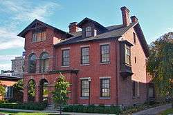
- Frederick Stegmaier Mansion[44]
- Little Theatre of Wilkes-Barre[45]
- Luzerne County Convention and Visitors Bureau
- Luzerne County Museum[46]
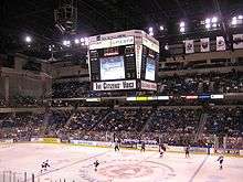
- Mohegan Sun Arena at Casey Plaza
- Mohegan Sun at Pocono Downs, Pennsylvania's first slots casino
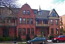
- River Street Historic District
- Stegmaier Brewery
- Wilkes-Barre station
- Wyoming Monument
Media
Times Leader and The Citizens' Voice are the two largest daily newspapers in Wilkes-Barre. The Wyoming Valley's NBC affiliate, WBRE-TV 28, is the only television station licensed to Wilkes-Barre, but WNEP-TV 16 (ABC), WYOU 22 (CBS), WVIA-TV 44 (PBS), and WSWB 38 (CW), all in Scranton, WOLF-TV 56 (Fox) in Hazleton, and WQMY 53 (MyNetworkTV) in Williamsport also serve the city. Wilkes-Barre's radio market is ranked No. 69 by Arbitron's ranking system. There are news, adult alternative, and music radio stations which are receivable in the area.
Popular culture
- Wilkes-Barre's economic plight is featured in the movie Capitalism: A Love Story, directed by Michael Moore.[47]
- The Wilkes-Barre variation (or Traxler variation, as it is more commonly known) of the Two Knights' Defense is named for the Wilkes-Barre chess club.[48]
- In the TV series Supernatural episode 8.13 "Everyone Hates Hitler," the lead protagonists investigate a case in Wilkes-Barre.[49][50]
Sports
| Club | League | Venue | Established | Parent Club | League Championships |
|---|---|---|---|---|---|
| Scranton/Wilkes-Barre RailRiders | IL, Baseball | PNC Field | 1989 | New York Yankees | 2 |
| Wilkes-Barre/Scranton Penguins | AHL, Ice hockey | Mohegan Sun Arena at Casey Plaza | 1999 | Pittsburgh Penguins | 0[51] |
Notable people
- Jane Alexander, lawyer and Pennsylvania state representative
- Hazel Barnes, philosopher
- Douglas Carter Beane, playwright[52]
- Al Bedner, NFL player
- David Bohm, quantum physicist
- Benjamin Burnley, lead singer and guitarist for rock band Breaking Benjamin
- Lillian Cahn, co-founder of Coach, Inc. and Coach handbag designer[53]
- George Catlin, artist
- Britton Chance, bio-physicist and Olympic sailor
- Catherine Chandler, poet
- Mark Ciavarella, disgraced judge in kids for cash scandal
- Mark Cohen, street photographer
- Colleen Corby, 1960s fashion model[54]
- Mary Helen Peck Crane (1827–1891), activist, writer; mother of Stephen Crane
- Amasa Dana, former U.S. Congressman
- Charles B. Dougherty, Army National Guard major general who commanded the 28th Infantry Division
- Mark Duda, NFL player, Lackawanna College football head coach
- Francis A. "Mother" Dunn, football player for the Canton Bulldogs
- Dave Edivitch, Hollywood filmmaker most known for the movie The Sandlot
- Jesse Fell, early experimenter with anthracite coal
- Pat Finn, game show host whose shows include Lifetime's, The Family Channel's, and PAX's Shop 'til You Drop
- Ham Fisher, cartoonist
- Tess Gardella, actress
- William Harmatz, jockey, winner of 1959 Preakness Stakes
- Laning Harvey, Pennsylvania state senator
- George Washington Helme, businessman and founder of Helmetta, New Jersey
- Joe Hergert, former professional football player
- William Henry Hines, U.S. Representative for Pennsylvania's 12th congressional district from 1893-1895
- Raye Hollitt, bodybuilder and actress
- Qadry Ismail, former NFL wide receiver on the Baltimore Ravens
- Raghib Ismail, former NFL player and Heisman Trophy runner-up
- Florence Foster Jenkins, unconventional operatic soprano, subject of film starring Meryl Streep
- Candy Jones, fashion model, writer, radio personality[55]
- Dorothy Andrews Elston Kabis, Treasurer of the United States
- James Karen, actor
- Mary Holland Kinkaid, journalist
- Michael J. Kirwan, represented Youngstown, Ohio in Congress, 1938–1970
- Franz Kline, abstract expressionist painter
- Mike Konnick, former MLB player
- Mary Jo Kopechne, passenger killed in car driven by Ted Kennedy at Chappaquidick
- Harley Jane Kozak, actress and author
- Matthew Lesko, infomercial personality
- Edward B. Lewis, winner of the 1995 Nobel Prize in physiology and medicine
- Santo Loquasto, production designer
- Garrick Mallery, ethnologist
- Herman Mankiewicz, screenwriter of Citizen Kane
- Joseph L. Mankiewicz, Academy Award-winning director and producer
- Al Markim, actor (Tom Corbett, Space Cadet)[56]
- Mary McDonnell, actress twice nominated for Academy Award
- Edward Peter McManaman, Roman Catholic bishop
- Edward Meneeley, painter
- Albert Mudrian, author and magazine editor
- Leo C. Mundy, Pennsylvania state senator and physician
- Jozef Murgas, radio pioneer
- Claudette Nevins, actress
- Amedeo Obici, founder of Planters Peanuts
- Rose O'Neill, cartoonist, illustrator, artist, and writer.
- Jerry Orbach, Tony award-winning actor
- Phil Ostrowski, NFL player
- John Paluck, football player for Washington Redskins and Pro Bowl selection
- William Daniel Phillips, co-recipient of the 1997 Nobel Prize in Physics
- Mendy Rudolph, NBA referee from 1953 to 1975
- Sam Savitt, equestrian artist, author
- Michael Schoeffling, actor, played Jake Ryan in film Sixteen Candles
- Don Schwall, MLB pitcher
- M. Gerald Schwartzbach, California criminal defense attorney[57]
- Greg Skrepenak, former NFL player, convicted felon
- Jonathan Slavin, character actor
- Ron Solt, former NFL player
- Jacob Sullum, journalist and author, featured in Academy Award-nominated documentary Super Size Me[58]
- Bob Sura, basketball player, Houston Rockets
- Louis Teicher, pianist; member of the duo Ferrante & Teicher
- Alexis Toth (St. Alexis of Wilkes-Barre), saint in the Eastern Orthodox Church
- John Walsh, MLB third baseman
- Michael Whalen, actor
- Ira W. Wood, represented New Jersey's 4th congressional district from 1904 to 1913[59]
- Tom Woodeshick, professional football player[60]
- Frank Zane, bodybuilder, three-time Mr. Olympia, won Mr. America, Mr. Universe, Mr. World; donated gym at Wilkes University
See also
Notes
- Mean monthly maxima and minima (i.e. the expected highest and lowest temperature readings at any point during the year or given month) calculated based on data at said location from 1981 to 2010.
- Official records for Avoca/Wilkes-Barre–Scranton kept at downtown Scranton from January 1901 to 17 April 1955 and at Wilkes-Barre/Scranton International Airport since 18 April 1955.[28]
References
- "2017 U.S. Gazetteer Files". United States Census Bureau. Retrieved March 24, 2019.
- "Population and Housing Unit Estimates". Retrieved May 21, 2020.<
- "ZIP Code(tm) Lookup". United States Postal Service. Retrieved December 17, 2014.
- "City of Wilkes Barre, PA Zip Codes". Retrieved December 17, 2014.
- "Early Wilkes-Barre, Luzerne Co., Pa". www.pagenweb.org. Retrieved October 10, 2018.
- "History – Kingston Borough". kingstonpa.org.
- 1769 The Pennamite Wars, The Society of Colonial Wars in Connecticut. Accessed March 26, 2017.
- ""A History of Wilkes-Barre, Luzerne County, Pennsylvania" Page 14, 1909". Mocavo.com. April 2, 2013. Retrieved May 12, 2014.
- Federal Writers' Project (1940). Pennsylvania: A Guide to the Keystone State (1st ed.). New York: Oxford University Press. p. 336.
- Pennsylvania Historical Society
- US Department of Commerce, NOAA. "August 19, 1890 Wilkes Barre Tornado". www.weather.gov.
- Troncale, Anthony T. "About Lewis Wickes Hine". New York Public Library. Archived from the original on March 8, 2007. Retrieved May 22, 2007.
- "Knox Mine Disaster". www.pagenweb.org. Retrieved October 10, 2018.
- Staff. "14 things you didn't know about Mr. Peanut as he heads to Mechanicsburg", The Patriot-News, July 13, 2016. Accessed March 26, 2017. "Amedeo Obici, along with his friend and business partner, Mario Peruzzi, founded Planters Peanut Co. in Wilkes-Barre in 1906."
- "Scranton/Wilkes-Barre Yankees". Minorleaguebaseball.com. October 12, 1926. Retrieved June 24, 2010.
- Nissley, Erin L. "Local History: NEPA put HBO on the dial", The Scranton Times-Tribune, November 3, 2013. Accessed March 26, 2017. "Home Box Office, known more commonly as HBO, got its start in 1972 with about 365 subscribers in Wilkes-Barre. It was the channel's first affiliation."
- Lipman, Don (June 21, 2012). "Hurricane Agnes: A look back after 40 years".
- "Retrospective: The Damage Caused by Hurricane Agnes – Washingtonian". June 19, 2012.
- Skrapits, Eizabeth. "Four years later, levee system standing tall", The Citizens' Voice, September 9, 2015. Accessed March 27, 2017. "The levee was officially completed on Jan. 14, 2003. The cost totaled more than $250 million. Belleman said the system was designed for an Agnes-level flood of 41 feet, but it held up under the larger Tropical Storm Lee flood."
- Staff. " Levees hold Susquehanna; Delaware River rages; Wilkes-Barre evacuees head back home; death toll rises", CNN, June 29, 2006. Accessed March 27, 2007. "The news was better in northeastern Pennsylvania, where a mandatory evacuation affecting up to 200,000 people in Wilkes-Barre and a nearby valley area was lifted.Officials said the city's $175 million levee system held back the rising Susquehanna River despite floods caused by overflowing tributaries and creeks, and rain that averaged a half-inch an hour in some areas."
- "Advanced Hydrologic Prediction Service for the Susquehanna River at Wilkes-Barre". NOAA National Weather Service. Retrieved September 9, 2011.
- "W-B intermodal center opens today". Citizens Voice. July 6, 2010. Retrieved August 16, 2011.
- "Developer presents plans for former Hotel Sterling site - Times Leader". timesleader.com. March 20, 2018. Retrieved October 10, 2018.
- "Station Name: PA WILKES-BARRE INTL AP". National Oceanic and Atmospheric Administration. Retrieved September 11, 2016.
- "Local Climatological Data–Annual Summary with Comparative Data: Wilkes–Barre/Scranton" (PDF). National Oceanic and Atmospheric Administration. Retrieved September 30, 2015.
- "NowData - NOAA Online Weather Data". National Oceanic and Atmospheric Administration. Retrieved February 25, 2017.
- "NOAA". NOAA.
- ThreadEx
- "Wilkes-Barre River Common". Tour NEPA. Luzerne County Convention and Visitors Bureau. Retrieved December 17, 2014.
- "Resident Services". Wilkes-barre.pa.us. Archived from the original on April 8, 2014. Retrieved May 12, 2014.
- United States Census Bureau. "Census of Population and Housing". Retrieved November 19, 2013.
- "Census 2010: Pennsylvania". USA Today. Retrieved December 6, 2011.
- "Wilkes-Barre, Pennsylvania Religion".
- "Wilkes-Barre, Pennsylvania Economy". www.bestplaces.net. Retrieved July 15, 2019.
- "Wilkes-Barre, Pennsylvania (PA) poverty rate data - information about poor and low income residents living in this city". www.city-data.com. 2016.
- "Election Results Archive". Luzerne County. Archived from the original on January 11, 2018. Retrieved June 19, 2018.
- "Home Rule Charter". Luzerne County. Archived from the original on February 4, 2018. Retrieved June 19, 2018.
- "Locations & Hours – Osterhout Free Library". Osterhout Free Library. Retrieved January 25, 2018.
- "Luzerne County Libraries". www.luzernelibraries.org. Retrieved January 25, 2018.
- "About the Luzerne County Library System". www.luzernelibraries.org. Retrieved January 25, 2018.
- "Daily Passenger Service Schedules" (PDF). Martz Group. Retrieved October 16, 2017.
- "Wilkes Division of Performing Arts". Wilkes University. Archived from the original on April 1, 2014. Retrieved May 12, 2014.
- "The F.M. Kirby Center for the Performing Arts". Kirbycenter.org. Retrieved May 12, 2014.
- "The Frederick Stegmaier Mansion". Stegmaiermansion.com. May 26, 2011. Retrieved May 12, 2014.
- "Little Theatre of Wilkes-Barre". Ltwb.org. Retrieved May 12, 2014.
- Luzerne County Historical Society. "Welcome to the Luzerne County Historical Society website | NEPA Luzerne County Pennsylvania history". Luzernehistory.org. Retrieved May 12, 2014.
- "Capitalism: A Love Story – facts". Michaelmoore.com. Archived from the original on November 29, 2011. Retrieved December 6, 2011.
- "Alex Dunne May 1998". uschess.org. Retrieved September 13, 2014.
- "8.13 Everybody Hates Hitler". supernaturalwiki.com.
- "A Golem on Supernatural". Congregation Rodfei Zedek. June 9, 2013.
- "脱毛は、自宅でも簡単にできる! 脇、手足、ビキニラインも!". wbslacrosse.com. Retrieved September 13, 2014.
- "Douglas Carter Beane: Interview". Oasis Journals. February 20, 2007. Archived from the original on January 12, 2012. Retrieved December 6, 2011.
- Vitello, Paul (March 7, 2013). "Lillian Cahn, Creator of the Coach Handbag, Dies at 89". The New York Times. Retrieved April 2, 2013.
- Kahn, S. "Modeling: Money and Madness!", Teen, December 1963
- Flint, Peter B. "Candy Jones Dies; Ex-Model, Teacher, And Writer Was 64", The New York Times, January 19, 1990. Retrieved December 20, 2007.
- Barnes, Mike (November 27, 2015). "Al Markim, Actor on the 1950s TV Serial 'Tom Corbett, Space Cadet,' Dies at 88". The Hollywood Reporter. Retrieved December 22, 2015.
- Andrew Blankstein (March 28, 2005). "Attorney Makes Mark by Taking Cases That Others Avoid". Los Angeles Times.
- Sullum, Jacob (2011-01-04) First Wine, Now Beer in (Some) Pennsylvania Supermarkets; Coming Soon: Cats and Dogs Living Together, Reason
- Ira Wells Wood, Biographical Directory of the United States Congress. Retrieved September 6, 2007.
- "Tom Woodeshick". NFL Enterprises. Retrieved November 23, 2017.
External links
| Wikimedia Commons has media related to Wilkes-Barre, Pennsylvania. |
| Wikivoyage has a travel guide for Wilkes-Barre. |
Places adjacent to Wilkes-Barre, Pennsylvania | ||||||||||
|---|---|---|---|---|---|---|---|---|---|---|
| ||||||||||

| Authority control |
|
|---|