Mifflintown, Pennsylvania
Mifflintown is a borough in and the county seat of Juniata County, Pennsylvania, United States.[4] The population was 936 at the 2010 census.
Mifflintown, Pennsylvania | |
|---|---|
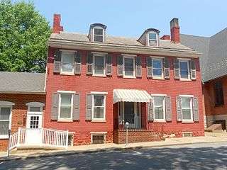
 Westminster Presbyterian Church | |
 Location of Mifflintown in Juniata County, Pennsylvania. | |
 Mifflintown Location of Mifflintown in Juniata County, Pennsylvania.  Mifflintown Mifflintown (the United States) | |
| Coordinates: 40°34′15″N 77°23′44″W | |
| Country | United States |
| State | Pennsylvania |
| County | Juniata |
| Settled | 1790 |
| Incorporated | 1833 |
| Area | |
| • Total | 0.14 sq mi (0.36 km2) |
| • Land | 0.14 sq mi (0.36 km2) |
| • Water | 0.00 sq mi (0.00 km2) |
| Elevation [2] (center of borough) | 469 ft (143 m) |
| Highest elevation [2] (northeastn boundary of borough) | 580 ft (180 m) |
| Lowest elevation [2] (Juniata River) | 418 ft (127 m) |
| Population (2010) | |
| • Total | 936 |
| • Estimate (2018)[3] | 912 |
| • Density | 6,521.43/sq mi (2,516.04/km2) |
| Time zone | UTC-5 (Eastern (EST)) |
| • Summer (DST) | UTC-4 (EDT) |
| Zip code | 17059 |
| Area code(s) | 717 Exchange: 436 |
| FIPS code | 42-49304 |
| Website | Mifflintown Borough website |
Geography
Mifflintown is located at 40°34′15″N 77°23′44″W (40.570728, -77.395488).[5]
According to the United States Census Bureau, the borough has a total area of 0.1 square miles (0.26 km2), all of it being land.
Demographics
| Historical population | |||
|---|---|---|---|
| Census | Pop. | %± | |
| 1850 | 485 | — | |
| 1860 | 767 | 58.1% | |
| 1870 | 857 | 11.7% | |
| 1880 | 842 | −1.8% | |
| 1890 | 877 | 4.2% | |
| 1900 | 953 | 8.7% | |
| 1910 | 954 | 0.1% | |
| 1920 | 1,083 | 13.5% | |
| 1930 | 1,027 | −5.2% | |
| 1940 | 1,097 | 6.8% | |
| 1950 | 1,013 | −7.7% | |
| 1960 | 887 | −12.4% | |
| 1970 | 828 | −6.7% | |
| 1980 | 783 | −5.4% | |
| 1990 | 866 | 10.6% | |
| 2000 | 861 | −0.6% | |
| 2010 | 936 | 8.7% | |
| Est. 2018 | 912 | [3] | −2.6% |
| Sources:[6][7][8] | |||
As of the census[7] of 2000, there were 861 people, 372 households, and 210 families residing in the borough. The population density was 6,184.9 people per square mile (2,374.5/km²). There were 395 housing units at an average density of 2,837.4 per square mile (1,089.4/km²). The racial makeup of the borough was 93.96% White, 0.23% Native American, 0.23% Asian, 3.72% Pacific Islander, 1.39% from other races, and 0.46% from two or more races. Hispanic or Latino of any race were 8.71% of the population.
There were 372 households, out of which 28.0% had children under the age of 18 living with them, 40.3% were married couples living together, 12.9% had a female householder with no husband present, and 43.5% were non-families. 38.7% of all households were made up of individuals, and 18.8% had someone living alone who was 65 years of age or older. The average household size was 2.24 and the average family size was 2.97.
In the borough the population was spread out, with 25.2% under the age of 18, 8.5% from 18 to 24, 30.3% from 25 to 44, 20.9% from 45 to 64, and 15.1% who were 65 years of age or older. The median age was 36 years. For every 100 females there were 96.6 males. For every 100 females age 18 and over, there were 92.8 males.
The median income for a household in the borough was $28,125, and the median income for a family was $33,594. Males had a median income of $26,563 versus $20,125 for females. The per capita income for the borough was $14,394. About 10.7% of families and 13.7% of the population were below the poverty line, including 18.1% of those under age 18 and 17.0% of those age 65 or over.
There is a large Amish and Mennonite population around the borough.
 House near the courthouse
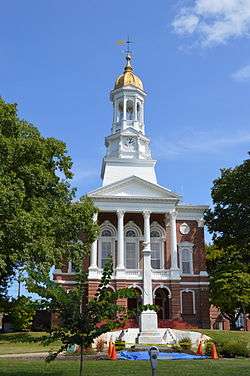 Juniata County Courthouse
 Building on Bridge Street
Business
As the county seat of Juniata County, Mifflintown serves as the county's center of business and government. Given the borough's small size, as well as the county's small population, the presence of business and government remain limited. The Mifflintown borough boundaries limit the size of the community, meaning that retail and business functions necessarily spill over onto land of bordering municipalities.
Nevertheless, Mifflintown serves as the corporate headquarters of both The Juniata Valley Bank and Pennian Bank. Empire Kosher Poultry, the nation's largest producer of kosher poultry, has both its headquarters and processing facility in adjoining Fermanagh Township.
Land surrounding Mifflintown serves as Juniata County's retail center as well, hosting Weis Markets, Family Dollar, Dollar General, and numerous smaller shops like Two Sisters and Mac's Clothing, gas stations, restaurants, including Sheetz, Rutter’s Farm Stores, and Mifflintown Mart.
Transportation
._loc_call_no_g3824m-pm008027.jpg)
Pennsylvania Route 35, a southwest-northeast highway that serves as Juniata County's principal arterial highway running in that direction, forms the main street of Mifflintown. It intersects the former mainline of US routes 22 and 322, which was moved in the early 1970s to a four-lane bypass lying east of the town. The former Pennsylvania Railroad mainline tracks, now owned by the Norfolk Southern Railway, lie across the Juniata River in the adjoining town of Mifflin.
Education
Mifflintown is the home of Juniata High School, which serves the southern half of Juniata County. Tuscarora Junior High School and Juniata Elementary School are also located in the town.
See also
- Impact of the 2019–20 coronavirus pandemic on the meat industry in the United States
References
- "2017 U.S. Gazetteer Files". United States Census Bureau. Retrieved Mar 24, 2019.
- "Mifflintown Topo Map, Juniata County PA (Mifflintown Area)". TopoZone. Locality, LLC. Retrieved 26 November 2019.
- "Population and Housing Unit Estimates". Retrieved February 23, 2020.
- "Find a County". National Association of Counties. Retrieved 2011-06-07.
- "US Gazetteer files: 2010, 2000, and 1990". United States Census Bureau. 2011-02-12. Retrieved 2011-04-23.
- "Census of Population and Housing". U.S. Census Bureau. Retrieved 11 December 2013.
- "U.S. Census website". United States Census Bureau. Retrieved 2008-01-31.
- "Incorporated Places and Minor Civil Divisions Datasets: Subcounty Resident Population Estimates: April 1, 2010 to July 1, 2012". Population Estimates. U.S. Census Bureau. Retrieved 11 December 2013.
External links
![]()
Municipalities and communities of Juniata County, Pennsylvania, United States | ||
|---|---|---|
| Boroughs | 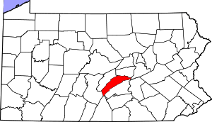 | |
| Townships | ||
| CDPs | ||
| Unincorporated communities | ||
| Footnotes | ‡This populated place also has portions in an adjacent county or counties. | |
| Authority control |
|
|---|