Erie County, Pennsylvania
Erie County is a county located in the U.S. state of Pennsylvania. As of the 2019 estimates, the population was 269,728.[1] Its county seat is Erie.[2] The county was created in 1800 and later organized in 1803.[3]
Erie County | |
|---|---|
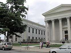 Erie County Courthouse | |
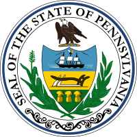
 Seal | |
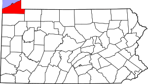 Location within the U.S. state of Pennsylvania | |
 Pennsylvania's location within the U.S. | |
| Coordinates: 42°06′N 80°06′W | |
| Country | |
| State | |
| Founded | November 7, 1803 |
| Named for | Lake Erie |
| Seat | Erie |
| Largest city | Erie |
| Area | |
| • Total | 1,558 sq mi (4,040 km2) |
| • Land | 799 sq mi (2,070 km2) |
| • Water | 759 sq mi (1,970 km2) 49%% |
| Population | |
| • Estimate (2019) | 269,728 |
| • Density | 341/sq mi (132/km2) |
| Time zone | UTC−5 (Eastern) |
| • Summer (DST) | UTC−4 (EDT) |
| Congressional district | 16th |
| Website | www |
Erie County comprises the Erie, PA Metropolitan Statistical Area.
History
Erie County was established on March 12, 1800, from part of Allegheny County, which absorbed the lands of the disputed Erie Triangle in 1792. Prior to 1792, the region was claimed by both New York and Pennsylvania and so no county demarcations were made until the federal government intervened.[4]
Since Erie County and its newly established neighboring Counties of Crawford, Mercer, Venango, and Warren were initially unable to sustain themselves, a five-county administrative organization was established at Crawford County's Meadville to temporarily manage government affairs in the region. Erie first elected its own county officials in 1803.[5] Unfortunately, on March 23, 1823, the Erie County Courthouse burned and all county records to that point were destroyed.[6]
The county was originally settled by immigrants of "Yankee" stock (immigrants from New England and the western part of New York descended from the English Puritans whose ancestors settled New England in the colonial era). Erie County resembled Upstate New York more than it did Pennsylvania with its population primarily consisting of settlers from Connecticut, Rhode Island and Maine.[7] Roads were laid out, post routes established, public buildings erected and people were invited to move there. The original settlers were entirely of New England origins or were Yankees from upstate New York whose families had moved to that place from New England only one generation earlier, in the aftermath of the Revolutionary War. This resulted in Erie County being culturally very contiguous with early New England culture.
Erie County was part of the Underground Railroad giving slaves the ability to gain freedom through Lake Erie into Canada, East through New York State, or to stay in Erie with the help of abolitionists and the free black community. Today, the "Journey to Freedom" educational program provides an interactive program on the Underground Railroad experience.[8]
Geography
According to the U.S. Census Bureau, the county has a total area of 1,558 square miles (4,040 km2), of which 799 square miles (2,070 km2) is land and 759 square miles (1,970 km2) (49%) is water.[9] It is the largest county in Pennsylvania by total area. With the exception of a high ridge several miles from the lake, running nearly parallel with its shore, the terrain is generally rolling and well watered.[10] It is the only county in the state that occupies a significant amount of land north of the 42nd parallel.
There are two cities in Erie County: the city of Erie and the city of Corry. Other notable population centers include Millcreek, Harborcreek and Fairview townships, and the boroughs of Edinboro, North East, Girard, Waterford and Union City. Erie County is bordered on the northeast by Chautauqua County, New York, on the east by Warren County, on the south by Crawford County, and on the west by Ashtabula County, Ohio. Directly north of the county is Lake Erie. This position on the water makes Erie County the only county in Pennsylvania to share a border with Canada, which is located on the far shore of the lake.
The county has a warm-summer humid continental climate (Dfb). Average monthly temperatures in downtown Erie range from 26.4° F in January to 70.8° F in July, while in Corry they range from 23.8° F in January to 68.2° F in July.
Adjacent counties
- Haldimand County, Ontario (north)
- Norfolk County, Ontario (northwest)
- Chautauqua County, New York (northeast)
- Warren County (southeast)
- Crawford County (south)
- Ashtabula County, Ohio (southwest)
Demographics
| Historical population | |||
|---|---|---|---|
| Census | Pop. | %± | |
| 1800 | 1,468 | — | |
| 1810 | 3,758 | 156.0% | |
| 1820 | 8,553 | 127.6% | |
| 1830 | 17,041 | 99.2% | |
| 1840 | 31,344 | 83.9% | |
| 1850 | 38,742 | 23.6% | |
| 1860 | 49,432 | 27.6% | |
| 1870 | 65,973 | 33.5% | |
| 1880 | 74,688 | 13.2% | |
| 1890 | 86,074 | 15.2% | |
| 1900 | 98,473 | 14.4% | |
| 1910 | 115,517 | 17.3% | |
| 1920 | 153,536 | 32.9% | |
| 1930 | 175,277 | 14.2% | |
| 1940 | 180,889 | 3.2% | |
| 1950 | 219,388 | 21.3% | |
| 1960 | 250,682 | 14.3% | |
| 1970 | 263,654 | 5.2% | |
| 1980 | 279,780 | 6.1% | |
| 1990 | 275,572 | −1.5% | |
| 2000 | 280,845 | 1.9% | |
| 2010 | 280,566 | −0.1% | |
| Est. 2019 | 269,728 | [11] | −3.9% |
| U.S. Decennial Census[12] 1790-1960[13] 1900–1990[14] 1990-2000[15] 2010–2019[1] | |||
According to the 2010 census, there were 280,566 people, 110,413 households, and 70,196 families residing in the county. The population density was 351.2 inhabitants per square mile (135.6/km2). There were 119,138 housing units at an average density of 149.1 per square mile (57.6/km2). The racial makeup of the county was 88.2 percent White, 7.2 percent Black or African American, 0.2 percent Native American, 1.1 percent Asian, 0.03 percent Pacific Islander, 1.2 percent from other races, and 2.1 percent from two or more races. A further 3.4 percent of the population were Hispanic or Latino of any race. 24.4% were of German, 12.5% Polish, 12.3% Italian, 10.1% Irish, 6.5% English and 6.4% American ancestry.
Of the total number of household, 27.2 percent had children under the age of 18 living with them, 45.4 percent were married couples living together, 13.2 percent had a female householder with no husband present, and 36.4 percent were non-families. 29.3 percent of all households were made up of individuals and 11.3 percent had someone living alone who was 65 years of age or older. The average household size was 2.42 and the average family size was 3.00.
In the county, the population was spread out with 26.5 percent under the age of 20. The median age was 38.6 years. For every 100 females there were 96.73 males.
Metropolitan Statistical Area

The United States Office of Management and Budget[16] has designated Erie County as the Erie, PA Metropolitan Statistical Area (MSA). As of the 2010 U.S. Census[17] the metropolitan area ranked 11th most populous in the State of Pennsylvania and the 164th most populous in the United States with a population of 280,566. Erie County is also a part of the larger Erie-Meadville, PA Combined Statistical Area (CSA), which combines the populations of Erie County as well as Crawford County to the south. The Combined Statistical Area ranked 7th in the State of Pennsylvania and 102nd most populous in the United States with a population of 369,331.
Largest populations in Erie County
| 2015 rank | City | Type | 2016 estimate | 2010 Census | Change | Highest Population (Year) |
|---|---|---|---|---|---|---|
| 1 | Erie | City | 98,593 | 101,786 | −3.14% | 138,440 (1960) |
| 2 | Millcreek | Township | 53,773 | 53,515 | +0.48% | 54,256 (2013) |
| 3 | Harborcreek | Township | 17,517 | 17,234 | +1.64% | 17,629 (2014) |
| 4 | Fairview | Township | 10,150 | 10,102 | +0.48% | 10,217 (2013) |
| 5 | Summit | Township | 6,916 | 6,603 | +4.74% | 6,916 (2016) |
| 6 | Corry | City | 6,360 | 6,605 | −3.71% | 7,911 (1950) |
| 7 | North East | Township | 6,269 | 6,315 | −0.73% | 7,702 (2000) |
| 8 | Edinboro | Borough | 6,236 | 6,438 | −3.14% | 7,736 (1990) |
Government and politics
Prior to 1960, Erie County was primarily Republican in presidential elections, only backing Democratic Party candidates in four elections from 1888 to 1956. Since 1960, it has become primarily Democratic, with only four Republican wins in the county in presidential elections from 1960 to the present.
| Year | Republican | Democratic | Third parties |
|---|---|---|---|
| 2016 | 48.0% 60,069 | 46.4% 58,112 | 5.6% 6,948 |
| 2012 | 41.2% 49,025 | 57.1% 68,036 | 1.7% 2,053 |
| 2008 | 39.3% 50,351 | 59.1% 75,775 | 1.7% 2,145 |
| 2004 | 45.6% 57,372 | 54.0% 67,921 | 0.5% 605 |
| 2000 | 43.6% 49,027 | 52.9% 59,399 | 3.5% 3,909 |
| 1996 | 36.7% 39,884 | 52.9% 57,508 | 10.5% 11,399 |
| 1992 | 33.4% 39,283 | 47.9% 56,381 | 18.8% 22,140 |
| 1988 | 46.8% 48,306 | 52.2% 53,913 | 1.1% 1,081 |
| 1984 | 51.1% 55,860 | 48.0% 52,471 | 0.9% 935 |
| 1980 | 47.4% 48,918 | 44.5% 45,946 | 8.0% 8,298 |
| 1976 | 46.2% 49,641 | 51.6% 55,385 | 2.3% 2,413 |
| 1972 | 58.2% 61,542 | 39.8% 42,022 | 2.0% 2,149 |
| 1968 | 43.2% 43,134 | 51.7% 51,604 | 5.1% 5,109 |
| 1964 | 29.9% 31,393 | 69.6% 72,944 | 0.5% 549 |
| 1960 | 48.8% 51,525 | 50.9% 53,723 | 0.3% 295 |
| 1956 | 61.5% 54,430 | 38.2% 33,802 | 0.4% 323 |
| 1952 | 56.9% 48,836 | 42.7% 36,619 | 0.5% 391 |
| 1948 | 53.5% 33,806 | 44.5% 28,159 | 2.0% 1,280 |
| 1944 | 51.4% 35,247 | 48.0% 32,912 | 0.6% 419 |
| 1940 | 53.3% 36,608 | 46.2% 31,735 | 0.5% 371 |
| 1936 | 39.2% 25,607 | 50.6% 33,042 | 10.3% 6,706 |
| 1932 | 45.4% 18,371 | 48.4% 19,592 | 6.1% 2,479 |
| 1928 | 61.0% 30,542 | 38.5% 19,278 | 0.6% 277 |
| 1924 | 61.3% 19,480 | 11.0% 3,502 | 27.7% 8,802 |
| 1920 | 63.7% 19,465 | 20.7% 6,311 | 15.7% 4,793 |
| 1916 | 43.3% 8,933 | 46.7% 9,641 | 10.0% 2,056 |
| 1912 | 26.9% 4,958 | 30.6% 5,633 | 42.5% 7,817[19] |
| 1908 | 55.8% 10,828 | 31.8% 6,173 | 12.5% 2,418 |
| 1904 | 62.8% 11,951 | 26.9% 5,119 | 10.2% 1,948 |
| 1900 | 58.5% 11,816 | 36.0% 7,281 | 5.5% 1,110 |
| 1896 | 54.7% 11,819 | 42.7% 9,210 | 2.6% 563 |
| 1892 | 49.8% 8,918 | 42.3% 7,589 | 7.9% 1,416 |
| 1888 | 54.2% 9,372 | 41.2% 7,111 | 4.6% 798 |
The county seat of government is in Erie, Pennsylvania. The county has a home-rule charter and is run by a county executive. The current County Executive is Kathy Dahlkemper. Dahlkemper assumed the office in January 2014 after ousting incumbent Barry Grossman in the 2013 Democratic primary and defeating Republican Don Tucci in the general election. The remaining elected officials of the executive branch are the Erie County Controller, Erie County Coroner, Erie County District Attorney, Erie County Sheriff, and Erie County Clerk. see latest list
| Name | Party | Term start | Term end |
|---|---|---|---|
| Russell Robison | Republican | 1978 | 1982 |
| Judith M. Lynch | Democratic | 1982 | 2002 |
| Richard Schenker | Republican | 2002 | 2006 |
| Mark A. DiVecchio | Democratic | 2006 | 2010 |
| Barry Grossman | Democratic | 2010 | 2014 |
| Kathleen Dahlkemper | Democratic | 2014 | Incumbent |
County Legislature
The legislature consists of a county council. The Erie County Council is made up of seven councilpersons elected to represent seven geographical districts. see map A chair and vice chair are chosen among the councilpersons to lead the council.
- Kathy Fatica, Democratic (District 1 – west city)
- Andre Horton, Democratic (District 2 – city lakefront)
- Fiore Leone, Democratic (District 3 – south central city)
- Carl Anderson III, Democratic (Chair, District 4 – southeast city, suburbs)
- Kyle W. Foust, Democratic (Vice Chair, District 5 – northeast suburbs)
- Scott Rastetter, Republican (District 6 – southeast suburbs)
- Carol J. Loll, Republican (District 7 – west suburbs)
Judiciary
The judiciary is made up of nine judges serving the Erie County Court of Common Pleas and fifteen magisterial district judges serve the district courts. Court administration is managed by a district court administrator, deputy court administrator, and assistant court administrator. The Erie County Courthouse is located near Perry Square in downtown Erie. Erie County also operates a County Prison, and a combined 911/Emergency Management Agency under the Erie County Department of Public Safety, which is located in Summit Township.
Row officers
- Clerk of Records, Kenneth Gamble, Democratic (Was appointed after the retirement of Pat Fetzner in 2015[20])
- Controller, Dr. Kyle W. Foust, Democrat
- Coroner, Lyell Cook, Republican
- District Attorney, Jack Daneri, Republican
- Sheriff, John Loomis, Democratic
Politics
As of December 2019, there are 193,270 registered voters in Erie County.[21]
- Democratic: 96,825 (50.10%)
- Republican: 69,139 (35.77%)
- Other parties and non-affiliated: 27,306 (14.13%)
Unlike most of northwestern Pennsylvania, Erie County tends to be Democratic-leaning in statewide and national elections. All four statewide winners carried the county in 2008. The margins of victory for the Democratic Presidential candidate in the 2000, 2004, and 2008 elections in Erie County were 9, 8, and 20 percentage points, respectively. In 2016, however, Republican Donald Trump continued a trend seen elsewhere in the region, turning Erie County red. He was also the first Republican presidential candidate to carry Erie County since 1984.
State Senate
State House of Representatives
- Patrick J. Harkins (D), Pennsylvania's 1st Representative District
- Robert Merski (D), Pennsylvania's 2nd Representative District
- Ryan A. Bizzarro (D), Pennsylvania's 3rd Representative District
- Curtis G. Sonney (R), Pennsylvania's 4th Representative District
- Brad Roae (R), Pennsylvania's 6th Representative District
- Parke Wentling (R), Pennsylvania's 17th Representative District
United States House of Representatives
- Mike Kelly (R), Pennsylvania's 16th congressional district
United States Senate
- Pat Toomey, Republican
- Bob Casey, Democrat
Education
Public school districts
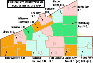
- Corry Area School District
- Erie City School District
- Fairview School District
- Fort LeBoeuf School District
- General McLane School District
- Girard School District
- Harbor Creek School District
- Iroquois School District
- Millcreek Township School District
- North East School District
- Northwestern School District
- Union City Area School District
- Wattsburg Area School District
Approved private schools
The Commonwealth of Pennsylvania has 36 Approved Private Schools including the Charter Schools for the Blind and Deaf. Students attending these schools come from across the commonwealth. The private schools are licensed by the State Board of Private Academic Schools. They provide a free appropriate special education for students with severe disabilities. The cost of tuition for these schools is paid 60% by the state and 40% by the local school district where the student is a resident. Pennsylvania currently has four PA chartered and 30 non-charter APSs for which the Department approves funding. These schools provide a program of special education for over 4,000 day and residential students. Parents are not charged for the services at the school.[22] In 2009, the Pennsylvania Department of Education budgeted $98 million for tuition of children in approved private schools and $36.8 million for students attending the charter schools for the deaf and blind.[23]
Community College
After years of advocacy on the issue, Erie County Council approved sponsorship of an Erie County Community College on June 28th, 2017. Council Chairman Jay Breneman and colleagues Andre Horton, Kathy Fatica and Fiore Leone voted in favor of sponsoring the community college, which was later signed by County Executive Kathy Dahlkemper. The County Executive's administration took the lead in presenting the proposal to the Pennsylvania State Board of Education for approval, supported by a cross-section of business, civic, labor, and community leaders.[24][25]
Recreation
There are two Pennsylvania state parks in Erie County and both are on the shores of Lake Erie.
- Erie Bluffs State Park – one of Pennsylvania's newest state parks
- Presque Isle State Park – one of Pennsylvania's oldest state parks and the most-visited state park in Pennsylvania.[26]
Recreation
- Splash Lagoon Indoor Waterpark
- Millcreek Mall
- Presque Isle Downs and Casino
- Presque Isle State Park
- Erie Zoo
- Tom Ridge Environmental Center
- Erie Maritime Museum
- Warner Theatre
- Erie Art Museum
- Waldameer Park
Annual events
Communities

Under Pennsylvania law, there are four types of incorporated municipalities: cities, boroughs, townships, and, in at most two cases, towns. There are 38 incorporated municipalities in Erie County, including 2 cities, 14 boroughs, and 22 townships. The following cities, boroughs and townships are located in Erie County:
Boroughs
Townships
- Amity Township
- Concord Township
- Conneaut Township
- Elk Creek Township
- Fairview Township
- Franklin Township
- Girard Township
- Greene Township
- Greenfield Township
- Harborcreek Township
- Lawrence Park Township
- LeBoeuf Township
- McKean Township
- Millcreek Township
- North East Township
- Springfield Township
- Summit Township
- Union Township
- Venango Township
- Washington Township
- Waterford Township
- Wayne Township
Census-designated places
Census-designated places are geographical areas designated by the U.S. Census Bureau for the purposes of compiling demographic data. They are not actual jurisdictions under Pennsylvania law. Other unincorporated communities, such as villages, may be listed here as well.
- Avonia
- Fairview
- Lawrence Park
- Northwest Harborcreek
- Penn State Erie (Behrend)
Population ranking
The population ranking of the following table is based on the 2010 census of Erie County.[17]
† county seat
| Rank | City/Town/etc. | Municipal type | Population (2010 Census) |
|---|---|---|---|
| 1 | † Erie | City | 101,786 |
| 2 | Northwest Harborcreek | CDP | 8,949 |
| 3 | Corry | City | 6,605 |
| 4 | Edinboro | Borough | 6,438 |
| 5 | North East | Borough | 4,294 |
| 6 | Lawrence Park | CDP | 3,982 |
| 7 | Wesleyville | Borough | 3,341 |
| 8 | Union City | Borough | 3,320 |
| 9 | Girard | Borough | 3,104 |
| 10 | Lake City | Borough | 3,031 |
| 11 | Fairview | CDP | 2,348 |
| 12 | Penn State Erie (Behrend) | CDP | 1,629 |
| 13 | Waterford | Borough | 1,517 |
| 14 | Albion | Borough | 1,516 |
| 15 | Avonia | CDP | 1,205 |
| 16 | Cranesville | Borough | 638 |
| 17 | Platea | Borough | 430 |
| 18 | Mill Village | Borough | 412 |
| 19 | Wattsburg | Borough | 403 |
| 20 | McKean | Borough | 388 |
| 21 | Elgin | Borough | 218 |
References
- "State & County QuickFacts". United States Census Bureau. Archived from the original on June 6, 2011. Retrieved November 16, 2013.
- "Find a County". National Association of Counties. Archived from the original on May 31, 2011. Retrieved June 7, 2011.
- "Pennsylvania: Individual County Chronologies". Pennsylvania Atlas of Historical County Boundaries. The Newberry Library. 2008. Retrieved March 12, 2015.
- "State and County Maps of Pennsylvania". Archived from the original on February 18, 2013. Retrieved May 31, 2012.
- Whitman, Benjamin; et al. (1884). "Part II, Chapter I". History of Erie County, Pennsylvania: Containing a History of the County, Its Townships, Towns, Villages, Schools, Churches, Industries, Etc. 1. Erie, Pennsylvania: Warner, Beers and Company. p. 137.
- Whitman, Benjamin; et al. (1884). "Chapter XVII County Buildings". History of Erie County, Pennsylvania: Containing a History of the County, Its Townships, Towns, Villages, Schools, Churches, Industries, Etc. 1. Erie, Pennsylvania: Warner, Beers and Company. p. 283.
- Rosenberry, Lois Kimball Mathews (1909). The expansion of New England: the spread of New England settlement and institutions to the Mississippi River, 1620–1865. Boston: Houghton Mifflin. p. 151.
- Meyer, Melinda.Journey to Freedom National Park Service. Erie County Historical Society. November 17, 2010. http://www.nps.gov. (December 6, 2012)
- "2010 Census Gazetteer Files". United States Census Bureau. August 22, 2012. Retrieved March 5, 2015.
-

- "Population and Housing Unit Estimates". Retrieved March 26, 2020.
- "U.S. Decennial Census". United States Census Bureau. Archived from the original on April 26, 2015. Retrieved March 5, 2015.
- "Historical Census Browser". University of Virginia Library. Retrieved March 5, 2015.
- Forstall, Richard L., ed. (March 24, 1995). "Population of Counties by Decennial Census: 1900 to 1990". United States Census Bureau. Retrieved March 5, 2015.
- "Census 2000 PHC-T-4. Ranking Tables for Counties: 1990 and 2000" (PDF). United States Census Bureau. April 2, 2001. Retrieved March 5, 2015.
- "Office of Management and Budget". February 7, 2017.
- "Archived copy". Archived from the original on December 6, 2013. Retrieved May 25, 2014.CS1 maint: archived copy as title (link)
- Leip, David. "Dave Leip's Atlas of U.S. Presidential Elections". uselectionatlas.org.
- The leading "other" candidate, Progressive Theodore Roosevelt, received 5,019 votes, while Socialist candidate Eugene Debs received 1,972 votes, Prohibition candidate Eugene Chafin received 800 votes, and Socialist Labor candidate Arthur Reimer received 26 votes.
- "Fetzner retires from clerk of records post". Retrieved June 23, 2016.
- https://www.dos.pa.gov/VotingElections/OtherServicesEvents/VotingElectionStatistics/Documents/currentvotestats.xls Dos.state.pa.us. Retrieved on December 17, 2019.
- Approved Private Schools and Chartered Schools for the Deaf and the Blind, Pennsylvania Department of Education website, accessed April 2010.
- Tommasini, John, Assistant Secretary of Education, Testimony before the Pennsylvania Senate Education Committee Hearing on SB982 of 2010. given April 14, 2010
- Erie County Council approves community college sponsorship
- Community College Proposal
- Pennsylvania Department of Community and Economic Development, Presque Isle State Park: Tranquility Found. Retrieved May 8, 2014.
External links
Places adjacent to Erie County, Pennsylvania | ||||||||||
|---|---|---|---|---|---|---|---|---|---|---|
| ||||||||||
Municipalities and communities of Erie County, Pennsylvania, United States | ||
|---|---|---|
| Cities | | |
| Boroughs | ||
| Townships | ||
| CDPs |
| |
| Unincorporated communities | ||
| Authority control |
|
|---|