Mercer, Pennsylvania
Mercer is a borough in Mercer County, Pennsylvania, United States. The population was 2,002 at the 2010 census. It is the county seat of Mercer County.[4] Mercer is part of the Youngstown-Warren-Boardman, OH-PA Metropolitan Statistical Area.
Mercer, Pennsylvania | |
|---|---|
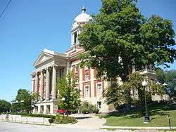 Mercer County Courthouse (1909) | |
| Etymology: Hugh Mercer | |
| Motto(s): "Meet Me In Mercer" | |
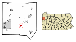 Location of Mercer in Mercer County, Pennsylvania. | |
 Mercer, Pennsylvania Location of Mercer within Pennsylvania | |
| Coordinates: 41°13′35″N 80°14′15″W | |
| Country | United States |
| State | Pennsylvania |
| County | Mercer |
| Established | 1803 |
| Area | |
| • Total | 1.14 sq mi (2.95 km2) |
| • Land | 1.14 sq mi (2.95 km2) |
| • Water | 0.00 sq mi (0.00 km2) |
| Elevation | 1,280 ft (390 m) |
| Highest elevation | 1,280 ft (390 m) |
| Lowest elevation | 1,075 ft (328 m) |
| Population (2010) | |
| • Total | 2,002 |
| • Estimate (2018)[3] | 1,866 |
| • Density | 1,660.23/sq mi (641.23/km2) |
| Time zone | UTC-4 (EST) |
| • Summer (DST) | UTC-5 (EDT) |
| Zip code | 16137 |
| Area code(s) | 724 |
The community was named after physician Brigadier General Hugh Mercer. Brigadier General Mercer was a close friend to General Washington and became a rallying point for the Battle of Princeton. The town is also known for its Memorial Day Parade with the main street lined with 500 flags. Each February it holds Penn's Woods West Arts & Crafts Festival at the Mercer Area High School as well as Victorian Days in the summer. Penns Woods West and Victorian Days are no longer being held in the Borough. The Mercer County Court House and Christiana Lindsey House are listed on the National Register of Historic Places.[5] At the time of his inauguration in Mercer in January 2002, Chris Portman was one of the youngest mayors in the history of the USA.
Geography
Mercer is located at 41°13′35″N 80°14′15″W (41.226347, -80.237436).[6] According to the United States Census Bureau, the borough has a total area of 1.2 square miles (3.1 km2), all land.
Point of interest
The United States post office in Mercer contains a mural, Clearing the Land, painted in 1940 by Lorin Thompson. Murals were produced from 1934 to 1943 in the United States through the Section of Painting and Sculpture, later called the Section of Fine Arts, of the Treasury Department.
Demographics
| Historical population | |||
|---|---|---|---|
| Census | Pop. | %± | |
| 1840 | 781 | — | |
| 1850 | 1,004 | 28.6% | |
| 1860 | 1,249 | 24.4% | |
| 1870 | 1,235 | −1.1% | |
| 1880 | 2,344 | 89.8% | |
| 1890 | 2,138 | −8.8% | |
| 1900 | 1,804 | −15.6% | |
| 1910 | 2,026 | 12.3% | |
| 1920 | 1,932 | −4.6% | |
| 1930 | 2,125 | 10.0% | |
| 1940 | 2,272 | 6.9% | |
| 1950 | 2,397 | 5.5% | |
| 1960 | 2,800 | 16.8% | |
| 1970 | 2,773 | −1.0% | |
| 1980 | 2,532 | −8.7% | |
| 1990 | 2,444 | −3.5% | |
| 2000 | 2,391 | −2.2% | |
| 2010 | 2,002 | −16.3% | |
| Est. 2018 | 1,866 | [3] | −6.8% |
| Sources:[7][8][9] | |||
At the 2000 census there were 2,391 people, 1,020 households, and 609 families residing in the borough. The population density was 1,930.3 people per square mile (744.5/km2). There were 1,086 housing units at an average density of 876.7 per square mile (338.2/km2). The racial makeup of the borough was 96.45% White, 2.17% African American, 0.17% Native American, 0.21% Asian, 0.04% Pacific Islander, 0.17% from other races, and 0.79% from two or more races. Hispanic or Latino of any race were 0.84%.[8]
There were 1,020 households, 26.8% had children under the age of 18 living with them, 43.7% were married couples living together, 13.1% had a female householder with no husband present, and 40.2% were non-families. 34.2% of households were made up of individuals, and 13.3% were one person aged 65 or older. The average household size was 2.24 and the average family size was 2.89.
In the borough the population was spread out, with 22.2% under the age of 18, 9.2% from 18 to 24, 29.2% from 25 to 44, 22.6% from 45 to 64, and 16.8% 65 or older. The median age was 37 years. For every 100 females there were 100.8 males. For every 100 females age 18 and over, there were 95.3 males.
The median household income was $29,795 and the median family income was $46,979. Males had a median income of $27,371 versus $19,576 for females. The per capita income for the borough was $22,161. About 6.0% of families and 9.0% of the population were below the poverty line, including 8.8% of those under age 18 and 8.5% of those age 65 or over.
Notable people
- John Bingham, drafter of the Fourteenth Amendment to the United States Constitution
- Leech Maskrey. major league baseball player who played for the Cincinnati Red Stockings in 1886
- Gary Peters, major league baseball player who played for the Chicago White Sox and Boston Red Sox. 1963 AL Rookie of the Year
- Trent Reznor, musician and creator of the band Nine Inch Nails
- Samuel Waugh, painter
- J. C. Williamson, actor and impresario
References
- "2017 U.S. Gazetteer Files". United States Census Bureau. Retrieved Mar 24, 2019.
- "Indian Run Topo Map, Mercer County PA (Mercer Area)". TopoZone. Locality, LLC. Retrieved 7 September 2019.
- "Population and Housing Unit Estimates". Retrieved December 26, 2019.
- "Find a County". National Association of Counties. Retrieved 2011-06-07.
- "National Register Information System". National Register of Historic Places. National Park Service. July 9, 2010.
- "US Gazetteer files: 2010, 2000, and 1990". United States Census Bureau. 2011-02-12. Retrieved 2011-04-23.
- "Census of Population and Housing". U.S. Census Bureau. Retrieved 11 December 2013.
- "U.S. Census website". United States Census Bureau. Retrieved 2008-01-31.
- "Incorporated Places and Minor Civil Divisions Datasets: Subcounty Resident Population Estimates: April 1, 2010 to July 1, 2012". Population Estimates. U.S. Census Bureau. Archived from the original on 11 June 2013. Retrieved 11 December 2013.
Municipalities and communities of Mercer County, Pennsylvania, United States | ||
|---|---|---|
| Cities | 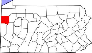 | |
| Boroughs | ||
| Townships |
| |
| CDPs | ||
| Unincorporated communities | ||
| Authority control |
|
|---|