McKean County, Pennsylvania
McKean County is a rural county in the U.S. state of Pennsylvania. As of the 2010 census, the population was 43,450.[1] Its county seat is Smethport.[2] The county was created in 1804 and organized in 1826.[3] It was named in honor of former Pennsylvania Governor and Declaration of Independence signer Thomas McKean.[4]
McKean County | |
|---|---|
 McKean County Courthouse | |
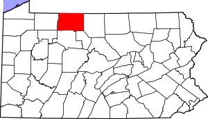 Location within the U.S. state of Pennsylvania | |
 Pennsylvania's location within the U.S. | |
| Coordinates: 41°48′40″N 78°26′41″W | |
| Country | |
| State | |
| Founded | September 1, 1826 |
| Named for | Thomas McKean |
| Seat | Smethport |
| Largest city | Bradford |
| Area | |
| • Total | 984 sq mi (2,550 km2) |
| • Land | 979 sq mi (2,540 km2) |
| • Water | 5.0 sq mi (13 km2) 0.5%% |
| Population | |
| • Estimate (2018) | 40,968 |
| • Density | 43/sq mi (17/km2) |
| Time zone | UTC−5 (Eastern) |
| • Summer (DST) | UTC−4 (EDT) |
| Congressional district | 15th |
| Website | www |
McKean County comprises the Bradford, PA Micropolitan Statistical Area. It is in a sparsely populated region known as the "Pennsylvania Wilds", including the Allegheny National Forest and borders New York. McKean County is home of "The Zippo Lighter" and boasts of being "The Black Cherry Capital of the World."
McKean County was founded because of its natural resources of oil and timber, both of which continue to provide a significant input to the economy. Today, a university, rural medical center, and manufacturing companies balance the area's economy.
Geography
According to the U.S. Census Bureau, the county has an area of 984 square miles (2,550 km2), of which 979 square miles (2,540 km2) is land and 5.0 square miles (13 km2) (0.5%) is water.[5] It has a warm-summer humid continental climate (Dfb) and average monthly temperatures in downtown Bradford range from 23.0 °F in January to 67.6 °F in July, while in Mount Jewett they range from 21.2 °F in January to 65.1 °F in July.
Adjacent counties
- Cattaraugus County, New York (north)
- Allegany County, New York (northeast)
- Potter County (east)
- Cameron County (southeast)
- Elk County (south)
- Forest County (southwest)
- Warren County (west)
Major highways
National protected area
- Allegheny National Forest (part)
- Allegheny National Recreation Area (part)
Demographics
| Historical population | |||
|---|---|---|---|
| Census | Pop. | %± | |
| 1810 | 142 | — | |
| 1820 | 728 | 412.7% | |
| 1830 | 1,439 | 97.7% | |
| 1840 | 2,975 | 106.7% | |
| 1850 | 5,254 | 76.6% | |
| 1860 | 8,859 | 68.6% | |
| 1870 | 8,825 | −0.4% | |
| 1880 | 42,565 | 382.3% | |
| 1890 | 46,863 | 10.1% | |
| 1900 | 51,343 | 9.6% | |
| 1910 | 47,868 | −6.8% | |
| 1920 | 48,934 | 2.2% | |
| 1930 | 55,167 | 12.7% | |
| 1940 | 56,673 | 2.7% | |
| 1950 | 56,607 | −0.1% | |
| 1960 | 54,517 | −3.7% | |
| 1970 | 51,915 | −4.8% | |
| 1980 | 50,653 | −2.4% | |
| 1990 | 47,131 | −7.0% | |
| 2000 | 45,963 | −2.5% | |
| 2010 | 43,450 | −5.5% | |
| Est. 2018 | 40,968 | [6] | −5.7% |
| U.S. Decennial Census[7] 1790-1960[8] 1900-1990[9] 1990-2000[10] 2010-2017[1] | |||
As of the 2000 census,[11] there were 45,936 people, 18,024 households, and 12,094 families residing in the county. The population density was 47 people per square mile (18/km²). There were 21,644 housing units at an average density of 22 per square mile (9/km²). The racial makeup of the county was 96.46% White, 1.87% Black, 0.32% Native American, 0.30% Asian, 0.02% Pacific Islander, 0.40% from other races, and 0.61% from two or more races. 1.06% of the population were Hispanic or Latino of any race. 35.0% German, 22.2% Irish, 14.6% Italian, 12.3% English, 10.0% Swedish, 8.6% American, 5.8% Polish, and 3.7% French ancestry.
There were 18,024 households out of which 30.50% had children under the age of 18 living with them, 52.50% were married couples living together, 10.10% had a female householder with no husband present, and 32.90% were non-families. 28.30% of all households were made up of individuals and 13.30% had someone living alone who was 65 years of age or older. The average household size was 2.40 and the average family size was 2.93.
In the county, the age distribution of the population shows 23.70% under the age of 18, 7.90% from 18 to 24, 28.50% from 25 to 44, 23.20% from 45 to 64, and 16.70% who were 65 years of age or older. The median age was 39 years. For every 100 females there were 100.40 males. For every 100 females age 18 and over, there were 98.70 males.
- Live birth rate
McKean County's live birth rate was 632 births in 1990. The County's live birth rate in 2000 was 473 births, while in 2011 it had declined to 447 babies.[12] Over the past 50 years (1960 to 2010), rural Pennsylvania saw a steady decline in both the number and proportion of residents under 18 years old. In 1960, 1.06 million rural residents, or 35 percent of the rural population, were children.
- County poverty demographics
According to research by The Center for Rural Pennsylvania, which is a legislative agency of the Pennsylvania General Assembly, the poverty rate for McKean County was 16.6% in 2014.[13] The statewide poverty rate was 13.6% in 2014. The 2012 childhood poverty rate by school district was: Bradford Area School District - 48.4% living at 185% or below than the Federal Poverty Level and Kane Area School District - 42.3, Otto-Eldred School District -49.8%, Port Allegany School District - 46.8, and Smethport Area School District - 44.8%.[14]
Micropolitan Statistical Area
The United States Office of Management and Budget[15] has designated McKean County as the Bradford, PA Micropolitan Statistical Area (µSA).[16] As of the 2010 U.S. Census[17] the micropolitan area ranked 13th most populous in Pennsylvania and the 277th most populous in the United States with a population of 43,450.
Law and government
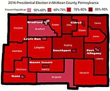
| Year | Republican | Democratic | Third parties |
|---|---|---|---|
| 2016 | 70.7% 11,635 | 24.5% 4,025 | 4.9% 804 |
| 2012 | 63.0% 9,545 | 35.0% 5,297 | 2.1% 312 |
| 2008 | 57.6% 9,224 | 40.4% 6,465 | 2.0% 321 |
| 2004 | 62.8% 10,941 | 36.1% 6,294 | 1.1% 191 |
| 2000 | 61.1% 9,661 | 34.9% 5,510 | 4.0% 635 |
| 1996 | 46.0% 6,838 | 37.1% 5,509 | 17.0% 2,522 |
| 1992 | 42.5% 6,965 | 32.5% 5,331 | 25.0% 4,104 |
| 1988 | 63.2% 9,323 | 35.9% 5,300 | 0.8% 124 |
| 1984 | 69.2% 10,963 | 30.4% 4,818 | 0.4% 58 |
| 1980 | 60.9% 9,229 | 33.4% 5,064 | 5.8% 873 |
| 1976 | 60.9% 10,305 | 38.0% 6,424 | 1.2% 197 |
| 1972 | 71.7% 11,958 | 27.1% 4,513 | 1.2% 202 |
| 1968 | 59.7% 10,506 | 35.9% 6,326 | 4.4% 775 |
| 1964 | 41.8% 7,948 | 57.6% 10,950 | 0.6% 109 |
| 1960 | 63.6% 13,699 | 36.1% 7,767 | 0.3% 66 |
| 1956 | 73.8% 14,725 | 25.8% 5,152 | 0.4% 73 |
| 1952 | 73.4% 15,256 | 25.9% 5,373 | 0.7% 147 |
| 1948 | 66.9% 10,218 | 31.3% 4,785 | 1.8% 269 |
| 1944 | 64.5% 11,988 | 34.9% 6,492 | 0.7% 121 |
| 1940 | 67.6% 14,822 | 31.9% 6,991 | 0.5% 119 |
| 1936 | 53.4% 11,837 | 43.9% 9,733 | 2.8% 611 |
| 1932 | 65.0% 9,970 | 30.4% 4,661 | 4.6% 704 |
| 1928 | 73.5% 14,012 | 26.0% 4,964 | 0.5% 90 |
| 1924 | 69.0% 9,072 | 18.1% 2,376 | 12.9% 1,701 |
| 1920 | 68.7% 7,830 | 22.0% 2,505 | 9.4% 1,071 |
| 1916 | 51.8% 4,300 | 38.1% 3,161 | 10.1% 838 |
| 1912 | 16.8% 1,345 | 29.5% 2,362 | 53.7% 4,294 |
| 1908 | 58.0% 5,073 | 32.8% 2,867 | 9.2% 805 |
| 1904 | 67.5% 5,719 | 19.3% 1,636 | 13.2% 1,120 |
| 1900 | 61.4% 6,319 | 33.3% 3,427 | 5.3% 547 |
| 1896 | 59.6% 5,077 | 36.1% 3,074 | 4.3% 369 |
| 1892 | 50.0% 3,594 | 39.6% 2,843 | 10.4% 750 |
| 1888 | 52.7% 4,066 | 37.9% 2,922 | 9.4% 721 |
State Senate[19]
- Joseph B. Scarnati III, Republican, Pennsylvania's 25th Senatorial District
State House of Representatives[19]
United States House of Representatives
United States Senate
- Pat Toomey, Republican
- Bob Casey, Jr., Democrat
Education

Public school districts
- Bradford Area School District
- Kane Area School District (Also covers part of Elk County)
- Otto-Eldred School District
- Port Allegany School District (Also covers part of Potter County)
- Smethport Area School District
- Oswayo Valley School District (Also covers part of Potter County)
The 500 school districts of Pennsylvania were ranked for student academic achievement by the Pittsburgh Business Times in 2008.
- Bradford Area School District - 403rd
- Kane Area School District - 342nd
- Otto-Eldred School District - 408th
- Port Allegany School District - 446th
- Smethport Area School District - 415th
- Oswayo Valley School District - 458th
Private schools
As reported by EdNA, Pennsylvania Department of Education, June 2010.
- Bradford Area Christian Academy, Bradford
- Chestnut Street Christian School, Bradford
- Custer City Private School
- St. Bernard School, Bradford
- Learning Center Inc, Bradford
- United Christian Academy, Smethport
Libraries
- Bradford Area Public Library
- Friends Memorial Public Library - Kane
- Hamlin Memorial Library - Smethport
- Mount Jewett Memorial Library
- Samuel W Smith Memorial Public Library - Port Allegany
Other education entities
- Beacon Light Behavioral Health Systems - Custer City
- Seneca Highlands Career and Technical Center - Port Allegany
- Seneca Highlands IU 9 - Smethport
- University of Pittsburgh at Bradford
- McKean County Historical Society's Museum at the Old Jail - Smethport
Recreation
There is one Pennsylvania state park in McKean County. Kinzua Bridge State Park is between U.S. Route 6 and Pennsylvania Route 59, just east of the Allegheny National Forest near Mount Jewett. When it was built, it was the highest and longest railroad bridge in the world. It was chosen by the Pennsylvania Department of Conservation and Natural Resources (DCNR) and its Bureau of Parks as one of "Twenty Must-See Pennsylvania State Parks" and is a Historic Civil Engineering Landmark. A tornado destroyed much of the bridge in 2003.
Communities
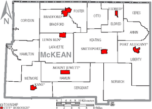
Under Pennsylvania law, there are four types of incorporated municipalities: cities, boroughs, townships, and, in at most two cases, towns. The following cities, boroughs and townships are located in McKean County:
City
Boroughs
- Eldred
- Kane
- Lewis Run
- Mount Jewett
- Port Allegany
- Smethport (county seat)
Townships
Census-designated places
Unincorporated communities
Population ranking
The population ranking of the following table is based on the 2010 census of McKean County.[17]
† county seat
| Rank | City/Town/etc. | Municipal type | Population (2010 Census) |
|---|---|---|---|
| 1 | Bradford | City | 8,770 |
| 2 | Kane | Borough | 3,730 |
| 3 | Port Allegany | Borough | 2,157 |
| 4 | † Smethport | Borough | 1,655 |
| 5 | Foster Brook | CDP | 1,251 |
| 6 | Mount Jewett | Borough | 919 |
| 7 | Eldred | Borough | 875 |
| 8 | Lewis Run | Borough | 617 |
| 9 | Rew | CDP | 199 |
References
- "State & County QuickFacts". United States Census Bureau. Archived from the original on June 6, 2011. Retrieved November 20, 2013.
- "Find a County". National Association of Counties. Archived from the original on May 31, 2011. Retrieved June 7, 2011.
- "Pennsylvania: Individual County Chronologies". Pennsylvania Atlas of Historical County Boundaries. The Newberry Library. 2008. Retrieved March 13, 2015.
- Gannett, Henry (1905). The Origin of Certain Place Names in the United States. U.S. Government Printing Office. p. 194.
- "2010 Census Gazetteer Files". United States Census Bureau. August 22, 2012. Retrieved March 9, 2015.
- "Population and Housing Unit Estimates". Retrieved October 10, 2018.
- "U.S. Decennial Census". United States Census Bureau. Retrieved March 9, 2015.
- "Historical Census Browser". University of Virginia Library. Retrieved March 9, 2015.
- Forstall, Richard L., ed. (March 24, 1995). "Population of Counties by Decennial Census: 1900 to 1990". United States Census Bureau. Retrieved March 9, 2015.
- "Census 2000 PHC-T-4. Ranking Tables for Counties: 1990 and 2000" (PDF). United States Census Bureau. April 2, 2001. Retrieved March 9, 2015.
- "U.S. Census website". United States Census Bureau. Retrieved 2008-01-31.
- Pennsylvania Department of Health, Birth Age County Reports 1990 and 2011, 2011
- US Census Bureau (2015). "Poverty Rates by County Small Area Income and Poverty Estimates".
- Pennsylvania Budget and Policy Center (2012). "Student Poverty Concentration 2012". Archived from the original on 2015-12-22. Retrieved 2016-02-18.
- "Office of Management and Budget - The White House". Retrieved 27 November 2018.
- "Archived copy". Archived from the original on 2015-09-24. Retrieved 2017-12-07.CS1 maint: archived copy as title (link)
- "2010 U.S. Census website". United States Census Bureau. Retrieved February 10, 2013.
- Leip, David. "Dave Leip's Atlas of U.S. Presidential Elections". uselectionatlas.org. Retrieved 27 November 2018.
- Center, Legislativate Data Processing. "Find Your Legislator". The official website for the Pennsylvania General Assembly. Retrieved 2017-05-11.
External links
| Wikimedia Commons has media related to McKean County, Pennsylvania. |
- A resource website for families in McKean County including the McKean County Resource Directory
- McKean County Government
- McKean County Capitol History
- Bradford Today
- Bradford Era News
- Gardeau Train Wreck of 2006 - A website about the train wreck and chemical spill of June 30, 2006. Location: Gardeau, Norwich Township, McKean County, Pennsylvania
Municipalities and communities of McKean County, Pennsylvania, United States | ||
|---|---|---|
| City | | |
| Boroughs | ||
| Townships | ||
| CDPs | ||
| Unincorporated communities | ||

| Authority control |
|
|---|