Schuylkill County, Pennsylvania
Schuylkill County (/ˈskuːlkɪl/,[1] locally /-kəl/) is a county in the Commonwealth of Pennsylvania. As of the 2010 census, the population was 148,289.[2] The county seat is Pottsville.[3] The county was created on March 1, 1811, from parts of Berks and Northampton counties[4] and named for the Schuylkill River, which originates in the county. On March 3, 1818 additional territory in its northeast was added from Columbia and Luzerne Counties.[5]
Schuylkill County | |
|---|---|
.jpg) Schuylkill County Courthouse | |
 Seal | |
 Location within the U.S. state of Pennsylvania | |
 Pennsylvania's location within the U.S. | |
| Coordinates: 40°42′N 76°13′W | |
| Country | |
| State | |
| Founded | March 1, 1811 |
| Named for | Schuylkill River |
| Seat | Pottsville |
| Largest city | Pottsville |
| Area | |
| • Total | 783 sq mi (2,030 km2) |
| • Land | 779 sq mi (2,020 km2) |
| • Water | 4.2 sq mi (11 km2) 0.5%% |
| Population | |
| • Estimate (2019) | 141,359 |
| • Density | 182/sq mi (70/km2) |
| Time zone | UTC−5 (Eastern) |
| • Summer (DST) | UTC−4 (EDT) |
| Area code | 570 717 |
| Congressional district | 9th |
| Website | www |
Schuylkill County comprises the Pottsville, PA Micropolitan Statistical Area. It is located in the heart of the anthracite Coal Region of Eastern Pennsylvania.
History
18th century
The lands constituting Schuylkill County were acquired by Penn's proprietors by treaty executed August 22, 1749, with representatives of the Six Nations and the Delaware, Shamokin and Shawnee, who received 500 pounds "lawful money of Pennsylvania". The territory described included all of Schuylkill County, except the northern part of Union Township which was included in the purchase of 1768.[6]
In the year 1754, the area that would become Schuylkill County was settled by Germans, as were areas that are now part of Berks, Dauphin, Lebanon, and Lehigh counties. The earliest settlers in southeastern Schuylkill County, which was then part of Northampton County, were primarily Moravian missionaries from Saxony. Other early settlers in southern Schuylkill County were German Palatines.
An early mill in the county was built in 1744 by John Finscher, but it later burned down. The first log church in the county was built in 1755. Native American massacres were commonplace in Schuylkill County between 1755 and 1765. Warrant for tracts of land in the vicinity of McKeansburg were in existence as early as 1750.[7] Found by Sammy Hepler in 1789.
19th century
Schuylkill County was created via an Act of Assembly on March 1, 1811, from portions of Berks and Northampton counties.[8] More land was added to the county in 1818, from Columbia and Luzerne counties.[9] At the time of its creation, the County had a population of about 6,000.[10] An early book of Schuylkill County history was written by Daniel Deibert in 1802.[7]
Orwigsburg was the first community in Schuylkill County to be laid out. During the early years of Schuylkill County, there was an attempt to make McKeansburg the county seat, while Orwigsburg was also a contender. Orwigsburg was agreed upon to be the county seat, as it was deemed to be well-suited for industries.[7] Beginning in 1831, sentiment began to rise for moving the county seat to Pottsville. In 1846, the Legislature passed the Act which was approved by Governor Francis R. Shunk on March 13, submitting the question to the voters. The change was desired principally because the railroad and canal connections with Orwigsburg were problematic to transport the public to that town without losing valuable time, while Pottsville had such facilities and was within easy access from all parts of the county.[10]
20th century
Kelayres Massacre On November 5, 1934 (election eve), a parade marched through the Village of Kelayres, Kline Township.[11] A crowd of Democratic Party supporters walked toward the home of Republican Party leader, Joseph Bruno. Frustration with Bruno family control of the school board and other local offices had been growing for years. Shots were fired from the Bruno home and yard located at Fourth & Centre Streets. Several people were killed and more than 20 marchers were injured.[12]
Mining history
Anthracite coal (then called stone coal) was discovered near where Pottsville was to rise in 1790 by Necho Allen.[lower-alpha 1] In the year 1795 a blacksmith in Schuylkill County named Whetstone also learned how to use it successfully for smithing purposes. In the year 1806 coal was found in cutting the tail-race of the Valley (Iron) Forge, on the Schuylkill, and was used successfully by Daniel Berlin, a blacksmith, which led to its general use by the smiths in the neighborhood.[13]
However, it wasn't until coal found an industrial use, that mining became important. In 1812, George Shoemaker who with Necho Allen had also discovered “stone coal” at Centerville in Schuylkill County personally delivered some coal to Philadelphia. Most of the coal was given away to persons who would attempt to find a use for it. Most of the experiments failed and though Shoemaker was nearly run out of town and called an “Imposter”, Mellon and Bishop of Delaware County successfully used it in their rolling mill. Then other rolling mills in the area also successfully used the fuel and thus a large industrial market was born[14]
Then the Schuylkill Navigation Company was chartered in 1815 to build a series of navigation improvements in the Schuylkill River, nearly as early as the much more ambitious Erie Canal and well ahead of other key canals fueling the Industrial Revolution, such as the Delaware and Hudson, the Lehigh, the Chesapeake and Ohio, Delaware and Raritan and Morris canals. The originators of the project did not count upon the coal trade to promote the success of the undertaking. They looked forward mainly to the agricultural products below the mountains, the lumber of Schuylkill county, and the grain and other products of the counties between the Susquehanna and Schuylkill Rivers. The first shipments of coal by canal were made in the year 1822, when 1,480 tons were sent down the line.[15]
This outlet for a regular supply of anthracite coal existing, public attention was strongly attracted to the southern anthracite coal field. There was a rush to Schuylkill County of capitalists, adventurers and fortune hunters, who were inspired with the idea of suddenly becoming millionaires. This was the first speculative era of the Schuylkill coal trade. Pottsville became the center of the movement. The more successful explorers revealed the existence of a great number of veins of coal, extending over a vast stretch of county and with a seemingly inexhaustible quantity of coal. These discoveries brought excitement and speculation; lands were bought (and sold); roads were laid out in the forest, mines were opened and railroads projected, and innumerable town plots planned. The demand for houses was so great that the lumber for quite a large number was actually framed in Philadelphia and sent by canal to the burgeoning coal region.[9]
Coal mining firms were small, family owned concerns. There was an earnest and increasing opposition to incorporated coal companies in the Schuylkill region. In these years, coal mining operations in the Schuylkill region were conducted with simplicity and economy, very little capital being required for their successful prosecution. The workings were all above the water level, no machinery being required for water drainage or for hoisting the coal to the surface. Coal breakers and other expensive fixtures and appliances for the preparation of coal had not then been introduced. There were many operators sending from five to six thousand tons to market annually (which was then considered a respectable business) that had not at any time a capital employed of as many thousands of dollars, including the first land purchase of the coal mine. It was asserted that it did not require as much capital to buy a piece of coal land and open the coal mines upon it as it did to buy a decent farm and stock it or did not require as much capital to work a coal mine as it did to establish a line of stages or transportation wagons.[9]
Eventually, railroads replaced the canals as the primary means of transporting coal to the markets. See below “Railroad History”. Mining did become big corporate business, especially after the Civil War. As a result, the Middle Coal Field was developed in the 1860s and the Philadelphia and Reading Railroad created a subsidiary (Philadelphia and Reading Coal and Iron Company) to buy or lease and develop the expanding industrial coal trade. For example, consumption of coal along the Schuylkill above Philadelphia in the year 1839, at which time the first anthracite furnace in the United States - the Pioneer, at Pottsville - was operational, was 30,290 tons. Ten years afterward it had increased to 239,290 tons, in the year 1859 to 554,774 tons, and in 1873 to 1,787,205 tons.[9]
The mining industry was the catalyst for mass immigration to Schuylkill County in the 19th and 20th centuries. As mines became more numerous – by 1846 there were 110 operators in the region and 142 collieries in Schuylkill County - and more complex - pumping (in 1846 there were 35 collieries below water level), mechanical breakers, steam locomotives it became more labor-intensive; not just for accomplishing mining tasks but also to support the peripheral industries related to mining. Such industries included manufacturing of explosives, metal screens, pump components, piping, timber for support, etc. This led to an influx of population into Schuylkill and other anthracite counties to fill these jobs. Beginning with the Irish immigration in the 1840s (fueled by the potato famine), after the Civil War, beginning in the 1870s, newcomers arrived from Eastern Europe. Poles, Hungarians, Lithuanians, Slovaks, Rusyns and Ukrainians (Ruthenians) settled in the villages of Schuylkill County and took their place among the laborers in the coal mines. By the 1880s and 1890s thousands of Italians immigrated for jobs related to mining.
The anthracite mining industry peaked its production in 1917. Subsequently, the industry declined (with exceptions during the First and Second World Wars). In the 1950s and 1960s underground mining operations closed in Schuylkill County and throughout the Coal Region and surface mining became predominate. The following shows the decline in production and the number of employees from 1950 until 1965, and the production and number of employees in 2015, the last year for which data is available. This includes all anthracite production in Pennsylvania and not just Schuylkill County:[16]
| Year | Production Net (Tons) | Number of Employees |
|---|---|---|
| 1950 | 44,076,703 | 72,624 |
| 1955 | 26,204,554 | 33,523 |
| 1960 | 18,817,441 | 19,051 |
| 1965 | 14,865,955 | 11,132 |
| 2016 | 1,500,000 | 952 |
In 2016, Schuylkill County had 6 underground mines and 25 surface mines operating, producing 62,000 tons and 833,000 tons of coal respectively.[17] Anthracite production today is unique in that operators are re-mining areas that were previously mined. It is estimated that 98 percent of the anthracite produced is from existing mines.[18]
Railroad history
In the early 19th century southern Schuylkill County was served by the Union Canal out of Pine Grove Township with connections west, and the Schuylkill Canal (more properly the Schuylkill Navigation) southward from Port Carbon to Philadelphia.[19] Coal mined by Lehigh Coal and Navigation in the Tamaqua and Coaldale areas was often shipped down the Lehigh Canal from Jim Thorpe in neighboring Carbon County. To the north, mountain and ridges were a natural barrier to navigation. Other means would be required to transport coal out of the rich basin of the Mahanoy Valley. Numerous railroads were begun in the late 1820s and early 1830s, north of the Schuylkill Canal to enable the transport of coal to the canal terminus and thence to Philadelphila and other markets. These included:[20]
- The Schuylkill Valley Railroad, commencing at Port Carbon to Tuscarora, a distance of ten miles, with fifteen branches intersecting it, the distances combined amounting to another ten miles.
- The Mill Creek Railroad, from Port Carbon up the valley of Mill creek four miles, with about three miles of branch roads intersecting it. This was the first road completed and was in operation part of the year 1829.
- The Mine Hill and Schuylkill Haven Railroad, commencing at Schuylkill Haven to Minersville, having a length, including the west branch, of fifteen miles. There were also about five miles of branches intersecting it.
- The Mount Carbon Railroad, commencing at Mount Carbon and extending up the east and west branches of the Norwegian creek; a length of road seven miles.
- The Little Schuylkill Railroad, from Port Clinton to Tamaqua, twenty miles in length.
Of prime importance was the Mine Hill and Schuylkill Haven, which served the Schuylkill Canal. Chartered in 1831, tracks were laid from the "flats" in Schuylkill Haven along the river through Cressona and Minersville to Tremont. The railroad eventually reached Ashland and Locust Gap via the Gordon Planes.
Construction beginning in 1829, the Little Schuylkill Railroad ran from Port Clinton northward to Mahanoy Junction above Tamaqua. It would become the keystone of the Philadelphia and Reading system, serving as a gauntlet for its eastern and western branches. Connecting with it were four important lines. The 146 mile (235 km) Catawissa Railroad operated from Mahanoy Junction to West Milton, providing access to the Mahanoy region by joining the northern terminus of the Little Schuylkill with connections to New York City, Scranton and also points west.[21] At Port Clinton, it connected with the P&R's main line from Mount Carbon. Its most important connection would be with the Mahanoy and Broad Mountain Railway via Mahanoy Tunnel and East Mahanoy Railroad.
There was once over 1,000 miles (1600 km) of railroad track in Schuylkill County. At point in the 1800s, the largest railyard and roundhouse in the world was located at Mill Creek, PA., between Pottsville and St. Clair.
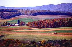
Farming history
Schuylkill County's history is not solely a story about coal mining and railroads. The first settlers were farmers or lumbermen. In the fertile agricultural valleys (not underlain with coal) between the Blue Mountain range in the south to near the Susquehanna River to the north, generations of farming families have helped feed their neighbors in the mines, on the rails, on the canals, and in the towns within and surrounding the county. After settlement of the farms, came a period of diversified, small scale production that lasted until about the late 19th century. After then, more highly mechanized small farms combined livestock and crop production for new, mainly local and regional markets. Then the system re-oriented to add orchard products, trees and plant products and poultry farming. In 2012, the estimated value of agricultural products in Schuylkill County sold was $165,853,000, ranking 9th in the State and 704th in the US (counties).[22] The county ranks in the top 100 in the US counties for nursery, greenhouse, floriculture, and sod products and cut Christmas trees and short rotation woody crops.[9]
Textile industry history
Textile manufacturing evolved as a major industry in the county near the beginning of the 20th Century. Phillips & Jones Co. (Now known as Phillips Van Heusen - PVH Corp, began in Pottsville, Pennsylvania, and was once Schuylkill County's largest employer.[23] Another textile giant, John E. Morgan Knitting Mills also began manufacturing in 1945 in Tamaqua, eventually becoming the largest employer in the county in the 1970-80s.[24] In addition there were numerous smaller shops all over the county, doing subcontract work for the major manufacturers all over the US. As the century wore on, textile industry, which employed significant numbers of women, rivaled the coal mining industry in importance, especially after the end of World War 2, when that industry began to collapse. As a consequence of the Great Depression, garment manufacturers began to look for people willing to work (at lower wages) outside of New York City, the center of the industry. Pennsylvania became the 3rd highest-ranked apparel manufacturer in the United States by 1940. Women's clothing became the state's fastest growing product.[25] The dominance of the industry in Schuylkill County lasted until the last decade of the 20th century,[26] when it was clear that the garment manufacturing industry was leaving Schuylkill County and other regions of the US and moving to foreign countries. By 2011, only six manufacturers employing 341 people remained in the county.[27]
Geography
According to the U.S. Census Bureau, the county has a total area of 783 square miles (2,030 km2), of which 779 square miles (2,020 km2) is land and 4.2 square miles (11 km2) (0.5%) is water.[28]
The Schuylkill River headwaters are found in the county, starting in the Appalachian Mountains, and flows through many towns and the city of Reading, Pennsylvania to Philadelphia where it flows into the Delaware River. The Schuylkill drains the majority of the county while some western and northern areas of the county are drained by the Susquehanna River. The Swatara Creek, Wiconisco Creek, Mahantango Creek, Mahanoy Creek, and Catawissa Creek all start in Schuylkill County and are tributaries of the Susquehanna. Areas of the eastern portion of the county drain into the Lehigh River via the Quakake Creek, Nesquehoning Creek, Mahoning Creek, and Lizard Creek, all of which also start in the county. To the south, southern Schuylkill county is home to Blue Mountain and the Appalachian Trail. Broad Mountain crosses the county from northeast to southwest.
Schuylkill County is located in northeastern Pennsylvania's Coal Region. It is located just north of the Lehigh Valley and Reading metropolitan areas. Portions of eastern Schuylkill County around Tamaqua are located in the Pocono Mountains. As a result, like other portions of the Poconos, eastern Schuylkill has experienced an influx of people from New York City and New Jersey who commute into Manhattan each day. The commute can take up to two hours each way due to distance and traffic. Far western areas of the county are located near Harrisburg and are sometimes considered to be located in South Central Pennsylvania.
Climate
The county has a humid continental climate (Dfa/Dfb) with four distinct seasons. The hardiness zone is 6b in lowlands of the south-central and SW areas of the county. In the remainder of Schuylkill, the zone is 6a except in some higher areas to the NE on Broad Mountain where it is 5b. Broad Mountain separates the Susquehanna and Schuylkill watersheds for much of its length. Average monthly temperatures in the vicinity of downtown Pottsville range from 27.3 °F in January to 72.3 °F in July, while in Mahanoy City they range from 24.3 °F in January to 69.3 °F in July.
Adjacent counties
- Luzerne County (north)
- Carbon County (northeast)
- Lehigh County (southeast)
- Berks County (south)
- Lebanon County (southwest)
- Dauphin County (southwest)
- Northumberland County (northwest)
- Columbia County (northwest)
Demographics
| Historical population | |||
|---|---|---|---|
| Census | Pop. | %± | |
| 1820 | 11,339 | — | |
| 1830 | 20,744 | 82.9% | |
| 1840 | 29,053 | 40.1% | |
| 1850 | 60,713 | 109.0% | |
| 1860 | 89,510 | 47.4% | |
| 1870 | 116,428 | 30.1% | |
| 1880 | 129,974 | 11.6% | |
| 1890 | 154,163 | 18.6% | |
| 1900 | 172,927 | 12.2% | |
| 1910 | 207,894 | 20.2% | |
| 1920 | 217,754 | 4.7% | |
| 1930 | 235,505 | 8.2% | |
| 1940 | 228,331 | −3.0% | |
| 1950 | 200,577 | −12.2% | |
| 1960 | 173,027 | −13.7% | |
| 1970 | 160,089 | −7.5% | |
| 1980 | 160,630 | 0.3% | |
| 1990 | 152,585 | −5.0% | |
| 2000 | 150,336 | −1.5% | |
| 2010 | 148,289 | −1.4% | |
| Est. 2019 | 141,359 | [29] | −4.7% |
| U.S. Decennial Census[30] 1790–1960[31] 1900–1990[32] 1990–2000[33] 2010–2019[2] | |||
As of the census[34] of 2000, there were 150,336 people, 60,530 households, and 40,131 families residing in the county. The population density was 193 people per square mile (75/km²). There were 67,806 housing units at an average density of 87 per square mile (34/km²). The racial makeup of the county was 96.62% White, 0.08% Native American, 0.42% Asian, 0.01% Pacific Islander, 0.35% from other races, 2.09% African American, and 0.43% from two or more races. Hispanic or Latino of any race were 1.11% of the population. 29.0% were of Slovak, 14.1% Irish, 9.7% German, 7.5% Italian, 5.6% American and 5.1% Greek ancestry. 95.7% spoke English and 1.2% Spanish as their first language.
There were 60,530 households out of which 26.80% had children under the age of 18 living with them, 51.40% were married couples living together, 10.20% had a female householder with no husband present, and 33.70% were non-families. 29.90% of all households were made up of individuals and 16.50% had someone living alone who was 65 years of age or older. The average household size was 2.36 and the average family size was 2.93.
In the county, the population was spread out with 20.90% under the age of 18, 7.20% from 18 to 24, 28.30% from 25 to 44, 23.80% from 45 to 64, and 19.90% who were 65 years of age or older. The median age was 41 years. For every 100 females there were 99.10 males. For every 100 females age 18 and over, there were 97.20 males.
Schuylkill County is one of the most heavily Lithuanian parts of the United States. New Philadelphia, West Mahanoy, Shenandoah, and Girardville have the highest proportions of Lithuanian Americans of all places in the country. Lithuanian Roman Catholic parishes could be found in Shenandoah (St. George); Mahanoy City (St Joseph); Minersville (St. Francis of Assisi); Tamaqua (SS. Peter and Paul); Frackville (Annunciation BVM); Girardville (St. Vincent de Paul); Gilberton (Our Lady of Siluva, formerly St. Louis); and Coaldale (St. John the Baptist). Also in Schuylkill County (as well as its neighbor to the north, Luzerne County) are Tyroleans, whose ancestors immigrated from the County of Tyrol. Although they bore Italian surnames, the ancestors of the Tyroleans, who immigrated to the Coal Region in the late 19th century and early 20th century, spoke German as their native language. The Tirolesi Alpini organization in Hazleton continues to preserve and promote Tyrolean culture. Irish Americans and Polish Americans are also predominant. The southern and western portions of Schuylkill County which border Berks, Dauphin, Lehigh, and Lebanon counties are predominantly Pennsylvania Dutch.
- Birth rate
Schuylkill County's live birth rate was 1,794 births in 1990. The County's live birth rate in 2000 declined to 1,439 births, while in 2011 it was 1,446 babies.[35][36][37] From 1960 to 2010, rural Pennsylvania has experienced an ongoing decline in the number of residents under 18 years old.[38]
- Teen pregnancy rate
Schuylkill County had 33 babies born to teens (age 15-19) in 2011. In 2015, the number of teen births in Schuylkill County was 32.[39]
- County poverty demographics
According to research by The Center for Rural Pennsylvania, which is a legislative agency of the Pennsylvania General Assembly, the poverty rate for Schuylkill County was 13.5% in 2014.[40] The statewide poverty rate was 13.6% in 2014. The 2012 childhood poverty rate by school district was: Blue Mountain School District - 24.1% living at 185% or below than the Federal Poverty Level; Mahanoy Area School District - 64.6%; Minersville Area School District - 47.1%; North Schuylkill School District - 44.3%; Pine Grove Area School District - 38%; Pottsville Area School District - 53.5%; Saint Clair Area School District - 53.4%; Schuylkill Haven Area School District - 37.7%; Shenandoah Valley School District - 75.5%; Tamaqua Area School District - 40.9%; Tri-Valley School District - 36.8% and Williams Valley School District - 43.4%.[41] The child poverty rate is collected by the school districts as part of the federal free school lunch program.
Micropolitan Statistical Area
The United States Office of Management and Budget[42] has designated Schuylkill County as the Pottsville, PA Micropolitan Statistical Area (µSA).[43] As of the 2010 U.S. Census[44] the micropolitan area ranked the number 1 most populous in the State of Pennsylvania and the 5th most populous in the United States with a population of 148,289.
Law and government
| Schuylkill County Sheriff's Department | |
|---|---|
 | |
| Abbreviation | SCSD |
| Jurisdictional structure | |
| Operations jurisdiction | Schuylkill, Pennsylvania, USA |
| |
| Map of Schuylkill County Sheriff's Department's jurisdiction. | |
| Size | 778 square miles (2,000 km2) |
| Population | 150,336(est.) |
| General nature |
|
| Headquarters | Pottsville, Pennsylvania |
| Police Officers | 12 |
| Elected officer responsible |
|
| Agency executive |
|
| Website | |
| Schuylkill Sheriff Webpage | |
The Schuylkill County Sheriff's Department in Schuylkill County, Pennsylvania consists of the Sheriff's Office, Security Guard Service, and Central Booking. The Sheriff's Office is composed of a Civil and Criminal Division. The Civil Division processes real estate and property paperwork, as well as issue firearms permits. The Criminal Division is responsible for the security of the courthouses, as well as the transport of prisoners. The Security Guard Service is responsible for detecting and interdicting weapons before they can enter a courthouse. Central Booking processes fingerprints and photographs of arrested individuals.
Politics
As of November 2008, there were 94,110 registered voters in Schuylkill County.[45]
- Republican: 45,054 (47.87%)
- Democratic: 40,092 (42.60%)
- Other Parties: 8,964 (9.53%)
As of February 2020, there were 84,551 registered voters in Schuylkill County.[46]
- Republican: 44,098 (52.2%)
- Democratic: 29,884 (35.3%)
- Other Parties: 10,569 (12.5%)
While the Republican Party has been historically dominant in Schuylkill County politics, Democrats became dominant at the county level after the 2007 elections. John McCain received 53.6% of the vote to 44.9% for Barack Obama in November 2008. In the state row offices of the same election, each statewide winner carried the county. In 2006 Democrat Tim Seip won the heavily Republican 125th House district and Bob Casey Jr. carried Schuylkill when he unseated incumbent Republican US Senator Rick Santorum. Former State Representative Dave Argall won the special election of March 3 to succeed the late State Senator Jim Rhoades and was sworn in on March 17. Jerry Knowles won the special election for Argall's seat in the 124th House district on May 19. In 2010, the GOP regained ground when Seip was defeated for reelection by Republican Mike Tobash. In 2011, the GOP reclaimed the county government. This GOP resurgence has been followed by the subsequent election of Donald Trump in 2016, where he received 70% of the area's popular vote to Hillary Clinton's 26.7%.[47]
Commissioners
- Barron "Boots" Hetherington, Republican
- George Halcovage, chair, Republican
- Gary J. Hess, Democrat
Other county officials
- Clerk of Courts, Maria Casey, Republican
- Controller, Christy Joy, Republican
- Coroner, David J. Moylan, Republican
- District Attorney, Michael O'Pake, Democrat
- Prothonotary, David J. Dutcavich, Republican
- Recorder of Deeds, Ann Dudish, Republican (appointed)
- Register of Wills, Theresa Santai-Gaffney, Republican
- Sheriff, Joseph Groody, Democrat
- Treasurer, Linda Marchalk, Republican
Pennsylvania House of Representatives[48]
- Neal Goodman, Democrat, 123rd district
- Jerry Knowles, Republican, 124th district
- Mike Tobash, Republican, 125th district
Pennsylvania Senate[48]
- Dave Argall, Republican, 29th district
United States House of Representatives
- Dan Meuser, Republican, 9th district
United States Senate
- Pat Toomey, Republican
- Bob Casey, Jr., Democrat
| Year | Republican | Democratic | Third parties |
|---|---|---|---|
| 2016 | 69.4% 44,001 | 26.5% 16,770 | 4.1% 2,614 |
| 2012 | 55.6% 32,278 | 42.3% 24,546 | 2.1% 1,224 |
| 2008 | 53.1% 33,767 | 44.5% 28,300 | 2.4% 1,538 |
| 2004 | 54.6% 35,640 | 44.8% 29,231 | 0.6% 398 |
| 2000 | 51.2% 29,841 | 45.0% 26,215 | 3.9% 2,244 |
| 1996 | 40.5% 22,920 | 43.9% 24,860 | 15.6% 8,849 |
| 1992 | 40.9% 25,780 | 37.6% 23,679 | 21.5% 13,570 |
| 1988 | 56.5% 32,666 | 42.9% 24,797 | 0.7% 379 |
| 1984 | 59.0% 37,330 | 40.7% 25,758 | 0.4% 224 |
| 1980 | 55.8% 36,273 | 38.4% 24,968 | 5.7% 3,728 |
| 1976 | 47.7% 31,944 | 50.6% 33,905 | 1.6% 1,099 |
| 1972 | 61.6% 44,071 | 36.4% 26,077 | 2.0% 1,447 |
| 1968 | 48.5% 37,194 | 45.6% 34,982 | 5.8% 4,469 |
| 1964 | 34.3% 26,386 | 65.6% 50,560 | 0.1% 96 |
| 1960 | 49.8% 44,187 | 50.1% 44,430 | 0.1% 70 |
| 1956 | 62.0% 51,670 | 37.9% 31,645 | 0.1% 91 |
| 1952 | 59.4% 51,437 | 40.4% 34,987 | 0.2% 186 |
| 1948 | 60.1% 44,176 | 38.4% 28,194 | 1.5% 1,122 |
| 1944 | 53.0% 40,671 | 46.7% 35,852 | 0.3% 221 |
| 1940 | 47.1% 43,505 | 52.7% 48,739 | 0.3% 231 |
| 1936 | 44.0% 44,353 | 54.7% 55,183 | 1.4% 1,385 |
| 1932 | 46.9% 32,492 | 50.5% 35,023 | 2.6% 1,790 |
| 1928 | 53.1% 46,033 | 46.6% 40,424 | 0.4% 311 |
| 1924 | 64.4% 34,578 | 18.8% 10,111 | 16.7% 8,967 |
| 1920 | 59.5% 30,259 | 36.8% 18,746 | 3.7% 1,882 |
| 1916 | 55.0% 17,806 | 41.4% 13,396 | 3.6% 1,155 |
| 1912 | 11.1% 3,557 | 36.8% 11,812 | 52.1% 16,706 |
| 1908 | 52.6% 18,758 | 43.4% 15,481 | 4.0% 1,440 |
| 1904 | 65.1% 21,046 | 31.3% 10,115 | 3.6% 1,167 |
| 1900 | 50.7% 15,327 | 48.0% 14,496 | 1.3% 392 |
| 1896 | 52.6% 17,045 | 45.5% 14,745 | 1.9% 617 |
| 1892 | 44.9% 11,426 | 53.8% 13,677 | 1.3% 321 |
| 1888 | 48.2% 12,522 | 50.3% 13,054 | 1.6% 404 |
Education
Colleges and universities
- Penn State Schuylkill Campus, Schuylkill Haven
- Alvernia University, Cressona
- Lehigh Carbon Community College - Morgan Center, Tamaqua
Public school districts
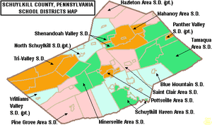
- Blue Mountain School District
- Hazleton Area School District (also in Luzerne County)
- Mahanoy Area School District
- Minersville Area School District
- North Schuylkill School District (also in Columbia County)
- Panther Valley School District (also in Carbon County)
- Pine Grove Area School District
- Pottsville Area School District
- Saint Clair Area School District
- Schuylkill Haven Area School District
- Shenandoah Valley School District
- Tamaqua Area School District
- Tri-Valley School District
- Williams Valley School District (also in Dauphin County)
Communities

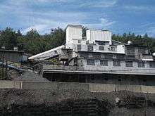
.jpg)
Under Pennsylvania law, there are four types of incorporated municipalities: cities, boroughs, townships, and, in at most two cases, towns. The following cities, boroughs and townships are located in Schuylkill County:
City
- Pottsville (county seat)
Boroughs
- Ashland (partly in Columbia County)
- Auburn
- Coaldale
- Cressona
- Deer Lake
- Frackville
- Gilberton
- Girardville
- Gordon
- Landingville
- Mahanoy City
- McAdoo
- Mechanicsville
- Middleport
- Minersville
- Mount Carbon
- New Philadelphia
- New Ringgold
- Orwigsburg
- Palo Alto
- Pine Grove
- Port Carbon
- Port Clinton
- Ringtown
- Schuylkill Haven
- Shenandoah
- St. Clair
- Tamaqua
- Tower City
- Tremont
Townships
- Barry
- Blythe
- Branch
- Butler
- Cass
- Delano
- East Brunswick
- East Norwegian
- East Union
- Eldred
- Foster
- Frailey
- Hegins
- Hubley
- Kline
- Mahanoy
- New Castle
- North Manheim
- North Union
- Norwegian
- Pine Grove
- Porter
- Reilly
- Rush
- Ryan
- Schuylkill
- South Manheim
- Tremont
- Union
- Upper Mahantongo
- Walker
- Washington
- Wayne
- West Brunswick
- West Mahanoy
- West Penn
Census-designated places
Census-designated places are geographical areas designated by the U.S. Census Bureau for the purposes of compiling demographic data. They are not actual jurisdictions under Pennsylvania law.
- Altamont
- Beurys Lake
- Branchdale
- Brandonville
- Buck Run
- Cumbola
- Delano
- Donaldson
- Englewood
- Forestville
- Fountain Springs
- Friedensburg
- Grier City
- Heckscherville
- Hegins
- Hometown
- Kelayres
- Klingerstown
- Lake Wynonah
- Lavelle
- Locustdale
- Marlin
- McKeansburg
- Muir
- Newtown
- Nuremberg
- Oneida
- Orwin
- Park Crest
- Ravine
- Reinerton
- Renningers
- Seltzer
- Shenandoah Heights
- Sheppton
- Summit Station
- Tuscarora
- Valley View
Unincorporated communities
- Adamsdale
- Aucheys
- Andreas
- Barnesville
- Blackwood
- Boston Run
- Brockton
- Brommerstown
- Brookside
- Clamtown
- Connerton
- Drehersville
- De Turksville
- Frisbie
- Fountain
- Ginthers
- Glen Carbon
- Good Spring
- Haddock
- Hecla
- Hauto
- Irving
- Joliett
- Kepners
- Leibeyville
- Llewellyn
- Locust Valley
- Lofty
- Lorberry
- Mahoning Valley
- Mantzville
- Marstown
- Mary D
- Molino
- Moyers
- Newkirk
- Orwin
- Outwood
- Owl Creek
- Pitman
- Quakake
- Rauschs
- Reedsville
- Reevesdale
- Rene Mont
- Roedersville
- Rough and Ready
- Sacramento
- Seek
- Sheridan
- Snyders
- South Tamaqua
- Stanhope
- Still Creek
- Stonemont
- Suedberg
- Weishample
- Zenners
Population ranking
The population ranking of the following table is based on the 2010 census of Schuylkill County.[44]
† county seat
| Rank | City/Town/etc. | Municipal type | Population (2010 Census) |
|---|---|---|---|
| 1 | † Pottsville | City | 14,324 |
| 2 | Tamaqua | Borough | 7,107 |
| 3 | Schuylkill Haven | Borough | 5,437 |
| 4 | Shenandoah | Borough | 5,071 |
| 5 | Minersville | Borough | 4,397 |
| 6 | Mahanoy City | Borough | 4,162 |
| 7 | Frackville | Borough | 3,805 |
| 8 | Orwigsburg | Borough | 3,099 |
| 9 | St. Clair | Borough | 3,004 |
| 10 | Ashland (partially in Columbia County) | Borough | 2,817 |
| 11 | Lake Wynonah | CDP | 2,640 |
| 12 | McAdoo | Borough | 2,300 |
| 13 | Coaldale | Borough | 2,281 |
| 14 | Pine Grove | Borough | 2,186 |
| 15 | Port Carbon | Borough | 1,889 |
| 16 | Tremont | Borough | 1,752 |
| 17 | Valley View | CDP | 1,683 |
| 18 | Cressona | Borough | 1,651 |
| 19 | Girardville | Borough | 1,519 |
| 20 | Hometown | CDP | 1,349 |
| 21 | Tower City | Borough | 1,346 |
| 22 | Shenandoah Heights | CDP | 1,233 |
| 23 | New Philadelphia | Borough | 1,085 |
| 24 | Palo Alto | Borough | 1,032 |
| 25 | Tuscarora | CDP | 980 |
| 26 | Friedensburg | CDP | 858 |
| 27 | Ringtown | Borough | 818 |
| 28 | Hegins | CDP | 812 |
| 29 | Gilberton | Borough | 769 |
| 30 | Gordon | Borough | 763 |
| 31 | Lavelle | CDP | 742 |
| 32 | Auburn | Borough | 741 |
| 33 | Deer Lake | Borough | 687 |
| 34 | Ravine | CDP | 662 |
| 35 | Marlin | CDP | 661 |
| 36 | Altamont | CDP | 602 |
| 37 | Renningers | CDP | 574 |
| 38 | Park Crest | CDP | 542 |
| 39 | Kelayres | CDP | 533 |
| 40 | Englewood | CDP | 532 |
| 41 | Mechanicsville | Borough | 457 |
| 42 | Muir | CDP | 451 |
| 43 | Cumbola | CDP | 443 |
| 44 | Forestville | CDP | 435 |
| 45 | Nuremberg (partially in Luzerne County) | CDP | 434 |
| 46 | Reinerton | CDP | 424 |
| 47 | Middleport | Borough | 405 |
| 48 | Branchdale | CDP | 388 |
| 49 | Seltzer | CDP | 350 |
| 50 | Delano | CDP | 342 |
| 51 | Donaldson | CDP | 328 |
| 52 | Port Clinton | Borough | 326 |
| 53 | Orwin | CDP | 314 |
| 54 | Fountain Springs | CDP | 278 |
| 55 | New Ringgold | Borough | 276 |
| 56 | Newtown | CDP | 243 |
| 57 | Grier City | CDP | 241 |
| 58 | Sheppton | CDP | 239 |
| 59 | Heckscherville | CDP | 220 |
| 60 | Oneida | CDP | 200 |
| 61 | Brandonville | CDP | 197 |
| 62 | Locustdale (partially in Columbia County) | CDP | 177 |
| 63 | Buck Run | CDP | 176 |
| 64 | Summit Station | CDP | 174 |
| 65 | McKeansburg | CDP | 163 |
| 66 | Landingville | Borough | 159 |
| 67 | Klingerstown | CDP | 127 |
| 68 | Beurys Lake | CDP | 124 |
| 69 | Mount Carbon | Borough | 91 |
Notable people
- Boxing heavyweight great Muhammad Ali had his training camp in Deer Lake.
- Charles Justin Bailey, commanding general of the 81st Division in World War I, was born in Tamaqua on June 21, 1859.
- Gary Becker, 1930–2014, American economist. A professor at the Univ. of Chicago, he was awarded the 1992 Nobel Memorial Prize in Economic Sciences for extending the scope of microeconomic analysis. Sociology, demography, criminology, and other areas of market and nonmarket behavior are included in his work. (born December 2, 1930, Pottsville)
- Francis Brennan, born in Shenandoah (May 7, 1894 – July 2, 1968) was a cardinal of the Catholic Church, Dean of the Sacra Rota Romana 1959–68, and prefect of the Congregation for Divine Worship and the Discipline of the Sacraments 1968. Francis Brennan was the first American to receive an appointment to the Roman Curia, or church court, the highest honor in the Roman Catholic Church.
- Les Brown born Lester Raymond Brown (March 14, 1912 – January 4, 2001) in Reinerton, outside of Tower City, was the American musician and the leader of "Les Brown and the Band of Renown" that toured with Bob Hope for over fifty years.
- Joseph James Bruno, 1883 - 1951, A Republican Party leader, Bank Owner, Several Businesses in Kline Township area, 1920s - 1930s. Father and mother immigrated in 1883 from Calabria, Italy. Joseph was born in Bucita, Italy in 1883. Convicted and pardoned for involvement in "The Kelayres Massacre" a political "parade" that turned deadly on November 5, 1934.[50]
- Walter Ciszek, a Roman Catholic priest, best selling author, and GULAG survivor was born to a Polish-American family in Shenandoah, Pennsylvania. He is currently under investigation for possible Sainthood.
- George Washington Deitzler, Born in Pine Grove, November 30, 1826. Moved to Kansas and became a prominent member of the Free-State Party, Kansas Territorial Speaker of the House of Representatives, Territorial Senator, and Mayor of Lawrence, Kansas. Most notably, he raised the 1st Kansas Volunteer Regiment and was appointed colonel by Kansas Territorial Governor Charles Robinson. He went on to fight in several battles of the Civil War, including Vickburg, but is most famous for his leadership of the Kansas Militia in the Battle of Westport. (Taken from Article by Christopher Alan Edwards, Military Order of the Loyal Legion of the United States, website: suvew.org/mollus)
- Tommy Dorsey and Jimmy Dorsey - famous jazz musicians and bandleaders were born in Shenandoah, Pennsylvania.
- Judge John E. Jones III of the 2005 Kitzmiller v. Dover Area School District intelligent design trial.
- General George Joulwan (retired), was Supreme Allied Commander, Europe, from 1993 to 1997. General Joulwan was born in Pottsville.
- Danny Litwhiler, Major League Baseball Player who played outfield from 1940 to 1951. He was the first Major Leaguer to have an error-free season. He was born in Ringtown.
- The Molly Maguires, a clandestine society of Irish miners who engaged in a violent confrontation with Pennsylvania mining companies in the 19th century.
- John O'Hara - a short story writer, best-selling novelist and National Book Award recipient who brought Pottsville into the national spotlight through his "Gibbsville" stories, accounts of 1920s Pottsville socialites. O'Hara's single family home is located at 606 Mahantongo Street, Pottsville.
- Henry Pleasants (February 16, 1833 – March 26, 1880) was a coal mining engineer and a brigadier general in the Union Army during the American Civil War. He is best known for organizing the building of a tunnel filled with explosives under the Confederate lines outside Petersburg, Virginia, resulting in the Battle of the Crater on July 30, 1864, an opportunity for Union troops to break the defense of Petersburg. He is buried in the Charles Baber Cemetery in Pottsville.
- Darryl Ponicsan was born in Shenandoah, Pennsylvania. Mr. Ponicsan has written a number of novels, like 1973's, Andoshen, Pa, based on his hometown. Among his novels two were made into motion pictures (Cinderella Liberty and The Last Detail). Mr Ponicsan has also written or co-written many screenplays for Hollywood movies, including Vision Quest, Taps, Nuts and Random Hearts. Mr. Ponicsan has been nominated for a number of awards, such as the Golden Globe and the Writer's Guild Award.
- Conrad Richter, a Pulitzer-Prize and National Book Award-winning American novelist. Books written by Richter include The Light in the Forest and The Awakening Land trilogy. He was born in Pine Grove.
- Victor Schertzinger, born in Mahanoy City in 1888, he was a musician who performed with John Philip Sousa and later became a film director and composer. He pioneered the use of original music for films, and his film “One Night of Love” won best musical score and sound recording Oscars in 1934.
- Pottsville Maroons, revolutionary NFL franchise in the 1920s who won the 1925 National Football League Championship only to have it taken away for playing an exhibition game against Notre Dame.
- David Horst, born October 25, 1985 in Pine Grove, Pennsylvania, is an American soccer player currently playing for Houston Dynamo in Major League Soccer
- John Walson, from Mahanoy City, developed the first cable television system in the United States, established in June 1948.
- Brian Reider, publisher of Regular Car Reviews, among YouTube's most popular auto channels, is headquartered in Orwigsburg, PA.
See also
Notes
- In the 1760s, surveyors discovered anthracite coal in the vicinity of Pottsville and Minersville. The survey team was plotting the course of the King’s Highway from Reading to Sunbury. http://portcarbonborough.org/history
References
- "Schuylkill River - Definition of Schuylkill River in US English by Oxford Dictionaries". Oxford Dictionaries - English.
- "State & County QuickFacts". United States Census Bureau. Archived from the original on June 6, 2011. Retrieved November 22, 2013.
- "Find a County". National Association of Counties. Retrieved June 7, 2011.
- The History of Schuylkill County Pa.with Illustrations and Biographical Sketches of some of its Prominent Men and Pioneers, New York:W.W.Munsell and Co., 1881, p. 74
- Ibid.
- DAVIES,JOSEPH H. (CHAIRMAN), ENGLE CHARLES H., YOUNG, ELWOOD M., Area History: A Centennial History - Mahanoy City, (1963), p.9
- Old Schuylkill Tales: A History of Interesting Events, Traditions and ... - Ella Zerbey Elliott - Google Books. Books.google.com. Retrieved on August 15, 2013.
- The Legislation was signed by Governor Simon Snyder on March 18. See, History of Schuylkill County, Munsell, 1881, p.74
- Ibid
- Dives, Pomeroy & Stewart, The History of Schulykill County in Honor of the County's Centenary (1911)
- Hoover, Stephanie (2014). The Kelayres Massacre: Politics and Murder in Pennsylvania's Anthracite Coal Country. History Press.
- King of the Mountain: The Bruno Family Story, Bruce Boyd author, 2016, Ingram Press p. 167
- Day, Sherman, History of Schuylkill County (1843)
- Watson, J.F., Annals of Philadelphia, being a collection of memoirs, anecdotes, and incidents of the city and its inhabitants, Cary and Hart, Philadelphia (1830)
- Munsell, W., History of Schuylkill County, Macnamara, New York (1881)
- Pennsylvania Abstract, 1975 and Annual Coal Report 2016, USEIA (November 2017)
- Annual Coal Report 2016, USEIA (November 2017)
- The Pocono Record, The Citizens’ Voice, Anthracite mining remains vital in northeast Pa. by Elizabeth Skrapits, June 12, 2015
- Munsell, W., History of Schuylkill County, Macnamara, New York (1881), pp. 80-81
- Ibid, p. 46
- "Tamaqua Railroad Station - History". www.tamaquastation.com.
- USDA, Census of Agriculture Schuylkill County Profile (2012)
- Pottsville Republican, Business successes wax, wane: Van Heusen heyday recalled in Schuylkill by L.L. Ward, (December 3, 1994)
- Lehighton Times-News-Record, Death of an industry giant, Donald R. Serfass (April 26, 2013)
- Smith Jr., J. K., Dublin, T., Hardy III, C., & Pencak W. (2011). A diversity of industries. See Explore Pennsylvania History
- McGuigan, M. (Producer), & Migliore, M. (Director). (2008). A Shop on every corner: Memories of the garment industry [Motion picture]. United States: Poetic Stage Productions
- U.S. Census Bureau. (2011). County Business Patterns (NAICS): United States Manufacturing 1999, 2005, 2011 [Data files]
- "2010 Census Gazetteer Files". United States Census Bureau. August 22, 2012. Retrieved March 10, 2015.
- "Population and Housing Unit Estimates". Retrieved May 21, 2020.
- "U.S. Decennial Census". United States Census Bureau. Retrieved March 10, 2015.
- "Historical Census Browser". University of Virginia Library. Retrieved March 10, 2015.
- Forstall, Richard L., ed. (March 24, 1995). "Population of Counties by Decennial Census: 1900 to 1990". United States Census Bureau. Retrieved March 10, 2015.
- "Census 2000 PHC-T-4. Ranking Tables for Counties: 1990 and 2000" (PDF). United States Census Bureau. April 2, 2001. Retrieved March 10, 2015.
- "U.S. Census website". United States Census Bureau. Retrieved January 31, 2008.
- Pennsylvania Department of Health, Birth Age County Reports 1990, 1990
- Pennsylvania Department of Health, Birth Age County Reports 2000, 2000
- Pennsylvania Department of Health, Birth Age County Reports 2011, 2011
- Center for Rural Pennsylvania, Number of Children Decreasing in Rural Pennsylvania, 2011
- Robert Wood Johnson Foundation (2016). "Pennsylvania Teen Births 2015".
- US Census Bureau (2015). "Poverty Rates by County Small Area Income and Poverty Estimates".
- Pennsylvania Budget and Policy Center (2012). "Student Poverty Concentration 2012".
- "Office of Management and Budget". The White House.
- "Archived copy". Archived from the original on September 24, 2015. Retrieved December 7, 2017.CS1 maint: archived copy as title (link)
- Bureau, US Census. "Decennial Census by Decades". www.census.gov.
- Commonwealth of Pennsylvania Department of State. "November 2008 Voter Registration Statistics". Archived from the original (XLS) on November 26, 2008. Retrieved November 3, 2008.
- "Home".
- "Pennsylvania 2016 Presidential And State Election Results". NPR.org. Retrieved June 25, 2019.
- Center, Legislativate Data Processing. "Find Your Legislator". The official website for the Pennsylvania General Assembly. Retrieved April 26, 2017.
- "Dave Leip's Atlas of U.S. Presidential Elections". uselectionatlas.org.
- King of the Mountain: The Bruno Family Story, Bruce Boyd author, 2016, Ingram Press
External links
Places adjacent to Schuylkill County, Pennsylvania | ||||||||||
|---|---|---|---|---|---|---|---|---|---|---|
| ||||||||||
| Authority control |
|
|---|