Carbon County, Pennsylvania
Carbon County is a county located in the U.S. state of Pennsylvania. As of the 2010 census, the population was 65,249.[2] Its county seat is Jim Thorpe,[3] which was founded in 1818 as Mauch Chunk, a company town of the Lehigh Coal & Navigation Company (LC&N) along a new wagon road the company was constructing nine miles long[4] to their coal mine, in the area now known as Summit Hill.[5] LC&N also constructed the Lehigh Canal navigations during this time in the area.[6]
Carbon County | |
|---|---|
 Blue Mountain near Palmerton | |
 Location within the U.S. state of Pennsylvania | |
 Pennsylvania's location within the U.S. | |
| Coordinates: 40°55′N 75°42′W | |
| Country | |
| State | |
| Founded | March 13, 1843 (Divided from Northampton County |
| Named for | Coal deposits |
| Seat | Jim Thorpe |
| Largest borough | Lehighton |
| Area | |
| • Total | 387 sq mi (1,000 km2) |
| • Land | 381 sq mi (990 km2) |
| • Water | 5.9 sq mi (15 km2) 2%% |
| Population | |
| • Estimate (2018) | 64,227 |
| • Density | 168/sq mi (65/km2) |
| Time zone | UTC−5 (Eastern) |
| • Summer (DST) | UTC−4 (EDT) |
| Congressional district | 9th |
| Website | carboncounty |
| Designated | June 13, 1982[1] |
In 1827, that wagon road became the nation's second operating railroad,[4] the Summit Hill & Mauch Chunk Railroad which is regarded as the world's first roller coaster,[6] which became its main function between 1873–1931. The area around Mauch Chunk was known as the "Switzerland of America", the long wide slack water pool above the Lehigh's upper dam being surrounded by Mauch Chunk Ridge, Bear Mountain, Pisgah Ridge, Mount Pisgah, Nesquehoning Ridge, Broad Mountain and their various prominences and summits. Another railroad first, the first railway to operate steam locomotives as traction engines and prime movers in the United States was the Beaver Meadows Railroad, which connected from mines west of Beaver Meadows and Weatherly on the opposite side of Broad Mountain along a water path through the Lehigh Gorge at Penn Haven Junction (once supporting five railroads) to the Lehigh Canal opposite Lehighton.
In the 1830s, the first blast furnaces in Northampton County were built by the LC&N in an attempt to make anthracite iron, the foundation of the early industrial revolution in America. The LC&N also built the first wire rope factory in the U.S. in Mauch Chunk.
Carbon County is included in the Allentown–Bethlehem–Easton, PA–NJ Metropolitan Statistical Area. However, the Lehigh Valley directly borders the Delaware Valley, and Carbon County is included in Philadelphia's Designated Media Market. It is considered part of the state's Coal Region, though the eastern and northeastern sections are considered part of the Pocono Mountains—since they are east of the Lehigh River, the demarcation arbitrarily separating very similar mountain ridge and valley systems.
Geography

According to the U.S. Census Bureau, the county has a total area of 387 square miles (1,000 km2), of which 381 square miles (990 km2) is land and 5.9 square miles (15 km2) (1.5%) is water.[7] Blue Mountain forms the southern boundary of Carbon. The northeast area of the county is located in the Pocono Mountains and the northwest area includes portions of Broad and Spring mountains. It is drained by the Lehigh River except for a small area in western Packer Township and the borough of Lansford that are drained by the Still Creek and Panther Creek, respectively, into the Little Schuylkill River and the Schuylkill River, and the Audenried area in the northwest corner that drains into the Susquehanna River via the Catawissa Creek. The Lehigh cuts a gorge between Jim Thorpe and White Haven which hosts the Lehigh Gorge State Park.
Climate
Carbon County has a humid continental climate (Dfa/Dfb) and is mostly in hardiness zone 6a, except for 6b in some southern lowlands and 5b in some northern highlands. Average monthly temperatures at Jake Arner Memorial Airport range from 27.8 °F in January to 72.5 °F in July, while at the Pocono interchange of the Turnpike they range from 22.9 °F in January to 68.3 °F in July.
Adjacent counties
- Luzerne County (north)
- Monroe County (east)
- Northampton County (southeast)
- Lehigh County (south)
- Schuylkill County (southwest)
Transportation
Major highways
Buses
Carbon County Community Transit fixed-route bus service consists of the Lynx 1 (Nesquehoning-Lehigh Valley Mall), Lynx 2 (Nesquehoning-Walnutport), and Lynx 3 (Nesquehoning-Tamaqua/Hometown). Also, Hazleton Public Transit (HPT) bus route 30 serves northwestern Carbon County via Beaver Meadows and Junedale to Weatherly. Audenried is served by HPT route 20 (Hazleton-McAdoo/Kelayres). Fullington Trailways provides intercity service to Carbon County with stops in Lehighton and Jim Thorpe. Service to Jim Thorpe is suspended due to construction on US 209. Martz Trailways has a stop in Kidder Township near the Pocono interchange of Interstate 476 for service between Scranton, Wilkes-Barre, Allentown, Quakertown, and Philadelphia. This is an Amtrak Thruway Motorcoach route, connecting to Amtrak trains at 30th Street Station in Philadelphia. Martz also operates casino bus routes to Atlantic City from the stop.
Airports
Jake Arner Memorial Airport is in Mahoning Township and provides general aviation. The nearest commercial passenger service is at Lehigh Valley International Airport or Wilkes-Barre/Scranton International Airport.
History
Carbon County was created on March 13, 1843 from parts of Northampton and Monroe Counties and was named for the extensive deposits of anthracite coal in the region, where it was first discovered (1791) and early attempts were made to exploit the deposits by the Lehigh Coal Mine Company (1792), whose expeditions broke trail and pioneered river bank sites using mule animal powered technology to log, saw, and build arks to carry bags of coal to Philadelphia, with only scant success.
The first settlement in Carbon County was the Moravian mission Gnadenhutten, established in 1745 in the Northampton County of the day. Deeply moved by the deplorable state of the Leni Lenape Indians in America, twelve Moravian missionaries left their home in Herrnhut Germany and traveled by sea to the wilderness of Pennsylvania, a place known for religious tolerance under the auspices of Count Zinzendorf. Located where Lehighton now stands, Gnadenhutten exemplified communal simplicity. Home to hundreds of Lenni Lenape (Delaware) and Mahican Indians displaced by white settlements, predation, bigotry and subjugation to the Iroquois, the Delaware peoples were being squeezed out of the southern counties and New Jersey westwards and against the Blue Ridge escarpment. The mission was a scene of quiet, humble and unobtrusive heroism and the Indians' shelter. Although the wilderness of Carbon County was quite treacherous, the Moravians traveled in the wilds of Carbon County undaunted. By 1752, increased hostility put Gnadenhutten at risk for attack, but the missionaries' pious good works did not go unnoticed. The frankness and earnestness of the simple Moravians had won respect with the many tribes of Pennsylvania Indians, and they lived without incident until 1755.[8] At that point an Amerindian uprising drove settlements away from the Lehigh Gap, and whites didn't re-enter the area before the late 1780s according to Brenckman.[4] In 1791, a homesteader, Phillip Ginter hunting on 'Sharp Mountain' along Pisgah Ridge[9] found a black 'stone coal' outcropping, and conveyed a chunk of it to Weissport, PA. (For a more complete set of details & events, see Lehigh Canal and Lehigh Coal & Navigation Company articles.)
Lehigh Coal Mine Company (LCMC) operations had managed to fell many trees and open up the mouth area of the Nesquehoning Creek by 1800. This area became known as Lausanne, or Lausanne Landing, after the Inn & Tavern built there called the "Landing Tavern". An Amerindian trail, crossed the stream near the confluence with Jean's Run[10] and the camp grounds of their boat builders, climbing northwestwards along a traverse to the next water gap west, eroded into the southern flank of Broad Mountain (Lehigh Valley). Connecting across the barrier ridge it had just climbed to another valley whose waters originated in the saddle-pass in which Hazleton, Pennsylvania was built, the trail would become the 'Lausanne-Nescopeck road' (mule trail), then the Lehigh & Susquehanna Turnpike in 1804. Today, PA 93 follows this route in the main, save where modern road building capabilities allowed improved positioning. This road cut off 90–100 miles (140–160 km) from a trip from Philadelphia to the Wyoming Valley and the northern sections of the Coal Region.
Carbon County is the location of the trials and executions of the controversial Molly Maguires, an Irish secret society that had been accused of terrorizing the region.
Carbon County has a rich history. Some interesting people have passed through her mountains, including the Moravian mystic Count Zinzendorf, Benjamin Gilbert, John James Audubon, Benjamin Franklin, and many more.
Blessed with a unique geography, Carbon County dazzled the adventurous travelers of the Victorian era, just as it attracts adventurers today. Aesthetically not much has changed of this unique landscape; written in 1877, the following passage is still valid today: "Such rough and tumble experience, climbing mountains, falling over rocks, exploring wild ravines, diving into coal mines, and riding on every description of conveyance which it has entered into the mind of man to run on." Home of the Lehigh Gorge State Park, Carbon County is an ideal place for hikers, cyclists, history buffs and adventurers.[8]
Demographics
| Historical population | |||
|---|---|---|---|
| Census | Pop. | %± | |
| 1850 | 15,686 | — | |
| 1860 | 21,033 | 34.1% | |
| 1870 | 28,144 | 33.8% | |
| 1880 | 31,923 | 13.4% | |
| 1890 | 38,624 | 21.0% | |
| 1900 | 44,510 | 15.2% | |
| 1910 | 52,846 | 18.7% | |
| 1920 | 62,565 | 18.4% | |
| 1930 | 63,380 | 1.3% | |
| 1940 | 61,735 | −2.6% | |
| 1950 | 57,558 | −6.8% | |
| 1960 | 52,889 | −8.1% | |
| 1970 | 50,573 | −4.4% | |
| 1980 | 53,285 | 5.4% | |
| 1990 | 56,846 | 6.7% | |
| 2000 | 58,802 | 3.4% | |
| 2010 | 65,249 | 11.0% | |
| Est. 2018 | 64,227 | [11] | −1.6% |
| U.S. Decennial Census[12] 1790-1960[13] 1900-1990[14] 1990-2000[15] 2010-2017[2] | |||
As of the census[16] of 2000, there were 58,802 people, 23,701 households, and 16,424 families residing in the county. The population density was 154 people per square mile (60/km²). There were 30,492 housing units at an average density of 80 per square mile (31/km²). The racial makeup of the county was 97.82% White, 0.60% Black or African American, 0.16% Native American, 0.31% Asian, 0.03% Pacific Islander, 0.32% from other races, and 0.76% from two or more races. 1.46% of the population were Hispanic or Latino of any race. 29.4% were of German, 10.1% Irish, 9.2% Italian, 7.9% American, 6.6% Slovak, 6.0% Polish and 5.8% Ukrainian ancestry.
There were 23,701 households out of which 28.70% had children under the age of 18 living with them, 54.80% were married couples living together, 9.90% had a female householder with no husband present, and 30.70% were non-families. 26.00% of all households were made up of individuals and 13.50% had someone living alone who was 65 years of age or older. The average household size was 2.44 and the average family size was 2.93.
In the county, the population was spread out with 22.20% under the age of 18, 6.90% from 18 to 24, 28.30% from 25 to 44, 24.20% from 45 to 64, and 18.50% who were 65 years of age or older. The median age was 41 years. For every 100 females there were 94.90 males. For every 100 females age 18 and over, there were 92.30 males.
- Birth rate
Carbon County's live birth rate was 646 births in 1990. Carbon County live birth rate in 2000 declined to 566 births, while in 2011 it rose to 586 babies.[17] Over the past 50 years (1960 to 2010), rural Pennsylvania saw a steady decline in both the number and proportion of residents under 18 years old. In 1960, 1.06 million rural residents, or 35 percent of the rural population, were children. According to data from the Pennsylvania Department of Health, in 1990, the Commonwealth of Pennsylvania's birth rate was 171,053.[18] In 2000, Pennsylvania's birth rate was 145,874.[19] Finally in 2011, the State's birth rate declined further to 142,021.[20] From 2000 to 2009, the number of babies born in rural counties declined 5 percent.[21] Urban counties have also experienced a decline in the number of school aged children. From 2000-2010 urban Pennsylvania counties had a 3 percent decline in the number of residents under 18 years old. In 2010, there were 2.07 million residents, or 22 percent of the urban population, who were under age 18.[22]
Law and government
| Year | Republican | Democratic | Third parties |
|---|---|---|---|
| 2016 | 64.7% 18,743 | 30.8% 8,936 | 4.5% 1,314 |
| 2012 | 52.6% 13,504 | 45.1% 11,580 | 2.4% 610 |
| 2008 | 47.9% 12,957 | 49.8% 13,464 | 2.3% 629 |
| 2004 | 50.0% 12,519 | 48.8% 12,223 | 1.2% 301 |
| 2000 | 45.7% 9,717 | 50.1% 10,668 | 4.2% 892 |
| 1996 | 36.3% 7,193 | 47.7% 9,457 | 16.0% 3,179 |
| 1992 | 33.4% 7,243 | 41.9% 9,072 | 24.7% 5,344 |
| 1988 | 52.4% 10,232 | 46.6% 9,104 | 1.1% 211 |
| 1984 | 54.4% 10,701 | 44.9% 8,836 | 0.7% 131 |
| 1980 | 52.0% 10,042 | 41.4% 8,009 | 6.6% 1,278 |
| 1976 | 44.5% 8,883 | 54.0% 10,791 | 1.5% 299 |
| 1972 | 59.1% 11,639 | 39.4% 7,774 | 1.5% 299 |
| 1968 | 46.1% 9,954 | 49.3% 10,634 | 4.6% 991 |
| 1964 | 32.0% 7,309 | 67.5% 15,416 | 0.5% 116 |
| 1960 | 50.3% 12,586 | 49.5% 12,391 | 0.2% 55 |
| 1956 | 57.3% 13,150 | 42.3% 9,722 | 0.4% 89 |
| 1952 | 53.4% 12,283 | 46.0% 10,571 | 0.6% 134 |
| 1948 | 49.8% 9,744 | 48.2% 9,438 | 2.0% 396 |
| 1944 | 46.9% 9,837 | 52.7% 11,060 | 0.4% 73 |
| 1940 | 45.3% 10,618 | 54.5% 12,777 | 0.3% 60 |
| 1936 | 43.8% 11,298 | 54.9% 14,179 | 1.3% 334 |
| 1932 | 48.5% 9,918 | 48.3% 9,874 | 3.2% 649 |
| 1928 | 65.0% 15,047 | 34.6% 8,010 | 0.4% 98 |
| 1924 | 55.6% 10,236 | 28.0% 5,150 | 16.5% 3,041 |
| 1920 | 59.2% 7,900 | 37.7% 5,030 | 3.1% 416 |
| 1916 | 49.2% 4,275 | 47.2% 4,099 | 3.7% 319 |
| 1912 | 14.0% 1,246 | 40.9% 3,652 | 45.2% 4,036[24] |
| 1908 | 49.2% 4,486 | 42.7% 3,890 | 8.1% 737 |
| 1904 | 53.9% 4,505 | 35.9% 2,998 | 10.2% 850 |
| 1900 | 48.8% 4,222 | 48.0% 4,149 | 3.2% 278 |
| 1896 | 53.9% 4,534 | 42.9% 3,609 | 3.1% 264 |
| 1892 | 45.7% 3,179 | 50.9% 3,541 | 3.4% 239 |
| 1888 | 45.7% 3,279 | 51.1% 3,665 | 3.3% 233 |

Carbon County has long been considered a bellwether county for Pennsylvania statewide elections. In gubernatorial elections, it was perfect from 1952 to 2014.[25][26][27] At the presidential level, Carbon County was also a bellwether for Pennsylvania (although not the nation) until recently, with only 1 miss (in 1960) from 1916 to 2000, and with a margin within 3.5 points of the statewide margin in every election from 1940 to 2000 except 1964 (5.3% more Democratic) and 1976 (6.9% more Democratic). However, since then the county has trended Republican relative to the state as a whole, with McCain outperforming in Carbon by 8.5% relative to the state and Romney outperforming by 12.9%. Republicans hold the commissioner majority while Democrats hold all county row offices. Al Gore carried it in 2000, and in 2004, Republican George W. Bush defeated Democrat John Kerry 49.99% to 48.81% or a margin of 296 votes.[28]
County commissioners
- Wayne Nothstein, Chairman, Republican
- Chris Lukasevich, Republican
- Rocky Ahner, Democratic[29]
State Senate
- John Yudichak, Independent, Pennsylvania's 14th Senatorial District
- Dave Argall, Republican, Pennsylvania's 29th Senatorial District
State House of Representatives
- Doyle Heffley, Republican, Pennsylvania's 122nd Representative District
- Jerry Knowles, Republican, Pennsylvania's 124th Representative District
United States House of Representatives
United States Senate
- Pat Toomey, Republican
- Bob Casey, Democrat
Education
Community, junior and technical colleges
- Lehigh Carbon Community College – Carbon Campus, Jim Thorpe
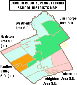
Public school districts
- Hazleton Area School District (also in Luzerne and Schuylkill Counties)
- Jim Thorpe Area School District
- Lehighton Area School District
- Palmerton Area School District
- Panther Valley School District (also in Schuylkill County)
- Weatherly Area School District
- There are 13 public cyber charter schools (2016) in Pennsylvania that are available for free statewide, to children K-12.[30] See: Education in Pennsylvania.
Career Tech School
Carbon Career & Technical Institute public school located in Jim Thorpe
Intermediate Unit
The public and private K-12 schools in Carbon County are served by Carbon-Lehigh Intermediate Unit 21.[31]
Recreation
Mauch Chunk Lake is a county-run park that offers swimming, camping, hiking and cross country skiing in the winter. There are three Pennsylvania state parks in Carbon County.
- Beltzville State Park
- Lehigh Gorge State Park stretches along the Lehigh River in Luzerne County and into Carbon County.
- Hickory Run State Park
Municipalities

Under Pennsylvania law, there are four types of incorporated municipalities: cities, boroughs, townships, and, in the case of Bloomsburg, a town. The following boroughs and townships are located in Carbon County:
Boroughs
Townships
Census-designated places
Census-designated places are geographical areas designated by the U.S. Census Bureau for the purposes of compiling demographic data. They are not actual jurisdictions under Pennsylvania law. Other unincorporated communities, such as villages, may be listed here as well.
Former communities
- Lausanne Landing (Old Lausanne Township) – The original settlement above the Lehigh Gap at the mouth of the Nesquehoning Creek; terminus of the Lehigh & Susquehanna Turnpike founded in 1804.
- Big Creek Valley
- East Penn Township, Pennsylvania – the far eastern part of today's Jim Thorpe at the other end of Bear Mountain (Lehigh Valley).
- Historic Mauch Chunk (now Jim Thorpe, since 1952 merger)
- East Mauch Chunk (now an eastern part of Jim Thorpe), Pennsylvania
Population ranking
The population ranking of the following table is based on the 2010 census of Carbon County.[32]
† county seat
| Rank | City/Town/etc. | Municipal type | Population (2010 Census) |
|---|---|---|---|
| 1 | Lehighton | Borough | 5,500 |
| 2 | Palmerton | Borough | 5,414 |
| 3 | † Jim Thorpe | Borough | 4,781 |
| 4 | Indian Mountain Lake (partially in Monroe County) | CDP | 4,372 |
| 5 | Lansford | Borough | 3,941 |
| 6 | Nesquehoning | Borough | 3,349 |
| 7 | Summit Hill | Borough | 3,034 |
| 8 | Weatherly | Borough | 2,525 |
| 9 | Towamensing Trails | CDP | 2,292 |
| 10 | Weissport East | CDP | 1,624 |
| 11 | Bowmanstown | Borough | 937 |
| 12 | Tresckow | CDP | 880 |
| 13 | Beaver Meadows | Borough | 869 |
| 14 | Parryville | Borough | 525 |
| 15 | Holiday Pocono | CDP | 476 |
| 16 | Weissport | Borough | 412 |
| 17 | East Side | Borough | 317 |
| 18 | Albrightsville | CDP | 202 |
PennEast Pipeline
The proposed PennEast Pipeline will pass through the county adversely impacting many property owners and community tax revenues.[33][34] Unlike other states, under Pennsylvania state tax policy, natural gas and oil pipelines are exempted from property taxes.[35] Pipeline companies prohibit development within the 100 foot wide right-of-way, there by limiting future development options for the landowner. This limits future potential property tax revenues for the school district, by constraining future land development. Located in the marcellus shale region, Carbon County is adversely impacted this way.[36][37][38]
The Carbon County Planning Commission and Carbon County Commissioners have stated opposition to the pipeline project.[39] The pipeline adversely impacts: Penn Forest Township, Kidder Township, Towamensing Township and Lower Towamensing Township. The Township Supervisors in all four townships passed resolutions opposing the pipeline.
Notable people
See also
References
- "PHMC Historical Markers Search" (Searchable database). Pennsylvania Historical and Museum Commission. Commonwealth of Pennsylvania. Retrieved January 25, 2014.
- "State & County QuickFacts". United States Census Bureau. Retrieved November 16, 2013.
- "Find a County". National Association of Counties. Archived from the original on May 31, 2011. Retrieved June 7, 2011.
- Fred Brenckman, Official Commonwealth Historian (1884). HISTORY OF CARBON COUNTY PENNSYLVANIA (2nd (1913) ed.). Also Containing a Separate Account of the Several Boroughs and Townships in the County, J. Nungesser, Harrisburg, PA (1913 edition, Archive.org project e-reprint).
- When the LC&N began operations on the LCMC holdings, both Summit Hill and Mauch Chunk were part of the township of Lausanne. As the years went by, the township of Lausanne, Pennsylvania always seems to have kept the less settled and wilder lands to itself as home rule petitions under the Pennsylvania Constitution spawned new organized communities exercising self rule. Consequently, Lausanne's geographical center continually moved north, until today's small strip of land is all that is left of a township which covered the territory which was most of today's Carbon County.
- Bartholomew, Ann M.; Metz, Lance E.; Kneis, Michael (1989). DELAWARE and LEHIGH CANALS (First ed.). Oak Printing Company, Bethlehem, Pennsylvania: Center for Canal History and Technology, Hugh Moore Historical Park and Museum, Inc., Easton, Pennsylvania. p. 4. ISBN 0930973097. LCCN 89-25150.
- "2010 Census Gazetteer Files". United States Census Bureau. August 22, 2012. Retrieved March 5, 2015.
- Rebecca M. Rabenold-Finsel, Carbon County: Postcard History (South Carolina: Arcadia Publishing 2004), 9.
- The 'reasonably local Sharp Mountain of today is the same ridge, but is geographically limited by modern USGS conventions to the part west of the Little Schuylkill River's water gap. The Sharp Mountain SUMMIT, was a peak near Summit Hill, Pennsylvania, now leveled by mining activity.
- Jean's Run is the first left bank tributary of Nesquehoning Creek, upstream from the latter's mouth on the Lehigh River. It has three falls and steep ravine sides, so was not a valley congenial to wagon travel, nor likely friendly to climbing with pack mules without great care and persuasion. The toll house for the turnpike, nonetheless was located nearby opposite the mouth of the Run, and PA 93 crosses today from an elevated bridge, so the Turnpike climbed from Jean's Run across the slope to the same level as the Broad Mountain side of today's bridge.
- "Population and Housing Unit Estimates". Retrieved October 16, 2018.
- "U.S. Decennial Census". United States Census Bureau. Retrieved March 5, 2015.
- "Historical Census Browser". University of Virginia Library. Retrieved March 5, 2015.
- Forstall, Richard L., ed. (March 24, 1995). "Population of Counties by Decennial Census: 1900 to 1990". United States Census Bureau. Retrieved March 5, 2015.
- "Census 2000 PHC-T-4. Ranking Tables for Counties: 1990 and 2000" (PDF). United States Census Bureau. April 2, 2001. Retrieved March 5, 2015.
- "U.S. Census website". United States Census Bureau. Retrieved 2008-01-31.
- Pennsylvania Department of Health, Birth Age County Reports 1990 and 2011, 2011
- Pennsylvania Department of Health, Health Statistics - Resident Live Birth rate by county, 1990
- Pennsylvania Department of Health, Health Statistics - Resident Live Birth rate by county, 2000
- Pennsylvania Department of Health, Health Statistics - Resident Live Birth rate by county, 2013
- Center for Rural Pennsylvania, Number of Children Decreasing, Number of Seniors Increasing in Rural Pennsylvania, July 2011
- Pennsylvania Department of Health, Birth Statistics, 2013
- Leip, David. "Dave Leip's Atlas of U.S. Presidential Elections". uselectionatlas.org.
- The leading "other" candidate, Progressive Theodore Roosevelt, received 3,549 votes, while Socialist candidate Eugene Debs received 428 votes, Prohibition candidate Eugene Chafin received 57 votes, and Socialist Labor candidate Arthur Reimer received 2 votes.
- "Carbon County New Bellwether for Governor". Pittsburgh Press. Press Harrisburg Bureau. 6 November 1978. Retrieved 14 August 2016.
- "The bellwethers: What do voters in eastern PA know that the rest don't?". PennLive. 3 November 2014. Retrieved 14 August 2016.
- "2014 General Election Official Returns". Pennsylvania Department of State. Retrieved 14 August 2016.
- http://uselectionatlas.org/RESULTS/statesub.php?year=2004&fips=42025&off=0&elect=0&f=0
- "Carbon County Commissioners". Retrieved August 14, 2016.
- Pennsylvania Department of Education (2016). "Charter Schools".
- PDE (2016). "MAP OF PENNSYLVANIA SCHOOL DISTRICTS AND INTERMEDIATE UNITS".
- "2010 U.S. Census website". United States Census Bureau. Retrieved February 10, 2013.
- UGI PennEast Pipeline Co. LLC (2014). "PennEast Pipeline map".
- Tom Ragan (February 12, 2015). "Federal agency hears both sides of pipeline debate". Standard Speaker.
- Katie Colaneri (June 11, 2015). "New pipeline could mean tax bonanza for NJ towns, but for Pa.? Not so much". State Impact NPR.org.
- The Nature Conservancy – Pennsylvania Chapter, Natural Gas Pipelines Pennsylvania Energy Impacts Assessment, December 16, 2011
- The Nature Conservancy, Marcellus Shale Gas Development in Bradford County, December 16, 2011
- Timothy Puko (December 11, 2011). "Shale gas pipelines pose challenges to state's forests, wildlife". TribLive.com.
- Amy Miller (February 18, 2016). "Carbon County planner raises concerns over pipeline". Times News Online.
External links
| Wikimedia Commons has media related to Carbon County, Pennsylvania. |
| Wikivoyage has a travel guide for Carbon County. |
- Carbon County official website
- "Famous people from the Lehigh Valley", The Allentown Morning Call
Municipalities and communities of Carbon County, Pennsylvania, United States | ||
|---|---|---|
| Boroughs | | |
| Townships | ||
| CDPs | ||
| Unincorporated communities | ||
| Footnotes | ‡This populated place also has portions in an adjacent county or counties | |
| Authority control |
|
|---|