Columbia County, Pennsylvania
Columbia County is a county located in the U.S. state of Pennsylvania. As of the 2010 census, the population was 67,295.[2] Its county seat is Bloomsburg.[3] The county was created on March 22, 1813, from part of Northumberland County and named for Columbia, a poetic name for the United States that alludes to Christopher Columbus.
Columbia County | |
|---|---|
County | |
| Columbia County | |
 The Columbia County courthouse in Bloomsburg | |
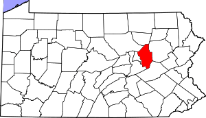 Location within the U.S. state of Pennsylvania | |
 Pennsylvania's location within the U.S. | |
| Coordinates: 41°03′N 76°24′W | |
| Country | |
| State | |
| Founded | March 22, 1813 |
| Named for | Christopher Columbus |
| Seat | Bloomsburg |
| Largest town | Bloomsburg |
| Area | |
| • Total | 490 sq mi (1,300 km2) |
| • Land | 483 sq mi (1,250 km2) |
| • Water | 7.1 sq mi (18 km2) 1.4% |
| Population | |
| • Estimate (2018) | 65,456 |
| • Density | 138/sq mi (53/km2) |
| Time zone | UTC−5 (Eastern) |
| • Summer (DST) | UTC−4 (EDT) |
| Congressional district | 9th |
| Website | www |
| Designated | July 11, 1983[1] |
Columbia County is part of the Bloomsburg-Berwick, PA Metropolitan Statistical Area.
Geography

According to the U.S. Census Bureau, the county has a total area of 490 square miles (1,300 km2), of which 483 square miles (1,250 km2) is land and 7.1 square miles (18 km2) (1.4%) is water.[4] The southern tip of Columbia County is part of the Coal Region. The area of the county from the Susquehanna River south to several miles south of Numidia is mostly farmland and state game lands. Around the Susquehanna River, there are several communities, such as Bloomsburg and Catawissa. From the Susquehanna River north as far as Waller, the county is mostly farmland with several patches of forest. North of Waller, the county is mostly state game lands and mountains.[5]
The major streams in Columbia County are the Susquehanna River, Fishing Creek, Briar Creek, Catawissa Creek, and Roaring Creek.[5]
The county has a humid continental climate (Dfa/Dfb) and average monthly temperatures in Bloomsburg average from 26.9 °F in January to 72.4 °F in July.
Mountains
Note: Only mountains higher than 1,500 feet (460 m) are listed
| Name | Height | Image | |
|---|---|---|---|
| Red Rock Mountain | 2,365 feet (721 m) |  | |
| Central Mountain | 2,247 feet (685 m) | ||
| Chimneystack Rock | 2,244 feet (684 m) | ||
| Buck Mountain | 1,942 feet (592 m) | 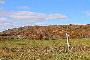 | |
| Catawissa Mountain | 1,873 feet (571 m) |  | |
| Big Mountain | 1,811 feet (552 m) | ||
| Knob Mountain | 1,752 feet (534 m) | 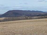 | |
| Nescopeck Mountain | 1,604 feet (489 m) | 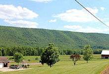 | |
| Lee Mountain | 1,594 feet (486 m) |  | |
| McCauley Mountain | 1,571 feet (479 m) |  |
Major highways
Adjacent counties
- Sullivan County (north)
- Luzerne County (east)
- Schuylkill County (southeast)
- Northumberland County (southwest)
- Montour County (west)
- Lycoming County (northwest)
State park
Part of Ricketts Glen State Park is in the northern portion of Columbia County.[8]
Demographics
| Historical population | |||
|---|---|---|---|
| Census | Pop. | %± | |
| 1820 | 17,621 | — | |
| 1830 | 20,059 | 13.8% | |
| 1840 | 24,267 | 21.0% | |
| 1850 | 17,710 | −27.0% | |
| 1860 | 25,065 | 41.5% | |
| 1870 | 28,766 | 14.8% | |
| 1880 | 32,409 | 12.7% | |
| 1890 | 36,832 | 13.6% | |
| 1900 | 39,896 | 8.3% | |
| 1910 | 48,467 | 21.5% | |
| 1920 | 48,349 | −0.2% | |
| 1930 | 48,803 | 0.9% | |
| 1940 | 51,413 | 5.3% | |
| 1950 | 53,460 | 4.0% | |
| 1960 | 53,489 | 0.1% | |
| 1970 | 55,114 | 3.0% | |
| 1980 | 61,967 | 12.4% | |
| 1990 | 63,202 | 2.0% | |
| 2000 | 64,148 | 1.5% | |
| 2010 | 67,295 | 4.9% | |
| Est. 2018 | 65,456 | [9] | −2.7% |
| U.S. Decennial Census[10] 1790-1960[11] 1900-1990[12] 1990-2000[13] 2010-2017[2] | |||
As of the census[14] of 2000, there were 64,151 people, 24,915 households, and 16,568 families residing in the county. The population density was 132 people per square mile (51/km2). There were 27,733 housing units at an average density of 57 per square mile (22/km2). The racial makeup of the county was 97.59% White, 0.80% Black or African-American, 0.15% Native American, 0.52% Asian, 0.03% Pacific Islander, 0.33% from other races, and 0.58% from two or more races. 0.95% of the population were Hispanic or Latino of any race. 33.2% were of German, 10.0% American, 9.4% Irish, 8.1% Italian, 6.7% Polish and 6.2% English ancestry.
There were 24,915 households, out of which 27.70% had children under the age of 18 living with them, 53.80% were married couples living together, 8.70% had a female householder with no husband present, and 33.50% were non-families. 26.60% of all households were made up of individuals, and 11.80% had someone living alone who was 65 years of age or older. The average household size was 2.42 and the average family size was 2.90.
In the county, the population was spread out, with 20.80% under the age of 18, 14.30% from 18 to 24, 25.90% from 25 to 44, 23.10% from 45 to 64, and 15.90% who were 65 years of age or older. The median age was 38 years. For every 100 females, there were 90.80 males. For every 100 females age 18 and over, there were 87.80 males.
Metropolitan Statistical Area
The United States Office of Management and Budget[15] has designated Columbia County as the Bloomsburg-Berwick, PA Metropolitan Statistical Area (MSA). As of the 2010 census[16] the metropolitan area ranked 20th most populous in the State of Pennsylvania and the 368th most populous in the United States with a population of 82,562. Columbia County is also a part of the larger Bloomsburg-Berwick-Sunbury, PA Combined Statistical Area (CSA), which combines the populations of Columbia County as well as Montour, Northumberland, Snyder and Union Counties in Pennsylvania. The Combined Statistical Area ranked 8th in the State of Pennsylvania and 115th most populous in the United States with a population of 264,739.
Politics and government
| Year | Republican | Democratic | Third parties |
|---|---|---|---|
| 2016 | 63.2% 18,004 | 31.3% 8,934 | 5.5% 1,568 |
| 2012 | 55.3% 14,236 | 42.5% 10,937 | 2.2% 571 |
| 2008 | 51.2% 14,477 | 46.8% 13,230 | 2.0% 571 |
| 2004 | 59.7% 16,052 | 39.7% 10,679 | 0.5% 138 |
| 2000 | 55.2% 12,095 | 41.0% 8,975 | 3.8% 841 |
| 1996 | 40.4% 8,234 | 41.1% 8,379 | 18.5% 3,759 |
| 1992 | 41.0% 9,742 | 34.8% 8,261 | 24.2% 5,736 |
| 1988 | 60.5% 12,114 | 38.8% 7,767 | 0.7% 140 |
| 1984 | 63.4% 14,402 | 36.3% 8,254 | 0.3% 62 |
| 1980 | 53.3% 12,426 | 40.5% 9,449 | 6.2% 1,438 |
| 1976 | 48.1% 11,508 | 50.4% 12,051 | 1.5% 366 |
| 1972 | 63.6% 14,187 | 32.4% 7,222 | 4.0% 900 |
| 1968 | 54.9% 12,202 | 36.8% 8,187 | 8.3% 1,840 |
| 1964 | 39.2% 8,982 | 60.6% 13,885 | 0.2% 36 |
| 1960 | 62.1% 15,310 | 37.8% 9,322 | 0.1% 19 |
| 1956 | 59.7% 13,382 | 40.3% 9,024 | 0.1% 15 |
| 1952 | 57.7% 13,008 | 42.0% 9,467 | 0.4% 79 |
| 1948 | 50.1% 9,417 | 49.9% 9,367 | |
| 1944 | 49.0% 9,336 | 50.6% 9,647 | 0.4% 70 |
| 1940 | 43.1% 9,518 | 56.7% 12,523 | 0.3% 66 |
| 1936 | 40.1% 9,674 | 58.7% 14,141 | 1.2% 293 |
| 1932 | 44.4% 8,791 | 53.8% 10,640 | 1.8% 356 |
| 1928 | 72.6% 14,362 | 26.8% 5,304 | 0.6% 115 |
| 1924 | 47.4% 7,336 | 47.8% 7,390 | 4.8% 743 |
| 1920 | 45.7% 6,238 | 51.0% 6,965 | 3.4% 462 |
| 1916 | 32.8% 3,013 | 63.0% 5,785 | 4.2% 389 |
| 1912 | 10.0% 889 | 55.1% 4,905 | 35.0% 3,116 |
| 1908 | 39.2% 3,718 | 56.6% 5,373 | 4.2% 402 |
| 1904 | 44.1% 3,635 | 50.9% 4,196 | 5.0% 415 |
| 1900 | 35.2% 2,954 | 59.4% 4,982 | 5.4% 454 |
| 1896 | 37.8% 3,280 | 56.5% 4,904 | 5.8% 500 |
| 1892 | 30.6% 2,336 | 64.5% 4,929 | 5.0% 380 |
| 1888 | 33.4% 2,484 | 62.8% 4,676 | 3.8% 281 |
As of November 2011, there were 41,026 registered voters in Columbia County.[18]
- Democratic: 20,961 (44.36%)
- Republican: 19,438 (41.14%)
- Other Parties: 6,853 (14.50%)
While the county registration tends to be evenly matched between Democrats and Republicans, the county trends Republican in statewide elections. While John McCain received 51.6% of its vote to 47.1% for Barack Obama, this was a far-closer margin than the 20 points that George W. Bush carried it by in 2004. Each of the three row-office statewide winners carried Columbia in 2008. In 2006, Democrat Bob Casey Jr. received 51% of its vote when he unseated incumbent Republican US Senator Rick Santorum and Ed Rendell received 50.6% of the vote against Lynn Swann.
For many years Columbia County was represented in the State House by a conservative Democrat in the 109th district until John Gordner changed parties to Republican in 2001. He was elected to the State Senate in 2003 and succeeded by Republican David R. Millard. Columbia is in the 27th Senate district and 11th Congressional district.
County commissioners
| Commissioners | Party |
|---|---|
| David Kovach | Democratic |
| Rich Ridgway | Republican |
| Chris Young | Republican |
Other county officials
| Office | Official | Party |
|---|---|---|
| Chief Judge | Thomas A. James | Democratic |
| Judge | Gary Norton | Republican |
| Chief Clerk | Gail Kipp | Democratic |
| Coroner | Lori Masteller | Republican |
| Recorder of Deeds and Register of Wills | Beverly Michael | Democratic |
| Sheriff | Tim Chamberlain | Democratic |
| Treasurer | Shirley Turner | Republican |
| Clerk of Courts and Prothonotary | Tami B. Kline | Republican |
State Senate
| District | Senator | Party |
|---|---|---|
| 27 | John Gordner | Republican |
State House of Representatives
| District | Representative | Party |
|---|---|---|
| 107 | Kurt Masser | Republican |
| 109 | David R. Millard | Republican |
| 117 | Karen Boback | Republican |
United States House of Representatives
| District | Representative | Party |
|---|---|---|
| 9 | Dan Meuser | Republican |
United States Senate
| Senator | Party |
|---|---|
| Pat Toomey | Republican |
| Bob Casey | Democrat |
Education
Colleges and universities
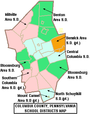
Public school districts
- Benton Area School District
- Berwick Area School District (also in Luzerne County)
- Bloomsburg Area School District
- Central Columbia School District
- Millville Area School District
- Mount Carmel Area School District (also in Northumberland County)
- North Schuylkill School District (also in Schuylkill County)
- Southern Columbia Area School District (also in Northumberland County)
Technical school
Charter school
- SusQ Cyber Charter School - Bloomsburg
Private schools
- Bald Hill School - Millville
- Bloomsburg Christian School - Bloomsburg
- Bloomsburg University Special Education Institute
- Columbia Co Christian School - Bloomsburg
- Greenwood Friends School - Millville
- Heritage Christian Academy - Berwick
- Holy Family Consolidate - Berwick
- Keystone National High School - Bloomsburg
- New Story - Berwick
- Pennsylvania Institute For Conservation Education - Bloomsburg
- Rainbow Hill School - Benton
- St Columba School - Bloomsburg
- Saint Matthews - Bloomsburg
- Turkey Ridge School - Bloomsburg
Libraries
- Bloomsburg Public Library
- Columbia County Traveling Library
- McBride Memorial Library
- Orangeville Public Library
Communities

Under Pennsylvania law, there are four types of incorporated municipalities: cities, boroughs, townships, and, in at most two cases, towns. The following town, boroughs and townships are located in Columbia County:
Town
- Bloomsburg (county seat)
Boroughs
Townships
Census-designated places
Census-designated places are geographical areas designated by the U.S. Census Bureau for the purposes of compiling demographic data. They are not actual jurisdictions under Pennsylvania law. Other unincorporated communities, such as villages, may be listed here as well.
Unincorporated communities
- Central
- Elk Grove
- Mifflin Cross Roads
Population ranking
The population ranking of the following table is based on the 2010 census of Columbia County.[16]
† county seat
| Rank | City/Town/etc. | Municipal type | Population (2010 Census) |
|---|---|---|---|
| 1 | † Bloomsburg | Town | 14,855 |
| 2 | Berwick | Borough | 10,477 |
| 3 | Ashland (mostly in Schuylkill County) | Borough | 2,817 |
| 4 | Espy | CDP | 1,642 |
| 5 | Catawissa | Borough | 1,552 |
| 6 | Mifflinville | CDP | 1,253 |
| 7 | Lightstreet | CDP | 1,093 |
| 8 | Almedia | CDP | 1,078 |
| 9 | Millville | Borough | 948 |
| 10 | Lime Ridge | CDP | 890 |
| 11 | Benton | Borough | 824 |
| 12 | Briar Creek | Borough | 660 |
| 13 | Fernville | CDP | 556 |
| 14 | Orangeville | Borough | 508 |
| 15 | Buckhorn | CDP | 318 |
| 16 | Aristes | CDP | 311 |
| 17 | Foundryville | CDP | 256 |
| 18 | Numidia | CDP | 244 |
| 19 | Stillwater | Borough | 209 |
| 20 | Wilburton Number One | CDP | 196 |
| 21 | Jerseytown | CDP | 184 |
| 22 | Rupert | CDP | 183 |
| 23 | Locustdale (partially in Schuylkill County) | CDP | 177 |
| 24 | Slabtown | CDP | 156 |
| 25 | Rohrsburg | CDP | 145 |
| 26 | Iola | CDP | 144 |
| 27 | Jamison City | CDP | 134 |
| 28 | Mainville | CDP | 132 |
| 29 | Eyers Grove | CDP | 105 |
| 30 | Wilburton Number Two | CDP | 96 |
| 31 | Jonestown | CDP | 64 |
| 32 | Waller | CDP | 48 |
| 33 | Centralia | Borough | 10 |
References
| Wikimedia Commons has media related to Columbia County, Pennsylvania. |
- "PHMC Historical Markers Search" (Searchable database). Pennsylvania Historical and Museum Commission. Commonwealth of Pennsylvania. Retrieved January 25, 2014.
- "State & County QuickFacts". United States Census Bureau. Retrieved November 16, 2013.
- "Find a County". National Association of Counties. Archived from the original on May 31, 2011. Retrieved June 7, 2010.
- "2010 Census Gazetteer Files". United States Census Bureau. August 22, 2012. Retrieved March 6, 2015.
- maps.google.com
- Topographic Map Summit Features in Columbia County, Pennsylvania, archived from the original on July 6, 2013, retrieved June 26, 2014
- Topographic Map Ridge Features in Columbia County, Pennsylvania, archived from the original on July 7, 2013, retrieved December 14, 2014
- "Google Maps". Google Maps. Retrieved 22 November 2018.
- "Population and Housing Unit Estimates". Retrieved October 16, 2018.
- "U.S. Decennial Census". United States Census Bureau. Retrieved March 6, 2015.
- "Historical Census Browser". University of Virginia Library. Retrieved March 6, 2015.
- Forstall, Richard L., ed. (March 24, 1995). "Population of Counties by Decennial Census: 1900 to 1990". United States Census Bureau. Retrieved March 6, 2015.
- "Census 2000 PHC-T-4. Ranking Tables for Counties: 1990 and 2000" (PDF). United States Census Bureau. April 2, 2001. Retrieved March 6, 2015.
- "U.S. Census website". United States Census Bureau. Retrieved January 31, 2008.
- "Office of Management and Budget - The White House". Retrieved 22 November 2018.
- "2010 U.S. Census website". United States Census Bureau. Retrieved December 29, 2015.
- Leip, David. "Dave Leip's Atlas of U.S. Presidential Elections". uselectionatlas.org. Retrieved 22 November 2018.
- "Voter registration statistics archives". Pennsylvania Department of State. November 8, 2011. Retrieved March 12, 2012.
Municipalities and communities of Columbia County, Pennsylvania, United States | ||
|---|---|---|
| Town | | |
| Boroughs | ||
| Townships | ||
| CDPs | ||
| Unincorporated communities | ||
| Ghost Towns | ||
| Footnotes | ‡This populated place also has portions in an adjacent county or counties | |

| Authority control |
|
|---|