Bradford County, Pennsylvania
Bradford County is a county located in the Commonwealth of Pennsylvania. As of the 2010 census, the population was 62,622.[2] Its county seat is Towanda.[3] It is bounded by these Pennsylvania counties: east by Susquehanna, southeast by Wyoming, south by Sullivan, southwest by Lycoming, and west by Tioga. To the north in the State of New York, it is bounded by the counties of Steuben to the northwest, Chemung to the north, and Tioga to the northeast. The county was created on February 21, 1810, from parts of Lycoming and Luzerne counties. Originally called Ontario County, it was reorganized and separated from Lycoming County on October 13, 1812, and renamed Bradford County for William Bradford, who had been a chief justice of the Pennsylvania Supreme Court and United States Attorney General.[4][5]
Bradford County | |
|---|---|
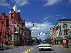 Towanda is the county seat | |
 Seal | |
 Location within the U.S. state of Pennsylvania | |
 Pennsylvania's location within the U.S. | |
| Coordinates: 41°47′N 76°31′W | |
| Country | |
| State | |
| Founded | February 21, 1810 |
| Named for | William Bradford |
| Seat | Towanda |
| Largest borough | Sayre |
| Area | |
| • Total | 1,161 sq mi (3,010 km2) |
| • Land | 1,147 sq mi (2,970 km2) |
| • Water | 14 sq mi (40 km2) 1.2%% |
| Population | |
| • Estimate (2018) | 60,833 |
| • Density | 53/sq mi (20/km2) |
| Congressional district | 12th |
| Website | www |
| Designated | July 10, 1982[1] |
Bradford County comprises the Sayre, PA Micropolitan Statistical Area.
The county is not to be confused with the city of Bradford, which is in McKean County, 141 miles to the west via U.S. Route 6.
History
As noted above, Bradford County was originally named Ontario County. The county was reorganized and renamed in 1812. However, a section of north Philadelphia in which major east–west streets are named after Pennsylvania counties retains an Ontario Street, between Westmoreland and Tioga Streets. There are two short Bradford Streets in northeast Philadelphia, approximately four miles from Ontario Street.
Geography
According to the U.S. Census Bureau, the county has a total area of 1,161 square miles (3,010 km2), of which 1,147 square miles (2,970 km2) is land and 14 square miles (36 km2) (1.2%) is water.[6] It is the second-largest county in Pennsylvania by land area and third-largest by total area.
Bradford has a warm-summer humid continental climate (Dfb) and average monthly temperatures in Towanda range from 24.5 °F in January to 70.6 °F in July.
Adjacent counties
- Chemung County, New York (north)
- Tioga County, New York (north)
- Susquehanna County (east)
- Wyoming County (southeast)
- Sullivan County (south)
- Lycoming County (southwest)
- Tioga County (west)
Demographics
| Historical population | |||
|---|---|---|---|
| Census | Pop. | %± | |
| 1820 | 11,554 | — | |
| 1830 | 19,746 | 70.9% | |
| 1840 | 32,769 | 66.0% | |
| 1850 | 42,831 | 30.7% | |
| 1860 | 48,734 | 13.8% | |
| 1870 | 53,204 | 9.2% | |
| 1880 | 58,541 | 10.0% | |
| 1890 | 59,233 | 1.2% | |
| 1900 | 59,403 | 0.3% | |
| 1910 | 54,526 | −8.2% | |
| 1920 | 53,166 | −2.5% | |
| 1930 | 49,039 | −7.8% | |
| 1940 | 50,615 | 3.2% | |
| 1950 | 51,722 | 2.2% | |
| 1960 | 54,925 | 6.2% | |
| 1970 | 57,962 | 5.5% | |
| 1980 | 62,919 | 8.6% | |
| 1990 | 60,967 | −3.1% | |
| 2000 | 62,761 | 2.9% | |
| 2010 | 62,622 | −0.2% | |
| Est. 2018 | 60,833 | [7] | −2.9% |
| U.S. Decennial Census[8] 1790–1960[9] 1900–1990[10] 1990–2000[11] 2010–2017[2] | |||
As of the census[12] of 2000, there were 62,761 people, 24,453 households, and 17,312 families residing in the county. The population density was 54 people per square mile (21/km²). There were 28,664 housing units at an average density of 25 per square mile (10/km²). The racial makeup of the county was 97.94% White, 0.40% Black or African American, 0.31% Native American, 0.45% Asian, 0.01% Pacific Islander, 0.19% from other races, and 0.69% from two or more races. 0.63% of the population were Hispanic or Latino of any race. 32.4% were of English, 19% German, 12.6% Irish and 6.4% Italian ancestry.
There were 24,453 households out of which 31.80% had children under the age of 18 living with them, 57.40% were married couples living together, 8.90% had a female householder with no husband present, and 29.20% were non-families. 24.70% of all households were made up of individuals and 11.50% had someone living alone who was 65 years of age or older. The average household size was 2.52 and the average family size was 2.99.
In the county, the population was spread out with 25.50% under the age of 18, 6.80% from 18 to 24, 27.20% from 25 to 44, 24.70% from 45 to 64, and 15.70% who were 65 years of age or older. The median age was 39 years. For every 100 females there were 95.10 males. For every 100 females age 18 and over, there were 92.10 males.
- Birth rate
The Bradford County live birth rate was 901 births in 1990.[13] The County's live birth rate in 2000 was 710 births,[14] while in 2011 it was 740 babies.[15] From 1960 to 2010, rural Pennsylvania has experienced a decline in the number of residents under 18 years old.[16]
- Teen pregnancy rate
Bradford County had a 511 babies born to teens (age 15–19) in 2011. In 2015, the number of teen births in Bradford County declined to 490.[17]
- County poverty demographics
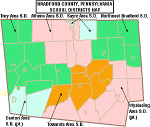
According to research by The Center for Rural Pennsylvania, which is a legislative agency of the Pennsylvania General Assembly, the poverty rate for Bradford County was 12.9% in 2014.[18] The statewide poverty rate was 13.6% in 2014. The 2012 childhood poverty rate by school district was: Athens Area School District – 40.3% living at 185% or below than the Federal Poverty Level; Canton Area School District – 45.4%; Northeast Bradford School District – 41.2%; Sayre Area School District – 42.7%; Troy Area School District – 39.9%; Towanda Area School District – 44.7% and Wyalusing Area School District – 35.7%.[19] The child poverty rate is collected by the school districts as part of the federal free school lunch program.
Micropolitan Statistical Area
The United States Office of Management and Budget[20] has designated Bradford County as the Sayre, PA Micropolitan Statistical Area (µSA).[21] As of the 2010 U.S. Census[22] the micropolitan area ranked 8th most populous in the State of Pennsylvania and the 131st most populous in the United States with a population of 62,622.
Law and government
Bradford County is a Republican Party stronghold in presidential elections. The only two instances Republican presidential candidates have failed to win the county from 1888 to the present were when Theodore Roosevelt won it in 1912 by splitting the Republican vote & in 1964 when Lyndon B. Johnson won statewide & nationally in a landslide. Johnson is also the only Democrat to ever manage over forty percent of the county's vote.
| Year | Republican | Democratic | Third parties |
|---|---|---|---|
| 2016 | 69.8% 18,141 | 24.5% 6,369 | 5.7% 1,476 |
| 2012 | 61.2% 14,410 | 36.6% 8,624 | 2.2% 506 |
| 2008 | 58.2% 15,057 | 39.8% 10,306 | 2.0% 526 |
| 2004 | 66.1% 16,942 | 33.5% 8,590 | 0.5% 120 |
| 2000 | 62.8% 14,660 | 33.9% 7,911 | 3.4% 781 |
| 1996 | 49.5% 10,393 | 36.8% 7,736 | 13.7% 2,879 |
| 1992 | 45.2% 10,221 | 30.5% 6,903 | 24.3% 5,504 |
| 1988 | 66.7% 13,568 | 32.6% 6,635 | 0.7% 134 |
| 1984 | 72.7% 14,808 | 26.9% 5,474 | 0.4% 85 |
| 1980 | 63.0% 13,139 | 30.9% 6,439 | 6.2% 1,287 |
| 1976 | 61.1% 12,851 | 37.6% 7,913 | 1.3% 270 |
| 1972 | 73.6% 15,050 | 25.4% 5,204 | 1.0% 204 |
| 1968 | 63.2% 13,308 | 30.3% 6,373 | 6.5% 1,377 |
| 1964 | 49.3% 10,434 | 50.6% 10,714 | 0.1% 14 |
| 1960 | 70.0% 16,252 | 29.8% 6,920 | 0.1% 33 |
| 1956 | 73.6% 15,399 | 26.3% 5,502 | 0.1% 30 |
| 1952 | 76.0% 15,894 | 23.7% 4,959 | 0.3% 55 |
| 1948 | 72.0% 11,783 | 27.0% 4,421 | 1.0% 163 |
| 1944 | 70.4% 13,472 | 28.9% 5,523 | 0.7% 142 |
| 1940 | 69.0% 14,826 | 30.7% 6,605 | 0.3% 53 |
| 1936 | 66.7% 16,643 | 32.4% 8,078 | 0.9% 215 |
| 1932 | 63.3% 11,521 | 32.8% 5,970 | 3.8% 697 |
| 1928 | 79.8% 17,251 | 19.8% 4,281 | 0.4% 77 |
| 1924 | 73.6% 11,620 | 14.6% 2,307 | 11.8% 1,857 |
| 1920 | 75.1% 11,947 | 17.8% 2,825 | 7.1% 1,128 |
| 1916 | 57.5% 6,178 | 34.0% 3,655 | 8.5% 909 |
| 1912 | 18.6% 2,034 | 27.0% 2,960 | 54.4% 5,963 |
| 1908 | 63.4% 7,997 | 29.8% 3,758 | 6.8% 853 |
| 1904 | 69.2% 8,303 | 23.9% 2,862 | 6.9% 828 |
| 1900 | 64.1% 8,625 | 31.3% 4,211 | 4.7% 631 |
| 1896 | 66.0% 9,422 | 30.8% 4,388 | 3.2% 457 |
| 1892 | 63.1% 8,132 | 31.7% 4,080 | 5.3% 676 |
| 1888 | 63.0% 8,762 | 32.7% 4,552 | 4.3% 594 |
County commissioners
- Daryl Miller, Chairman, Republican
- Doug McLinko, Vice-Chairman, Republican
- Edward Bustin, Democrat
Other county officials
- Auditors, Jeff Warner, Eric Matthews, Sebrina Shanks
- Clerk of Courts and Prothonotary, Dawn Close, Republican
- Coroner, Thomas Carman, Republican
- District Attorney, Chad Salsman, Republican
- Register of Wills and Recorder of Deeds, Sheila Johnson, Republican
- Sheriff, Clinton J. Walters, Republican
- Treasurer, Matthew Allen, Republican
State Senate
- Gene Yaw, Republican, Pennsylvania's 23rd Senatorial District
State House of Representatives
- Clint Owlett, Republican, Pennsylvania's 68th Representative District
- Tina Pickett, Republican, Pennsylvania's 110th Representative District
United States House of Representatives
United States Senate
- Pat Toomey, Republican
- Bob Casey, Democrat
Economy
Major employers are the natural gas industry, DuPont, Global-Tungsten and Powders (former Sylvania), Jeld-Wen, and Cargill Regional Beef, Wyalusing.
Education
Public school districts
- Athens Area School District
- Canton Area School District (also in Lycoming and Tioga Counties)
- Northeast Bradford School District
- Sayre Area School District
- Towanda Area School District
- Troy Area School District
- Wyalusing Area School District (also in Wyoming County)
- There are 14 public cyber charter schools in Pennsylvania that are available for free statewide, to children K-12. See: Education in Pennsylvania.
Other public school entities
- BLAST Intermediate Unit 17
- Northern Tier Career Center Towanda
- Adult Ed Linkage Services – Troy
- Lackawanna College Towanda Center[24]
Private schools
- Canton Country School – Canton
- Children's Place – Sayre
- Epiphany School (Catholic) Pre-K–6 – Sayre accepting OSTCP students
- Freedom Lane Academy – Milan
- G&G Learning Center – Rome
- Maranatha Mission Learning Community Branch 19 – Canton
- North Rome Christian School
- South Hill Amish School – Wyalusing
- St. Agnes Elementary School – Towanda accepting OSTCP students
- Union Valley Christian School – Ulster
- Valley View Amish School – Pike Township
- Wyalusing Valley Children's Center INC – Wyalusing
Data from EdNA database maintained by Pennsylvania Department of Education 2012
Libraries
- Allen F. Pierce Free Library – Troy
- Bradford County Library – Troy
- Bradford County Library System – Troy
- Green Free Library – Canton
- Mather Memorial Library – Ulster
- Monroeton Public Library – Monroeton
- New Albany Community Library Inc.
- Sayre Public Library
- Spalding Memorial Library – Athens
- Towanda Public Library
- Wyalusing Public Library
Transportation
Public transportation is provided by BeST Transit.
Communities

Under Pennsylvania law, there are four types of incorporated municipalities: cities, boroughs, townships, and, in only one case (Bloomsburg, Columbia County), towns. The following boroughs and townships are located in Bradford County:
Boroughs
- Alba
- Athens
- Burlington
- Canton
- Le Raysville
- Monroe
- New Albany
- Rome
- Sayre
- South Waverly
- Sylvania
- Towanda (county seat)
- Troy
- Wyalusing
Townships
- Albany
- Armenia
- Asylum
- Athens
- Burlington
- Canton
- Columbia
- Franklin
- Granville
- Herrick
- Leroy
- Litchfield
- Monroe
- North Towanda
- Orwell
- Overton
- Pike
- Ridgebury
- Rome
- Sheshequin
- Smithfield
- South Creek
- Springfield
- Standing Stone
- Stevens
- Terry
- Towanda
- Troy
- Tuscarora
- Ulster
- Warren
- Wells
- West Burlington
- Wilmot
- Windham
- Wyalusing
- Wysox
Census-designated place
Population ranking
The population ranking of the following table is based on the 2010 census of Bradford County.[22]
† county seat
| Rank | City/Town/etc. | Population (2010 Census) | Municipal type | Incorporated |
|---|---|---|---|---|
| 1 | Sayre | 5,587 | Borough | 1891 |
| 2 | Athens | 3,367 | Borough | 1831 |
| 3 | † Towanda | 2,919 | Borough | 1828 |
| 4 | Canton | 1,976 | Borough | 1864 |
| 5 | Troy | 1,354 | Borough | |
| 6 | South Waverly | 1,027 | Borough | 1878 |
| 7 | Greens Landing | 894 | CDP | |
| 8 | Wyalusing | 596 | Borough | |
| 9 | Monroe | 554 | Borough | 1855 |
| 10 | Rome | 441 | Borough | 1860 |
| 11 | New Albany | 356 | Borough | 1879 |
| 12 | Le Raysville | 290 | Borough | 1863 |
| 13 | Sylvania | 219 | Borough | 1853 |
| 14 | Alba | 157 | Borough | 1864 |
| 15 | Burlington | 156 | Borough | 1854 |
References
- "PHMC Historical Markers Search" (Searchable database). Pennsylvania Historical and Museum Commission. Commonwealth of Pennsylvania. Retrieved January 25, 2014.
- "State & County QuickFacts". United States Census Bureau. Archived from the original on February 19, 2016. Retrieved November 16, 2013.
- "Find a County". National Association of Counties. Archived from the original on May 31, 2011. Retrieved June 7, 2011.
- An outline history of Tioga and Bradford counties in Pennsylvania, Chemung, Steuben, Tioga, Tompkins and Schuyler in New York: by townships, villages, boro's and cities, John L. Sexton. The Gazette Company, 1885, p67. 1885. p. 67. Retrieved September 17, 2010.
bradford county, pa. sexton.
- Bradford County History Archived July 27, 2011, at the Wayback Machine, Bradford County, Pennsylvania. Accessed August 21, 2007
- "2010 Census Gazetteer Files". United States Census Bureau. August 22, 2012. Retrieved March 5, 2015.
- "Population and Housing Unit Estimates". Retrieved October 16, 2018.
- "U.S. Decennial Census". United States Census Bureau. Retrieved March 5, 2015.
- "Historical Census Browser". University of Virginia Library. Retrieved March 5, 2015.
- Forstall, Richard L., ed. (March 24, 1995). "Population of Counties by Decennial Census: 1900 to 1990". United States Census Bureau. Retrieved March 5, 2015.
- "Census 2000 PHC-T-4. Ranking Tables for Counties: 1990 and 2000" (PDF). United States Census Bureau. April 2, 2001. Retrieved March 5, 2015.
- "U.S. Census website". United States Census Bureau. Retrieved January 31, 2008.
- Pennsylvania Department of Health, Birth Age County Reports 1990, 1990
- Pennsylvania Department of Health, Birth Age County Reports 2000, 2000
- Pennsylvania Department of Health, Birth Age County Reports 2011, 2011
- Center for Rural Pennsylvania, Number of Children Decreasing in Rural Pennsylvania, 2011
- Robert Wood Johnson Foundation (2016). "Pennsylvania Teen Births".
- US Census Bureau (2015). "Poverty Rates by County Small Area Income and Poverty Estimates".
- Pennsylvania Budget and Policy Center (2012). "Student Poverty Concentration 2012". Archived from the original on 2015-12-22. Retrieved 2018-12-09.
- "Office of Management and Budget - The White House". Retrieved 21 November 2018.
- "Archived copy". Archived from the original on 2015-09-24. Retrieved 2017-12-07.CS1 maint: archived copy as title (link)
- "2010 U.S. Census website". United States Census Bureau. Retrieved 2015-05-25.
- Leip, David. "Dave Leip's Atlas of U.S. Presidential Elections". uselectionatlas.org. Retrieved 21 November 2018.
- "Towanda - Lackawanna College". www.lackawanna.edu. Retrieved 21 November 2018.
External links
- Bradford County official website
- Bradford County Historical Society
- Bradford County Tourist and Visitor Guide
- Pennsylvania Department of Transportation, Bureau of Planning and Research, Geographic Information Division, "2005 General Highway Map of Bradford County". Note: shows boroughs, townships, roads, villages, some streams. URL accessed on April 6, 2006.
| Wikimedia Commons has media related to Bradford County, Pennsylvania. |
Places adjacent to Bradford County, Pennsylvania | ||||||||||
|---|---|---|---|---|---|---|---|---|---|---|
| ||||||||||
Municipalities and communities of Bradford County, Pennsylvania, United States | ||
|---|---|---|
| Boroughs | | |
| Townships |
| |
| CDP | ||
| Unincorporated communities | ||

| Authority control |
|
|---|