West Hazleton, Pennsylvania
West Hazleton is a borough in Luzerne County, Pennsylvania, 31 miles (50 km) south of Wilkes Barre. The population was 4,594 as of the 2010 census.
West Hazleton, Pennsylvania | |
|---|---|
Borough | |
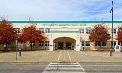 West Hazleton Elementary/Middle School | |
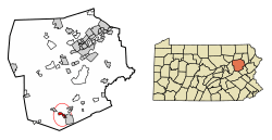 Location of West Hazleton in Luzerne County, Pennsylvania. | |
 West Hazleton Location of West Hazleton in Luzerne County, Pennsylvania.  West Hazleton West Hazleton (the United States) | |
| Coordinates: 40°57′42″N 75°59′56″W | |
| Country | United States |
| State | Pennsylvania |
| County | Luzerne |
| Incorporated | 1887 |
| Government | |
| • Type | Borough Council |
| • Mayor | John Chura |
| Area | |
| • Total | 1.50 sq mi (3.88 km2) |
| • Land | 1.50 sq mi (3.88 km2) |
| • Water | 0.00 sq mi (0.00 km2) |
| Population (2010) | |
| • Total | 4,594 |
| • Estimate (2018)[2] | 4,477 |
| • Density | 2,989.99/sq mi (1,154.58/km2) |
| Time zone | UTC-5 (Eastern (EST)) |
| • Summer (DST) | UTC-4 (EDT) |
| Area code(s) | 570 |
| FIPS code | 42-83136 |
| Website | West Hazleton Borough |
History
The community of West Hazleton was founded by Conrad Horn. The borough was officially established on March 12, 1887. West Hazleton gained prominence in the 19th and 20th centuries as an active anthracite coal mining community; it attracted thousands of European immigrants. The first burgess was J.W. McMurtrie; he served from 1888 to 1890. West Hazleton was once home to Hazle Park, a popular attraction in the area. The legendary Babe Ruth played at the nearby Cranberry Ballpark.[3]
.jpg) Children's Home, West Hazleton
Children's Home, West Hazleton.jpg) The Miners Bank and War Memorial, West Hazleton
The Miners Bank and War Memorial, West Hazleton
Geography

West Hazleton is located at 40°57′42″N 75°59′56″W (40.961651, -75.998915).[4] According to the United States Census Bureau, the borough has a total area of 1.5 square miles (3.9 km2), all of it land.
West Hazleton is a small strip of land west of Hazleton City; it is mostly concentrated around Pennsylvania Route 93. Interstate 81 runs through the northern section of the borough. West Hazleton is mostly residential; it also consists of two shopping centers, an industrial park, a movie theater, and a youth sports complex.[3]
Education
West Hazleton is part of Hazleton Area School District. West Hazleton Elementary/Middle School is located within the borough.[5]
Demographics
| Historical population | |||
|---|---|---|---|
| Census | Pop. | %± | |
| 1880 | 191 | — | |
| 1890 | 931 | 387.4% | |
| 1900 | 2,516 | 170.2% | |
| 1910 | 4,715 | 87.4% | |
| 1920 | 5,854 | 24.2% | |
| 1930 | 7,310 | 24.9% | |
| 1940 | 7,523 | 2.9% | |
| 1950 | 6,988 | −7.1% | |
| 1960 | 6,278 | −10.2% | |
| 1970 | 6,059 | −3.5% | |
| 1980 | 4,871 | −19.6% | |
| 1990 | 4,136 | −15.1% | |
| 2000 | 3,542 | −14.4% | |
| 2010 | 4,594 | 29.7% | |
| Est. 2018 | 4,477 | [2] | −2.5% |
| Sources:[6][7][8] | |||
As of the 2010 census, West Hazleton was 71.9% White, 3.1% Black or African American, 0.4% Native American, 0.3% Asian, 0.1% Native Hawaiian, and 3.4% were two or more races. 35.4% of the population were of Hispanic or Latino ancestry, up from just 2.2% in 2000.[9]
At the 2000 census there were 3,542 people, 1,634 households, and 915 families residing in the borough. The population density was 2,281.0 people per square mile (882.3/km2). There were 1,834 housing units at an average density of 1,181.1 per square mile (456.8/km2). The racial makeup of the borough was 97.71% White, 0.56% African American, 0.06% Native American, 0.23% Asian, 1.02% from other races, and 0.42% from two or more races. Hispanic or Latino of any race were 2.23%.[7]
There were 1,634 households, 21.6% had children under the age of 18 living with them, 38.9% were married couples living together, 12.0% had a female householder with no husband present, and 44.0% were non-families. 39.2% of households were made up of individuals, and 18.6% were one person aged 65 or older. The average household size was 2.13 and the average family size was 2.86.
In the borough the population was spread out, with 20.3% under the age of 18, 6.7% from 18 to 24, 27.4% from 25 to 44, 22.4% from 45 to 64, and 23.1% 65 or older. The median age was 42 years. For every 100 females there were 92.8 males. For every 100 females age 18 and over, there were 88.1 males.
The median household income was $28,765 and the median family income was $37,476. Males had a median income of $30,139 versus $18,400 for females. The per capita income for the borough was $16,525. About 7.3% of families and 10.0% of the population were below the poverty line, including 13.8% of those under age 18 and 11.1% of those age 65 or over.
References
- "2017 U.S. Gazetteer Files". United States Census Bureau. Retrieved Mar 24, 2019.
- "Population and Housing Unit Estimates". Retrieved October 1, 2019.
- http://www.westhazletonboro.org/Pages/Home.aspx
- "US Gazetteer files: 2010, 2000, and 1990". United States Census Bureau. 2011-02-12. Retrieved 2011-04-23.
- "Locate Us." Hazleton Area School District. Retrieved on July 18, 2016.
- "Census of Population and Housing". U.S. Census Bureau. Retrieved 11 December 2013.
- "U.S. Census website". United States Census Bureau. Retrieved 2008-01-31.
- "Incorporated Places and Minor Civil Divisions Datasets: Subcounty Resident Population Estimates: April 1, 2010 to July 1, 2012". Population Estimates. U.S. Census Bureau. Archived from the original on 11 June 2013. Retrieved 11 December 2013.
- "Census 2010: Pennsylvania".
External links
Municipalities and communities of Luzerne County, Pennsylvania, United States | ||
|---|---|---|
| Cities |  | |
| Boroughs |
| |
| Townships | ||
| CDPs | ||
| Unincorporated communities |
| |
| Footnotes | ‡This populated place also has portions in an adjacent county or counties | |
| Authority control |
|
|---|