South Fork Republican River
The South Fork Republican River is a river that arises in Lincoln County, Colorado, United States, and flows east-northeastward for about 171 miles (275 km)[3] through Kit Carson and Yuma Counties, Colorado, and Cheyenne County, Kansas, to a confluence with the Republican River in Dundy County, Nebraska. Bonny Reservoir is located on the South Fork Republican River in Yuma County, Colorado.
| South Fork Republican River | |
|---|---|
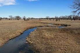 The river in Hale, Colorado. | |
| Location | |
| Country | United States |
| State | Colorado, Kansas, Nebraska |
| Physical characteristics | |
| Source | |
| ⁃ location | Lincoln County, Colorado |
| ⁃ coordinates | 39°12′53″N 103°20′14″W |
| ⁃ elevation | 5,384 ft (1,641 m) |
| Mouth | Republican River |
⁃ location | Benkelman, Nebraska |
⁃ coordinates | 40°02′30″N 101°31′17″W[1] |
⁃ elevation | 2,969 ft (905 m) |
| Length | 171 mi (275 km) |
| Basin size | 2,778 sq mi (7,190 km2) |
| Discharge | |
| ⁃ location | USGS 06827500 near Benkelman, NE[2] |
| ⁃ average | 35.1 cu ft/s (0.99 m3/s) |
| ⁃ minimum | 0 cu ft/s (0 m3/s) |
| ⁃ maximum | 6,220 cu ft/s (176 m3/s) |
| Basin features | |
| Watersheds | South Fork Republican- Republican-Kansas-Missouri- Mississippi |
The South Fork Republican River drains an area of 2,778 square miles (7,190 km2), including 2,106 square miles (5,450 km2), or 75.8%, in eastern Colorado, 667 square miles (1,730 km2), or 24.0%, in northwestern Kansas, and 6 square miles (16 km2), or 0.2%, in southwestern Nebraska.[4]
Use of water from the South Fork Republican River is governed by the Republican River Compact, a water agreement among the U.S. states of Colorado, Kansas, and Nebraska signed on 12-31-1942
See also
- List of rivers in Colorado
- List of rivers in Kansas
- List of rivers in Nebraska
- Colorado drainage basins
References
- "South Fork Republican River". Geographic Names Information System. United States Geological Survey. Retrieved 2015-12-04.
- "Water-Data Report 2013 - 06827500 South Fork Republican River near Benkelman, NE" (PDF). U.S. Geological Survey. Retrieved 2015-12-04.
- U.S. Geological Survey. National Hydrography Dataset high-resolution flowline data. The National Map, accessed March 29, 2011
- Gustafson, Daniel L. (2003-01-24). "Hydrologic Unit Project". Montana State University, Environmental Statistics Group. Retrieved 2008-02-05.
External links

Lincoln (capital) | ||
| Topics | ||
| Society |
| |
| Regions | ||
| Largest cities | ||
| Counties |
| |