Lake Rakshastal
Lake Rakshastal (Tibetan: ལག་ངར་མཚོ ; Chinese: 拉昂错) is a lake in Tibet Autonomous Region, China, lying just west of Lake Manasarovar and south of Mount Kailash.[1] The Sutlej River (also known by the Tibetan name Langqen Zangbo in this area) originates at Rakshastal's northwestern tip. Despite its close proximity to Lake Manasarovar (about 3.7 kilometres or 2.3 miles), Lake Rakshastal does not share the historic religious significance of its eastern neighbor.
| Lake Rakshastal | |
|---|---|
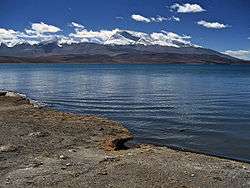 View South from Rakshas Tal Lake (2006) | |
| Location | Tibet Autonomous Region, China |
| Coordinates | 30.65°N 81.25°E |
| Lagngar Co | |||||||
|---|---|---|---|---|---|---|---|
| Chinese name | |||||||
| Traditional Chinese | 拉昂錯 | ||||||
| Simplified Chinese | 拉昂错 | ||||||
| |||||||
| Alternative Chinese name | |||||||
| Traditional Chinese | 蘭嘎錯 | ||||||
| Simplified Chinese | 兰嘎错 | ||||||
| |||||||
| Tibetan name | |||||||
| Tibetan | ལག་ངར་མཚོ | ||||||
| |||||||
Etymology
The name of the lake literally means "lake of the demon" in Sanskrit. It is also known as Ravan Tal, as it is considered to be the place of severe penance by Ravan, the demon-like egoistic King of Lanka in Hindu theology.[2]
In Buddhism, Lake Manasarovar, which is round like the sun, and Rakshastal, shaped as a crescent, are respectively regarded as "brightness" and "darkness". Both are freshwater lakes. There is a short river named Ganga Chhu, which connects Lake Manasarovar with Rakshastal, is created by rishis to add pure water from Manasarovar.
There are four islands in Rakshastal, named Topserma (Dose), Dola (the two biggest), Lachato (Nadzhado), and Dosharba.[3] The islands are used by local people as winter pastures for their yaks.
Mythology
According to Hindu scriptures, Rakshastal was created by Ravana for the express purpose of garnering superpowers through acts of devotion and meditation to the god, Shiva, who resided on Mount Kailash. It was upon the banks of a special island in this lake that he would make a daily offering with one of his ten heads as a sacrifice to please Shiva. Finally, on the tenth day, Shiva was moved enough by his devotion to grant Ravana his wish to obtain superpowers.
Geography
Rakshastal covers a total area of 250 square kilometres (97 sq mi), at an altitude of 4,575 metres (15,010 ft). Though absent of nearby grasslands, the white cobbles, the hills and the island colored with dark red, and the deep blue lake water present another distinctive picture absent from many of the places more frequented by visitors.
Climate
| Climate data for Lake Rakshastal | |||||||||||||
|---|---|---|---|---|---|---|---|---|---|---|---|---|---|
| Month | Jan | Feb | Mar | Apr | May | Jun | Jul | Aug | Sep | Oct | Nov | Dec | Year |
| Average high °C (°F) | −2.7 (27.1) |
−1.5 (29.3) |
1.3 (34.3) |
6.7 (44.1) |
10.5 (50.9) |
13.7 (56.7) |
13.6 (56.5) |
13.1 (55.6) |
11.1 (52.0) |
6.6 (43.9) |
1.5 (34.7) |
−0.8 (30.6) |
6.1 (43.0) |
| Daily mean °C (°F) | −8.2 (17.2) |
−6.9 (19.6) |
−3.7 (25.3) |
0.3 (32.5) |
3.5 (38.3) |
7.3 (45.1) |
8.5 (47.3) |
8.2 (46.8) |
5.6 (42.1) |
0.2 (32.4) |
−4.5 (23.9) |
−6.6 (20.1) |
0.3 (32.6) |
| Average low °C (°F) | −13.6 (7.5) |
−12.3 (9.9) |
−8.6 (16.5) |
−6.0 (21.2) |
−3.4 (25.9) |
1.0 (33.8) |
3.4 (38.1) |
3.3 (37.9) |
0.1 (32.2) |
−6.2 (20.8) |
−10.4 (13.3) |
−12.4 (9.7) |
−5.4 (22.2) |
| Average precipitation mm (inches) | 58 (2.3) |
39 (1.5) |
58 (2.3) |
34 (1.3) |
29 (1.1) |
46 (1.8) |
142 (5.6) |
152 (6.0) |
76 (3.0) |
32 (1.3) |
8 (0.3) |
20 (0.8) |
694 (27.3) |
| Source: Climate-Data.org | |||||||||||||
See also
- Lake Manasarovar
- Lakes of India
References
- Taruna Vijaya (2001). Kailash Manasarovar, an odyssey in Tibet. Ritwik Prakashan. p. 58. Retrieved 2012-07-24.
- Pradeep Chamaria (1996). Kailash Manasarovar on the Rugged Road to Revelation. Abhinav Publications. p. 67. ISBN 978-81-7017-336-6. Retrieved 2012-07-24.
- "Archived copy". Archived from the original on 2010-11-05. Retrieved 2010-10-11.CS1 maint: archived copy as title (link)