Rutog County
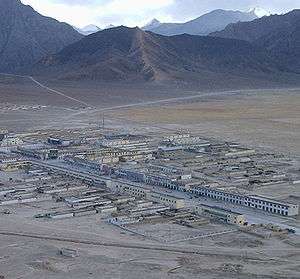
Rutog County (Tibetan: རུ་ཐོག་རྫོང་།, Wylie: ru thog rdzong, ZYPY: Rutog Zong )[4][5][3][6][7][8] is a county in Ngari Prefecture, Tibet Autonomous Region of the People's Republic of China. The county seat is Rutog, located some 1,140 km (710 mi) or 700 miles west- northwest of the Tibetan capital, Lhasa. Rutog County shares a border with India.[9]
Rutog County 日土县 • རུ་ཐོག་རྫོང་། Rudok | |
|---|---|
County | |
 | |
.png) Location of Rutog County (red) within Ngari Prefecture (yellow) and the Tibet Autonomous Region | |
 Rutog Location of the seat in the Tibet Autonomous Region | |
| Coordinates: 33°54′48″N 80°45′01″E | |
| Country | People's Republic of China |
| Region | Tibet Autonomous Region |
| Prefecture | Ngari Prefecture |
| County seat | Rutog |
| Township-level divisions | 1 town, 4 townships |
| Area | |
| • Total | 81,046 km2 (31,292 sq mi) |
| Elevation | 4,500 m (14,800 ft) |
| Population (2015)[1] | |
| • Total | 10,635 |
| • Density | 0.13/km2 (0.34/sq mi) |
| Ethnic groups | |
| • Major ethnic groups | Tibetan[2] |
| Time zone | UTC+8 (China Standard) |
| Postal code | 859700 |
| Website | rt |
The county has a rich history of folk tales, myths, legends, proverbs and folk songs and has many caves, rock paintings and other relics. The Xinjiang-Tibet Highway runs through the Rutog County for 340 km (210 mi). The county, established in March 1961 covers 74,500 km2 (28,800 sq mi) but has a very low population density with a population of just over 10,000.
Name
'Rutog' is Tibetan for 'at the foot of the mountain shaped like a firearm rack' (枪叉支架状山下).[2][10]
History


Although when the county was established in 1961, it was part of the Xinjiang Uygur Autonomous Region, in 1978 it became a part of the Tibet Autonomous Region, under the jurisdiction of the Ngari Prefecture.[2]
In October 1983, the county seat was moved from Rutog to Derukunzi (德汝昆孜).[2]
At around 11 AM on July 17, 2016, nine people, 350 sheep and 110 yaks were buried in an avalanche about 250 km (160 mi) from Rutog Town (at 34°02′45.4″N 82°17′24.6″E). The avalanche fell on a grazing area and the snow was as much as 8 m (26 ft) deep. The local government dispatched rescuers and equipment to the site of the avalanche.[3][11][12] The avalanche was described by NASA as one of the largest avalanches in history.[13][14] On September 21, 2016, another similarly large avalanche occurred just to the south.[15][16]
Geography and climate

Rutog County is located in northwestern Tibet, Ngari northwest with a number of territorial borders. It is divided into 12 townships and 30 village committees. The Karakoram Mountains go through the county. The average altitude of 4,500 m (14,800 ft) with a maximum altitude of 6,800 m (22,300 ft).
The Nu River flows through this county of mountain shrub grassland and alpine grassland soil. Lakes in Rutog County include Bangda Lake, Guozha Lake, Longmu Lake, Lumajangdong Co, Wo Erba Lake and Pangong Tso[17].
Rutog County is located in semi-arid plateau sub-frigid monsoon climate zone, climate with low air pressure, radiation strong, cold and dry with very little precipitation. Gang Tisi, also known as "Kala Si" mountain is the highest point of Rutog County at 6800 meters above sea level, and since ancient times, people in Central Asia have come to visit it on pilgrimage routes. The county has an annual sunshine duration of 3370.9 hours, annual precipitation is 73.4 mm (2.89 in), annual evaporation is 2,456.3 mm (96.70 in), and annual average wind speed 3.2 m/s (7.2 mph).
Overall Rutog County has a rough subarctic climate with long, very cold, sometimes snowy winters and short, cool, humid summers (Dfc) owing its extreme altitude.
To the north, Rutog County shares borders with Hotan County (Hetian), Qira County (Cele) and Keriya County (Yutian) in Hotan Prefecture (Hetian), Xinjiang. To the east, the county borders Gêrzê County.[16]
Demographics
| Historical population | ||
|---|---|---|
| Year | Pop. | ±% p.a. |
| 2000 | 7,175 | — |
| 2010 | 9,738 | +3.10% |
| [2] | ||
As of 1996, the residents of the county were Tibetan.[2]
Economy
Rutog County's economy is based around farming and animal husbandry. Aside from wool, butter, hides, cattle cashmere, etc. are produced. In Rutog County, the main growing crop is barley and yaks, sheep, goats, horses and other livestock are important to the economy. Rutog County has many wild animals and plants, including the black-necked crane, goose, wild yak, Tibetan antelope, Mongolian gazelle, black sheep, kiang, and bear. A number of rare animals are protected by the government and are of high value. Known mineral resources are gold, lead, chromite, borax, and salt.
In the five years from 2006–2011, Rutog County produced 72 tons of cashmere wool worth 16 million yuan ($2.5 million USD in 2011).[19] China produces 75% of the world's cashmere wool.[20]
In 1984, the average per capita income of Rutog County residents was 478 yuan.[21]
Infrastructure
In 1989 the Rutog County Commerce and Industry Bureau was established. In June 2002 it successfully held the first Bangong Folk Festival. As of the end of May 2006, the Rutog County Branch of the Agricultural Bank of China which was established in 1995, has given total loans amounting to 92.5 million yuan, mainly funding the distribution of animal products for farmers in Rutog County. The bank loaned 12.2 million yuan in 2006 alone.
In 1984, Rutog County television station was established and in 1985, Japanese investors built the first cinema on county soil. Japan also invested in Rutog's radio facilities.
Transportation
The China National Highway 219 passes through Rutog County.
Historical maps
Historical maps including Rutog:
 Map of the expeditions of Sven Hedin (1906-8) including Rutog (labeled as Rudok) (RGS, early 20th century)
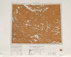 Map including Rutog (labeled as Rudok) (AMS, 1950)[lower-alpha 1]
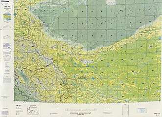 Map including the Rutog County area (DMA, 1980)
 Map including Rutog (Jih-t'u) (DMA, 1995)
See also
Notes
- From map: "THE DELINEATION OF INTERNATIONAL BOUNDARIES ON THIS MAP MUST NOT BE CONSIDERED AUTHORITATIVE."
References
- 地区经济司 (30 November 2017). 西藏自治区阿里地区日土县. National Development and Reform Commission (in Chinese). Archived from the original on 24 May 2020. Retrieved 24 May 2020 – via Internet Archive.
日土县隶属阿里地区,全县总面积81046平方公里,辖1镇4乡。2015年总人口10635人。
- 日土县历史沿革 [Rutog County Historical Development] (in Chinese). XZQH.org. 5 April 2016. Retrieved 21 May 2019.
1961年3月设立日土县,由新疆维吾尔自治区管辖,1978年划归西藏自治区,隶属阿里地区管辖至今。{...}1996年,日土县面积8.1万平方千米,人口约0.61万人,均为藏族。{...}2000年第五次人口普查,日土县常住总人口7175人,{...}2008年,全县面积7.70万多平方千米,人口0.87万人。2010年第六次人口普查,日土县常住总人口9738人,其中,日土镇3057人,热帮乡2242人,日松乡1921人,东汝乡1278人,多玛乡1240人。
- "Avalanche buries 9 in Tibet". China Internet Center. 18 July 2016. Retrieved 22 May 2020.
- Berman, Lex (2017-03-17). "Tibetan Administrative Placenames Cross Index (2001)". doi:10.7910/dvn/prcltu. Retrieved 2018-04-28.
- Ministry of Housing and Urban-Rural Development (2010). 建筑抗震设计规范 [GB50011-2010: Code for Seismic Design of Buildings] (in English and Chinese). Beijing: China Architecture & Building Press. p. 198 – via Google Books.
Rutog County
- Webster's 21st Century World Atlas. Barnes & Noble Books. 1999. p. 94 – via Internet Archive.
Rutog
- Complete Atlas Of The World (3 ed.). Penguin Random House. 2016. p. 238 – via Internet Archive.
Rutog
- Li Xia, ed. (6 August 2019). "Scenery of glacier in Rutog County, SW China's Tibet". Xinhua News Agency. Retrieved 21 May 2020.
Rutog County of Ngari Prefecture, southwest China's Tibet Autonomous Region.
- "China". Foreign Broadcast Information Service. 2 September 1988. p. 68. Retrieved 22 May 2020 – via Internet Archive.
- 阿里地区日土县概况. 阿里地区日土县人民政府 (in Chinese). 19 March 2015. Retrieved 22 May 2020.
日土县辖4乡1镇,包括日土镇、日松乡、热帮乡、多玛乡,东汝乡。
- "Tibet: Nine killed in an avalanche". The Indian Express. 18 July 2016. Retrieved 22 May 2020.
- "Nine Killed in Avalanche in Tibet". China Central Television. 18 July 2016. Retrieved 23 May 2020 – via YouTube.
- Ben Guarino (12 December 2016). "A Tibetan glacier mysteriously collapsed and killed 9. Now researchers offer answers". Washington Post. Retrieved 22 May 2020.
- "Massive and Mysterious Ice Avalanche in Tibet". NASA Earth Observatory. Retrieved 22 May 2020.
- "A Second Massive Ice Avalanche in Tibet". NASA Earth Observatory. Retrieved 26 May 2020.
- Shixin Wang, Baolin Yang, Yi Zhou, Futao Wang, Rui Zhang, Qing Zhao (2018). "SNOW COVER MAPPING AND ICE AVALANCHE MONITORING FROM THE SATELLITE DATA OF THE SENTINELS" (PDF). International Archives of Photogrammetry, Remote Sensing and Spatial Information Sciences. 42 (3): 1766. Retrieved 26 May 2020 – via Semantic Scholar.CS1 maint: uses authors parameter (link)
- Dreams of Snow Land. Beijing: Foreign Languages Press. 2005. pp. 273-275. ISBN 7-119-03883-4 – via Internet Archive.
- 2019年统计用区划代码和城乡划分代码:日土县 [2019 Statistical Area Numbers and Rural-Urban Area Numbers: Rutog County] (in Chinese). National Bureau of Statistics of the People's Republic of China. 2019. Retrieved 21 May 2019.
统计用区划代码 名称 542524100000 日土镇 542524200000 热帮乡 542524201000 日松乡 542524202000 东汝乡 542524203000 多玛乡
- http://www.chinadaily.com.cn/china/2011-06/27/content_12780292.htm
- http://www.chinadaily.com.cn/business/2011-10/13/content_13884938.htm
- "China Report POLITICAL, SOCIOLOGICAL AND MILITARY AFFAIRS". Foreign Broadcast Information Service. 29 October 1984. p. 24. Retrieved 22 May 2020 – via Internet Archive.
External links
- Hudong Encyclopedia (in Chinese)
| County-level divisions | 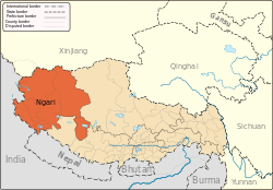 | |
|---|---|---|
| Towns and villages | ||
| Geography |
| |
| Landmarks | ||