Farrukhabad
Farrukhabad is a city in the Indian state of Uttar Pradesh. It is the administrative headquarters of the Farrukhabad tehsil. The city is on the banks of river Ganges and is 338 kilometres (210 mi) from the national capital Delhi and 190 kilometres (120 mi) from the state capital Lucknow.
Farrukhabad | |
|---|---|
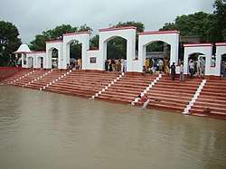 Panchal Ghat on the bank of river Ganges | |
 Farrukhabad Location in Uttar Pradesh  Farrukhabad Location in India  Farrukhabad Location in Asia | |
| Coordinates: 27.37°N 79.63°E | |
| Country | India |
| State | Uttar Pradesh |
| District | Farrukhabad |
| Founded | 1714 |
| Government | |
| • MP | Mukesh Rajput |
| • District Magistrate | Manvendra Singh |
| Population (2011)[1] | |
| • Total | 275,754 |
| Demonym(s) | Farrukhabadi |
| Language | |
| • Official | Hindi[2] |
| • Additional official | Urdu[2] |
| Time zone | UTC+5:30 (IST) |
| PIN | 209625 |
| Telephone code | 05692 |
| Vehicle registration | UP-76 |
| Nearest city | Bareilly (120KM) Kanpur (130 KM) Agra (180 KM) |
| Effective literacy | 73.4% |
| Lok Sabha constituency | Farrukhabad |
| Website | farrukhabad.nic.in |
Demographics
As of 2011 India census Farrukhabad had a population of 276,581 along with Fatehgarh, of which 145,641 were males and 130,940 were females. The population in the age group 0 to 6 years was 34,474. The total number of literates in the city 177,793, which constituted 64.2% of the total population, with 98,659 males and 79,134 females being literate. The effective literacy of 7+ population was 73.4% with male literacy of 77.6%, and female literacy is 68.8%. Sex ratio of Farrukhabad is 899 per 1000 male. The Scheduled Castes and Scheduled Tribes population was 32,769 and 43 respectively. Farrukhabad had 48850 households in 2011[1]
According to 2001 census, Farrukhabad-cum-Fatehgarh had a population of 227,876, of which 120,783 were males and 107,093 were females. Population between the age of 0 to 6 years was 30,120. The total number of literates were 143,736, which constituted 63% of the total population.[3]
Transportation
Railways
- Farrukhabad Junction railway station
- Fatehgarh railway station
- Yaqutganj railway station
- Harsinghpur Goba station
- Kaimganj railway station
- Kamalganj railway station
- Shamshabad railway station
| Jhansi Mainpuri Kanpur | |||||||||||||||||||||||||||||||||||||||||||||||||||||||||||||||||||||||||
|---|---|---|---|---|---|---|---|---|---|---|---|---|---|---|---|---|---|---|---|---|---|---|---|---|---|---|---|---|---|---|---|---|---|---|---|---|---|---|---|---|---|---|---|---|---|---|---|---|---|---|---|---|---|---|---|---|---|---|---|---|---|---|---|---|---|---|---|---|---|---|---|---|---|
| |||||||||||||||||||||||||||||||||||||||||||||||||||||||||||||||||||||||||
Roadways
Farrukhabad was a part of the Ganga Expressway, an ambitious project of Rs. 400 billion to provide high speed connectivity between the eastern and the western parts of the state.[4] The city has a bus station belonging to the Uttar Pradesh State Road Transport System.
Airways
Farrukhabad has an airstrip at Mohammadabad so that in case of any natural calamity it can be reached easily by small aircraft and helicopters. The nearest airport is Kanpur Airport.
References
- "Census of India: Farrukhabad". www.censusindia.gov.in. Retrieved 21 October 2019.
- "52nd REPORT OF THE COMMISSIONER FOR LINGUISTIC MINORITIES IN INDIA" (PDF). nclm.nic.in. Ministry of Minority Affairs. Archived from the original (PDF) on 25 May 2017. Retrieved 27 March 2019.
- "Census of India 2001: Data from the 2001 Census, including cities, villages and towns (Provisional)". Census Commission of India. Archived from the original on 16 June 2004. Retrieved 1 November 2008.
- PTI (7 August 2013). "Cos may shy away from Delhi-Jaipur Eway if land not acquired". IndianTollways. Retrieved 27 March 2019.
| Wikisource has the text of the 1911 Encyclopædia Britannica article Farukhabad. |