Etawah
Etawah is a city on the banks of Yamuna River in the state of Western Uttar Pradesh in India. It is the administrative headquarters of Etawah District. Etawah's population of 256,838 (as per 2011 population census) makes it the one hundred and eightieth-most populous city in India.[2] The city lies 300 km (190 mi) southeast of the national capital New Delhi, and 190 km (120 mi) northwest of the state capital Lucknow
Etawah Ishtikapuri | |
|---|---|
Metropolitan City | |
.jpg) Sumer Singh Fort | |
 Etawah  Etawah | |
| Coordinates: 26.77°N 79.03°E | |
| Country | |
| State | Uttar Pradesh |
| District | Etawah |
| Founded by | Raja Sumer Singh |
| Government | |
| • Type | Municipal Council |
| • Body | Etawah Nagar Palika Parishad[1] |
| • MLA (Etawah constituency) | Sarita Bhadauria (Bharatiya Janata Party) |
| Elevation | 197 m (646 ft) |
| Population (2011) | |
| • Total | 256,838[2] |
| • Rank | 180th |
| • Density | 684/km2 (1,770/sq mi) |
| Demonym(s) | Etawian |
| Languages | |
| • Official | Hindi, Urdu |
| Time zone | UTC+5:30 (IST) |
| 206001 | 2060xx |
| Telephone code | 05688 |
| Vehicle registration | UP-75 |
| Coastline | 0 kilometres (0 mi) |
| Sex ratio | 896/1000 ♂/♀ |
| Literacy | 81.75% |
| Airport | Saifai Airstrip |
| Website | www |
Etawah is about 120 km east of Agra and is about 165 km west of Kanpur. The city was an important centre for the Indian Rebellion of 1857. It is also the sangam or confluence of the Yamuna and Chambal rivers. It is the 26th most populous city in Uttar Pradesh.
Demographics
As per 2011 census, Etawah city had a population of 257,838 - an increase of 22% from 211,460 in 2001 census. (The entire Etawah district had a population of 1,581,810 in 2011.) The literacy rate was 82.89 per cent.[2][3]
History
Ancient era

This region is believed to have existed even in the Bronze Age. The earliest Aryans who lived here were the Panchalas. They are said to have had close connections with Kurus.
The Guptas, Kanvas, Kanishka, Naga kings ruled over this area. In the fourth century A.D., it was part of united India under the Guptas.
During the ninth and tenth centuries, this region was governed by Gurjara Pratihara rulers. The conquest of Kannauj by Nagabhata II handed Pratiharas control over this region. During the reign of Gurjara Pratihara monarch Mihir Bhoj, the region is mentioned as prosperous, safe from thieves and rich in natural resources.[4]
In 1244, Ghiyas ud din Balban attacked the region.[5]
Revolt of 1857
During the First War of Independence in 1857, major disturbances occurred in Etawah and the district was occupied by the freedom fighters from June to December. British rule was not completely restored till the end of 1858.[6]
Modern history and economy
Etawah has experienced modernization and development under British Raj and in the post-independence period.
The district is partly watered by branches of the Ganges canal.[6]
It is traversed by the main line of the Indian railway (northern zone) from Delhi to Howrah (Calcutta).
Cotton, oilseeds, Potato and other agricultural produce are grown and exported. [6] Special breed of goat Jamunapaari and special breed of buffalo Bhadawari are raised and exported.
The region has a 652 MW natural gas-based power generation plant. However, it lacks manufacturing industries.
Etawah was known for its handloom products; most of them are converted into power looms thanks to the advent of better technology. 'Etawah' is derived from the burner of bricks (where bricks are made); it has thousands of brick centre between its boundaries.
Climate
| Climate data for Etawah (1982–2010, extremes 1982–2010) | |||||||||||||
|---|---|---|---|---|---|---|---|---|---|---|---|---|---|
| Month | Jan | Feb | Mar | Apr | May | Jun | Jul | Aug | Sep | Oct | Nov | Dec | Year |
| Record high °C (°F) | 29.0 (84.2) |
36.1 (97.0) |
42.0 (107.6) |
46.4 (115.5) |
48.6 (119.5) |
47.6 (117.7) |
44.2 (111.6) |
42.0 (107.6) |
39.2 (102.6) |
38.4 (101.1) |
38.2 (100.8) |
28.6 (83.5) |
48.6 (119.5) |
| Average high °C (°F) | 19.9 (67.8) |
25.0 (77.0) |
31.5 (88.7) |
39.5 (103.1) |
41.7 (107.1) |
40.1 (104.2) |
35.3 (95.5) |
33.3 (91.9) |
32.8 (91.0) |
31.9 (89.4) |
27.6 (81.7) |
22.0 (71.6) |
31.7 (89.1) |
| Average low °C (°F) | 6.8 (44.2) |
10.3 (50.5) |
14.6 (58.3) |
19.9 (67.8) |
24.9 (76.8) |
26.5 (79.7) |
25.7 (78.3) |
25.2 (77.4) |
23.7 (74.7) |
18.6 (65.5) |
12.8 (55.0) |
8.3 (46.9) |
18.1 (64.6) |
| Record low °C (°F) | 0.4 (32.7) |
2.6 (36.7) |
6.8 (44.2) |
7.5 (45.5) |
11.4 (52.5) |
14.2 (57.6) |
17.0 (62.6) |
14.2 (57.6) |
13.0 (55.4) |
2.0 (35.6) |
6.5 (43.7) |
1.3 (34.3) |
0.4 (32.7) |
| Average rainfall mm (inches) | 9.1 (0.36) |
13.1 (0.52) |
5.3 (0.21) |
2.5 (0.10) |
15.1 (0.59) |
40.3 (1.59) |
201.4 (7.93) |
219.1 (8.63) |
147.4 (5.80) |
16.7 (0.66) |
4.7 (0.19) |
10.9 (0.43) |
685.6 (26.99) |
| Average rainy days | 0.8 | 1.0 | 0.5 | 0.4 | 1.1 | 2.4 | 7.0 | 9.0 | 5.8 | 1.1 | 0.4 | 0.6 | 30.1 |
| Average relative humidity (%) (at 17:30 IST) | 66 | 56 | 45 | 33 | 34 | 48 | 69 | 80 | 77 | 69 | 66 | 70 | 59 |
| Source: India Meteorological Department[7] | |||||||||||||
Politics
Until the 1980s, the regional politics was largely dominated by the Congress. The region saw several changes in the succeeding decades which led to a reconfiguration of political power. Until the 80s the upper castes often used coercion to get votes from the lower caste majority in the region. The lower castes began to assert themselves much more forcefully. Two leaders, Chaudhary Charan Singh, a Jat leader who briefly became prime minister in 1979, and Mulayam Singh Yadav became faces for opposition to the Congress. Moreover, dacoits from backward castes strengthened, asserting control over land and political power.[8]
Transport
Air
City is served by Saifai Domestic Airport, which is around 15 km from city center. The airport has only unscheduled chartered flights. The nearest domestic airport is at Ganesh Shankar Vidyarthi Airport which is 175 km. The nearest International Airport is Chaudhary Charan Singh International Airport located at a distance of around 220 km.
Rail
Mainpuri-Etawah Branch Railway Line | ||||||||||||||||||||||||||||||||||||||||||||||||||||||||
|---|---|---|---|---|---|---|---|---|---|---|---|---|---|---|---|---|---|---|---|---|---|---|---|---|---|---|---|---|---|---|---|---|---|---|---|---|---|---|---|---|---|---|---|---|---|---|---|---|---|---|---|---|---|---|---|---|
| ||||||||||||||||||||||||||||||||||||||||||||||||||||||||

Etawah Junction railway station is the main station of the city as well as of the Howrah-Delhi main line and Guna - Etawah Rail Line . It is a class A station of Allahabad division of North Central Railways. It has a secondary railway line to Agra via reserved sanctuary area. Etawah - Mainpuri line is also constructed and train is running between Etawah and Mainpuri. One another railway line from Etawah to Bindki is to be constructed. It has halt for fastest trains like Kanpur New Delhi Shatabdi Express, Lucknow Swarna Shatabdi Express and many more. Etawah Junction is one of the cleanest railway station of Indian Railways. Necessary basic amenities like water taps, pay and use toilets, bridges, platform shed, waiting hall, railway enquiry window, computerized reservation hall, ATMs, food stalls, train announcement system, train display boards, infotainment screens, wheelchair accessible ramp can be found at station. Sooner, we will find platform - coach indicators and escalators to the bridge at the station. The city is also served by four other railway stations viz. Udi Junction, Sarai Bhopat, Ekdil and Vaidhpura.
Road
Etawah is well-connected by roads with the rest of Uttar Pradesh state. Etawah is the regional office of Etawah Region of UP Roadways. It has buses for all cities of Uttar Pradesh as well as for all neighbouring states. It has buses to Delhi for every 15 minutes. National Highway 19 passes through Etawah, connecting it to important cities like Delhi, Mathura, Agra, Kanpur, Allahabad, Varanasi, Gurugram, Dhanbad and Kolkata. There are three big cities namely Gwalior, Agra and Kanpur, near Etawah with well connected roads.
Agra Lucknow Expressway have various cuts, from where roads connect it to city like with Farrukhabad Road near Baralokpur, with Etawah - Mainpuri State Highway near Karhal, with NH 19 near Bhadan.
Within the city, auto-rickshaw and cycle rickshaw are the major forms of transport. Bus services run at high frequencies. Etawah city is waiting for city bus services as it was announced by UPA government to run 85 city buses to connect the city and to develop a ring road around the city. City buses will be available from Sai City Udaypur in North to Udi More in South, from Sarai Bhopat in the west to Pilkhar in the east. It will cover 50 km (approx.) distance if starts.
Education
Colleges
- Baba Saheb Dr. B.R.A. College of Agriculture Engineering & Technology, Etawah is an engineering college and faculty of Technology of Kanpur's Chandra Shekhar Azad University of Agriculture and Technology, established during the year 1994-95 and in 2015, College of Dairy Technology and College of Fisheries Science and Research Centre started along with College of Agriculture Engineering & Technology.
- Government Girls Post Graduate College, Etawah or Panchayat Raj Government Mahila College, Etawah is government women's college offering BA, BCom and MA (Hindi, Sociology & Economics) courses in Etawah. The college is affiliated to Chhatrapati Shahu Ji Maharaj University, Kanpur (formerly Kanpur University).
- Karm Kshetra Post Graduate College or K.K. P.G. College, Etawah is a college offering undergraduate and post-graduate courses in Science, Arts, Commerce faculties. The college is affiliated to Chhatrapati Shahu Ji Maharaj University (formerly Kanpur University).
- District Institute of Education and Training, Etawah is a B.T.C. training college. It offers 2-year B.T.C. which is also known as Diploma in Elementary Education (D.El.Ed.) outside of Uttar Pradesh.
Schools
- Delhi Public School, Etawah, NH 19, Etawah.
- Government Inter College, Etawah (since 1918), Affiliated by Board Of High School and Intermediate Education, Uttar Pradesh, station road , Etawah.
- Gyan Sthali Academy, Katra Shamsher , Etawah .
- Gyan Sthali Residential School, [CBSE] NH-2, Sarai Jalal, Etawah.
- H. M. S Islamia Inter College is one of the oldest schools of the city affiliated to Board of Secondary Education, Uttar Pradesh.
- Jawahar Navodaya Vidyalaya, Samhon, Etawah
- Kendriya Vidyalaya, Etawah.
- Mount Litera Zee School, Farrukhabad Road, Sai City Udaypur, Etawah
- Saraswati Vidya Mandir, Etawah
- Seven Hills, Ekta Colony, Etawah
- Shakuntlam International School, Agra-Bah road, Udi Mod, Etawah.
- St. Mary's Inter College, Etawah is an English medium School affiliated to CBSE, New Delhi and NCERT published books onwards. It has run for over 50 years.
- St. Vivekanand Sr. Sec. Public School, Alampur Hauz, Agra Road, Etawah is a residential cum day scholar English medium school affiliated to CBSE. The school is under Sir Madanlal Group of Institutions (SMGI).
- Suditi Global Academy, Nagla Lallu, Phulrai, Post Dhanua, Jaswantnagar, Etawah The school is affiliated to CBSE
- Suditi Global Academy, Vicharpur, NH 19, Etawah
- Theosophical Inter College, S.D. Field, Etawah
Places of interest
Etawah Safari Park
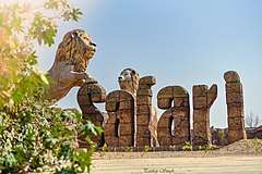
The uniqueness of Etawah Safari Park lies in the fact that while at other such places the animals remain caged and the tourists move freely in the area. While in Etawah Lion Safari, people will move in caged paths while the lions and other animals are seen moving freely in the jungle. The Lion Safari, which is mainly being developed to provide an alternate home to Asiatic lions, that are now limited only to Gir Forests in Gujarat will also feature a Lion Breeding Centre.[9]
National Chambal Sanctuary
National Chambal Sanctuary is spread over the Agra and Etawah districts, and a total of 290 different species of migratory and resident birds have been identified in the region so far. Winter is the best time to visit the sanctuary.[10] A boat ride in its tranquil waters during this time is an exhilarating experience with spectacular sightings of the big reptiles basking along the 180 km sparkling sand stretches in the morning sun. But the main draw of the sanctuary are the flamingoes that arrive here in November and stay till May. The Rudy Shelduck also arrives a little earlier in September & stays here till May. The Indian Skimmers have huge colonies in the sanctuary and breed prolifically here.
Sarsai Nawar Wetland
Sarsai Nawar Wetland is a Small wetland, en route to Saman Wildlife Sanctuary, in Etawah District of Uttar Pradesh. It comprises two small lakes that attract Sarus Cranes, White Ibis and other water birds in large numbers. It has a large population of the threatened species of Sarus Cranes, the world's tallest flying birds. Ten Sarus Crane pairs breed here regularly, which is more than twice the number of breeding pairs in the bird sanctuary of Bharatpur in Rajasthan. In winters, almost more than 40,000 migratory birds from northern arc visit Sarsai Nawar wetland.[11]
Agra-Etawah Cycle Highway

Agra-Etawah Cycle Highway in Uttar Pradesh now has Asia's first cycle highway. A first-of-its-kind project, the 207-km-long cycle highway runs between Etawah and Agra and was declared open on Saturday, 27 November 2016. The track begins from the lion safari in Etawah. On its way to Agra are tourist destinations like Naugava ka Quila, Raja Bhoj ki Haveli, and Bateshwarnath Temple. It ends at the eastern gate of the Taj Mahal in Agra.[12]
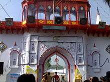
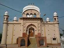
Notable Buildings
Religious
- Hajari Mahadev Temple Sarsai Nawar
- Kundeshwar Mahadev Temple
- Kali Vahan Mandir, Gwalior Road Etawah
- Neel Kanth Mahadev Mandir (Lord Shiva Temple)
- Maa Kalika Devi Mandir, Lakhna, Etawah
- Pachnada, Etawah
- Shahi Jama Masjid
- Sai Mandir
- Tixi Temple Etawah
- Pilua Mahavir
- Brahmani Devi
- Pili Kothi
- Nasia Ji Digambar Jain Temple
Notable people
References
- "{title}". Archived from the original on 10 February 2017. Retrieved 19 December 2016.
- "Urban Agglomerations/Cities having population 1 lakh and above" (PDF). Provisional Population Totals, Census of India 2011. Archived (PDF) from the original on 13 November 2011. Retrieved 7 July 2012.
- District Gazetteer Etawah (Uttar Pradesh). "History". Archived from the original on 19 June 2009. Retrieved 3 April 2010.
- The Delhi Sultanate: A Political and Military History, Cambridge Studies in Islamic Civilization, Peter Jackson, Cambridge University Press, 2003 p. 135
- Chisholm, Hugh, ed. (1911). . Encyclopædia Britannica. 9 (11th ed.). Cambridge University Press. p. 804.
- "Station: Etawah Climatological Table 1981–2010" (PDF). Climatological Normals 1981–2010. India Meteorological Department. January 2015. pp. 267–268. Archived from the original (PDF) on 5 February 2020. Retrieved 6 May 2020.
- Dixit, Neha. "Akhilesh Yadav in the family business". The Caravan. Retrieved 22 May 2019.
- https://www.m.timesofindia.com/city/kanpur/etawah-safari-opens-for-public-lion-segment-to-wait/amp_articleshow/72214891.cms
- https://www.zeenews.india.com/news/india/crocodiles-on-the-prowl-in-ups-etawah-villagers-fear-for-life_1935852.html/amp
- https://www.m.timesofindia.com/city/lucknow/6-up-wetlands-declared-ramsar-sites-this-year/amp_articleshow/74431796.cms
- https://www.m.timesofindia.com/city/agra/akhileshs-cycle-highway-inaugurated-four-months-ago-develops-cracks/amp_articleshow/57385825.cms
External links
| Wikimedia Commons has media related to Etawah. |