Aleosan
Aleosan, officially the Municipality of Aleosan, is a 3rd class municipality in the province of Cotabato, Philippines. According to the 2015 census, it has a population of 39,405 people.[3]
Aleosan | |
|---|---|
| Municipality of Aleosan | |
 Map of Cotabato with Aleosan highlighted | |
OpenStreetMap 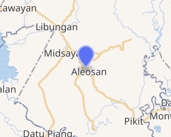
| |
.svg.png) Aleosan Location within the Philippines | |
| Coordinates: 7°09′31″N 124°34′32″E | |
| Country | |
| Region | Soccsksargen (Region XII) |
| Province | Cotabato |
| District | 1st District |
| Founded | April 6, 1982 |
| Barangays | 19 (see Barangays) |
| Government | |
| • Type | Sangguniang Bayan |
| • Mayor | Vicente C. Sorupia Jr. |
| • Vice Mayor | Eduardo C. Cabaya |
| • Congressman | Joselito S. Sacdalan |
| • Electorate | 23,325 voters (2019) |
| Area | |
| • Total | 225.44 km2 (87.04 sq mi) |
| Elevation | 33.4 m (109.6 ft) |
| Population (2015 census)[3] | |
| • Total | 39,405 |
| • Density | 170/km2 (450/sq mi) |
| • Households | 8,803 |
| Economy | |
| • Income class | 3rd municipal income class |
| • Poverty incidence | 50.86% (2015)[4] |
| • Revenue (₱) | 103,442,936.77 (2016) |
| Time zone | UTC+8 (PST) |
| ZIP code | 9415 |
| PSGC | |
| IDD : area code | +63 (0)64 |
| Climate type | tropical rainforest climate |
| Native languages | Hiligaynon Cebuano Maguindanao language Ilianen language Tagalog |
| Website | www |
Geography
Aleosan is within the political boundary of Cotabato Province. It is approximately 65 kilometres (40 mi) from the capital town of Amas which is barely two (2) hours ride from the seat of its municipal government. It is bounded on the west by Midsayap; on the north by Libungan and on the east and south by Pikit. It is accessible to land transportation from Cotabato City traversing the municipalities of Maguindanao to Kidapawan up to Davao City, as it is located along the major transport route linking the provinces of Maguindanao, Cotabato and Davao del Sur.
Barangays
Aleosan is politically subdivided into 19 barangays. [2] The seat of the municipal government is in barangay San Mateo.
- Bagolibas
- Cawilihan
- Dualing
- Dunguan*
- Katalicanan
- Lawili
- Lower Mingading
- Luanan
- Malapang
- New Leon
- New Panay
- Pagangan
- Palacat
- Pentil
- San Mateo (Poblacion)
- Santa Cruz
- Tapodoc
- Tomado*
- Upper Mingading
* - 2 barangays in Aleosan also are part of Bangsamoro despite North Cotabato and Aleosan are not under the administrative jurisdiction of the autonomous region.[5]
Climate
Aleosan area belongs to the fourth type of climate or the intermediate "E" with no distinct dry season. Rainfall is evenly distributed throughout the year with heavier rains from May to September. This type of climate conditions is suitable for the production of crops like rice, corn, mangoes, jackfruit, vegetables and root crops, which are considered seasonal crops and permanent crops like coconut, rubber, coffee, cacao and orchard crops.
| Climate data for Aleosan, Cotabato | |||||||||||||
|---|---|---|---|---|---|---|---|---|---|---|---|---|---|
| Month | Jan | Feb | Mar | Apr | May | Jun | Jul | Aug | Sep | Oct | Nov | Dec | Year |
| Average high °C (°F) | 31 (88) |
32 (90) |
33 (91) |
33 (91) |
32 (90) |
31 (88) |
30 (86) |
31 (88) |
31 (88) |
31 (88) |
31 (88) |
31 (88) |
31 (89) |
| Average low °C (°F) | 21 (70) |
21 (70) |
21 (70) |
22 (72) |
23 (73) |
23 (73) |
23 (73) |
23 (73) |
23 (73) |
23 (73) |
22 (72) |
22 (72) |
22 (72) |
| Average precipitation mm (inches) | 19 (0.7) |
14 (0.6) |
15 (0.6) |
18 (0.7) |
33 (1.3) |
42 (1.7) |
44 (1.7) |
42 (1.7) |
30 (1.2) |
31 (1.2) |
28 (1.1) |
17 (0.7) |
333 (13.2) |
| Average rainy days | 6.9 | 5.6 | 6.9 | 8.1 | 15.1 | 17.5 | 17.8 | 18.5 | 14.9 | 14.9 | 12.4 | 8.0 | 146.6 |
| Source: Meteoblue [6] | |||||||||||||
History
The name Aleosan is an acronym derived from the three (3) towns of Iloilo where majority of the early Christian settlers came from; A is for Alimodian, LEO is for Leon, and SAN for San Miguel.[7]
Parliamentary bill no. 670 authored by Assemblyman Jesus P. Amparo and co-authored by assemblymen Blah T. Sinsuat, Ernesto F. Roldan and Tomas B. Baga Jr. sought to establish and create the Municipality of Aleosan in the Province of Cotabato, which was ultimately approved and signed into law Batas Pambansa bilang 206 on April 6, 1982. For purposes of ratification, Proclamation No. 2188 was signed by President Ferdinand E. Marcos on April 29, 1982. A plebiscite was conducted on May 7, 1982, which was unanimously confirmed the desire and aspiration of the people in the nineteen (19) barangays to become a distinct and regular municipality from Pikit its mother municipality.
Demographics
| Population census of Aleosan | ||
|---|---|---|
| Year | Pop. | ±% p.a. |
| 1990 | 22,574 | — |
| 1995 | 25,408 | +2.24% |
| 2000 | 26,164 | +0.63% |
| 2007 | 32,874 | +3.20% |
| 2010 | 35,746 | +3.09% |
| 2015 | 39,405 | +1.87% |
| Source: Philippine Statistics Authority[3][8][9][10] | ||
In the 2015 census, the population of Aleosan, Cotabato, was 39,405 people,[3] with a density of 170 inhabitants per square kilometre or 440 inhabitants per square mile.
Economy
The municipality is endowed with abundant agricultural raw materials suitable for processing. These include coconut, banana, rubber, mango and coffee. There are small-scale enterprises but these are not sustainable due to inadequate capital. A cassava processing plant was shut down due to insufficient supply of raw materials and low quality of starch produced. The area however, is best suited for mango production and there is a need to develop the industry to cater the growing needs of the locality. The municipality's livestock industry has great potentials being one of the top producers and supplier of livestock in the province.
Tourist attractions
- Brgy Malapang – Mountain climbing
- Brgy Pentil – Eco tourism
- Brgy Katalicanan – UK Peak
References
- "Municipality". Quezon City, Philippines: Department of the Interior and Local Government. Retrieved 31 May 2013.
- "Province: North Cotabato". PSGC Interactive. Quezon City, Philippines: Philippine Statistics Authority. Retrieved 12 November 2016.
- Census of Population (2015). "Region XII (Soccsksargen)". Total Population by Province, City, Municipality and Barangay. PSA. Retrieved 20 June 2016.
- "PSA releases the 2015 Municipal and City Level Poverty Estimates". Quezon City, Philippines. Retrieved 12 October 2019.
- Arguilas, Carolyn (February 8, 2019). "Pikit's fate: 20 barangays remain with North Cotabato, 22 joining BARMM". Minda News. Retrieved February 9, 2019.
- "Aleosan, Cotabato: Average Temperatures and Rainfall". Meteoblue. Retrieved 16 March 2019.
- http://www.cotabatoprov.gov.ph/lgus/aleosan
- Census of Population and Housing (2010). "Region XII (Soccsksargen)". Total Population by Province, City, Municipality and Barangay. NSO. Retrieved 29 June 2016.
- Censuses of Population (1903–2007). "Region XII (Soccsksargen)". Table 1. Population Enumerated in Various Censuses by Province/Highly Urbanized City: 1903 to 2007. NSO.
- "Province of North Cotabato". Municipality Population Data. Local Water Utilities Administration Research Division. Retrieved 17 December 2016.