Conurbation
A conurbation is a region comprising a number of cities, large towns, and other urban areas that, through population growth and physical expansion, have merged to form one continuous urban or industrially developed area. In most cases, a conurbation is a polycentric urbanised area, in which transportation has developed to link areas to create a single urban labour market or travel to work area.[1]
| Population tables and ekistics of world cities |
|---|
.jpg) |
Patrick Geddes coined the term in his book Cities In Evolution (1915). He drew attention to the ability of the then new technology of electric power and motorised transport to allow cities to spread and agglomerate together, and gave as examples "Midlandton" in England, the Ruhr in Germany, Randstad in the Netherlands, and North Jersey in the United States.[2]
The term as described is used in Britain, whereas in the United States each polycentric "metropolitan area" may have its own common designation, such as San Francisco Bay Area or the Dallas–Fort Worth metroplex. Internationally, the term "urban agglomeration" is often used to convey a similar meaning to "conurbation".[3][4] A conurbation should also be contrasted with a megalopolis, where the urban areas are close but not physically contiguous, and where the merging of labour markets has not yet developed.
Africa
Mauritius
The cities and towns of Port Louis, Beau Bassin-Rose Hill, Curepipe, Quatre Bornes, Vacoas-Phoenix and other urbanized villages form a large and central conurbation on the island of Mauritius. A large part of this conurbation is located in the district of Plaines Wilhems. This network of urban areas has a total population of 606,650 (49% of the island's population) as of 2011.
Morocco
Nigeria
Lagos is a conurbation formed through the merged development of the initial Lagos city area with other cities and towns, such as Ikeja, Ojo, along with various suburban communities like Agege, Alimosho, Ifako-Ijaiye, Kosofe, Mushin, Oshodi and Shomolu.[6]
South Africa
Johannesburg, Ekurhuleni (East Rand), and Tshwane (greater Pretoria) are currently merging to form a region that has a population of 14.6 million.[7]
North America
Canada
Golden Horseshoe (Ontario)
The "Golden Horseshoe" is a densely populated and industrialized region centred on the west end of Lake Ontario in Southern Ontario, Canada. The largest cities in the region are Toronto, Mississauga, Oakville, Burlington, St. Catharines, Niagara Falls, Ontario, Brampton, and Hamilton.[8] If metropolitan areas which are somewhat distinct from the core urban area of the Golden Horseshoe by about 30 to 50 km of less developed and semi-rural land are included (similar to Combined Metropolitan Statistical Areas in the United States as defined by United States Office of Management and Budget), the total population is 8.8 million people, which is slightly over a quarter (25.6%) of the population of Canada, approximately 75% of Ontario's population and one of the largest metropolitan areas in North America.[9]
The larger area is named the Greater Golden Horseshoe and includes the metropolitan areas of Kitchener (including adjacent cities it is often referred to as Waterloo Region), Barrie, Guelph, Peterborough, and Brantford. The Greater Golden Horseshoe is also part of the Windsor-Quebec Corridor and its southeastern boundary is across the Niagara River from the Buffalo–Niagara Falls metropolitan area in the United States.
Greater Montreal (Quebec)
Greater Montreal is Canada's second-largest conurbation, with Statistics Canada defining the Census Metropolitan Area (CMA) as 4,258.31 square kilometres (1,644.14 sq mi) and a population of 3,824,221 as of 2011, which represents almost half of the population of the province of Quebec. Slightly smaller, there are 82 municipalities grouped under the Montreal Metropolitan Community to coordinate issues such as land planning, transportation, and economic development.
Lower Mainland (British Columbia)
British Columbia's Lower Mainland is the most populated area in Western Canada. It consists of many mid-sized contiguous urban areas, including Vancouver, North Vancouver (city and district municipality), West Vancouver, Burnaby, New Westminster, Richmond, Surrey, and Coquitlam, among others. The Lower Mainland population is around 2.5 million (as of 2011) and the area has one of the highest growth rates on the continent of up to 9.2 percent from the 2006 census.
National Capital Region (Ontario and Quebec)
The National Capital Region (NCR) is made up of the capital, Ottawa, and neighbouring Gatineau which is located across the Ottawa River. As Ottawa is in Ontario and Gatineau, Quebec, this is a unique conurbation. Federal government buildings are located in both cities and many workers live in one city and work in the other. The National Capital Region consists of an area of 5,319 square kilometres that straddles the boundary between the provinces of Ontario and Quebec. The area of the National Capital Region is very similar to that of the Ottawa-Gatineau Census Metropolitan Area (CMA) although the National Capital Region contains a number of small neighbouring communities that are not contained within the CMA. When all the communities are added, the population is around 1,500,000. Ottawa-Gatineau is the only CMA in the nation to fall within two provinces.
Mexico
Mexico City (CDMX)
The "CDMX" is the most densely populated center in North America. Greater Mexico City refers to the conurbation around Mexico City, officially called Valley of Mexico Metropolitan Area (Zona Metropolitana del Valle de México),[1] constituted by Mexico City itself composed of 16 Municipalities—and 41 adjacent municipalities of the states of Mexico and Hidalgo. For normative purposes,[further explanation needed] however, Greater Mexico City most commonly refers to the Metropolitan Area of the Valley of Mexico (Zona Metropolitana del Valle de México) an agglomeration that incorporates 18 additional municipalities. As of 2019 an estimated 27,782,000 people lived in Greater Mexico City, making it the largest metropolitan area in North America. It is surrounded by thin strips of highlands which separate it from other adjacent metropolitan areas, of which the biggest are Puebla, Toluca, and Cuernavaca-Cuautla, and together with which it makes up the Mexico City megalopolis.
United States
Puerto Rico
The Caribbean area, which is generally not considered to be part of a continent geographically speaking, has a conurbation in Puerto Rico consisting of San Juan, Bayamón, Guaynabo, Carolina, Canóvanas, Trujillo Alto, Toa Alta, Toa Baja, Cataño, and Caguas. This area is colloquially known as the "Área Metropolitana", and houses around 1.4 million inhabitants spread over an area of approximately 396.61 square kilometers (153.13 sq mi). Thus, making it the largest city in the Caribbean by area.
New York Tri-state area
One example of a conurbation is the expansive concept of the New York metropolitan area (the Tri-state region) centered on New York City, including 30 counties spread among New York State, New Jersey, Connecticut, and Pennsylvania, with an estimated population of 21,961,994 in 2007.[10] Approximately one-fifteenth of all U.S. residents live in the Greater New York City area. This conurbation is the result of several central cities whose urban areas have merged.
Greater Boston Area
Holding a population of 7,427,336 as of 2005, the Combined Statistical Area including Greater Boston consists of Boston proper and a collection of distinct but intertwined cities including Providence, Rhode Island, Worcester, Massachusetts, and Manchester, New Hampshire. Most importantly, the cities that compose the Greater Boston CSA are interlinked by heavy public transportation infrastructure, maintain continuously urban interstices, and hold mutual commuting patterns.
San Francisco Bay Area
Another conurbation is the combination of the metropolitan areas of San Francisco, Oakland, and San Jose and several minor urban centers with a combined population of nearly 8 million people, known as the San Francisco Bay Area.[11]
Greater Los Angeles Area
The Greater Los Angeles Area consists of the merging of several distinct central cities and counties, including Los Angeles, Orange County, Riverside, San Bernardino, and Ventura. This area is also often referred to simply as Southern California or colloquially as SoCal (a larger region which includes San Diego). In 2016, Southern California had a population of 23,800,500, making it slightly larger than the New York Tri-State Area, and is projected to remain so due to a faster growth rate. But because Southern California is not yet a recognized Combined Statistical Area by the United States Office of Management and Budget, the New York Tri-State Area officially remains the nation's largest as of now.
Greater Houston area
An example of a conurbation is seen in Greater Houston. Centered in Houston, the area is now a continuously urbanized from the coastal areas of Galveston extending through the northern side of the metro area, including The Woodlands, Conroe, and Spring, going up to Huntsville. The suburbs of Fort Bend County, Texas extend through the cities of the Galveston Bay Area and beyond to form a population of 7,197,883.[12]
Baltimore–Washington Area
The traditionally separate metropolitan areas of Baltimore and Washington, D.C. have shared suburbs and a continuous urbanization between the two central cities (Baltimore–Washington metropolitan area).
San Diego–Tijuana
The largest conurbation between the United States and Mexico, San Diego–Tijuana includes the two countries' busiest border crossing and a shared economy.[13]
Dallas—Fort Worth
Three large cities — Dallas, Fort Worth, and Arlington — make up this area. Each city is linked by bordering city limits or suburbs. The area is also known as the Dallas–Fort Worth “metroplex”, so called because has more than one principal anchor city of nearly equal size or importance, and is included in the emerging megalopolis known as the Texas Triangle. According to Texas Monthly, the term is a portmanteau of the terms "metropolitan" and "complex"[14] and was created by local advertising agency TracyLocke.[14] The North Texas Commission trademarked the term "Dallas/Fort Worth Metroplex" in 1972 as a replacement for the previously ubiquitous term "North Texas".[15] Urban areas with smaller secondary anchor cities (such as Mexico City, New York City, Los Angeles, Houston, Chicago and Phoenix) are not considered to be conurbations.
Detroit–Windsor
The major U.S. city of Detroit, Michigan lies immediately across the Detroit River from Windsor, Ontario in Canada. In many respects—economically, historically, culturally, socially, and, of course, geographically—Windsor is more a part of Metro Detroit than of Ontario. The two cities and their surrounding suburbs are commonly referred to collectively as the Detroit–Windsor area. The Detroit-Windsor border is the largest commercial border crossing in North America and the busiest between the two countries.[16]
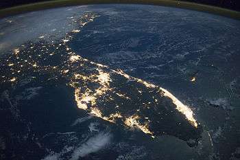
South Florida
The entire tri-county area also known as the Miami-Fort Lauderdale-West Palm Beach metropolitan area is now continuously urbanized along a roughly 100 miles (161 km) length of the Florida east coast as well as extending inland and continuing south of Miami as far as Florida City. Although this is generally all referred to as a single metropolitan area, not a conurbation, it is sometimes broken up into the Miami, Fort Lauderdale, and West Palm Beach metros.
Minneapolis - St. Paul
Minneapolis–Saint Paul is the most populous urban area in the state of Minnesota, and is composed of 182 cities and townships built around the Mississippi, Minnesota, and St. Croix rivers. The area is also nicknamed the Twin Cities for its two largest cities, Minneapolis, with the highest population, and Saint Paul, the state capital.
The Valley of the Sun
Phoenix, Arizona is the capital and most populous city in Arizona. It is the center of The Valley of the Sun, recognized by the United States Census Bureau as Chandler, Mesa, and Phoenix in the MSA. Other communities in the metropolitan area include Scottsdale, Glendale, Tempe, Gilbert, and Peoria.
The Front Range Urban Corridor
Denver, Colorado is the capital and most populous city in Colorado, as well as the most populous municipality in the Front Range Urban Corridor. This conurbation encompasses 18 counties in Colorado and Wyoming and had an estimated population of 4,976,781 in 2018, an increase of 14.84% since the 2010 United States Census.[17]
South America
Argentina
| Conurbation | Population | Year | Note | |
|---|---|---|---|---|
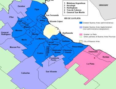 | Greater Buenos Aires | 13,641,973[18] | 2010 | Metro region excluding La Plata and its metro area (an additional 694,253 [ INDEC ]). |
- Greater Buenos Aires (12.046.799) – Greater La Plata (694.253) – Zárate / Campana
Brazil
The entire Rio–São Paulo area is also sometimes considered a conurbation, and plans are in the works to connect the cities with a high-speed rail. Yet the government of Brazil does not consider this area a single unit for statistical purposes, and population data may not be reliable.
| Conurbation | Population | Year | Note | |
|---|---|---|---|---|
 | CME São Paulo | 27,640,577[19] | 2009 | The CME of São Paulo is federally defined as the São Paulo Metro region (RMSP) and its conurbations. |
 | RM Rio de Janeiro | 12,330,186[20] | 2016 | Metropolitan region. |
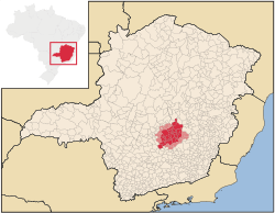 | RM Belo Horizonte | 5,916,189[21] | 2018 | Usually referred to as the Greater Belo Horizonte, comprising 34 municipalities and some 16 other surrounding cities. |
Colombia
| Conurbation | Population | Year | Note | |
|---|---|---|---|---|
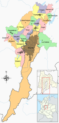 | Metropolitan Area of Bogotá | 10,733,206[22] | 2014 | Conurbation only between Bogota and Soacha |
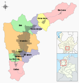 | Metropolitan Area of the Aburrá Valley | 3,821,797[22] | 2014 | Metro region |

Asia
China
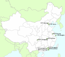
There are 3 well-known conurbations in China:[24]
- The Yangtze River Delta comprising Shanghai, Nanjing, Hangzhou and Ningbo, houses 150 million people and in 2016 it generated $2.76 trillion, 20 percent of China's national GDP. It is responsible for one-third of China's imports and exports.[25]
- The Jingjinji, comprising Tianjin, Beijing, Tangshan and Qinhuangdao, houses an estimated 130 million people and is responsible for a GDP of $1.1 trillion.[26]
- The Pearl River Delta including Guangzhou, Shenzhen, Dongguan, Hong Kong and Macau houses 60 million people and is responsible for a GDP of $1,5 trillion, 9% of China's national GDP.[27]
India
The Mumbai Metropolitan Region (MMR) consists of Mumbai and its satellite towns. Developing over a period of about 20 years, it consists of seven municipal corporations and fifteen smaller municipal councils. The region has an area of 4,355 km² and with a population of 20.5 million,[28] and is among the top ten most populated urban agglomerations in the world. It is linked together through the Mumbai Suburban Railway system and a large network of roads.
The National Capital Region (NCR) is a name for the coordinated planning region which encompasses the entire National Capital Territory of Delhi as well as several surrounding districts in the neighbouring states of Uttar Pradesh, Haryana and Rajasthan. However, since not all of the aforementioned areas are completely urban, the Delhi conurbation is actually limited to the NCT of Delhi and the neighbouring contiguous urban areas comprising Gurgaon, Faridabad, Noida, (Greater Noida) and Ghaziabad lying in "Central National Capital Region (CNCR)", a small part of overall NCR.[29] The population of this conurbation was estimated 21.7 million in 2011.[30] It is the world's third most populous urban agglomeration.
The APCRDA of Andhra Pradesh is a conurbation of three cities, namely Vijayawada, Eluru and Guntur and 11 other towns which include Mangalagiri, Tadepalle, Tenali, Ponnuru, Chilakaluripeta, Narasaraopeta, Sattenapally, Nandigama, Jaggayyapeta, Nuzividu, Gudivada and Vuyyuru. The new capital city of the state, Amaravati, is being developed between the cities of Vijayawada and Guntur at the center of the conurbation. The region holds a total population of 58 lakhs.
Bangladesh
Dhaka has recently been linked with Narayanganj and Gazipur city such that there are no gaps between Dhaka and those two cities.
Indonesia
Greater Jakarta or Jabodetabek comprises the largest urban area in Indonesia and the second-largest in the world with a population of around 30 million.[31] The center and national capital, Jakarta, has a population of 10.3 million within its borders.[32]
The second-most populated city in Indonesia, Surabaya, also forms a conurbation known as Gerbangkertosusila with a metropolitan population of about 10 million compared to the city proper of 3 million.[33] Conurbations are also present around Bandung and Medan.
Israel
- Gush Dan, Metropolitan Area of Tel Aviv, Central District (about 45% of the country's total population)
Japan
The Taiheiyō Belt is the largest conurbation in Japan in every sense, extending from Ibaraki Prefecture to Fukuoka Prefecture, running almost 1,200 km, with the total population of 82.9 million. However, it is rarely referred to in Japan itself with each Prefecture maintaining separate identities. The Greater Tokyo Area, also called Shutoken (the National Capital Region), is a metropolitan area in the Kantō region, with the estimated population of 35,676,000 in 2007, often referred to as the most populous and economically largest metropolitan area in the world.
Malaysia
The Klang Valley conurbation in the state of Selangor is composed of:
- Kuala Lumpur, the capital of Malaysia;
- Petaling Jaya;
- Ampang Jaya;
- Pandan Indah;
- Subang Jaya;
- Shah Alam;
- Klang;
- Selayang;
- Gombak;
- Putrajaya;
- Cyberjaya;
- Sepang; and
- Kajang.
The second largest conurbation by population in Malaysia is Greater Penang.[34][35] Centred in George Town, the capital city of the State of Penang, the conurbation also includes the following towns in Penang, and within the neighbouring states of Kedah and Perak.
- Butterworth
- Bukit Mertajam
- Perai
- Batu Kawan
- Nibong Tebal
- Sungai Petani, Kedah
- Kulim, Kedah
- Bandar Baharu, Kedah
- Parit Buntar, Perak
- Bagan Serai, Perak
The third largest conurbation by population in Malaysia is Iskandar Malaysia. Centred in Johor Bahru, the capital city of the state of Johor, the conurbation also includes the following towns in Johor that composed of:
- Johor Bahru, the centre of Iskandar Malaysia
- Tebrau
- Pasir Gudang
- Ulu Tiram
- Kempas
- Tampoi
- Skudai
- Iskandar Puteri
- Senai
- Kulai
- Pekan Nenas
Pakistan
- Karachi–Hyderabad, Sindh, is one of the largest metropolitan areas of the world, with a population exceeding 20 million (2017).
- Rawalpindi–Islamabad, also known as the twin cities of Pakistan, were built about 8 miles apart and have now completely intertwined into each other due to massive population growth and the expansion of both cities.
- Lahore–Raiwind–Kala Shah Kaku, the second largest city in Pakistan with its adjoining towns of Kala Shah Kaku and Raiwind.
Philippines
Metro Manila, also known as the National Capital Region, is a conurbation of the capital Manila, fifteen neighboring cities, and a small town to compose the largest urban center in the Philippines. Within the immediate periphery but not administratively part of the region, are cities and towns belonging to various provinces near the capital region. These include the cities of Antipolo, Bacoor, Meycauayan, San Jose del Monte and San Pedro; and the towns of Angono, Binangonan, Cainta, Cardona, Marilao, Obando, Rodriguez, San Mateo and Taytay.
Turkey
Asian part of Istanbul forms a conurbation together with Gebze, Darıca and Çayırova.[36] Each province has separate governments but they work in close coordination. Transport between Anatolian part of Istanbul and western end of Kocaeli is coordinated by both provinces and there are interprovincial urban buses between Kartal and İzmit,[lower-alpha 1] although each metropolitan municipality has a clear boundary of service.
Thailand
United Arab Emirates
The United Arab Emirates, while comprising seven distinct entities called emirates, each with its own Emirs, contains a significant conurbation formed by the agglomeration of the urban areas of three cities belonging to three separate Emirates. The Dubai-Sharjah-Ajman metropolitan area contains the urban areas of Dubai to the south, Sharjah in the middle and Ajman toward the north eastern end of the conurbation.[37] The total population is about 5.64 million people as of 2015 and as such, contributes to over 70% of the UAE population. Dubai is the major financial hub and Sharjah serves as an industrial, educational, cultural and major residential centre.
Vietnam
- Ho Chi Minh City Metropolitan Region: comprising Ho Chi Minh City (itself comprising the inner districts, Nhà Bè, Bình Chánh, Hóc Môn, Củ Chi and Cần Giờ); Bình Dương (itself comprising Thủ Dầu Một, Bến Cát, Tân Uyên, Thuận An, Dĩ An); Đồng Nai (itself comprising Biên Hòa and Long Khánh); Bà Rịa–Vũng Tàu (itself comprising Vũng Tàu, Bà Rịa, and Phú Mỹ); Tây Ninh (Tây Ninh); Long An (itself comprising Tân An and Kiến Tường); Bình Phước (itself comprising Đồng Xoài, Bình Long and Phước Long); Tiền Giang (itself comprising Mỹ Tho, Cai Lậy and Gò Công)
- Hanoi Metropolitan Region: comprising Hà Nội and the former province of Hà Tây (itself comprising Hà Nội's urban districts, Gia Lâm, Đông Anh, Mê Linh, Sóc Sơn, Hà Đông and Sơn Tây); Bắc Ninh (itself comprising Từ Sơn and Bắc Ninh); Thái Nguyên (itself comprising Thái Nguyên, Sông Công and Phổ Yên); Vĩnh Phúc (itself comprising Phúc Yên and Vĩnh Yên); Phú Thọ (itself comprising Phú Thọ and Việt Trì); Hòa Bình (Hòa Bình); Hưng Yên (ítelf comprising Hưng Yên and Mỹ Hào); Hải Dương (itself comprising Chí Linh and Hải Dương); Bắc Giang (Bắc Giang) and Phủ Lý (Hà Nam)
- Qui Nhơn-Nha Trang-Đà Lạt Conurbation Belt: comprising Qui Nhơn, An Nhơn (Bình Định), Sông Cầu, Tuy Hòa (Phú Yên), Ninh Hòa, Nha Trang, Cam Ranh (Khánh Hòa), Phan Rang (Ninh Thuận) and Đà Lạt (Lâm Đồng)
- Huế-Da Nang-Quảng Ngãi Conurbation Belt: comprising Huế, Hương Trà, Hương Thủy (Thừa Thiên - Huế), Đà Nẵng, Hội An, Tam Kỳ, Điện Bàn (Quảng Nam), and Quảng Ngãi (Quảng Ngãi)
Europe
Belgium
The Flemish Diamond (Dutch: Vlaamse Ruit) is the Flemish reference to a network of four metropolitan areas in Belgium, three of which are in the central provinces of Flanders, together with the Brussels Capital Region. It consists of four agglomerations which form the four corners of a diamond shape: Brussels, Ghent, Antwerp and Leuven. Over five million people live in this conurbation, with a population density of more than 800 per square kilometre. Actually, given the high level of commuting from and to Brussels every day, supported by one of the densest networks of railways and motorways in the world, It could be easily argued that the whole Belgium and Luxembourg area is one conurbation or is becoming one.
France
The most notable conurbation is Lille-Roubaix-Tourcoing-Villeneuve-d'Ascq, located in the north of France, with over 1.2 million people living in the area.[38] That conurbation is actually an international one as Belgian cities such as Tournai are increasingly playing the role of commuter town for Lille.
Germany
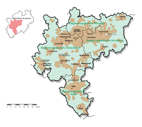
Germany has three conurbations along the River Rhine, namely Rhine-Main, Rhine-Neckar and Rhine-Ruhr. The Rhine-Ruhr is the largest conurbation in continental Europe and is a densely populated polycentric metropolitan region in the western part of Germany, comprising the three subregions of Ruhr Metropolitan Region, Düsseldorf-Mönchengladbach-Wuppertal Region and Cologne/Bonn Metropolitan Region. These three are all interlinked by a continuous urban settlement, while at the same time having cultural and economic differences.
Italy
Naples metropolitan area, that includes the whole metropolitan city of Naples, Caserta, Salerno and several other municipalities.[39][40]
Malta
Valletta Urban Area, the area around the Grand Harbour, is the main conurbation in Malta. It contains 27 of the Malta's 68 local councils including the capital Valletta. According to the Demographia, Valletta Urban Area has a population of 300,000,[41] while the European Spatial Planning Observation Network states that the functional urban area of Valletta has a population of 355,000,[42] which represents about 75% of Malta's population.
Netherlands
The Randstad is a densely populated area in the Netherlands with over 7 million inhabitants. It consists of a cluster of the four most populous cities of the country (Amsterdam, Rotterdam, The Hague and Utrecht) as well as several smaller cities, towns and urbanized villages.
Poland
Katowice Urban Area (aglomeracja katowicka', konurbacja górnośląska, GOP) is the largest conurbation in Poland, located in Upper Silesia, southern Poland. Around 5,294,000 million people live in the region — up 5.26% of the population of Poland.
United Kingdom
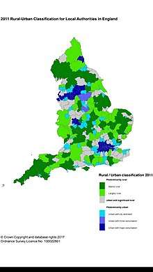
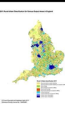
Industrial and housing growth in the United Kingdom during the 19th and early 20th centuries produced many conurbations. Greater London is by far the largest urban area and is usually counted as a conurbation in statistical terms, but differs from the others in the degree to which it is focused on a single central area. In the mid-1950s the Green Belt was introduced to stem the further urbanisation of the countryside in South East England.
The list below shows the most populous urban areas in the UK as defined by the Office for National Statistics (ONS). The Greater London Urban Area contains the whole of what is commonly called London, but ONS definitions divide London into a large number of smaller localities of which the largest is Croydon.
- Important Note: This lists UK urban areas only and excludes UK conurbations by definition of the term. As used in the UK, the term "conurbation" is closer to the meaning of urban agglomeration. For example, the Liverpool–Manchester or the Manchester–Liverpool conurbation[43] is defined as one conurbation by AESOP in a comparison report published by the University of Manchester in 2005 found here. The Liverpool–Manchester Conurbation has a population of 5.68 million.
Oceania
Australia
Canberra-Queanbeyan
A cross border built-up area compromising of the nation's capital Canberra in the Australian Capital Territory and the city of Queanbeyan in New South Wales, which is considered by the Australian Bureau of Statistics to have a single labour market.[47]
Greater Perth
The Perth Metropolitan Region, City of Mandurah and Pinjarra comprise a continuous urban area in Western Australia more than 130 km (80 miles) long, on a north–south axis – which is sometimes known as "Greater Perth" – and has a population of more than 2.05 million (2015).[48] Introduction of the Mandurah railway line in 2007 made it possible for commuters to travel the 70 km (43.5 mi) from Mandurah station to Perth station in 48 minutes.
South East Queensland
A built-up area 200 kilometres long,[49] centred on Brisbane, includes the local government areas (LGAs) of Gold Coast, Ipswich, Logan City, Moreton Bay, Redland City, Sunshine Coast and Tweed Heads, New South Wales. This area is served by a single public transport network, Translink.
Broader definitions of South East Queensland are also used, including the separate built-up area of Toowoomba (140 kilometres; 87 miles west of Brisbane), which is not part of the Translink network. Expansive definitions of South East Queensland give it a population of more than 3.4 million people (2014),[50] covers 22,420 square kilometres (8,660 sq mi), incorporates ten LGAs and extends 240 kilometres (150 mi) from Noosa in the north to the Gold Coast (some sources include Tweed Heads).
New Zealand
In 2010 Auckland became a unitary authority encompassing seven former city and district councils including Auckland City, Manukau City, North Shore City and Waitakere City as well as a number of smaller towns, rural area and the islands of the Hauraki Gulf. Auckland Council is the largest council in Australasia and the region has a population of 1,529,300, being almost 33% of the total population of New Zealand. Long before formal recognition, the entire urban area rather than the constituent administrative city was often referred to as “Auckland” by New Zealanders.
The Wellington Metropolitan Area compromises the four cities of Wellington City, Porirua and the cities of Lower Hutt and Upper Hutt, together known as Hutt Valley. The Wellington Metropolitan Area is the second largest Urban population in New Zealand with a population of 409,200.
See also
| Look up conurbation in Wiktionary, the free dictionary. |
References
- "zconurbation". Encyclopedia.com.
- Hall, Peter (2002). Cities of Tomorrow. ISBN 978-0-631-23252-0.
- "World Urbanization Prospects - Population Division - United Nations". Retrieved 2020-04-16.
- "Vision of Britain - Guide to Census Reports - Census Geographies". Visionofbritain.org.uk.
- "Sale, Morocco". Encyclopedia2.thefreedictionary.com.
- "EzineArticles Submission - Submit Your Best Quality Original Articles For Massive Exposure, Ezine Publishers Get 25 Free Article Reprints". Goarticles.com.
- Baker, Deane-Parker (15 September 2010). "South Africa's threat environment: a guide for the National Planning Commission". African Security Review. 19 (3): 54–64. doi:10.1080/10246029.2010.519878. ISSN 1024-6029.
...what military force would relish tackling Johannesburg, Ekurhuleni (the East Rand) and Tshwane (greater Pretoria), which will by 2015 be a single polycentric urban region...
- "Places to Grow Act, 2005". Government of Ontario. Retrieved 2012-07-25.
- "Portrait of the Canadian Population in 2006: Sub-provincial population dynamics, Greater Golden Horseshoe". Statistics Canada, 2006 Census of Population. 2007-03-13. Retrieved 2007-03-13.
- "Annual Estimates of the Population of Combined Statistical Areas: April 1, 2000 to July 1, 2007" (CSV). 2007 Population Estimates. United States Census Bureau, Population Division. 2008-03-27. Retrieved 2008-05-26.
- "Bay Area Census". Bayareacensus.ca.gov. Retrieved 27 November 2018.
- Bureau, U. S. Census. "U.S. Census website". United States Census Bureau. Retrieved 2019-11-17.
- Loucky, James, ed. (2008). Transboundary policy challenges in the Pacific border regions of North America. University of Calgary Press. p. 8. ISBN 978-1-55238-223-3. Retrieved February 19, 2011.
- Texas Monthly (2013). "Don't Call It the Metroplex".
- North Texas Commission (2013). "History". Archived from the original on October 4, 2013. Retrieved October 1, 2013.
- The Canada-U.S. border: by the numbers – Canada – CBC News. Cbc.ca (2011-12-07). Retrieved on 2013-07-16.
- "Estimates of the Components of Resident Population Change for Counties: April 1, 2010 to July 1, 2018". 2018 Population Estimates. United States Census Bureau, Population Division. July 1, 2018. Archived from the original on February 13, 2020. Retrieved June 8, 2019.
- Greater Buenos Aires – 2010 Census provisional results Archived 2012-09-01 at the Wayback Machine
- "ESTIMATIVAS DAS POPULAÇÕES RESIDENTES, EM 1º DE JULHO DE 2009, SEGUNDO OS MUNICÍPIOS" (PDF). Ibge.gov.br. Retrieved 27 November 2018.
- "IBGE :: Instituto Brasileiro de Geografia e Estatística". Ibge.gov.br.
- "IBGE :: Instituto Brasileiro de Geografia e Estatística". Ibge.gov.br.
- "DANE". Archived from the original on 13 November 2009. Retrieved 25 December 2014.
- INEI. "Instituto Nacional de Estadistica e Informatica". M.inei.gob.pe. Retrieved 27 November 2018.
- Williams, Alan (2009). Contemporary Issues Shaping China's Civil Aviation Policy: Balancing International With Domestic Priorities. Burlington, Vermont: Ashgate Publishing Company. p. 34. ISBN 978-0-7546-9183-9.
- "The Yangtze River Delta Integration Plan - China Briefing News". China-briefing.com. 6 June 2018. Retrieved 27 November 2018.
- "China plans a city the size of New England that'll be home to 130 million". Nbcnews.com. Retrieved 27 November 2018.
- "Pearl River Delta: China's Megacity - Salini Impregilo Digital Magazine". Webuildvalue.com. Retrieved 27 November 2018.
- "Mumbai Metropolitan Region Development Authority - About MMR". Mmrda.maharashtra.gov.in. Retrieved 2018-01-30.
- Singh, Govind; Deb, Mihir; Ghosh, Chirashree (2018). "Delimiting the Boundary of Delhi for Effective Urban Political Ecology Investigations". Journal of Innovation for Inclusive Development. 3 (1): 31–39.
- "NCR population shot up by 40% in 10 years". The Times of India.
- Younger, John Scott; Parry, David Emlyn; Lubis, Harun A.; McLernon, Andrew; Wignall, David John; Hasan, Danni; Benton, Gordon G. (December 2015). "Greater Jakarta, the world's second largest conurbation – part 1". Proceedings of the Institution of Civil Engineers - Municipal Engineer. 168 (4): 253–261. doi:10.1680/jmuen.14.00050.
- "Statistik Daerah Provinsi DKI Jakarta 2017". BPS Provinsi DKI Jakarta. Statistics Indonesia. Retrieved 23 January 2018.
- The Report: Indonesia 2015. Oxford Business Group. 2015. p. 259. ISBN 9781910068335.
- "Biggest Cities In Malaysia". Worldatlas.com. Retrieved 2018-06-12.
- hermes (2016-03-24). "JB can be Malaysia's second-biggest city: Johor Sultan". The Straits Times. Retrieved 2018-06-12.
- Ekinci, Deniz; Sönmez, Emin. "İstanbul konürbasyonunun yeni habitat adacığında CBS tabanlı jeoekoloji planlama analizi". Turkish Journal of Geography. 46: 147–167.
- News, Sultan Sooud Al Qassemi, Special to Gulf (2012-06-19). "Infinite possibilities for Dubai-Sharjah-Ajman conurbation". Gulfnews.com. Retrieved 2018-10-16.
- Romain Garbaye (22 July 2011). Getting Into Local Power: The Politics of Ethnic Minorities in British and French Cities. John Wiley & Sons. pp. 1828–. ISBN 978-1-4443-5554-3.
- Lida Viganoni (2007). Il Mezzogiorno della città: tra Europa e Mediterraneo (in Italian). FrancoAngeli. pp. 175–. ISBN 978-88-464-8428-4.
- Domenico Smarrazzo (1999). Area metropolitana di Napoli - SVIMEZ (PDF) (in Italian). Maggioli Editore.
- World Urban Areas – Demographia, 2014
- Study on Urban Functions Archived 2015-09-24 at the Wayback Machine – European Spatial Planning Observation Network, 2007
- Schulze Bäing, Andreas. "Shrinking cities and growing regions – emerging trends of new rural-urban relationships in the UK and Germany". AESOP University of Manchester. Retrieved 19 March 2015.
- "2011 Census - Built-up areas". ONS. Retrieved 1 July 2013.
- Mid-2012 Population Estimates for Settlements and Localities in Scotland General Register Office for Scotland
- The UK's major urban areas Office for National Statistics (Urban area of Belfast and connected settlements, Table 3.1, page 47)
- "Main Features - Statistical Areas Level 4". Abs.gov.au.
- Statistics, c=AU; o=Commonwealth of Australia; ou=Australian Bureau of. "Main Features - Main Features". Abs.gov.au.
- Moore, Tony (22 June 2015). "SEQ's 200-kilometre urban sprawl prediction comes true: planning expert". Brisbane Times.
- "3218.0 - Regional Population Growth, Australia, 2013-14". Australian Bureau of Statistics. Archived from the original on 2016-03-27. ERP at 30 June 2014.
- İETT route 17B (http://www.iett.istanbul/tr/main/hatlar/17b), Ulaşım Park route 200(https://e-komobil.com/ )
Further reading
- Patrick Geddes – "Cities In Evolution"
- Edward Soja – "Postmetropolis"