North Vancouver (city)
The City of North Vancouver is a waterfront municipality on the north shore of Burrard Inlet, directly across from Vancouver, British Columbia. It is the smallest of the three North Shore municipalities, and the most urbanized as well. Although it has significant industry of its own, including shipping, chemical production, and film production, the city is usually considered to be a suburb of Vancouver. The city is served by the Royal Canadian Mounted Police, British Columbia Ambulance Service, and the North Vancouver City Fire Department.
North Vancouver | |
|---|---|
| The Corporation of the City of North Vancouver | |
 | |
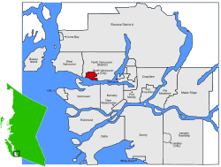 Location of City of North Vancouver within the Metro Vancouver area in British Columbia, Canada | |
| Coordinates: 49°19′N 123°4′W | |
| Country | Canada |
| Province | British Columbia |
| Regional District | Metro Vancouver |
| Incorporated | 1907 |
| Government | |
| • Mayor | Linda Buchanan |
| • MP | Jonathan Wilkinson (Liberal) |
| • MLA | Bowinn Ma (BC NDP) |
| Area | |
| • City | 11.83 km2 (4.57 sq mi) |
| Elevation | 80 m (260 ft) |
| Population (2016) | |
| • City | 52,898 (ranked 100th) |
| • Density | 4,465.1/km2 (11,565/sq mi) |
| • Urban | 84,412 |
| Time zone | UTC-8 (PST) |
| • Summer (DST) | UTC-7 (PDT) |
| Forward sortation area | V7G - V7R |
| Area code(s) | 604, 778 |
| Website | City of North Vancouver official website |
History
Moodyville (at the south end of Moody Avenue, now Moodyville Park), is the oldest settlement on Burrard Inlet, predating Vancouver; only New Westminster is the older non-native settlement in the region. Logging came to the virgin forests of Douglas Fir in North Vancouver, as sailing ships called in to load. A water-powered sawmill was set up in the 1860s at Moodyville, by Sewell Moody. Subsequently, post offices, schools and a village sprang up. In time, the municipality of North Vancouver (which encompassed the entire North Shore from Deep Cove to Horseshoe Bay) was incorporated in 1891. In the 1880s, Arthur Heywood-Lonsdale and a relation James Pemberton Fell, made substantial investments through their company, Lonsdale Estates, and in 1882 he financed the Moodyville investments. Several locations in the North Vancouver area are named after Lonsdale and his family.[1]
The cost of developing the raw mountainous terrain was high and the ocean foreshore was primarily swamp. The distances, rivers and streams that swelled in to destructive debris torrents with the annual snow melt and heavy rainfall, often washed out the many bridges that were required. Not long after the District was formed, an early land developer and second reeve of the new council, James Cooper Keith, personally underwrote a loan[2] to commence construction of a road which undulated from West Vancouver to Deep Cove amid the slashed sidehills, swamps, and burnt stumps. The road, sometimes under different names and not always contiguous, is still one of the most important east-west thoroughfare carrying traffic across the North Shore.
Development was slow at the outset. The population of the District in the 1901 census was only 365 people.[2] Keith joined Edwin Mahon and together they controlled North Vancouver Land & Improvement Company. Soon the pace of development around the foot of Lonsdale began to pick up. The first school was opened in 1902. The District was able to build a municipal hall in 1903 and actually have meetings in North Vancouver (instead of in Vancouver where most of the landowners lived). The first bank and first newspaper arrived in 1905. In 1906 the BC Electric Railway Company opened up a street car line that extended from the ferry wharf up Lonsdale to 12th Street. By 1911 the streetcar system extended west to the Capilano River and east to Lynn Valley.
The owners of businesses who operated on Lonsdale, as part of an initiative lead by Keith and Mahon, brought a petition to District Council in 1905 calling for a new, compact city to be carved out of the unwieldy district.
During the ensuing two years there was much and sometimes heated debate. Some thought the new City should have a new name such as Northport, Hillmont or Parkhill. Burrard became the favourite of the new names but majority view was that North Vancouver remain in order to remain associated with the rising credibility of Vancouver in financial markets and as a place to attract immigrants.[3]
Some thought the boundary of the new City should reflect geography and extend from Lynn Creek or Seymour River west to the Capilano River and extend three miles up the mountainside. That the boundary of the City which came into existence in 1907 just happened to match that of the lands owned by the North Vancouver Land & Improvement Company and Lonsdale Estate was no accident. Since the motivation for creating the City was to reserve local tax revenue for the work of putting in services for the property owned by the major developers, there was little reason to take on any of the burden beyond the extent of their holdings.
Residents in west part of the District of North Vancouver now had less reason to be connected with what remained and they petitioned to create the District of West Vancouver (the west part of the North Shore, not the west side of Vancouver) in 1912. The eastern boundary of that new municipality is for the most part the Capilano River and a community that is easily distinguished from the two North Vancouvers has since developed.
The City of North Vancouver continued to grow around the foot of Lonsdale Avenue. Serviced by the North Vancouver Ferries, it proved a popular area. Commuters used the ferries to work in Vancouver. Street cars and early land speculation, spurred interest in the area. Streets, city blocks and houses were slowly built around lower Lonsdale. Wallace Shipyards, and the Pacific Great Eastern Railway provided an industrial base, although, the late arrival of the Second Narrows railway bridge in 1925 controlled development.
Sawmills, logging, and small farms continued in the interwar years. Yet the nearby mountains also proved to be a permanent attraction. Ski areas were set up on Grouse Mountain and Mount Seymour.
The North Vancouver mountains have many drainages: Capilano River, MacKay, Mosquito, and Lynn Creeks, and Seymour River. The Depression again bankrupted the city, while the Second World War turned North Vancouver into the Clydeside of Canada with a large shipbuilding program. Housing the shipyard workers provided a new building boom, which continued on through the post-war years. By that time, North Vancouver became a popular housing area.
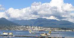
The area around lower Lonsdale Avenue features several open community spaces, including Waterfront Park, Lonsdale Quay, Ship Builders Square and the Burrard Dry Dock Pier.
Geography
The City of North Vancouver is separated from Vancouver by the Burrard Inlet, and it is surrounded on three sides by the District of North Vancouver.
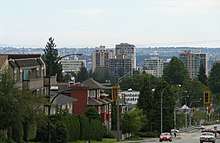
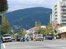
The City of North Vancouver is relatively densely populated with a number of residential high-rise buildings in the Central Lonsdale and Lower Lonsdale areas.
The city has much in common with the District Municipality of North Vancouver and together with West Vancouver are commonly referred to as the North Shore.
Climate
North Vancouver has an oceanic climate (Köppen climate type Cfb).
| Climate data for North Vancouver (N Vancouver 2ND Narrows) (Elevation: 4m) 1981−2010 | |||||||||||||
|---|---|---|---|---|---|---|---|---|---|---|---|---|---|
| Month | Jan | Feb | Mar | Apr | May | Jun | Jul | Aug | Sep | Oct | Nov | Dec | Year |
| Average precipitation mm (inches) | 262.2 (10.32) |
172.3 (6.78) |
168.4 (6.63) |
136.3 (5.37) |
103.3 (4.07) |
82.5 (3.25) |
53.2 (2.09) |
54.9 (2.16) |
76.8 (3.02) |
189.0 (7.44) |
293.4 (11.55) |
238.6 (9.39) |
1,830.8 (72.08) |
| Average rainfall mm (inches) | 255.3 (10.05) |
167.7 (6.60) |
166.8 (6.57) |
136.1 (5.36) |
103.3 (4.07) |
82.5 (3.25) |
53.2 (2.09) |
54.9 (2.16) |
76.8 (3.02) |
189.0 (7.44) |
290.2 (11.43) |
229.9 (9.05) |
1,805.6 (71.09) |
| Average snowfall cm (inches) | 6.9 (2.7) |
5.2 (2.0) |
1.6 (0.6) |
0.2 (0.1) |
0.0 (0.0) |
0.0 (0.0) |
0.0 (0.0) |
0.0 (0.0) |
0.0 (0.0) |
0.1 (0.0) |
2.3 (0.9) |
8.7 (3.4) |
24.9 (9.8) |
| Average precipitation days (≥ 0.2 mm) | 20.5 | 15.5 | 18.0 | 15.4 | 13.8 | 11.7 | 7.4 | 6.7 | 9.6 | 16.1 | 20.9 | 20.3 | 175.9 |
| Average rainy days (≥ 0.2 mm) | 19.7 | 15.1 | 17.9 | 15.4 | 13.8 | 11.7 | 7.4 | 6.7 | 9.6 | 16.0 | 20.7 | 19.6 | 173.5 |
| Average snowy days (≥ 0.2 cm) | 1.7 | 0.92 | 0.54 | 0.12 | 0.0 | 0.0 | 0.0 | 0.0 | 0.0 | 0.08 | 0.72 | 2.2 | 6.2 |
| Source: Environment Canada (normals, 1981−2010)[4] | |||||||||||||
People and politics
| Mayor | Linda Buchanan (2018) |
| Councillors | Holly Back (2018); Don Bell (2011, 2014, 2018); Angela Girard (2018); Tina Hu (2018), Jessica McIlroy (2018); Tony Valente (2018) |
| Provincial MLA | Bowinn Ma (North Vancouver-Lonsdale) |
| MP | Jonathan Wilkinson (North Vancouver) |
Sites of interest
Sites of interest in the city include:[5][6][7]
- Centennial Theatre, 2300 Lonsdale Avenue
- First Church of Christ, Scientist, a local heritage site
- North Vancouver Museum & Archives, 209 West 4th Street
- The Polygon Gallery
- Presentation House Theatre, 333 Chesterfield Avenue
- St. Edmund's Church, 535 Mahon Avenue, a local heritage site
- Trans Canada Trail Pavilion, Waterfront Park
- The Shipyards, near Lonsdale Quay, which includes Ship Builders Square and the Burrard Dry Dock Pier, on the site of the old Wallace Shipyard
- Lonsdale Quay Market, easily accessible from the Seabus. The Quay has a view of Vancouver's skyline and is locally owned and operated.
Transportation
The City of North Vancouver is connected to Vancouver by two highway bridges (the Lions' Gate Bridge and the Ironworkers Memorial Second Narrows Crossing) and by a passenger ferry, the SeaBus. That system and the bus system in North Vancouver is operated by Coast Mountain Bus Company, an operating company of Translink. The hub of the bus system is Lonsdale Quay, the location of the SeaBus terminal.
The main street in the city is Lonsdale Avenue, which begins at Lonsdale Quay and goes north to 29th Street, where it continues in the District of North Vancouver, ending at Rockland Road.
Highway 1, part of the Trans-Canada Highway (often referred to as the "Upper Levels Highway") passes through the northern portion of the city. It is a freeway for its entire length within the City of North Vancouver. There are three interchanges on Highway 1 within the City of North Vancouver:
- Lynn Valley Road (Exit 19)
- Lonsdale Avenue (Exit 18)
- Westview Drive (Exit 17)
Education
Public schools are managed by the North Vancouver School District, which operates 8 high schools and 30 elementary schools shared by the city and the District of North Vancouver.
The Conseil scolaire francophone de la Colombie-Britannique operates one Francophone school in that city: école André-Piolat, which has both primary and secondary levels.[8]
There are also several independent private elementary and high schools in the area, including Bodwell High School and Lions Gate Christian Academy.
Post-secondary education is available at Capilano University in the district, as well as at Simon Fraser University and the University of British Columbia in neighbouring communities.
Demographics
| Canada 2016 Census[9] | Population | % of Total Population | |
|---|---|---|---|
| Visible minority group |
West Asian | 4,360 | 8.4% |
| Filipino | 3,450 | 6.6% | |
| Chinese | 2,290 | 4.4% | |
| South Asian | 1,840 | 3.5% | |
| Korean | 1,155 | 2.2% | |
| Latin American | 840 | 1.6% | |
| Japanese | 815 | 1.6% | |
| African | 485 | 0.9% | |
| Southeast Asian | 265 | 0.5% | |
| Arab | 215 | 0.4% | |
| Other visible minority | 140 | 0.3% | |
| Mixed visible minority | 490 | 0.9% | |
| Total visible minority population | 16,340 | 36% | |
| Aboriginal | 1,650 | 3.2% | |
| European | 34,040 | 65.2% | |
| Total population | 52,898 | 100% | |
According to the 2011 Canadian Census,[10] the population of North Vancouver is 48,196, a 6.7% increase from 2006. The population density is 4,073.8 people per square km. The median age is 41.2 years old, which is a bit higher than the national median age at 40.6 years old. There are 24,206 private dwellings with an occupancy rate of 94.1%. According to the 2011 National Household Survey, the median value of a dwelling in North Vancouver is $599,985 which is significantly higher than the national average at $280,552. The median household income (after-taxes) in North Vancouver is $52,794, a bit lower than the national average at $54,089.
North Vancouver has one of the highest West Asian population ratios for any Canadian city at 7.2%. The racial make up of North Vancouver is:
- 68.8% European Canadian
- 7.9% East Asian; 3.8% Chinese, 2.5% Korean, 1.6% Japanese
- 7.3% Southeast Asian; 7.0% Filipino
- 7.2% West Asian
- 3.1% South Asian
- 2.0% Aboriginal; 1.4% First Nations, 0.6% Metis
- 1.2% Latin American
- 0.8% Black
- 0.5% Arab
- 1.1% Multiracial; 1.7% including Metis
- 0.1% Other
Most residents of North Vancouver are either Christian (47.4%), or affiliated with no religion (41.7%). The remaining 10.9% of residents are affiliated with another religion.
For residents from the age of 25 years to 64; 95.3% have a high school diploma (or equivalent too), 75.6% have a post-secondary degree, and only 4.7% don't have any certificate, diploma or degree.
According to the 2001 Statistics Canada Census:
- Population: 44,303
- % Change (1996–2001): 6.8
- Dwellings: 21,217
- Area (km².): 11.95
- Density (persons per km².): 3706.2
- Has the highest level of fitness of any city in Canada.
Population estimates according to BC Stats:
| 1996+ | 1997 | 1998 | 1999 | 2000 | 2001+ | 2002 | 2003 | 2004 | 2005 | 2006 |
|---|---|---|---|---|---|---|---|---|---|---|
| 43,268 | 43,725 | 44,550 | 44,938 | 45,489 | 46,236 | 46,977 | 46,496 | 46,831 | 48,037 | 49,248 |
| Canada 2006 Census | Population | % of Total Population | |
|---|---|---|---|
| Visible minority group Source:[11] | South Asian | 1,340 | 3% |
| Chinese | 2,205 | 4.9% | |
| Black | 315 | 0.7% | |
| Filipino | 1,910 | 4.3% | |
| Latin American | 430 | 1% | |
| Arab | 90 | 0.2% | |
| Southeast Asian | 240 | 0.5% | |
| West Asian | 3,065 | 6.8% | |
| Korean | 1,160 | 2.6% | |
| Japanese | 630 | 1.4% | |
| Other visible minority | 45 | 0.1% | |
| Mixed visible minority | 340 | 0.8% | |
| Total visible minority population | 11,775 | 26.2% | |
| Aboriginal group Source:[12] | First Nations | 670 | 1.5% |
| Métis | 225 | 0.5% | |
| Inuit | 0 | 0% | |
| Total Aboriginal population | 925 | 2.1% | |
| White | 32,160 | 71.7% | |
| Total population | 44,860 | 100% | |
Languages
Mother Languages as reported by each person: Source:[13]
| Canada 2011 Census | Population | % of Total Population | % of Non-official language Population |
|---|---|---|---|
| English | 31,550 | 66.0 | N/A |
| Persian | 3,505 | 7.3 | 22.8 |
| Tagalog | 1,700 | 3.6 | 11.0 |
| Korean | 1,225 | 2.6 | 8.0 |
| Spanish | 855 | 1.8 | 5.6 |
| German | 790 | 1.8 | 5.1 |
| French | 710 | 1.5 | N/A |
Surrounding municipalities
Places adjacent to North Vancouver (city) | ||||||||||
|---|---|---|---|---|---|---|---|---|---|---|
| ||||||||||
References
- Canada North Shore News
- Francis, Daniel (2016). Where Mountains Meet the Sea. Harbour Publishing Co. P.O. Box 219, Madeira Park, BC V0N 2H0: Harbour Publishing. p. 77. ISBN 978-1-55017-751-0.CS1 maint: location (link)
- Sommer, Warren (2007). The Ambitious City: A History of the City of North Vancouver. Madeira Park, BC V0N 2H0: Harbour Publishing. pp. 64, 83, 93, 94. ISBN 978-1-55017-411-3.CS1 maint: location (link)
- "N VANCOUVER 2ND NARROWS]". Canadian Climate Normals 1981−2010. Retrieved 26 March 2018.
- Historic places in North Vancouver
- "Attractions in North Vancouver". Archived from the original on 23 July 2012. Retrieved 25 May 2009.
- Primary historic buildings in North Vancouver Archived 19 August 2007 at the Wayback Machine
- "Carte des écoles." Conseil scolaire francophone de la Colombie-Britannique. Retrieved on 22 January 2015.
- "Census Profile, 2016 Census North Vancouver, City [Census subdivision]". Statistics Canada. 24 April 2018. Retrieved 18 January 2019.
- 2011 NHS/Census Profile of North Vancouver: http://www12.statcan.gc.ca/nhs-enm/2011/dp-pd/prof/details/page.cfm?Lang=E&Geo1=CSD&Code1=5915051&Data=Count&SearchText=north%20vancouver&SearchType=Begins&SearchPR=01&A1=All&B1=All&Custom=&TABID=1
- Vancouver&SearchType=Begins&SearchPR=01&B1=All&Custom=, Community Profiles from the 2006 Census, Statistics Canada - Census Subdivision
- , Aboriginal Peoples - Data table
- , Focus on Geography Series, 2011 Census-Census subdivision of North Vancouver, CY - British Columbia
External links
| Wikimedia Commons has media related to North Vancouver, British Columbia (city). |
| Wikivoyage has a travel guide for North Vancouver. |
Municipalities of Metro Vancouver | |
|---|---|
| Population over 500,000 | |
| Population over 100,000 | |
| Population over 50,000 | |
| Population over 10,000 | |
| Population under 10,000 | |
| Unincorporated areas | |
| |
| Subdivisions |  | |
|---|---|---|
| Communities | ||
| Metro areas and agglomerations |
| |
| Cities |
| |
| ||
| Authority control |
|
|---|