Kartal
| ||||||||||||||||||||||||||||||||||||||||||||||||||||||||||||||||||||||||||||||||||||||||||||||||||||||||||||||||||||||||||||||||||||||||||||||||||||||||||||||||||||||||||||||||||||||||||||||||||||||||||||||||||||||||||||||||||||||||||||||||||||||||||||||||||||||||||||||||||||||||||||||||||||||||||||||||||||||||||||||||||||||||||||||||||||||||||||||||||||||||||||||||||||||||||||||||||||||||||
Kartal | |
|---|---|
district | |
 | |
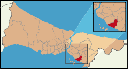 Location of Kartal in Istanbul | |
 Kartal Location of Kartal in Istanbul | |
| Coordinates: 40°54′39″N 29°09′42″E | |
| Country | Turkey |
| City | Istanbul |
| Settled | 6th century |
| Government | |
| • Mayor | Gökhan Yüksel (CHP) |
| • Governor | Abdullah Demir |
| Area | |
| • District | 34.43 km2 (13.29 sq mi) |
| Population (2018)[2] | |
| • District | 461.155 |
| • District density | 13/km2 (35/sq mi) |
| Time zone | UTC+2 (EET) |
| • Summer (DST) | UTC+3 (EEST) |
| Area code(s) | 0-216 |
| Website | www |
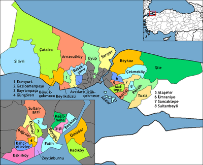
Kartal is a district of Istanbul, Turkey, located on the Asian side of the city, on the coast of the Marmara Sea between Maltepe and Pendik.
Despite being far from the city centre, Kartal is heavily populated (total population of 541,209) (2008 census). The total land area is 147,000 m2 which includes some countryside areas inland. Her neighbours are Maltepe the west, Sultanbeyli and Sancaktepe the north and Pendik the east.
It was the neighbour of Gebze (1923–1987), Şile (1923–1987), Beykoz (1928–1987), Üsküdar (1923–1987), Ümraniye (1987–2009) and Kadıköy (1928–1992 and 2004–2009). It was a neighbour again with Kadıköy from the northwest due to Ferhatpaşa quarter passed from Maltepe to Samandıra in 2004. However, this neighbourhood was ended with Ataşehir's separation from Kadıköy and Samandıra's separation (joined to Sancaktepe) from Kartal in 2009.
History
The center of Kartal (meaning 'eagle' in Turkish) was a fishing village on the Marmara shore during the Byzantine Empire called Kartalimen or Kartalimin in Greek, and was founded at the beginning of the 6th century. In the 11th century, the town was conquered by the ruler of the Seljuks, Suleyman Shah, and then in 1329 Kartal became part of the Ottoman Empire (however, the Byzantines re-took the city in 1403 and held it for 17 years).[3][4]
According to the Ottoman General Census of 1881/82-1893, the kaza of Kartal had a total population of 12.969, consisting of 6.920 Greeks, 5.095 Muslims, 869 Armenians, 3 Catholics, 1 Jew and 81 foreign citizens.[5]
By 1947, Kartal was an industrial area and with the introduction of commuter trains to Haydarpaşa Terminal from Gebze in 1973, Kartal became even more important as an industrial area of Istanbul.
The current trend is that as more and more housing is built near the coast, factories there are being closed down and moved inland. For example, the large cement factory on the shore, which is to be converted into a cultural center, was closed in 2003.[6]
There is an historical Roman bath ruin near the Dragos Hill, which was under use of late Roman era is recovering by the Istanbul Archaeology Museums with the financial support of Kartal Municipality.[7][8]
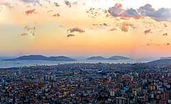
Living in Kartal today
Kartal is on the sea and there are ferries to Adalar (Princes' Islands) and to Yalova. But most people travel by road, it is easy to get from Kartal to both the D 100, the main road from Anatolia to the Bosphorus Bridge, and to the TEM, the large motorway which crosses the Bosphorus via the Fatih Sultan Mehmet Bridge. Also the coast road from Tuzla to Bostancı is another important route. The Sabiha Gökçen International Airport at Kurtköy, Pendik, is 15 minutes away. Finally, when the Marmaray project is completed it will be possible to reach the European side of Istanbul by a commuter rail system without interchange.
Kartal is the terminal station of Kartal - Kadıköy metro (M4). Haydarpaşa-Gebze Line for commuter trains also pass through Kartal.
With all these transport options Kartal is becoming heavily populated despite being far away from the centre of Istanbul. Luxury apartment complexes have been built on the coast, along with much more housing inland and this has attracted more shops and infrastructure.
There are a number of well-known private and state schools in the area, Maltepe University and Suleyman Sah University are the private universities of Kartal.
Housing is of good-quality in general. Building near the coast slowed after the 1999 earthquake, when people became very aware that a major fault line runs just off this coast. However, building on the high ground inland is proceeding apace and Kartal is projected to be a major urban and industrial area by the 2020s.
The park around Ayazma Fountain in Yakacik is a popular picnic spot for Kartal's people.
The Kartal Urban City Project
On 4 June 2007, the Greater Istanbul Municipality and the former mayor of Kartal announced that a new futuristic type urban city environment would be built in Kartal-Pendik. The city will be built on an area which is currently an abandoned industrial site. Upon completion, Kartal will be the new centre of Asian Istanbul. It is intended that the new city will be the world's first fully green "city". The plan includes a central business district, luxury residential developments, cultural facilities such as concert halls, museums, and theatres, and leisure locations including a marina and tourist hotels.[9]
Geography
Behind the coast the land rises sharply up to Yakacık Hill ("the balcony of Istanbul") and Aydos, on these hills the land is fertile and has a mild climate.
The coast of Kartal has sandy and clay soils, whereas the northern part of the district is mostly silica. On the Yakacık Hill, there are limestone and quartz deposits.
- Waters: The streams of Paşaköy, Kavaklıdere and Fındıklı feed the reservoir behind the Ömerli Dam.
Religion
The major population of today's Kartal are Muslims. Kartal Cemevi is one of the several Alevi temples in Istanbul. Kartal Surp Nişan Armenian Orthodox Church (Holy Cross Armenian Church) is an Armenian Church[10] located on the downtown of Kartal. Muhammad Maarifi Mosque which is also in Kartal has the mausoleum of a Maarifi Islamic order founder. There are seventy mosques within the district.[11]
Recreation
A part of the Kartal Park was developed in July 2018 as a "mist" park" featuring articial mist, colorful lisght effects and classical music attracting local residents and mainly children during the jot summer days.[13]
Sister towns


See also
- List of districts of Istanbul
- 9 March 2004, attack on Istanbul restaurant
References
- "Area of regions (including lakes), km²". Regional Statistics Database. Turkish Statistical Institute. 2002. Retrieved 5 March 2013.
- "Population of province/district centers and towns/villages by districts - 2012". Address Based Population Registration System (ABPRS) Database. Turkish Statistical Institute. Retrieved 27 February 2013.
- "Kartal İlçe Tarihi" (in Turkish). Kartal Kaymakamlığı. Archived from the original on 11 October 2012. Retrieved 7 September 2012.
- "History of Kartal". Kartal Municipality. Retrieved 7 September 2012.
- Kemal Karpat (1985), Ottoman Population, 1830-1914, Demographic and Social Characteristics, The University of Wisconsin Press, p. 138-139
- "Türkiye Büyük Millet Meclisi Genel Kurul Tutanağı 20. Dönem 3. Yasama Yılı 115. Birleşim" (in Turkish). TCBMM. 3 July 1998. Retrieved 13 September 2012.
- "Kartal Belediyesi 2010 Faaliyet Raporu" (PDF). Kartal Municipality. Retrieved 3 December 2012.
- "Tarihi eserler günışığına çıkıyor". CNN Türk. Archived from the original on 21 January 2013. Retrieved 3 December 2012.
- Zaha Hadid Architects Kartal - Pendik Masterplan Archived 13 May 2008 at the Wayback Machine.
- T.C. Başbakanlık Vakıflar Genel Müdürlüğü Archived 24 July 2012 at the Wayback Machine.
- Kartal Municipality Official Site - Worship.
- "2012 Yaz Tarifesi" (in Turkish). Prenstur. Archived from the original on 7 September 2013. Retrieved 7 September 2012.
- "İstanbul'da çocuklara 'Sis Parkı' eğlencesi". Anadolu Agancy (in Turkish). 20 July 2018. Retrieved 26 July 2018.
External links
| Wikimedia Commons has media related to Kartal (Istanbul). |