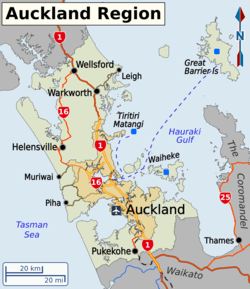
Auckland Region
The Auckland Region (Māori: Tāmaki Makaurau) is one of the sixteen regions of New Zealand, named for the city of Auckland, the country's largest urban area. The region encompasses the Auckland metropolitan area, smaller towns, rural areas, and the islands of the Hauraki Gulf. Containing 33 percent of the nation's residents,[1] it has by far the largest population and economy of any region of New Zealand, but the second-smallest land area.
| Auckland Region | |
| Country | |
 | |
| Regional council | |
|---|---|
| Name: | Auckland Council |
| Mayor: | Phil Goff |
| Population: | 1,642,800 (June 2019)[1] |
| Land area: | 4,894 km2 (1,890 sq mi)[2] |
| HDI: | 0.935[3] very high · 2nd |
| Website: | AucklandCouncil.govt.nz |
| Cities and towns | |
On 1 November 2010, the Auckland Region became a unitary authority administered by the Auckland Council, replacing the previous regional council and seven local councils. In the process, an area in its southeastern corner was transferred to the neighbouring Waikato region.
Geography
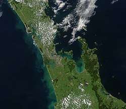
On the mainland, the region extends from the mouth of the Kaipara Harbour in the north across the southern stretches of the Northland Peninsula, past the Waitākere Ranges and the isthmus of Auckland and across the low-lying land surrounding the Manukau Harbour. The region ends within a few kilometres of the mouth of the Waikato River.[4] It is bordered in the north by the Northland Region, and in the south by the Waikato region. It also includes the islands of the Hauraki Gulf.
The Hunua Ranges and the adjacent coastline along the Firth of Thames were part of the region until the Auckland Council was formed in late 2010, when they were transferred to the neighbouring Waikato Region.
In land area it is smaller than all the other regions and unitary authorities except Nelson. Its highest point is the summit of Little Barrier Island, at 722 metres.
Demographics
| Historical population | ||
|---|---|---|
| Year | Pop. | ±% p.a. |
| 1991 | 943,773 | — |
| 1996 | 1,068,660 | +2.52% |
| 2001 | 1,158,891 | +1.63% |
| 2006 | 1,304,958 | +2.40% |
| 2013 | 1,415,550 | +1.17% |
| 2018 | 1,571,718 | +2.12% |
| Source: [5][6] | ||
Auckland Region had a population of 1,571,718 at the 2018 New Zealand census, an increase of 156,168 people (11.0%) since the 2013 census, and an increase of 266,760 people (20.4%) since the 2006 census. There were 496,458 households. There were 776,979 males and 794,742 females, giving a sex ratio of 0.98 males per female. Of the total population, 313,839 people (20.0%) were aged up to 15 years, 357,522 (22.7%) were 15 to 29, 711,186 (45.2%) were 30 to 64, and 189,177 (12.0%) were 65 or older. Figures may not add up to the total due to rounding.
Ethnicities were 53.5% European, 11.5% Māori, 15.5% Pacific peoples, 28.2% Asian, and 3.3% other ethnicities. People may identify with more than one ethnicity.
The percentage of people born overseas was 41.0, compared with 27.1% nationally.
Although some people objected to giving their religion, 42.6% had no religion, 38.4% were Christian, and 13.5% had other religions.
Of those at least 15 years old, 360,954 (28.7%) people had a bachelor or higher degree, and 168,276 (13.4%) people had no formal qualifications. The median income was $34,400. The employment status of those at least 15 was that 652,797 (51.9%) people were employed full-time, 171,738 (13.7%) were part-time, and 51,561 (4.1%) were unemployed.[6]
Towns and cities
The eponymous city of Auckland has a population of 1,467,800, making up 89.3% of the region's population.
Other urban areas in the Auckland region include:
- Hibiscus Coast (52,400)
- Pukekohe (24,300)
- Waiuku (9,660)
- Waiheke West (8,680)
- Beachlands-Pine Harbour (5,870)
- Warkworth (5,320)
- Snells Beach (3,540)
- Helensville (3,150)
- Kumeū-Huapai (2,670)
- Maraetai (2,290)
- Wellsford (2,120)
- Riverhead (2,010)
- Clarks Beach (1,480)
- Waimauku (1,370)
- Muriwai (1,330)
See also
References
- "Subnational Population Estimates: At 30 June 2019". Statistics New Zealand. 22 October 2019. Retrieved 11 January 2020.
- "Auckland Council Draft Annual Plan 2011/2012 - Volume 1: Our Region" (PDF). Auckland Council. p. 2. Retrieved 9 March 2011.
- "Sub-national HDI - Area Database - Global Data Lab". hdi.globaldatalab.org. Retrieved 13 September 2018.
- McClure, Margaret (6 December 2007). "Auckland region - Landforms'". Te Ara: The Encyclopedia of New Zealand. Retrieved 1 June 2019.
- "2001 Census: Regional summary". archive.stats.govt.nz. Retrieved 28 April 2020.
- "Statistical area 1 dataset for 2018 Census". Statistics New Zealand. March 2020. Auckland Region (02). 2018 Census place summary: Auckland Region
External links


| North Island | ||
|---|---|---|
| South Island | ||
* Governed by a unitary authority rather than a regional council | ||