Mangalagiri
Mangalagiri is a town in Guntur district situated between the twin cities of Vijayawada and Guntur of the Indian state of Andhra Pradesh. The town is the headquarters of Mangalagiri mandal under Guntur revenue division.[5][6] It is a major suburb of the cities of Vijayawada and Guntur. It also forms a part of the Andhra Pradesh Capital Region. It is situated on National Highway 16 between Vijayawada and Guntur.[7] The town was known to have existed since 225 B.C..[8] It is also a part of Andhra Pradesh Capital Region with a population of 73,613.
Mangalagiri Totadri | |
|---|---|
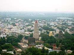 View of Mangalagiri town | |
.svg.png) Mangalagiri | |
| Coordinates: 16.43°N 80.55°E | |
| Country | India |
| State | Andhra Pradesh |
| Region | Coastal Andhra |
| District | Guntur |
| Mandal | Mangalagiri |
| Established | 225 B.C. |
| Named for | The Auspicious Hill |
| Government | |
| • Type | Municipal council |
| • Body | Mangalagiri Municipality APCRDA |
| • MLA | Alla Rama Krishna Reddy (YSR Congress Party) |
| • Municipal commissioner | K. Hema Malini |
| Area | |
| • Total | 17.53 km2 (6.77 sq mi) |
| Elevation | 43 m (141 ft) |
| Population | |
| • Total | 73,613 |
| Languages | |
| • Official language | Telugu |
| Time zone | UTC+5:30 (IST) |
| PIN | 522503 |
| Telephone code | 91–8645 |
| Vehicle registration | AP–07 (former) AP-39 (new) |
| Lok Sabha constituency | Guntur |
| Assembly constituency | Mangalagiri |
| Website | mangalagiri |
Etymology
Mangalagiri translates to The Auspicious Hill (Mangala = Auspicious, Giri = Hill) in the local language. It was derived from the name Totadri.[7] During Vijayanagara Kingdom, it was also known as Mangala Nilayam.[8][9]
History
It is dated to 1520 and mentions the capture of Kondavidu by Timmarasu, general of Krishna Deva Raya, in 1515 from the Gajapati rulers of Kalinga (ancient Odisha). Another stone near the temple of Garudalvar has inscriptions on four sides recording grants in the reign of Sadasiva Raya of Vijayanagara Empire 1538. The lofty gopuram in the temple at the foot of the hill was erected by Raja Vasireddy Venkatadri Nayudu in 1807–1809, and in terms of sculpture and architecture this temple stands to be an ultimate testament for the ancient vishwakarma sthapathis in planning and sculpting these temples.[10][11]
Mangalagiri was under the control of Golkonda Nawabs for a long period. It was plundered in 1780 by Hyder Jung but could not be conquered. In 1816, a gang of Pindaris again looted the place. It slowly recovered from these two attacks during the time of Raja Vasireddy Venkatadri Nayudu who ruled the place from Amaravati. There is a big koneru (tank) in the center of the place which went dry in 1882. As many as 9,840 guns and 44 bullets which might have been related to Pindaris have been found here after the Pindaris looted this place.The picturesque hill was visited by the great Sri Krishna Deva Raya.[12]
In the 1970s there was huge water scarcity in Mangalagiri. Goli Gopala Rao, the then municipal chairman of Mangalagiri, brought water to the town through water pipelines and he was called "Apara Baghiratha" due to his services to the public.
Geography
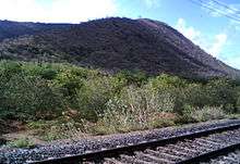
Mangalagiri is located at 16.43°N 80.55°E.[13] It has an average elevation of 29.08 m (95.4 ft).It is located 26 kilometres (16.2 mi) north east of the district headquarters, Guntur, and just 10 kilometres (23 mi) south west of Vijayawada and also 30 kilometers ((18.7 mi)) to the south of Tenali by road. It lies on hilly terrain. It falls under Seismic Zone 3.
Climate
The climate in Mangalagiri is tropical. The hottest months are from March–May and the coolest months from December–January. It receives south-west in the months of July–October and north–east monsoons in mid December. The average annual rainfall is 50–60 cm. The summer temperatures varies from 44–46 °C and the winter temperatures from 22–23 °C.[14]
Demographics

As of 2011 Census of India, the town had a population of 73,613 with 19,137 households. The total population constitute, 36,532 males and 37,081 —a sex ratio of 1015 females per 1000 males. 7,706 children are in the age group of 0–6 years, of which 3,894 are boys and 3,812 are girls —a ratio of 979 per 1000. The average literacy rate stands at 76.16% with 50,197 literates, significantly higher than the state average of 67.41%.[5][15]
Governance

Civic Administration
Mangalagiri Municipality is the civic body of the town, which oversees the civic needs like, water supply, sewage, garbage collection etc. It was establishment in the year 1969 and has an extent of 17.53 km2 (6.77 sq mi) with 32 election wards.[1] The composition of the municipality is of two types, one is Elected Wing, headed by Municipal Council and the second is Executive Wing, headed by Municipal commissioner.[16] In 2015, the municipality received Green Leaf Awards 2015 in the category of Best Municipality, which was organized by NGO Sukuki Exnora.[17] Mangalagiri municipality and its out growths of Navuluru and Atmakur are a part of Vijayawada urban agglomeration.[18]
Politics
Mangalagiri town is a part of Mangalagiri assembly constituency for Andhra Pradesh Legislative Assembly. Alla Rama Krishna Reddy is the present MLA of the constituency representing YSRCP.[19] The assembly segment is in turn a part of Guntur lok sabha constituency, which was won by Galla Jayadev.[20][21]
Economy
The production of handcrafted dyed fabric is the major occupation of the town, which is as old as 500 years.[22][23] Mangalagiri Sarees and Fabrics was registered as one of the geographical indication from Andhra Pradesh.[24]
Tourism

Lakshmi Naramisha Temple is the abode of Lord Vishnu, who manifested himself as Thotadri, is present in Mangalagiri. There are three Narasimha Swamy temples.[25] Undavalli caves, located near Mangalagiri, a specimen of Indian rock-cut architecture. The historic caves are located at the top of the hills overlooking the Krishna River, built during the 4th-5th century. Dedicated to Ananta Padmanabha Swamy and Narasimha Swamy, Undavalli Cave Temples are associated with the Vishnukundina kings.[26] Hinkar Thirtha Jain Temple, located in Namburu is the largest Jain temple in the region, visited by many Jains, from different parts of the state.[27]
Transport
Mangalagiri is located on NH 16 that connects Kolkata and Chennai.[7] The town has a total road length of 109.30 km (67.92 mi).[28] The Tenali-Mangalagiri road is a part of the core road network of the district, that connects the town with the city of Tenali.[29]
Mangalagiri bus station is owned and operated by Andhra Pradesh State Road Transport Corporation.[30] The station is also equipped with a bus depot for operation and maintenance of buses.[31][32] Mangalagiri railway station situated on the Vijayawada-Guntur Main Line, administered under the jurisdiction of Guntur division of South Central Railway zone.[33]
Vijayawada International Airport at Gannavaram attracts the air commuters from this town.
Also there is a proposal of making Mangalagiri railway station as Mangalagiri Junction by connecting the town with the city Tenali railway station in order to make the transportation from Guntur, Tenali, Amaravathi, Vijayawada cities easier.
Education
C.K High school and C.K.Junior college & V.T.J.M &I.V.T.R degree college first school and college respectively. The primary and secondary school education is imparted by government, aided and private schools, under the School Education Department of the state.[34][35] The medium of instruction followed by different schools are English, Telugu and Urdu.
The town is having many schools, colleges VIT-AP University, SRM AP University, etc. AIIMS for the state of Andhra Pradesh was sanctioned and is decided to set up in the town.[36]
Sports
Mangalagiri International Cricket Stadium is under construction in Mangalagiri[37] at a distance of 2 km from the city.
See also
References
- "Municipalities, Municipal Corporations & UDAs" (PDF). Directorate of Town and Country Planning. Government of Andhra Pradesh. Archived from the original (PDF) on 28 January 2016. Retrieved 29 January 2016.
- "Elevation for Mangalagiri". Veloroutes. Retrieved 1 August 2014.
- "Census 2011". The Registrar General & Census Commissioner, India. Retrieved 1 August 2014.
- "Statistical Abstract of Andhra Pradesh, 2015" (PDF). Directorate of Economics & Statistics. Government of Andhra Pradesh. p. 43. Archived from the original (PDF) on 14 July 2019. Retrieved 26 April 2019.
- "District Census Handbook – Guntur" (PDF). Census of India. pp. 14–15. Retrieved 24 August 2015.
- "Guntur District Mandals" (PDF). Census of India. pp. 64, 107. Retrieved 19 January 2015.
- "Mangalagiri Municipality". Commissioner & Director of Municipal Administration. Municipal Administration & Urban Development Department, Govt. of Andhra Pradesh. Retrieved 19 November 2014.
- "Vijaya Nagara Kingdom Founders from Mangalagiri". mangalagiri.net. Retrieved 12 April 2015.
- "Mangalagiri – The Auspicious Hill". National Informatics Centre. Retrieved 3 August 2014.
- "Mangalagiri".
- "Mangalagiri" (PDF).
- "Mangalagiri - The Auspicious Hill".
- Falling Rain Genomics, Inc – Mangalagiri
- ":: MANGALAGIRI Municipality". cdma.ap.gov.in. Retrieved 3 April 2016.
- "Literacy of AP (Census 2011)" (PDF). Official Portal of Andhra Pradesh Government. p. 43. Archived from the original (PDF) on 14 July 2014. Retrieved 5 September 2014.
- "Composition of the Municipality". Commissioner & Director of Municipal Administration. Municipal Administration & Urban Development Department, Govt. of Andhra Pradesh. Retrieved 4 August 2014.
- "TS and AP NGOs sweep Green Leaf awards". The Hans India. 8 June 2015. Retrieved 13 March 2016.
- "Name of Urban Agglomeration and its State constituent Units-2011" (PDF). Census of India. p. 23. Retrieved 21 September 2015.
- "MLA". AP State Portal. Archived from the original on 8 October 2014. Retrieved 13 October 2014.
- "Delimitation of Parliamentary and Assembly Constituencies Order, 2008" (pdf). Election Commission of India. p. 22,31. Retrieved 11 October 2014.
- "MP (Lok Sabha)". Government of AP. Archived from the original on 21 November 2016. Retrieved 4 May 2015.
- "The Exquisite Sarees of Mangalagiri". AP Tourism Blog. Archived from the original on 1 February 2016. Retrieved 25 January 2016.
- Rao, R.V. (1978). Rural Industrialisation in India: The Changing Profile. Concept Publishing Company. p. 54. ISBN 978-81-7022-017-6. Retrieved 28 May 2015.
- "State Wise Registration Details of G.I Applications" (PDF). Geographical Indication Registry. p. 6. Archived from the original (PDF) on 1 February 2016. Retrieved 28 January 2016.
- "Mangalagiri Temple: Mangalagiri – The Auspicious Hill". Guntur District Government Of Andhra Pradesh. Retrieved 12 December 2014.
- "Tourist places". mangalagiri website. Retrieved 13 July 2014.
- "Hinkar Thirtha (Jain Temple)" (PDF). vijayawadaonline. Retrieved 13 July 2014.
- "Details of Roads in each ULB of Andhra Pradesh". Municipal Administration and Urban Development Department. Archived from the original on 1 August 2016. Retrieved 27 June 2016.
- ":: APRDC ::". Andhra Pradesh Road Development Corporation. Roads and Buildings Department. Archived from the original on 9 November 2016. Retrieved 9 November 2016.
- "Bus Stations in Districts". Andhra Pradesh State Road Transport Corporation. Archived from the original on 22 March 2016. Retrieved 8 March 2016.
- "Depot Name". APSRTC. Archived from the original on 9 March 2016. Retrieved 15 March 2016.
- Susarla, Ramesh (11 September 2006). "Ponnur RTC depot on way out?". The Hindu. Retrieved 15 March 2016.
- "Mangalagiri railway station". India Rail Info. Retrieved 11 May 2015.
- "School Education Department" (PDF). School Education Department, Government of Andhra Pradesh. Archived from the original (PDF) on 27 December 2015. Retrieved 7 November 2016.
- "The Department of School Education - Official AP State Government Portal | AP State Portal". www.ap.gov.in. Archived from the original on 7 November 2016. Retrieved 7 November 2016.
- Reporter, Staff (21 December 2015). "AIIMS at Mangalagiri in three years: Nadda". The Hindu. Retrieved 22 September 2016.
- "Construction company". The Hindu. Retrieved 11 May 2014.