Nha Trang
Nha Trang (/ˌnjɑːˈtʃæŋ/; Vietnamese: [ɲaː˧ ʈaːŋ˧] (![]()
Nha Trang Thành phố Nha Trang | |
|---|---|
| Nha Trang City | |
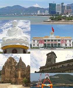 Clockwise, from top: Nha Trang Coastline, City Hall, Christ the King Cathedral, Vinpearl Cable Car, Po Nagar Tower, Long Sơn Pagoda | |
 Seal | |
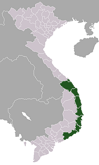
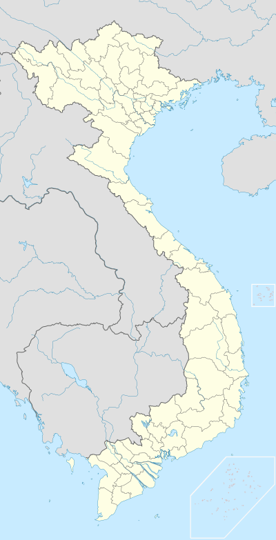 Nha Trang Location in Vietnam | |
| Coordinates: 12°15′N 109°11′E | |
| Country | |
| Admin. division | Khánh Hòa Province |
| Government | |
| • People's Committee President | Lê Hữu Thọ |
| • People's Committee Vice President 1 | Nguyễn Anh Tuấn |
| • People's Committee Vice President 2 | Lê Huy Toàn |
| • People's Committee Vice President 3 | Nguyễn Khắc Hà |
| Area | |
| • Total | 251 km2 (97 sq mi) |
| Population (2018) | |
| • Total | 535,000 |
| • Density | 1,675/km2 (4,340/sq mi) |
| Time zone | GMT + 7 |
| ZIP code | 625080 |
| Climate | Aw |
| Website | nhatrang.khanhhoa.gov.vn |

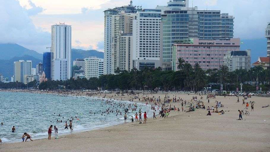
Nha Trang is well known for its beaches and scuba diving and has developed into a popular destination for international tourists, attracting large numbers of backpackers, as well as more affluent travelers on the south-east Asia circuit; it is already very popular with Vietnamese tourists, with Nha Trang Bay widely considered as among the world's most beautiful bays. Tourists are welcomed to participate in the Sea Festival, held biennially. Nha Trang was the site of the Miss Universe 2008 Pageant on July 14, 2008 and Miss Earth 2010 was held on December 4, 2010. It was also the site for the April 14, 2015 season 8 finale of Face Off. Nha Trang was approved to host the 2016 Asian Beach Games.
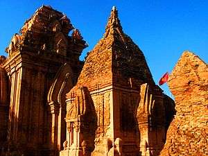
Historically, the city was known as Kauthara under rule of the Kingdom of Champa. The city is still home to the famous Po Nagar Tower built by the Champa. Being a coastal city, Nha Trang is a centre for marine science based at the Nha Trang Oceanography Institute. The Hon Mun marine protected area is one of four first marine protected areas in the world admitted by the IUCN.
Etymology
According to some researchers, the name Nha Trang derives from a Vietnamese spelling of the Cham language name of the site Ya Trang (literally "Reed River"), the name of the Cai River as referred to by the Cham people. From the name of this river, the name was adopted to call what is now Nha Trang, which was officially made Vietnam's territory in 1698. Ya Drang is a common Cham and Montagnard place name, same as Ia Drang Valley.
As far as the recorded naming of Nha Trang is concerned, in Toàn tập Thiên Nam Tứ Chí Lộ Đồ Thư, a geographical book written by a Vietnamese scholar with the family of Đỗ Bá in the second half of the 18th century, the name Nha Trang Môn ("Nha Trang gate") was mentioned.[2] In another map dating to the 17th century, known as Giáp Ngọ Niên Bình Nam Đồ by a noble called Đoan Quận công Bùi Thế Đạt, the name Nha Trang Hải môn (Nha Trang Sea Gate) was also cited.[2] In Vietnamese recorded historic bibliographies, these books are perhaps the earliest ones that mentioned this place name.
In a work by Lê Quý Đôn called Phủ biên tạp lục (1776), many Nha Trang-related names were mentioned, such as đầm Nha Trang, dinh Nha Trang, nguồn Nha Trang, and đèo Nha Trang.
History
Kauthara, also translated as ancient clam, is a constituent state of the empire-leading kingdom and its ruling area is located in the area from today's Fu An province to Cam Ranh. Yanpunagara, the capital of Yangpu, occupies the faith of a man and is deeply influenced by religions such as Brahmanism and Buddhism. However, in addition to that, the gods who formerly occupied ruled the indigenous faith in the motherland, such as Çri Maladakuthara (釋利摩落陀古笪羅) in the ancient Gur'an region in the south, are one of those who can preserve the old God Most of the old gods who dominated the motherland were replaced by brahmanist gods such as the goddess Yan Pu Nagara (楊浦那竭羅) [3] and the Bhagavati (妻婆伽婆底), Replaced, located in Nha Trang near today. Bhagavati is mixed with Yan Pu Nagara, a goddess in the local faith, which is quite revered by the people and has dedicated ancestral temples to enshrine it.[4]
From 1653 to the 19th century, Nha Trang was a deserted area rich in wildlife (animals like tigers) and was a part of Hà Bạc, Vĩnh Xương County, Diên Khánh Province. After just two decades in the early 20th century, Nha Trang underwent a rapid change. On August 30, 1924, the Governor-General of French Indochina decreed Nha Trang as a townlet (urban centre).[5] Nha Trang Townlet was established from the ancient villages of Xương Huân, Phương Câu, Vạn Thạnh, Phương Sài, and Phước Hải.
During French Indochina, Nha Trang was seen as de facto capital of Khánh Hòa Province. The colonial administration offices (like Envoy Office, Commanding Office, Trade Office, Post Office) were situated in Nha Trang. Local royal offices like Province Chief, Provincial Judge, Military Commander are in Diên Khánh city (a walled military city 10 km south-west of Nha Trang).
On 7 May 1937, the Governor-General of French Indochina by another decree upgraded Nha Trang Townlet to town.[6] At this time, Nha Trang Town had five wards based on the ancient villages merged to make the town: Xương Huân, Phương Câu, Vạn Thạnh, Phương Sài, and Phước Hải.
On 27 January 1958, the president of the Republic of Vietnam, Ngô Đình Diệm by Decree 18-BNV abrogated the town status of Nha Trang and divided Nha Trang into two rural communes: Nha Trang Đông (Eastern Nha Trang) and Nha Trang Tây (Western Nha Trang), under the administration of Vĩnh Xương County.
During the late 1960s, the U.S. Army's First Field Force, Vietnam (1FFV)was headquartered in Nha Trang. 1FFV was a corps-level major subordinate command of the U.S. Army Military Assistance Command, Vietnam (MACV).
On 22 October 1970, the government of the Republic of Vietnam by Decree 132-SL/NV reestablished Nha Trang Town on the ground of Nha Trang Đông and Nha Trang Tây and other rural communes. Following that establishment, the government by Decree 357-ĐUHC/NC/NĐ dated 5 June 1971 divided Nha Trang into 11 urban zones.
On 2 April 1975, communist (Viet Cong/PRG/VPA) forces captured the city. On 4 April 1975, Khánh Hòa Military Commission (Ủy ban Quân quản Khánh Hòa) divided Nha Trang into three administrative districts: District 1, District 2 and Vĩnh Xương District. In September 1975, the districts were merged to become one entity, the town of Nha Trang.
On 30 March 1977, the Council of the Government (now the cabinet) of the Socialist Republic of Vietnam by Decision 391-CP/QĐ upgraded Nha Trang to city status, a county-level city under the administration of Phú Khánh Province (a province created by merger of now Phú Yên Province and Khánh Hòa Province). Seven communes of former Vĩnh Xương County, namely Vĩnh Thái, Vĩnh Ngọc, Vĩnh Hiệp, Vĩnh Lương, Vĩnh Trung, Vĩnh Thạnh, Vĩnh Phương was split from Khánh Xương County to become Nha Trang City territory.
On 27 March 1978, the provincial government by Decision 54-BT founded Phước Đồng Commune under Nha Trang City.
On 1 July 1989, Khanh Hoa was split from Phu Khanh Province to become Khánh Hòa Province as it was before, Nha Trang was made the capital of Khánh Hòa Province. On April 22, 1999, the prime minister by Decision 106/1999 recognized Nha Trang City the second class municipal city. On April 22, 2009, the prime minister Nguyễn Tấn Dũng recognized Nha Trang City at the first class municipal city.
Geography
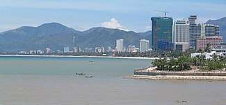
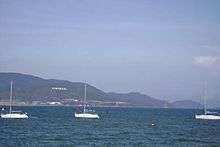
Nha Trang city has a metropolitan area of 251 km² and population of about 500,000. It borders Ninh Hòa town in the north, Cam Ranh city in the south, Diên Khánh town in the west and the East Sea to the east. The city is on the beautiful Nha Trang Bay, which was chosen by Travel + Leisure in two succeeding years as one of 29 most beautiful bays in the world. Nha Trang is surrounded on all three sides by mountains and a large island and four smaller ones on the fourth side (in the ocean directly in front of the city's main area), blocking major storms from potentially damaging the city.
Climate
Nha Trang has a tropical savanna climate (Köppen climate classification: As) with a lengthy dry season from January to August and a shorter wet season from September to December, when 1,029 millimetres (41 in) of the city's total annual rainfall of 1,361 millimetres (54 in) is received from the north-east monsoon.[7][8] During the wet season extremely heavy rainfall from typhoons is not uncommon,[9] though the city is shielded from the worst winds.
| Climate data for Nha Trang | |||||||||||||
|---|---|---|---|---|---|---|---|---|---|---|---|---|---|
| Month | Jan | Feb | Mar | Apr | May | Jun | Jul | Aug | Sep | Oct | Nov | Dec | Year |
| Record high °C (°F) | 31.9 (89.4) |
33.3 (91.9) |
34.2 (93.6) |
35.9 (96.6) |
38.5 (101.3) |
39.5 (103.1) |
39.0 (102.2) |
39.5 (103.1) |
38.3 (100.9) |
34.8 (94.6) |
34.3 (93.7) |
32.8 (91.0) |
39.5 (103.1) |
| Average high °C (°F) | 26.9 (80.4) |
27.7 (81.9) |
29.3 (84.7) |
31.0 (87.8) |
32.3 (90.1) |
32.5 (90.5) |
32.4 (90.3) |
32.5 (90.5) |
31.5 (88.7) |
29.7 (85.5) |
28.2 (82.8) |
26.9 (80.4) |
30.1 (86.2) |
| Daily mean °C (°F) | 23.9 (75.0) |
24.5 (76.1) |
25.7 (78.3) |
27.3 (81.1) |
28.4 (83.1) |
28.6 (83.5) |
28.4 (83.1) |
28.4 (83.1) |
27.6 (81.7) |
26.6 (79.9) |
25.6 (78.1) |
24.4 (75.9) |
26.6 (79.9) |
| Average low °C (°F) | 21.3 (70.3) |
21.8 (71.2) |
22.9 (73.2) |
24.6 (76.3) |
25.5 (77.9) |
25.6 (78.1) |
25.4 (77.7) |
25.4 (77.7) |
24.7 (76.5) |
24.0 (75.2) |
23.3 (73.9) |
22.0 (71.6) |
23.9 (75.0) |
| Record low °C (°F) | 14.6 (58.3) |
14.6 (58.3) |
16.4 (61.5) |
19.4 (66.9) |
19.7 (67.5) |
19.8 (67.6) |
20.6 (69.1) |
21.5 (70.7) |
21.3 (70.3) |
18.8 (65.8) |
16.9 (62.4) |
15.1 (59.2) |
14.6 (58.3) |
| Average rainfall mm (inches) | 38 (1.5) |
16 (0.6) |
31 (1.2) |
35 (1.4) |
70 (2.8) |
59 (2.3) |
36 (1.4) |
50 (2.0) |
159 (6.3) |
302 (11.9) |
332 (13.1) |
153 (6.0) |
1,280 (50.4) |
| Average rainy days | 7.8 | 4.0 | 3.3 | 4.3 | 8.5 | 9.2 | 8.4 | 9.6 | 15.2 | 17.7 | 17.6 | 14.0 | 119.5 |
| Average relative humidity (%) | 78.0 | 78.8 | 79.7 | 80.5 | 79.3 | 77.8 | 77.2 | 77.4 | 80.4 | 83.2 | 81.8 | 79.5 | 79.5 |
| Mean monthly sunshine hours | 185 | 208 | 261 | 258 | 255 | 230 | 242 | 233 | 202 | 183 | 142 | 142 | 2,540 |
| Source: Vietnam Institute for Building Science and Technology[10] | |||||||||||||
Administrative divisions


Nha Trang is subdivided into 27 wards and communes, of which 20 are urban wards: Vĩnh Hải, Vĩnh Phước, Vĩnh Thọ, Xương Huân, Vạn Thắng, Vạn Thạnh, Phương Sài, Phương Sơn, Ngọc Hiệp, Phước Hòa, Phước Tân, Phước Tiến, Phước Hải, Lộc Thọ, Tân Lập, Vĩnh Nguyên, Vĩnh Trường, Phước Long (founded in November 1998), Vĩnh Hòa (founded in April 2002); and 8 suburban communes: Vĩnh Phương, Vĩnh Trung, Vĩnh Thạnh, Vĩnh Thái, Vĩnh Hiệp, Vĩnh Ngọc, Vĩnh Lương, and Phước Đồng. Since 1998, due to the high pace of urbanization, many urban planned zones have been built: Hòn Rớ, Bắc Việt, Thánh Gia, Đường Đệ, and Nam Hòn Khô.
Education
Nha Trang is home to the multidisciplinary Nha Trang University (formerly Nha Trang Fishery University); the Naval and Aviation Academy; a teacher's training college; Khanh Hoa University, as well as the Nha Trang Oceanography Institute a unique institute of oceanography in Vietnam and the Pasteur Institute of Nha Trang, one of the many famous Pasteur Institutes.
Nha Trang Pasteur Institute
The French-Swiss bacteriologist Alexandre Yersin, discoverer of the Yersinia pestis bacterium lived in Nha Trang for 50 years and was affectionately known as Ông Năm. He established the Indochinese Pasteur Institute (now known as the Pasteur Institute of Nha Trang), devoted to researching the bubonic plague. Yersin died in Nha Trang on 1 March 1943. A street in the city is named after him, and a shrine has been built over his tomb. There is a Yersin Museum dedicated to his achievements.
Economy
Nha Trang's economy relies largely on tourism. In the suburban areas around the city, the shipbuilding industry has developed and contributed significantly to the local economy. Fishery and services are also important to the city. Khánh Hòa Province in general and Nha Trang is particular are among the largest contributors to Vietnam's annual budget revenues. Lobster farming on the sea is an important industry for the people living in suburb areas.
To the south of the city, by Cam Ranh Bay, several industrial parks are under construction and have been partly available for investors. Once the construction of the deep-water port on Vân Phong Bay has been completed, this area will become the third important economic zone in the province (besides Nha Trang and Cam Ranh).
Tourism
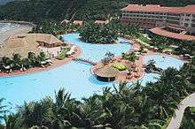
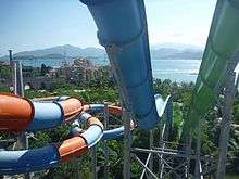
Nha Trang is one of the most important tourist hubs of Vietnam, thanks to its beaches with fine and clean sand and the clear ocean water with mild temperatures all year round. There are several resorts — such as Vinpearl, Diamond Bay and Ana Mandara — and amusement and water parks, in the city and on islands off the coast. The possibly most beautiful street of Nha Trang is Tran Phu Street along the seaside, sometimes referred to as the Pacific Coast Highway of Vietnam.
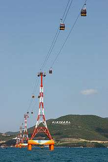
Lying off Nha Trang is the Hon Tre Island (Bamboo Island), with a major resort operated by the Vinpearl Group. The Vinpearl Cable Car, a gondola lift system, links the mainland to the five-star resort and theme park on Hon Tre Island.
Nha Trang is a stopover for annual yacht races starting in Hong Kong. In recent years, the city has welcomed many five-star sea cruises. In addition to sailboat racing, Nha Trang provides a rich variety of tourist activities for visitors. Island hopping, scuba diving, water sports and other sporting activities can be enjoyed. The Nha Trang Tourist Information Center (a non-governmental organisation), located near the Cho Dam Market has been set up to provide information for visitors.[11]
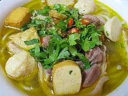
The local cuisine is most famous for fresh seafood and barbecued pork rolled in rice paper. The area's bird's nest soup is deemed one of the best in Vietnam. Bird's nests are collected in the wild, on bird farms on the islands off the coast and even in some houses in the inner city. The farmed bird in question belongs to the swiftlet group, popularly referred to as yến hàng (Aerodramus fuciphagus and A. germani).
Tourist attractions

Scuba diving and kite boarding are available, as are catamaran sailboats. Winds are steady.
- Alexandre Yersin Museum
- Pasteur Institute of Nha Trang
- Nha Trang Oceanography Institute, the largest of its kind in Indochina where thousands of oceanic life samples, exhibits are on display. It is home to the largest oceanic library in Vietnam.
- Chánh Tọa Church (or Mountain Church)
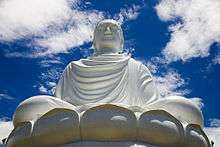
- Long Son Pagoda, and its statue of Gautama Buddha.
- Tong Lam Lo Son Pagoda, and its statue of Amitabha Buddha.
- Magical Mystery Tour Nha Trang
- Boat tour on Cai River, visiting islands off the coast and Ba Hồ Waterfall
- Palace of Emperor Bảo Đại
- Thap Ba Hot Spring (Lady Tower hot spring)
- Nha Phu Lagoon
- Hoa Lan Stream (Orchid Flower stream)
- Monkey Island
- Sạn Beach
- Nha Trang Booze Cruise (all-you-can-drink party boat)
- Hòn Tằm Island (Silkworm island)
- Hòn Mun Island (Ebony island)
- Hòn Con Sẻ Tre Island (Bamboo Sparrow island)
- Hòn Ông Island
- Đảo Yến Island (Swiftlet island)
- Hòn Tre Island (Bamboo island)
- Suối Đổ Stream
- Suối Tiên Stream (Fairy stream)
- Hòn Bà Mountain
- Cai River Minigolf & Restaurant & Marina
- Yangbay Waterfall
- Tháp Bà Pô Nagar Nha Trang (a Champa Tower)
- Chùa Long Sơn (Long Son Pagoda, literally "The Dragon Mountain Pagoda" — or White Buddha Pagoda)
- Trí Nguyên Aquarium (an aquarium where hundreds of rare oceanic species are fed)
- Vinpearl Cable Car
Culture
Cuisine
Local culinary specialities that attract people are bánh canh chả cá (bánh canh with fish paddies), bún cá sứa (rice vermicelli with jelly fish) and bánh xèo mực (squid pancakes).
Nightlife
The nightlife is known as superior to other coastal towns such as Mui Ne and Vũng Tàu It is usually busiest around the Vietnamese New Year and can be worth visiting most of the year, with the possible exception of the rainy period (especially November).
Many tourists enjoy the Nha Trang River Cai boat ride (locally known as Song Cai, as "song" means "river" in the Vietnamese language).
Transportation
When Cam Ranh Bay used to be an important naval base, Nha Trang Airport was the main airport of the city. This airport was used by the United States Air Force and Republic of Vietnam Air Force during the Vietnam War. When part of Cam Ranh Bay was made an economic development zone by the Vietnamese government, Cam Ranh International Airport (also a military airport built by the United States during Vietnam War) was made the new civilian airport of the city. This airport is located by Cam Ranh Bay, 28 km (17 mi) south of the city and was (as of 2007) the fourth busiest airport in passenger traffic in Vietnam serving more than 683,000 passengers in 2008. As of 2016, the airport has domestic connections to Hanoi, Hồ Chí Minh City, Hải Phòng, Đà Nẵng, Vinh.
The city is next to the National Route 1A, the backbone north-south road of the country. The Reunification Railway crosses the city and stops at Nha Trang Railway Station. The construction work of Vân Phong Port, north of the city, a deep-water project capable of handling ships up to 100,000 tonnes, and with a capacity of 100 million tonnes of cargo per annum, is under progress by a consortium of Japanese corporations. The estimated investment capital for this port-city complex project is expected to reach US$15 billion.
Gallery
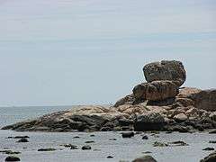 Hon Chong rocks
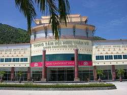 The official venue of Miss Universe 2008 pageant
 Nha Trang Bay
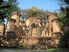 Another view at Po Nagar temple
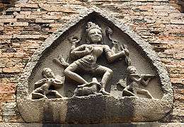 A Durga ornament
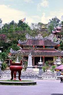 Long Son pagoda
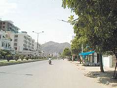 A typical street in Nha Trang City
 Bridges
 Oceanographic Institute
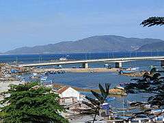 Another view
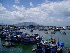 The fishing harbour
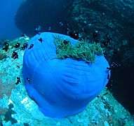 Sea anemone
Sister cities
See also
Notes
References
- "Mở rộng Nha Trang về phía tây (Nha Trang will be expanded to the west". Tuoi Tre Newspaper. 2012-09-27.
- Hồng Đức bản đồ, bản dịch của Bửu Cầm và cộng sự, Viện Khảo cổ Sài Gòn xuất bản 1962.
- 馬司培羅《占婆史》第一章《土地及人民》,臺灣商務印書館中譯本,6頁。
- 馬司培羅《占婆史》第一章《土地及人民》,臺灣商務印書館中譯本,4-5頁。
- According to J.O.I.C page 1689, a copy from French version kept as archives Monographical Department of Khanh Hoa Province Library.
- According to Official Gazette number 9 of 1937 by the French colonial government, kept as archive in Monographical Department of Khanh Hoa Library.
- Kottek, Markus; Grieser, Jürgen; Beck, Christoph; Rudolf, Bruno; Rubel, Franz (2006). "World Map of the Köppen-Geiger climate classification updated" (PDF). Meteorologische Zeitschrift. 15 (3): 259–263. Bibcode:2006MetZe..15..259K. doi:10.1127/0941-2948/2006/0130.
- Peel, M. C.; Finlayson B. L. & McMahon, T. A. (2007). "Updated world map of the Köppen–Geiger climate classification" (PDF). Hydrol. Earth Syst. Sci. 11 (5): 1633–1644. doi:10.5194/hess-11-1633-2007. ISSN 1027-5606.
- See More Variable Tropical Climates Have a Slower Demographic Growth
- "Vietnam Building Code Natural Physical & Climatic Data for Construction" (PDF) (in Vietnamese). Vietnam Institute for Building Science and Technology. Archived from the original (PDF) on 22 July 2018. Retrieved 23 July 2018.
- NhaTrang live info center
External links
| Wikimedia Commons has media related to Nha Trang. |
| Wikivoyage has a travel guide for Nha Trang. |
| Preceded by Auditorio Nacional Mexico City, Mexico |
Miss Universe Venue 2008 |
Succeeded by Atlantis Paradise Island Nassau, Bahamas |
| Preceded by Boracay Convention Center Boracay, Philippines |
Miss Earth Venue 2010 |
Succeeded by University of the Philippines Theater Quezon City, Philippines |
| ||||||||||||||||||||||||||||||||||
| Authority control |
|
|---|