Colebrook, Connecticut
Colebrook is a town in Litchfield County, Connecticut, United States. The population was 1,485 at the 2010 census.[2] Colebrook was named after Colebrooke in the English county of Devon; the reason is now unknown.[3]
Colebrook, Connecticut | |
|---|---|
 Colebrook town hall | |
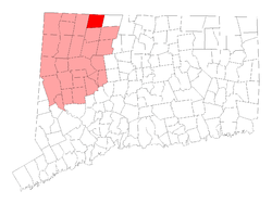 Location in Litchfield County, Connecticut | |
| Coordinates: 42°00′05″N 73°05′04″W | |
| Country | |
| U.S. state | |
| County | Litchfield |
| NECTA | Torrington |
| Region | Northwest Hills |
| Incorporated | 1779 |
| Government | |
| • Type | Selectman-town meeting |
| • First selectman | Thomas D. McKeon (R) |
| • Selectman | Christopher L. Johnstone (R) |
| • Selectman | Joseph J. Alciati, Sr. (D) |
| Area | |
| • Total | 32.9 sq mi (85.3 km2) |
| • Land | 31.5 sq mi (81.7 km2) |
| • Water | 1.4 sq mi (3.6 km2) |
| Elevation | 961 ft (293 m) |
| Population (2010)[1] | |
| • Total | 1,485 |
| • Density | 47/sq mi (18.2/km2) |
| Time zone | UTC-5 (Eastern) |
| • Summer (DST) | UTC-4 (Eastern) |
| ZIP code | 06021 |
| Area code(s) | 860 |
| FIPS code | 09-16050 |
| GNIS feature ID | 0213410 |
| Website | www |
Geography
Colebrook is in northeastern Litchfield County and is bounded to the east by Hartford County, Connecticut, and to the north by Berkshire and Hampden County in Massachusetts. According to the United States Census Bureau, the town has a total area of 32.9 square miles (85.3 km2), of which 31.5 square miles (81.7 km2) are land and 1.4 square miles (3.6 km2), or 4.23%, are water. Colebrook River Lake and West Branch Reservoir, both on the West Branch of the Farmington River, are in the northeast part of the town. Algonquin State Forest is in the central part of the town.
Colebrook is 15 miles (24 km) north of Torrington and 30 miles (48 km) northwest of Hartford, the state capital.
Principal communities
- Colebrook center
- North Colebrook
- Robertsville
Demographics
| Historical population | |||
|---|---|---|---|
| Census | Pop. | %± | |
| 1820 | 1,274 | — | |
| 1850 | 1,317 | — | |
| 1860 | 1,375 | 4.4% | |
| 1870 | 1,141 | −17.0% | |
| 1880 | 1,148 | 0.6% | |
| 1890 | 1,098 | −4.4% | |
| 1900 | 684 | −37.7% | |
| 1910 | 557 | −18.6% | |
| 1920 | 492 | −11.7% | |
| 1930 | 564 | 14.6% | |
| 1940 | 547 | −3.0% | |
| 1950 | 592 | 8.2% | |
| 1960 | 791 | 33.6% | |
| 1970 | 1,020 | 29.0% | |
| 1980 | 1,221 | 19.7% | |
| 1990 | 1,365 | 11.8% | |
| 2000 | 1,471 | 7.8% | |
| 2010 | 1,485 | 1.0% | |
| Est. 2014 | 1,445 | [4] | −2.7% |
| U.S. Decennial Census[5] | |||
As of the census[6] of 2000, there were 1,471 people, 566 households, and 419 families residing in the town. The population density was 46.7 people per square mile (18.0/km2). There were 656 housing units at an average density of 20.8 per square mile (8.0/km2). The racial makeup of the town was 97.01% White, 0.68% African American, 0.61% Asian, 0.88% from other races, and 0.82% from two or more races. Hispanic or Latino of any race were 2.45% of the population.
There were 566 households, out of which 32.2% had children under the age of 18 living with them, 65.2% were married couples living together, 5.1% had a female householder with no husband present, and 25.8% were non-families. 19.6% of all households were made up of individuals, and 7.1% had someone living alone who was 65 years of age or older. The average household size was 2.60 and the average family size was 3.01.
In the town, the population was spread out, with 24.5% under the age of 18, 4.2% from 18 to 24, 29.6% from 25 to 44, 27.5% from 45 to 64, and 14.1% who were 65 years of age or older. The median age was 41 years. For every 100 females, there were 102.1 males. For every 100 females age 18 and over, there were 101.5 males.
The median income for a household in the town was $58,684, and the median income for a family was $64,286. Males had a median income of $42,647 versus $35,987 for females. The per capita income for the town was $29,789. About 1.4% of families and 2.6% of the population were below the poverty line, including none of those under age 18 and 9.0% of those age 65 or over.
| Voter registration and party enrollment as of October 29, 2019[7] | |||||
|---|---|---|---|---|---|
| Party | Active voters | Inactive voters | Total voters | Percentage | |
| Democratic | 282 | 9 | 291 | 26.40% | |
| Republican | 319 | 6 | 325 | 29.50% | |
| Unaffiliated | 444 | 25 | 469 | 42.56% | |
| Minor Parties | 15 | 2 | 17 | 1.54% | |
| Total | 1,060 | 42 | 1,102 | 100% | |
Transportation
The town is served by Connecticut Routes 8, 182, and 183. Route 8 leads south 5 miles (8 km) to Winsted and north 7 miles (11 km) to New Boston, Massachusetts. Route 182 leads west 4 miles (6 km) to U.S. Route 44 in Norfolk, while Route 183 leads south 6 miles (10 km) to Winsted and northwest 12 miles (19 km) to New Marlborough, Massachusetts.
Notable locations
- Rock Hall (Colebrook, Connecticut), a building designed by architect Addison Mizner, listed on the National Register of Historic Places.
Wind farm siting
Wind Colebrook was a proposal to build the state's first utility scale wind turbine project, for which permitting was ultimately denied.
BNE Energy was cleared to build three wind turbines in Colebrook and two 2.85MW, 100m-diameter turbines were installed in 2015. A third (3.8MW, 130m rotor diameter) turbine is planned for installation by 2021. According to BNE Energy’s quarterly generation reports to PURA, the Colebrook wind farm has slightly exceeded the planned level of energy generation, with 12,742MWh generated in 2016 and 12,706MWh generated in 2017. The wind farm, according to these figures, is operating at about 30 percent of its rated capacity.[8]
Notable people
- Rufus Babcock, second president of Colby College; born in North Colebrook
- Donald Barr (1921–2004), novelist, educator, and book reviewer for The New York Times; retired to Colebrook in the 1980s[9]
- Abiram Chamberlain (1837–1911), the 60th governor of Connecticut; born in Colebrook
- Jonathan Edwards (the younger) (1745–1801), theologian; lived and preached in Colebrook for four years
- Eric Foner (1943- ), Columbia University professor, author, and noted Civil War historian; part-time resident of the town
- Harris Merton Lyon, short story writer; lived in North Colebrook[10]
- Christine Negroni (1956- ), noted aviation and travel writer; part-time resident of the town
- James Phelps (1822–1900), judge, Connecticut state legislator and US congressman; born in town
- Lancelot Phelps (1784–1866), congressman and father to James Phelps
- Ammi Phillips (1788–1865), artist; born in Colebrook
- Thomas Robbins (1777–1856), Congregational minister, bibliophile, and antiquarian; died in Colebrook
- Julius Rockwell (1805–1888), judge and congressman from Massachusetts; born in Colebrook
References
- U.S. Census Bureau Population Estimates
- "Geographic Identifiers: 2010 Census Summary File 1 (G001), Colebrook town, Litchfield County, Connecticut". American FactFinder. U.S. Census Bureau. Archived from the original on February 13, 2020. Retrieved October 7, 2019.
- The Connecticut Magazine: An Illustrated Monthly. Connecticut Magazine Company. 1903. p. 331.
- "Annual Estimates of the Resident Population for Incorporated Places: April 1, 2010 to July 1, 2014". Archived from the original on May 23, 2015. Retrieved June 4, 2015.
- "Census of Population and Housing". Census.gov. Retrieved June 4, 2015.
- "U.S. Census website". United States Census Bureau. Retrieved 2008-01-31.
- "Registration and Party Enrollment Statistics as of October 29, 2019" (PDF). Connecticut Secretary of State. Retrieved 2020-03-22.
- http://www.nornow.org/2018/09/02/new-turbine-planned-colebrook-site/
- Saxon, Wolfgang (February 10, 2004). "Donald Barr, 82, Headmaster and Science Honors Educator". The New York Times.
- Max J. Puzel, The Man in the Mirror: William Marion Reedy and His Magazine, University of Missouri Press, 1998, pp. 256-259
External links
Municipalities and communities of Litchfield County, Connecticut, United States | ||
|---|---|---|
| Consolidated city |  | |
| Towns | ||
| Boroughs | ||
| CDPs | ||
| Other communities | ||
| Indian reservation | ||

| Topics | |||||||
|---|---|---|---|---|---|---|---|
| States | |||||||
| Major cities | |||||||
| State capitals | |||||||
| Transportation |
| ||||||
| |||||||