Winchester, Connecticut
Winchester is a town in Litchfield County, Connecticut, United States. The population was 11,242 at the 2010 census.[1] The city of Winsted is located in Winchester.
Winchester, Connecticut | |
|---|---|
 Seal | |
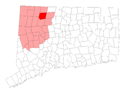 Location in Litchfield County, Connecticut | |
| Coordinates: 41°55′30″N 73°06′11″W | |
| Country | |
| U.S. state | |
| County | Litchfield |
| NECTA | Torrington |
| Region | Northwest Hills |
| Incorporated | 1771 |
| Government | |
| • Type | Board of selectmen-town manager |
| • Town manager | Robert Geiger |
| • Board of selectmen | Althea C. Perez, Mayor Melissa Bird George Closson Todd Arcelaschi Steven Sedlack Jack Bourque Glenn Albanesius |
| Area | |
| • Total | 33.8 sq mi (87.6 km2) |
| • Land | 32.5 sq mi (84.2 km2) |
| • Water | 1.3 sq mi (3.4 km2) |
| Elevation | 1,017 ft (310 m) |
| Population (2010) | |
| • Total | 11,242 |
| • Density | 346/sq mi (133.5/km2) |
| Time zone | UTC-5 (Eastern) |
| • Summer (DST) | UTC-4 (Eastern) |
| ZIP codes | 06094, 06098 |
| Area code(s) | 860 |
| FIPS code | 09-86440 |
| GNIS feature ID | 0213536 |
| Website | www |
History
Winchester was incorporated in 1771, and named after Winchester in England.[2]
Geography
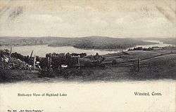
The town is in northeastern Litchfield County and is bordered to the south by the city of Torrington. It is 28 miles (45 km) northwest of Hartford, the state capital, and 27 miles (43 km) north of Waterbury. Winsted, with a population of 7,321 by far the largest community in Winchester, is in the eastern part of the town.
According to the United States Census Bureau, the town has a total area of 33.8 square miles (87.6 km2), of which 32.5 square miles (84.2 km2) are land and 1.3 square miles (3.4 km2), or 3.87%, are water.[1] Highland Lake, Crystal Lake, and Lake Winchester are three of the larger water bodies in the town. The Still River, a tributary of the Farmington River, flows from south to north through the eastern side of the town.
Principal communities
- Winchester Center
- Winsted
Demographics
| Historical population | |||
|---|---|---|---|
| Census | Pop. | %± | |
| 1820 | 1,601 | — | |
| 1850 | 2,179 | — | |
| 1860 | 3,513 | 61.2% | |
| 1870 | 4,096 | 16.6% | |
| 1880 | 5,142 | 25.5% | |
| 1890 | 6,183 | 20.2% | |
| 1900 | 7,763 | 25.6% | |
| 1910 | 8,679 | 11.8% | |
| 1920 | 9,019 | 3.9% | |
| 1930 | 8,674 | −3.8% | |
| 1940 | 8,482 | −2.2% | |
| 1950 | 10,535 | 24.2% | |
| 1960 | 10,496 | −0.4% | |
| 1970 | 11,106 | 5.8% | |
| 1980 | 10,841 | −2.4% | |
| 1990 | 11,524 | 6.3% | |
| 2000 | 10,664 | −7.5% | |
| 2010 | 11,242 | 5.4% | |
| Est. 2014 | 10,929 | [3] | −2.8% |
| U.S. Decennial Census[4] | |||
At the 2000 census there were 10,664 people, 4,371 households, and 2,849 families living in the town. The population density was 330.4 people per square mile (127.6/km²). There were 4,922 housing units at an average density of 152.5 per square mile (58.9/km²). The racial makeup of the town was 94.44% White, 1.24% African American, 0.23% Native American, 0.93% Asian, 0.01% Pacific Islander, 1.69% from other races, and 1.46% from two or more races. Hispanic or Latino people of any race were 3.17%.[5]
Of the 4,371 households 28.3% had children under the age of 18 living with them, 50.3% were married couples living together, 10.2% had a female householder with no husband present, and 34.8% were non-families. 28.0% of households were one person and 11.9% were one person aged 65 or older. The average household size was 2.42 and the average family size was 2.97.
The age distribution was 23.3% under the age of 18, 7.1% from 18 to 24, 29.4% from 25 to 44, 25.0% from 45 to 64, and 15.2% 65 or older. The median age was 40 years. For every 100 females, there were 94.0 males. For every 100 females age 18 and over, there were 90.5 males.
The median household income was $46,671 and the median family income was $57,866. Males had a median income of $41,076 versus $28,058 for females. The per capita income for the town was $22,589. About 4.3% of families and 6.7% of the population were below the poverty line, including 9.9% of those under age 18 and 7.4% of those age 65 or over.
Transportation
The town is served by buses of the Northwestern Connecticut Transit District.
The city of Winsted is located at the junction of Connecticut Route 8 and U.S. Route 44. Route 263 connects Winchester Center and Winsted.
Notable people
- Phineas Miner (1777–1839), congressman from Connecticut; born in Winchester
References
- "Geographic Identifiers: 2010 Census Summary File 1 (G001), Winchester town, Litchfield County, Connecticut". American FactFinder. U.S. Census Bureau. Archived from the original on February 13, 2020. Retrieved October 17, 2019.
- The Connecticut Magazine: An Illustrated Monthly. Connecticut Magazine Company. 1903. p. 335.
- "Annual Estimates of the Resident Population for Incorporated Places: April 1, 2010 to July 1, 2014". Retrieved June 4, 2015.
- "Census of Population and Housing". Census.gov. Retrieved June 4, 2015.
- "U.S. Census website". United States Census Bureau. Retrieved 2008-01-31.
External links
- Town of Winchester official website
- Northwestern Connecticut Community College in Winsted
- Winsted Area Ambulance Association
Municipalities and communities of Litchfield County, Connecticut, United States | ||
|---|---|---|
| Consolidated city | 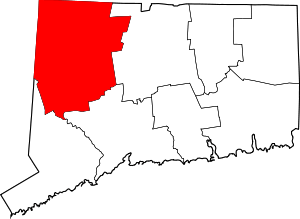 | |
| Towns | ||
| Boroughs | ||
| CDPs | ||
| Other communities | ||
| Indian reservation | ||

| Topics | |||||||
|---|---|---|---|---|---|---|---|
| States | |||||||
| Major cities | |||||||
| State capitals | |||||||
| Transportation |
| ||||||
| |||||||