Cornwall, Connecticut
Cornwall is a town in Litchfield County, Connecticut, United States. The population was 1,420 at the 2010 census.[2]
Cornwall, Connecticut | |
|---|---|
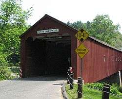
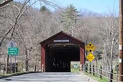 West Cornwall covered bridge | |
 Seal | |
 Location in Litchfield County, Connecticut | |
| Coordinates: 41°50′43″N 73°19′53″W | |
| Country | |
| U.S. state | |
| County | Litchfield |
| Region | Northwest Hills |
| Incorporated (city) | May 1740[1] |
| Government | |
| • Type | Selectman-town meeting |
| • First selectman | Gordon M. Ridgway (D) |
| • Selectman | Richard Bramley (D) |
| • Selectman | Heidi L. Kearns (R) |
| Area | |
| • Total | 46.3 sq mi (120.0 km2) |
| • Land | 46.1 sq mi (119.3 km2) |
| • Water | 0.3 sq mi (0.7 km2) |
| Elevation | 709 ft (216 m) |
| Population (2010) | |
| • Total | 1,420 |
| • Density | 31/sq mi (11.9/km2) |
| Time zone | UTC-5 (EST) |
| • Summer (DST) | UTC-4 (EDT) |
| ZIP code | 06754, 06796 |
| Area code(s) | 860 |
| FIPS code | 09-17240 |
| GNIS feature ID | 0213412 |
| Website | www |
History
Cornwall was incorporated in May 1740[1] and was named after the county of Cornwall in England.[3]
In 1939 poet Mark Van Doren wrote "The Hills of Little Cornwall", in which the seductive beauties of the countryside were portrayed:[4]
- The mind, eager for caresses,
- Lies down at its own risk in Cornwall;
Cornwall also makes a glancing appearance in Wallace Stevens's late poem "Reality is an Activity of the Most August Imagination."
Cornwall played a role in the establishment of Christianity in the Hawaiian islands after a native Hawaiian tragically died here of Typhus in 1818. This tragedy was instrumental in the Congregational church’s 1820 outreach to the ‘Sandwich Islands’ at Kona, Hawaii.[5]
Geography
Cornwall is in northwestern Litchfield County. It is bordered to the north by the town of Canaan, to the east by Goshen, to the south by Warren, to the southwest by Kent, and to the west, across the Housatonic River, by Sharon. According to the United States Census Bureau, the town of Cornwall has a total area of 46.3 square miles (120.0 km2), of which 46.1 square miles (119.3 km2) are land and 0.3 square miles (0.7 km2), or 0.55%, are water.[2] The town contains a major portion of Mohawk State Forest.
Principal communities
- Cornwall Bridge (has its own post office)
- Cornwall Village (has its own post office)
- Cornwall Hollow
- East Cornwall
- West Cornwall (has its own post office)
Demographics
| Historical population | |||
|---|---|---|---|
| Census | Pop. | %± | |
| 1820 | 1,661 | — | |
| 1850 | 2,041 | — | |
| 1860 | 1,953 | −4.3% | |
| 1870 | 1,772 | −9.3% | |
| 1880 | 1,583 | −10.7% | |
| 1890 | 1,283 | −19.0% | |
| 1900 | 1,175 | −8.4% | |
| 1910 | 1,016 | −13.5% | |
| 1920 | 834 | −17.9% | |
| 1930 | 878 | 5.3% | |
| 1940 | 907 | 3.3% | |
| 1950 | 896 | −1.2% | |
| 1960 | 1,051 | 17.3% | |
| 1970 | 1,177 | 12.0% | |
| 1980 | 1,288 | 9.4% | |
| 1990 | 1,414 | 9.8% | |
| 2000 | 1,434 | 1.4% | |
| 2010 | 1,420 | −1.0% | |
| Est. 2014 | 1,398 | [6] | −1.5% |
| U.S. Decennial Census[7] | |||
As of the census[8] of 2000, there were 1,434 people, 615 households, and 389 families residing in the town. The population density was 31.2 people per square mile (12.0/km2). There were 873 housing units at an average density of 19.0 per square mile (7.3/km2). The racial makeup of the town was 97.49% White, 0.21% African American, 0.70% Asian, 0.21% from other races, and 1.39% from two or more races. Hispanic or Latino of any race were 1.46% of the population.

There were 615 households, out of which 29.4% had children under the age of 18 living with them, 52.5% were married couples living together, 8.5% had a female householder with no husband present, and 36.6% were non-families. 30.7% of all households were made up of individuals, and 12.0% had someone living alone who was 65 years of age or older. The average household size was 2.33 and the average family size was 2.93.
In the town, the population was spread out, with 24.4% under the age of 18, 3.3% from 18 to 24, 25.7% from 25 to 44, 28.9% from 45 to 64, and 17.6% who were 65 years of age or older. The median age was 44 years. For every 100 females, there were 94.0 males. For every 100 females age 18 and over, there were 90.5 males.
The median income for a household in the town was $54,886, and the median income for a family was $64,750. Males had a median income of $46,875 versus $30,536 for females. The per capita income for the town was $42,484. About 1.0% of families and 3.0% of the population were below the poverty line, including 3.0% of those under age 18 and 1.6% of those age 65 or over.
Some of the main features of Cornwall include the Cream Hill Lake, the Covered Bridge, Mohawk Ski Mountain and the town which contains a library and tennis courts.
| Voter registration and party enrollment as of October 25, 2005[9] | |||||
|---|---|---|---|---|---|
| Party | Active voters | Inactive voters | Total voters | Percentage | |
| Democratic | 330 | 6 | 336 | 31.97% | |
| Republican | 246 | 4 | 250 | 23.79% | |
| Unaffiliated | 447 | 8 | 455 | 43.29% | |
| Minor Parties | 10 | 0 | 10 | 0.95% | |
| Total | 1,033 | 18 | 1,051 | 100% | |
Education
Cornwall is a member of Regional School District 01, which also includes the towns of Canaan, Kent, North Canaan, Salisbury, and Sharon. Public school students attend the Cornwall Consolidated School for grades K-8 and Housatonic Valley Regional High School for grades 9-12.
Arts and culture
The Cornwall Library, organized in 1869, constructed a new building in 2002 that houses a collection of over 28,000 items. It sponsors a long-running art show, along with many other events.
The Cornwall Chronicle is a non-profit monthly newspaper that publishes news and feature stories about Cornwall, a calendar of events, and drawings by local artists. It was started in 1991 and has not missed an issue since.
Museums and other points of interest
- Cathedral Pines - a 42-acre (17 ha) nature conservatory and old-growth forest
- Cornwall Bridge - concrete arch bridge built in 1930 and listed on the National Register of Historic Places in 2004
- Cornwall Bridge Railroad Station - added to the National Register of Historic Places in 1972
- Cornwall Historical Society - located in a converted carriage barn, features annual exhibits on Cornwall's history
- House VI ("the Frank residence") - an example of Deconstructivist architecture
- Mohawk Mountain Ski Area - a ski resort
- West Cornwall Covered Bridge - listed on the National Register of Historic Places in 1975
The town was home to the Foreign Mission School between 1817 and 1826.
Infrastructure
Transportation
The town is served by Connecticut Route 4, U.S. Route 7, and Connecticut Routes 43, 125 and 128. Route 4 leads east 13 miles (21 km) to Torrington and west 11 miles (18 km) to Sharon, while Route 7 leads north 14 miles (23 km) to North Canaan and south 25 miles (40 km) to New Milford. Routes 43, 125 and 128 are entirely within the town of Cornwall, Route 43 running from North Corners near Cornwall village to Cornwall Hollow, Route 128 running from North Corners to West Cornwall, and Route 125 running from Cornwall Village north to Route 128.
The covered bridge in West Cornwall, crossing the Housatonic River, is one of only three covered bridges in Litchfield County. It has a span of 242 feet (74 m) and has been in continuous service since 1864.
Notable people
https://en.wikipedia.org/wiki/Ralph_C._Harrison
- Ethan Allen (1738–1789), Revolutionary War hero (Green Mountain Boys) and co-founder of the state of Vermont
- Ira Allen (1751–1814), one of the founders of Vermont[10]
- Major Andre Andrews (1792–1834), mayor of Buffalo, New York
- Edward L. Ferman (b. 1937), editor and publisher for Mercury Press magazines and editor of anthologies, most notably of The Magazine of Fantasy and Science Fiction, published in Cornwall for more than a decade
- Tom Jones (b. 1928), composer, The Fantasticks
- Alexandra Paul (b. 1963), actress; raised in Cornwall
- Oliver Platt (b. 1960), actor
- Abraham A. Ribicoff (1910–1998), governor of Connecticut and U.S. senator
- John Sedgwick (1813–1864), Union Army general killed by a sniper at the Battle of Spotsylvania Court House[11]
- Oscar Serlin (1901–1971), Broadway producer, Life with Father
- Marc Simont (1915–2013), artist, political cartoonist and illustrator of children's books
- James Thurber (1894–1961), author (The Secret Life of Walter Mitty), cartoonist and celebrated wit
- Charles Van Doren (1926–2019), historian, notable quiz show contestant, resident
- Mark Van Doren (1894–1972), poet and teacher
- Sam Waterston (b. 1940), actor; lives in West Cornwall
- Josepha Newcomb Whitney (1871–1957), suffragist, pacifist, elected to Connecticut legislature
In popular culture
- The fictional private boarding high school Cornwall Academy from the 1999 film Outside Providence is located in Cornwall, Connecticut.
- In the eleventh episode of the second season of Supernatural, Sam and Dean Winchester explore a haunted bed and breakfast in Cornwall.
- In Season 4, Episode 11 of the television show Gossip Girl, Juliet Sharp returns to her hometown of Cornwall.
- The covered bridge appears in the opening credits of Valley of the Dolls.
References
- "Cornwall, Connecticut". City-Data.com. Retrieved September 22, 2012.
- "Geographic Identifiers: 2010 Census Summary File 1 (G001), Cornwall town, Litchfield County, Connecticut". American FactFinder. U.S. Census Bureau. Archived from the original on February 13, 2020. Retrieved October 7, 2019.
- The Connecticut Magazine: An Illustrated Monthly. Connecticut Magazine Company. 1903. p. 331.
- Academy of American Poets, "The Hills of Little Cornwall", accessed October 7, 2019
- https://mokuaikaua.com/
- "Annual Estimates of the Resident Population for Incorporated Places: April 1, 2010 to July 1, 2014". Archived from the original on May 23, 2015. Retrieved June 4, 2015.
- "Census of Population and Housing". Census.gov. Retrieved June 4, 2015.
- "U.S. Census website". United States Census Bureau. Retrieved 2008-01-31.
- "Registration and Party Enrollment Statistics as of October 25, 2005" (PDF). Connecticut Secretary of State. Archived from the original (PDF) on 2006-09-23. Retrieved 2006-10-02.
- Who Was Who in America, Historical Volume, 1607-1896. Marquis Who's Who. 1967.
- "John Sedgwick". Who’s Who In The Civil war. Retrieved September 19, 2012.
External links
- Official website
- Cornwall Consolidated School
- Cornwall Library
- Cornwall Historical Society
- The Cornwall Chronicle
- The Lakeville Journal
- Housatonic Valley Regional High School in Falls Village
- Cornwall, Connecticut, at City-Data.com
Municipalities and communities of Litchfield County, Connecticut, United States | ||
|---|---|---|
| Consolidated city | 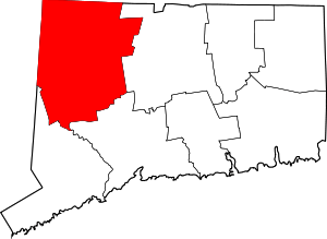 | |
| Towns | ||
| Boroughs | ||
| CDPs | ||
| Other communities | ||
| Indian reservation | ||
| Topics | |||||||
|---|---|---|---|---|---|---|---|
| States | |||||||
| Major cities | |||||||
| State capitals | |||||||
| Transportation |
| ||||||
| |||||||
| Authority control |
|
|---|