Warren, Connecticut
Warren is a town in Litchfield County, Connecticut, United States. The population was 1,461 at the 2010 census,[1] up from 1,254 at the 2000 census. The town was named for Revolutionary War General Joseph Warren.[2]
Warren, Connecticut | |
|---|---|
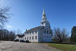 Warren Congregational Church | |
 Seal | |
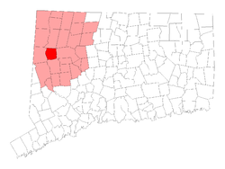 Location in Litchfield County, Connecticut | |
| Coordinates: 41°44′11″N 73°20′32″W | |
| Country | |
| U.S. state | |
| County | Litchfield |
| Region | Northwest Hills |
| Incorporated | 1786 |
| Government | |
| • Type | Selectman-town meeting |
| • First selectman | Craig Nelson |
| Area | |
| • Total | 27.6 sq mi (71.4 km2) |
| • Land | 26.3 sq mi (68.1 km2) |
| • Water | 1.2 sq mi (3.2 km2) |
| Elevation | 1,257 ft (383 m) |
| Population (2010)[1] | |
| • Total | 1,461 |
| • Density | 55/sq mi (21.4/km2) |
| Time zone | UTC-5 (Eastern) |
| • Summer (DST) | UTC-4 (Eastern) |
| ZIP code | 06754 |
| Area code(s) | 860 |
| FIPS code | 09-79510 |
| GNIS feature ID | 0213523 |
| Website | www |
On July 1, 2006, businessman Joseph Cicio placed most of Warren's commercial district on eBay for $5,000,000.[3][4][5][6]
Geography
Warren is in west-central Litchfield County, 28 miles (45 km) north of Danbury, 24 miles (39 km) northwest of Waterbury, and 42 miles (68 km) west of Hartford. According to the United States Census Bureau, the town has a total area of 27.6 square miles (71.4 km2), of which 26.3 square miles (68.1 km2) are land and 1.2 square miles (3.2 km2)|, or 4.50%, are water.[1]
Demographics
| Historical population | |||
|---|---|---|---|
| Census | Pop. | %± | |
| 1820 | 875 | — | |
| 1850 | 830 | — | |
| 1860 | 710 | −14.5% | |
| 1870 | 673 | −5.2% | |
| 1880 | 639 | −5.1% | |
| 1890 | 477 | −25.4% | |
| 1900 | 432 | −9.4% | |
| 1910 | 412 | −4.6% | |
| 1920 | 350 | −15.0% | |
| 1930 | 303 | −13.4% | |
| 1940 | 328 | 8.3% | |
| 1950 | 437 | 33.2% | |
| 1960 | 600 | 37.3% | |
| 1970 | 827 | 37.8% | |
| 1980 | 1,027 | 24.2% | |
| 1990 | 1,226 | 19.4% | |
| 2000 | 1,254 | 2.3% | |
| 2010 | 1,461 | 16.5% | |
| Est. 2014 | 1,427 | [7] | −2.3% |
| U.S. Decennial Census[8] | |||
As of the census[9] of 2000, there were 1,254 people, 497 households, and 353 families living in the town. The population density was 47.7 people per square mile (18.4/km²). There were 650 housing units at an average density of 24.7 per square mile (9.5/km²). The racial makeup of the town was 97.93% White, 0.16% African American, 0.32% Native American, 0.80% Asian, 0.08% from other races, and 0.72% from two or more races. Hispanic or Latino of any race were 0.24% of the population.
There were 497 households out of which 29.8% had children under the age of 18 living with them, 63.6% were married couples living together, 5.0% had a female householder with no husband present, and 28.8% were non-families. 21.9% of all households were made up of individuals and 11.1% had someone living alone who was 65 years of age or older. The average household size was 2.52 and the average family size was 2.97.
In the town, the age distribution of the population shows 22.6% under the age of 18, 5.1% from 18 to 24, 28.3% from 25 to 44, 29.0% from 45 to 64, and 14.9% who were 65 years of age or older. The median age was 42 years. For every 100 females, there were 106.3 males. For every 100 females age 18 and over, there were 105.1 males.
The median income for a household in the town was $62,798, and the median income for a family was $66,563. Males had a median income of $50,469 versus $35,250 for females. The per capita income for the town was $36,801. About 2.8% of families and 3.3% of the population were below the poverty line, including 6.3% of those under age 18 and 2.1% of those age 65 or over.
Transportation
Connecticut Route 45 is the main north-south highway, while Connecticut Route 341 is the main east-west highway in the town. Route 45 leads north 5 miles (8 km) to U.S. Route 7 in Cornwall and south the same distance to New Preston, while Route 341 leads southeast 5 miles to U.S. Route 202 at Woodville and west 8 miles (13 km) to Kent.
Notable locations
- Warren Congregational Church - built in 1818 and added to the National Register of Historic Places in 1991.
Notable people
- Herbert Abrams (1921–2003), portrait artist
- Lorenzo Carter (1767–1814), the first permanent settler of Cleveland, Ohio; born in Warren
- Charles Finney (1792–1875), Presbyterian minister, leader in the Second Great Awakening; born in Warren
- Miloš Forman (1932–2018), film director; lived in Warren with his wife, Martina Forman, an author
- Morton Gottlieb (1921–2009), theatrical and film producer
- Cleve Gray (1918–2004), painter
- Francine du Plessix Gray (1930–2019), writer
- Philip Roth (1933–2018), writer; maintained a house in Warren
References
- "Geographic Identifiers: 2010 Census Summary File 1 (G001), Warren town, Litchfield County, Connecticut". American FactFinder. U.S. Census Bureau. Archived from the original on February 13, 2020. Retrieved October 16, 2019.
- The Connecticut Magazine: An Illustrated Monthly. Connecticut Magazine Company. 1903. p. 335.
- Joe Moore (July 3, 2006). "Warren is on the eBay block: $5 million will buy stores, 14-room colonial, land". Waterbury Republican-American.
- "Parts of downtown Warren for sale on the Internet". WTNH. July 3, 2006.
- "Connecticut Enterprise Digest: Downtown on eBay". Newsday. July 3, 2006.
- eBay: Warren, CT. Town Center. Commercial. Residential. Land. (item 110003719889 end time Jul-30-06 11:21:21 PDT)
- "Annual Estimates of the Resident Population for Incorporated Places: April 1, 2010 to July 1, 2014". Retrieved June 4, 2015.
- "Census of Population and Housing". Census.gov. Retrieved June 4, 2015.
- "U.S. Census website". United States Census Bureau. Retrieved 2008-01-31.
External links
Municipalities and communities of Litchfield County, Connecticut, United States | ||
|---|---|---|
| Consolidated city |  | |
| Towns | ||
| Boroughs | ||
| CDPs | ||
| Other communities | ||
| Indian reservation | ||

| Topics | |||||||
|---|---|---|---|---|---|---|---|
| States | |||||||
| Major cities | |||||||
| State capitals | |||||||
| Transportation |
| ||||||
| |||||||
| Authority control |
|
|---|