Willington, Connecticut
Willington is a town in Tolland County, Connecticut, United States. The population was 6,041 at the 2010 census.
Willington, Connecticut | |
|---|---|
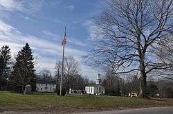 Willington Common | |
 Seal | |
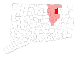 Location within Tolland County, Connecticut | |
| Coordinates: 41°53′07″N 72°15′41″W | |
| Country | |
| U.S. state | |
| County | Tolland |
| Metropolitan area | Hartford |
| Incorporated | May 1727 |
| Government | |
| • Type | Selectman-town meeting |
| • First selectman | Erika Wiecenski |
| • Selectman | Liza Makuch |
| • Selectman | John Blessington (R) |
| Area | |
| • Total | 33.5 sq mi (86.8 km2) |
| • Land | 33.3 sq mi (86.2 km2) |
| • Water | 0.2 sq mi (0.5 km2) |
| Elevation | 761 ft (232 m) |
| Population (2010)[1] | |
| • Total | 6,041 |
| • Density | 187/sq mi (72/km2) |
| Time zone | UTC-5 (Eastern) |
| • Summer (DST) | UTC-4 (Eastern) |
| ZIP code | 06279 |
| Area code(s) | 860 |
| FIPS code | 09-85950 |
| GNIS feature ID | 0213534 |
| Website | www |
The Willimantic River borders the town on the west. Willington is about 25 miles northeast of Hartford on Interstate 84, which also provides a connection to Boston, via the Massachusetts Turnpike. Providence, RI is accessible via U.S. Route 44. Larger communities nearby include Coventry, Stafford, Tolland, and Willimantic. The University of Connecticut is located in adjacent Mansfield. A new public library (formerly located within Hall Memorial School) opened in autumn 2006.
History
In 1720 a party of eight men, originally from England, bought 16,000 acres of the region and called it Wellington.[2] Willington was incorporated in May 1727.[3] Willington became a part of Tolland County when it was formed from portions of eastern Hartford County and western Windham County on 13 October 1785.[4]
The town was well adapted for grazing and lumbering.[5] After a century of farming, the town gradually expanded commercially and industrially. The circa 1815 Daniel Glazier Tavern includes an upstairs ballroom that was used for almost thirty years as a town meetinghouse in cold weather.[6]
By 1845 Willington included a thread mill, a cotton mill, three silk factories, a scythe factory, four comb factories, button mills, a glassworks (1815-1871) producing demijohns and flasks of various designs.[3][5]
Geography
According to the United States Census Bureau, the town has a total area of 33.5 square miles (87 km2), of which 33.3 square miles (86 km2) of it is land and 0.2 square miles (0.52 km2) of it (0.63%) is water.
Notable people
- Roger Wolcott (1679-1767), 28th Governor of the Connecticut Colony (1750-1754), one of the town's founders.
- Orrin Holt (1792–1855), 1st representative of Connecticut's 6th congressional district was born and died in town.
- Jared Sparks (1792–1855), historian, Unitarian minister and President of Harvard University. A street named in his honor extends from the town green to Moose Meadow Road.
- Justus Vinton (1806–1858), a Baptist missionary to Myanmar, was born in town.
- Elias Loomis (1811-1889), a mathematician and astronomer, was born in town.
- Philip Corbin (1824-1910), a businessman and founder of P&F Corbin Company, was born in town.
- Jeremiah Chaplin, (1776-1841), a Reformed Baptist theologian who preached in town.
- William L. Higgins, (1867-1951), a US Congressman and doctor who practiced medicine in town.
- Eleni Benson, (1983-), a soccer player for the Greece women's national football team in the 2004 Summer Olympics.
Demographics
| Historical population | |||
|---|---|---|---|
| Census | Pop. | %± | |
| 1820 | 1,246 | — | |
| 1850 | 1,388 | — | |
| 1860 | 1,166 | −16.0% | |
| 1870 | 942 | −19.2% | |
| 1880 | 1,086 | 15.3% | |
| 1890 | 906 | −16.6% | |
| 1900 | 885 | −2.3% | |
| 1910 | 1,112 | 25.6% | |
| 1920 | 1,200 | 7.9% | |
| 1930 | 1,213 | 1.1% | |
| 1940 | 1,233 | 1.6% | |
| 1950 | 1,462 | 18.6% | |
| 1960 | 2,005 | 37.1% | |
| 1970 | 3,755 | 87.3% | |
| 1980 | 4,694 | 25.0% | |
| 1990 | 5,979 | 27.4% | |
| 2000 | 5,959 | −0.3% | |
| 2010 | 6,041 | 1.4% | |
| Est. 2014 | 5,934 | [7] | −1.8% |
| U.S. Decennial Census[8] | |||
As of the census[9] of 2000 (a 2010 census is available), there were 5,959 people, 2,353 households, and 1,437 families residing in the town. The population density was 179.1 people per square mile (69.2/km²). There were 2,429 housing units at an average density of 73.0 per square mile (28.2/km²). The racial makeup of the town was 94.06% White, 0.97% African American, 0.12% Native American, 3.02% Asian, 0.08% Pacific Islander, 0.62% from other races, and 1.12% from two or more races. Hispanic or Latino of any race were 1.81% of the population.
There were 2,423 households, of which 24.3% had children under the age of 18 living with them, 49.3% were married couples living together, 11.2% were single householders with no spouse present (7.4% female householder, 3.8% male), and 39.5% were non-families. 21.3% of all households were made up of individuals and 5.7% had someone living alone who was 65 years of age or older. The average household size was 2.48 and the average family size was 2.92.
In the town, the population was spread out with 20.4% under the age of 20, 16.9% from 20 to 24, 21.3% from 25 to 44, 30.7% from 45 to 64, and 4.4% who were 65 years of age or older. The median age was 38.3 years.
The median income for a household in the town was $51,690, and the median income for a family was $70,684. Males had a median income of $41,250 versus $36,310 for females. The per capita income for the town was $27,062. About 2.9% of families and 13.3% of the population were below the poverty line, including 4.0% of those under age 18 and 3.1% of those age 65 or over.
Education
Elementary and middle school-aged residents attend schools in the Willington School District.
All residents are zoned to:
- Center Elementary School (Kindergarten through 4)
- Hall Memorial School (Grades 5 through 8)
High school-aged residents attend E. O. Smith High School of the Regional School District 19.
Prior to the community's affiliation with Regional School District 19, Willington offered its high school-aged students a choice attending one of the two institutions. Numbers varied from year to year, having the undesired effect of breaking up classes and bussing them distances of up to 15 miles. The two available choices as of 2018 are:
- E. O. Smith High School in Mansfield, Connecticut
- Windham Technical High School in Windham, Connecticut.
Popular culture
Willington was featured on the Fox science fiction show Fringe in Season 5, Episode 9 (Black Blotter).
Willington was the start of serial killer/kidnapper Peter Manfredonia’s multi-state crime spree where he murdered a resident, injured another and took a third resident hostage in his home.
References
- U.S. Census Bureau Population Estimates
- Chronology of Willington, Connecticut, 1727-1927: The First Two Hundred Years. History Committee. The Willington Historical Society, 1977 - Willington (Conn. : Town) - 120 pages.
- 1976 Historic Marker, erected by the Town of Willington, the Willington Historical Society and the Connecticut Historical Commission.
- History of Tolland County, Connecticut, Including Its Early Years, Volume 1. By J. R. Cole.
- Property and Kinship: Inheritance in Early Connecticut, 1750-1820. By Toby L. Ditz, Princeton University Press, July 14, 2014. Page 21. Accessed 28 April 2019.
- Willington Historical Society Working To Restore Daniel Glazier Tavern. By Michael Walsh, 4 March 2016. Hartford Courant, accessed 28 April 2019.
- "Annual Estimates of the Resident Population for Incorporated Places: April 1, 2010 to July 1, 2014". Retrieved June 4, 2015.
- "Census of Population and Housing". Census.gov. Retrieved June 4, 2015.
- "U.S. Census website". United States Census Bureau. Retrieved 2008-01-31.
External links
Municipalities and communities of Tolland County, Connecticut, United States | ||
|---|---|---|
| Towns |  | |
| CDPs | ||
| Other communities | ||