Colchester, Connecticut
Colchester is a town in New London County, Connecticut, United States. The population was 16,068 at the 2010 census.[1] In 2010 Colchester became the first town in Connecticut, and the 36th in the country, to be certified with the National Wildlife Federation as a Community Wildlife Habitat.
Colchester, Connecticut | |
|---|---|
 Seal | |
 Location in New London County, Connecticut | |
| Coordinates: 41°34′33.4″N 72°19′56.3″W | |
| Country | United States |
| State | Connecticut |
| County | New London |
| Metropolitan area | New London |
| Incorporated | 1698 / 1699 |
| Government | |
| • Type | Selectman–town meeting |
| • First Selectman | Mary Bylone (elected 11/2019) |
| Area | |
| • Total | 49.8 sq mi (129.0 km2) |
| • Land | 49.1 sq mi (127.1 km2) |
| • Water | 0.7 sq mi (1.9 km2) |
| Elevation | 551 ft (168 m) |
| Population (2010) | |
| • Total | 16,068 |
| • Density | 320/sq mi (120/km2) |
| Time zone | UTC-5 (Eastern) |
| • Summer (DST) | UTC-4 (Eastern) |
| ZIP code | 06415, 06420 |
| Area code(s) | 860 Exchange: 537 |
| FIPS code | 09-15910 |
| GNIS feature ID | 0213409 |
| Website | www |
Colchester is one of the fastest growing towns in Connecticut. The villages of Westchester and North Westchester are located within Colchester. The town center village, which was previously incorporated as a borough, is a census-designated place, with a population of 4,781 at the 2010 census.[2]
The Colchester area was part of the Mohegan territory at the time of European settlement. Several members of the Paugussett tribe currently reside in Colchester, Connecticut, where the tribe which has a heritage property in Trumbull has a larger more recently acquired second 106-acre (0.43 km2) reservation.[3]
The Colchester Historical Society operates a local history museum in town.
History
The original settlement of Colchester, was founded by Jeremy Adams upon an area of land known as: "Jerimiah's Farme". The land given to Jeremy, by Uncas, Sachem of the Mohegan tribe.
In 1692, the town of Colchester was confirmed unto Danial Mason, son of Major John Mason.
On October 13, 1698, Michael Taintor, Samuel Northam and Nathaniel Foote III applied to go forth and settle the Town. Jerimiah's Farm was selected as the main point of reference for the town, with its north boundary as the Twenty Mile River. The southern side is bordered by Lyme. The west boundary meets the east bounds of Middletown and Haddam. The east and northeast boundary run to the bounds of Lebanon and Norwich. During the initial settlement, the area was also referred to as the Plantation of the Twenty-mile River.
On May 11, 1699, the town's principal founders, Nathaniel Foote, Samuel Northam and Michael Taintor asked the general court of Hartford for assistance with persons hindering the advancement of the settlement, to be transferred under the jurisdiction of the New London colony, and for the Town to be recognized as Colchester. On May 11, 1699 the town name was so named and incorporated into the colony of New London. The town is said to be named after Colchester,[4] a borough and port in Essex, England, where many colonists had emigrated from, most notably, where Nathaniel's grandfather Nathaniel Foote was born.
Colchester's early history, like that of many towns in New England, centered on the church parish. In 1703, the General Court of the Colony of Connecticut ruled that the settlement could organize a church body here known as Colchester. Within a few years, several grist mills and saw mills were built to provide grain and lumber for the settlement. In 1706, the first street was laid and called Town Street. Nearly 200 feet wide, it is now the southern end of Old Hebron Road. By 1714, there were nearly 50 English colonial families in town.
On 13 Oct 1803 the town of Marlborough, Hartford County was created from parts of the towns of Colchester, Glastonbury, Hartford County, and Hebron, Tolland County.[5][6]
In July 2005, Colchester was named by CNN's Money Magazine, the 57th best place in the U.S. to live in and is celebrated every year with a festival on the last Saturday of September called 57 Fest.
Geography
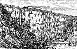
According to the United States Census Bureau, the town has a total area of 49.8 square miles (129 km2), of which 49.1 square miles (127 km2) is land and 0.7 square miles (1.8 km2), or 1.49%, is water. Among the many waterways are the Salmon River, Jeremy River, and Dickinson Creek, which is spanned by the Lyman Viaduct.
Principal communities
- Colchester center
- Golden Hill Paugussett Reservation
- North Westchester
- Westchester
Climate
This climatic region is typified by large seasonal temperature differences, with warm to hot (and often humid) summers and cold (sometimes severely cold) winters. According to the Köppen Climate Classification system, Colchester has a humid continental climate, abbreviated "Dfb" on climate maps.[7]
Activities
Fishing, hiking, and hunting at the Salmon River State Forest.
Landmarks
Formerly an incorporated borough, the town center of Colchester is listed on the National Register of Historic Places as a historic district, known as the Colchester Village Historic District. The walkable center includes a town green with a veterans' memorial. Retail stores and restaurants are located here.
Schools
Colchester has four schools: Colchester Elementary School (Pre K-2), Jack Jackter Intermediate School (Grades 3–5), William J. Johnston Middle School (Grades 6–8), and Bacon Academy (Grades 9–12).
Demographics
| Historical population | |||
|---|---|---|---|
| Census | Pop. | %± | |
| 1820 | 2,152 | — | |
| 1850 | 2,468 | — | |
| 1860 | 2,862 | 16.0% | |
| 1870 | 3,383 | 18.2% | |
| 1880 | 2,974 | −12.1% | |
| 1890 | 2,988 | 0.5% | |
| 1900 | 1,991 | −33.4% | |
| 1910 | 2,140 | 7.5% | |
| 1920 | 2,050 | −4.2% | |
| 1930 | 2,134 | 4.1% | |
| 1940 | 2,338 | 9.6% | |
| 1950 | 3,007 | 28.6% | |
| 1960 | 4,648 | 54.6% | |
| 1970 | 6,603 | 42.1% | |
| 1980 | 7,761 | 17.5% | |
| 1990 | 10,980 | 41.5% | |
| 2000 | 14,551 | 32.5% | |
| 2010 | 16,068 | 10.4% | |
| Est. 2014 | 16,192 | [8] | 0.8% |
| U.S. Decennial Census[9] | |||
As of the census[10] of 2000, there were 14,551 people, 5,225 households, and 3,997 families residing in the town. The population density was 296.6 people per square mile (114.5/km2). There were 5,407 housing units at an average density of 110.2 per square mile (42.6/km2). The racial makeup of the town was 94.53% White, 2.37% African American, 0.42% Native American, 0.60% Asian, 0.01% Pacific Islander, 0.75% from other races, and 1.32% from two or more races. Hispanic or Latino of any race were 1.92% of the population.
There were 5,225 households, out of which 43.0% had children under the age of 18 living with them, 63.9% were married couples living together, 9.2% had a female householder with no husband present, and 23.5% were non-families. 18.2% of all households were made up of individuals, and 5.9% had someone living alone who was 65 years of age or older. The average household size was 2.75 and the average family size was 3.14.
In the town, the population was spread out, with 29.8% under the age of 18, 4.8% from 18 to 24, 36.5% from 25 to 44, 19.7% from 45 to 64, and 9.2% who were 65 years of age or older. The median age was 35 years. For every 100 females, there were 94.4 males. For every 100 females age 18 and over, there were 92.3 males.
The median income for a household in the town was $64,807, and the median income for a family was $62,346. Males had a median income of $47,123 versus $29,250 for females. The per capita income for the town was $24,038. About 6.1% of families and 2.7% of the population were below the poverty line, including 1.6% of those under age 18 and 4.5% of those age 65 or over.
| Voter Registration and Party Enrollment as of October 29, 2019[11] | |||||
|---|---|---|---|---|---|
| Party | Active Voters | Inactive Voters | Total Voters | Percentage | |
| Democratic | 3,180 | 411 | 3,591 | 29.90% | |
| Republican | 2,529 | 293 | 2,822 | 23.50% | |
| Unaffiliated | 4,454 | 933 | 5,387 | 44.85% | |
| Minor Parties | 194 | 16 | 210 | 1.75% | |
| Total | 10,357 | 1,653 | 12,010 | 100% | |
Notable people
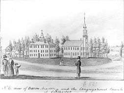
- John Adams (1772–1863), founder of Phillips Exeter Academy, was the principal of the Bacon Academy here from 1803–1810.[12]
- Prince Saunders (1775–1839), attorney general of the Republic of Haiti
- Abigail Goodrich Whittelsey (1788–1858), editor
- Stephen F. Austin (1793–1836), "Father of Texas", attended Bacon Academy in 1803
- Eliphalet Adams Bulkeley (1803–1872), Bacon Academy graduate (1819), state senator, state's attorney and founder of Aetna Insurance Company (1846)
- Denison Worthington (1806–1880), Wisconsin state senator
- William Adams (1807–1880), born in Colchester, noted clergyman and president of Union Theological Seminary (New York)[12]
- Lyman Trumbull (1813–1896), born in Colchester, Bacon Academy graduate (1829), became influential as a U.S. senator representing the state of Illinois during the Civil War and Reconstruction
- Henry C. Deming (1815–1872), mayor of Hartford, mayor of New Orleans, colonel in the Union Army and U.S. congressman
- Alfred Ely (1815–1892), US congressman of New York and taken prisoner after the First Battle of Bull Run
- Edward Sheffield Bartholomew (1822–1858), sculptor
- Ezra Hall Gillett (1823–1875), author, clergyman, and professor
- Rick Derringer (1947–), rock artist and producer
- Ron Wotus (1961–), Bacon Academy graduate (1979), San Francisco Giants bench coach
- Jonathan Coulton (1970–), singer-songwriter
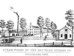
- Nathaniel Hayward (1808–1865), Inventor, Business Owner
References
- "Profile of General Population and Housing Characteristics: 2010 Demographic Profile Data (DP-1): Colchester town, New London County, Connecticut". United States Census Bureau. Retrieved October 24, 2012.
- "Profile of General Population and Housing Characteristics: 2010 Demographic Profile Data (DP-1): Colchester CDP, Connecticut". United States Census Bureau. Retrieved October 24, 2012.
- "Aurelius Piper, chief of Connecticut tribe". Associated Press. Boston Globe. 2008-08-06. Retrieved 2010-08-07.
- Gannett, Henry (1905). The Origin of Certain Place Names in the United States. Govt. Print. Off. pp. 87.
- Conn. Spec. Acts 1803, 2:1157–1158.
- "New London County". Archived from the original on November 10, 2013. Retrieved January 7, 2013.
- Climate Summary for Colchester, Connecticut
- "Annual Estimates of the Resident Population for Incorporated Places: April 1, 2010 to July 1, 2014". Archived from the original on May 23, 2015. Retrieved June 4, 2015.
- "Census of Population and Housing". Census.gov. Retrieved June 4, 2015.
- "U.S. Census website". United States Census Bureau. Retrieved 2008-01-31.
- "Registration and Party Enrollment Statistics as of October 29, 2019" (PDF). Connecticut Secretary of State. Retrieved 2020-03-22.
- Who Was Who in America, Historical Volume, 1607–1896. Chicago: Marquis Who's Who. 1963.
External links
Municipalities and communities of New London County, Connecticut, United States | ||
|---|---|---|
| Cities | 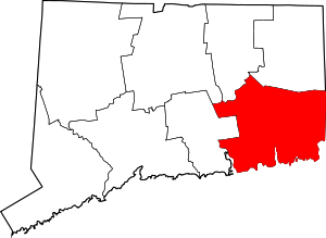 | |
| Towns | ||
| Boroughs | ||
| CDPs | ||
| Other communities | ||
| Indian reservations | ||
| Footnotes | ‡This populated place also has portions in an adjacent county or counties | |
| Authority control |
|
|---|