Bloomfield, Connecticut
Bloomfield is a town in Hartford County, Connecticut, United States. The population was 20,486 at the 2010 census.[1]
Bloomfield, Connecticut | |
|---|---|
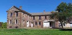 Capt. Oliver Filley House | |
 Seal | |
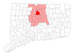 Location within Hartford County, Connecticut | |
| Coordinates: 41°51′N 72°44′W | |
| Country | |
| U.S. state | |
| County | Hartford |
| Metropolitan area | Hartford |
| Settled | 1660 |
| Incorporated | May 28, 1835 |
| Communities | Bloomfield Blue Hills Cottage Grove North Bloomfield |
| Government | |
| • Type | Council-manager |
| • Town manager | Robert E. Smith |
| • Town council | Suzette DeBeatham-Brown, Mayor Rickford R. Kirton, Deputy Mayor Patrick DeLorenzo Kevin Gough David M. Mann Danielle C. Wong Stephanie Calhoun Joseph Merritt Francis Politis |
| Area | |
| • Total | 26.3 sq mi (68.0 km2) |
| • Land | 26.1 sq mi (67.6 km2) |
| • Water | 0.2 sq mi (0.4 km2) |
| Elevation | 138 ft (42 m) |
| Population (2010) | |
| • Total | 20,486 |
| • Density | 778.9/sq mi (300.7/km2) |
| Time zone | UTC-5 (EST) |
| • Summer (DST) | UTC-4 (EDT) |
| ZIP code | 06002 |
| Area code(s) | 860 |
| FIPS code | 09-05910 |
| GNIS feature ID | 0213392 |
| Highways | |
| Website | www |
History
Originally land of the Poquonocks, the area was first settled in 1660 as part of Windsor, organized as the Parish of Wintonbury in 1736. Wintonbury comes from three names from neighboring towns Windsor, Farmington, and Simsbury. It was finally incorporated as the town of Bloomfield by the Connecticut General Assembly on May 28, 1835.[2] Initially, the town's local economy was agriculturally based, mostly in shade tobacco, remaining as such until it developed as a postwar suburb of Hartford starting in the 1950s. Today, Bloomfield's local character varies. While the town's southern and eastern fringes are more densely populated and developed, the northern and western sections maintain a more rural feel with meadows, woods, and some remaining farmland.
Geography
According to the United States Census Bureau, the town has a total area of 26.3 square miles (68.0 km2), of which 26.1 square miles (67.6 km2) is land and 0.15 square miles (0.4 km2), or 0.63%, is water.[1]
Bloomfield is bordered by Windsor to the northeast, East Granby to the north, Simsbury and Avon to the west, and West Hartford and Hartford to the south.
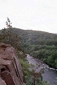
The northern border of Bloomfield is formed by the Farmington River. The west side of the town is flanked by Talcott Mountain, part of the Metacomet Ridge, a mountainous trap rock ridgeline that stretches from Long Island Sound to nearly the Vermont border. Notable features of the Metacomet Ridge in Bloomfield include Penwood State Park and the Tariffville Gorge of the Farmington River, on the borders of East Granby, Simsbury, and Bloomfield. The 51-mile (82 km) Metacomet Trail traverses the ridge.
Transportation
The major east-west throughway in Bloomfield is Route 218, which starts at the Simsbury Road/Hall Boulevard split at the West Hartford line and inches north toward Cottage Grove Road before heading eastbound. Bloomfield also has two major north-south highways: Blue Hills Avenue (Route 187) and Bloomfield/Tunxis Avenues (Route 189). These highways merge when approaching the Windsor line but before returning to Bloomfield.
Eleven bus routes in Connecticut Transit's Hartford Division serve Bloomfield: 36, 46, 50, 52, 54, 56, 72, 74, 76, 92, and 153.
Demographics
| Historical population | |||
|---|---|---|---|
| Census | Pop. | %± | |
| 1850 | 1,412 | — | |
| 1860 | 1,401 | −0.8% | |
| 1870 | 1,473 | 5.1% | |
| 1880 | 1,346 | −8.6% | |
| 1890 | 1,308 | −2.8% | |
| 1900 | 1,513 | 15.7% | |
| 1910 | 1,821 | 20.4% | |
| 1920 | 2,394 | 31.5% | |
| 1930 | 3,247 | 35.6% | |
| 1940 | 4,309 | 32.7% | |
| 1950 | 5,746 | 33.3% | |
| 1960 | 13,613 | 136.9% | |
| 1970 | 18,301 | 34.4% | |
| 1980 | 18,608 | 1.7% | |
| 1990 | 19,483 | 4.7% | |
| 2000 | 19,587 | 0.5% | |
| 2010 | 20,486 | 4.6% | |
| Est. 2014 | 20,819 | [3] | 1.6% |
| U.S. Decennial Census[4] | |||
As of the census[5] of 2010, there were 20,486 people, 8,554 households, and 5,343 families residing in the town. The population density was 753.0 people per square mile (290.8/km2). There were 8,195 housing units at an average density of 315.0 per square mile (121.6/km2). The racial makeup of the town was 35.7% White, 57.5% African American, 0.03% Native American, 1.9% Asian, 0.01% Pacific Islander, 1.70% from other races, and 3% from two or more races. Hispanic or Latino of any race were 5.6% of the population.
There were 8,554 households, out of which 19.3% had children under the age of 18 living with them, 41.8% were married couples living together, 16.9% had a female householder with no husband present, and 37.5% were non-families. 31.9% of all households were made up of individuals, and 17.0% had someone living alone who was 65 years of age or older. The average household size was 2.32 and the average family size was 2.94.
In the town, the population was spread out, with 21.4% under the age of 18, 5.8% from 18 to 24, 24.5% from 25 to 44, 26.6% from 45 to 64, and 21.7% who were 65 years of age or older. The median age was 47.9 years. For every 122 females there were 100 males. For every 130 females age 18 and over, there were 100 males.
The median income for a household in the town was $73,519, and the median income for a family was $84,735.
As of the census[5] of 2000. Males had a median income of $42,860 versus $36,778 for females. The per capita income for the town was $28,843.
U.S. Census Bureau, 2010-2014 American Community Survey 5-Year Estimates, About 5.8% of families and 7.9% of the population were below the poverty line, including 7.2% of those under age 18 and 6.7% of those age 65 or over.
Government & Politics
| Year | Democratic | Republican | Third Parties |
|---|---|---|---|
| 2016 | 82.80% 9,637 | 14.46% 1,683 | 2.74% 319 |
| 2012 | 83.41% 9,921 | 16.18% 1,925 | 0.41% 49 |
| 2008 | 84.96% 10,384 | 14.55% 1,778 | 0.49% 60 |
| 2004 | 76.58% 8,156 | 21.94% 2,337 | 1.47% 157 |
| 2000 | 78.20% 7,907 | 18.29% 1,849 | 3.51% 355 |
| 1996 | 74.15% 6,930 | 19.26% 1,800 | 6.59% 616 |
| 1992 | 65.40% 6,914 | 22.14% 2,341 | 12.46% 1,317 |
| 1988 | 65.36% 6,648 | 33.53% 3,410 | 1.11% 113 |
| 1984 | 57.56% 5,803 | 42.07% 4,241 | 0.37% 37 |
| 1980 | 51.99% 5,119 | 32.59% 3,209 | 15.42% 1,518 |
| 1976 | 55.73% 5,511 | 43.95% 4,346 | 0.32% 32 |
| 1972 | 52.83% 5,212 | 46.48% 4,585 | 0.69% 68 |
| 1968 | 60.17% 5,246 | 36.56% 3,187 | 3.27% 285 |
| 1964 | 70.59% 5,318 | 29.41% 2,216 | 0.00% 0 |
| 1960 | 54.64% 3,777 | 45.36% 3,136 | 0.00% 0 |
| 1956 | 37.45% 1,851 | 62.55% 3,091 | 0.00% 0 |
| Voter registration and party enrollment as of October 29, 2019[7] | |||||
|---|---|---|---|---|---|
| Party | Active voters | Inactive voters | Total voters | Percentage | |
| Democratic | 9,151 | 354 | 9,505 | 60.11% | |
| Republican | 1,381 | 68 | 1,449 | 9.16% | |
| Unaffiliated | 4,390 | 281 | 4,671 | 29.54% | |
| Minor parties | 175 | 13 | 188 | 1.19% | |
| Total | 15,097 | 716 | 15,813 | 100% | |
Economy
Top employers
According to Bloomfield's 2011 Comprehensive Annual Financial Report,[8] the top employers in the city are:
| # | Employer | # of Employees |
|---|---|---|
| 1 | Cigna | 3,463 |
| 2 | MetLife | 2,000 |
| 3 | Kaman | 924 |
| 4 | Town of Bloomfield | 643 |
| 5 | HomeGoods | 572 |
| 6 | Jacobs Vehicle Systems | 475 |
| 7 | Seabury | 400 |
| 8 | Duncaster | 276 |
| 9 | Pepperidge Farm | 260 |
| 10 | Coherent | 220 |
| 11 | SS&C Technologies | 350 |
| 12 | Sun Life Financial | 350 |
| 13 | Beacon Industries | 150 |
| 14 | The Home Depot | 130 |
| 15 | Otis Elevator Company | 110 |
Schools
Bloomfield is home to three secondary schools: the public Bloomfield High School, the inter-district Global Experience Magnet School (serving grades 6-12), and the Metropolitan Learning Center, a CREC school serving grades 6-12.
Bloomfield also has:
PK3 - K The Wintonbury Early Childhood Magnet School
K-2 Laurel Elementary
3-4 Metacomet Elementary
5-6 Carmen Arace Intermediate
7-8 Carmen Arace Middle School
Notable people
- Clarence H. Adams (1905-1987), Commissioner of U.S. Securities and Exchange Commission and President of NBA's Boston Celtics
- George Ansbro (1915-2011), radio announcer
- LeRoy Bailey Jr. (1946-), pastor and author
- Edward C. Banfield, political scientist
- James G. Batterson (1823-1901), founder of Travelers Insurance Company
- Julia Brace (1807-1884), deaf/blind woman of 19th Century
- Lawrence Clay-Bey (1965-), professional heavyweight boxer, born in town
- Marcus Cooper (1990-), cornerback for Chicago Bears
- Joe D'Ambrosio (1953-), sports broadcaster and play-by-play announcer
- Edgar Eno, state assemblyman for Wisconsin
- Oliver Filley (1806-1881), mayor of St. Louis from 1858 to 1861
- Dwight Freeney, NFL All-Pro defensive end for Indianapolis Colts, attended Bloomfield High School
- Edward H. Gillette (1840–1918), congressman for Iowa, born in town
- Jessica Hecht (1965-), actress, born in town
- Jai Johanny Johanson, drummer for Allman Brothers Band
- K.C. Jones (1932-), NBA Hall of Fame basketball player
- Charles Kaman (1919-2011), aeronautical engineer, businessman, inventor and philanthropist
- Ellie Kanner, film and television director and former casting director
- Joža Karas (1926-2008), musician and teacher who made public music composed by inmates of Theresienstadt concentration camp during World War II
- Noella Marcellino (1951-), Benedictine nun who earned doctorate in microbiology from University of Connecticut, became Roman Catholic nun at Benedictine Abbey of Regina Laudis in town; she won Fulbright scholarship to France to collect and examine native strains of fungi, with an emphasis on Geotrichum candidum, from traditional cheese caves and stayed an additional three years, analyzing samples on grant from French government
- Anika Noni Rose (1972-), singer and actress, born in town
- Nykesha Sales (1976-), WNBA basketball player, born in town
- Franz Schurmann (1926–2010), sociologist and historian
- Johann Smith (1987–), soccer player
- James Thorpe (1915–2009), Princeton University professor and academic; lived his later years and died in town
- David Ushery (1967–), television news anchor
- Douglas Wimbish (1956-), bass player
On the National Register of Historic Places
- Connecticut General Life Insurance Company (Cigna) Headquarters[9]
- Capt. Oliver Filley House[10][11]
- Francis Gillette House[12]
- Old Farm Schoolhouse[13]
- Southwest District School[14]
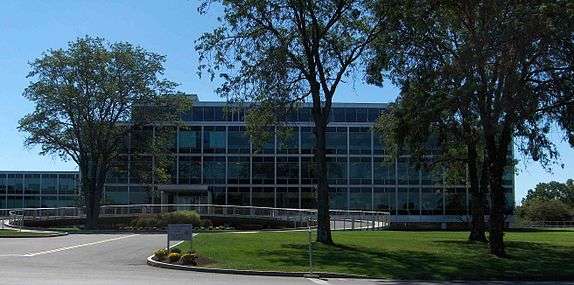 Cigna Headquarters
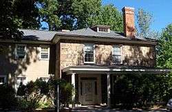 Francis Gillette House
 Old Farm Schoolhouse
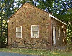 Southwest School District
Places of interest
- The New England Muscle Bicycle Museum, with 120 bicycles from the 1960s and 1970s, is open by appointment
- The First Cathedral, the largest non-denominational church in New England
References
- "Geographic Identifiers: 2010 Demographic Profile Data (G001): Bloomfield town, Hartford County, Connecticut". U.S. Census Bureau, American Factfinder. Archived from the original on February 12, 2020. Retrieved November 26, 2012.
- The Connecticut Magazine: An Illustrated Monthly. Connecticut Magazine Company. 1903. p. 331.
- "Annual Estimates of the Resident Population for Incorporated Places: April 1, 2010 to July 1, 2014". Archived from the original on 2015-05-23. Retrieved June 4, 2015.
- "Census of Population and Housing". Census.gov. Retrieved June 4, 2015.
- "U.S. Census website". United States Census Bureau. Retrieved 2008-01-31.
- https://authoring.ct.gov//SOTS/Election-Services/Statement-Of-Vote-PDFs/General-Elections-Statement-of-Vote-1922
- "Registration and Party Enrollment Statistics as of October 29, 2019" (PDF). Connecticut Secretary of State. Retrieved 2020-02-17.
- "Town of Bloomfield CAFR". Archived from the original on 2014-08-10. Retrieved 2012-07-05.
- "WEEKLY LIST OF ACTIONS TAKEN ON PROPERTIES". National Park Service. Retrieved 20 September 2010.
- "Filley House". Wintonbury Historical Society, Inc. Retrieved 19 September 2010.
- National Register of Historic Places listings in Hartford County, Connecticut
- "Francis Gillette House". bloomfieldct.org. Archived from the original on 27 January 2009. Retrieved 19 September 2010.
- "Old Farm Schoolhouse". bloomfieldct.org. Archived from the original on 18 September 2010. Retrieved 19 September 2010.
- "SW District School". Wintonbury Historical Society, Inc. Retrieved 19 September 2010.
External links

Municipalities and communities of Hartford County, Connecticut, United States | ||
|---|---|---|
| Cities | 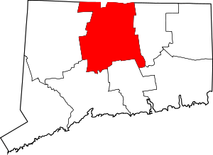 | |
| Towns | ||
| CDPs | ||
| Other communities | ||
| Authority control |
|
|---|