New Milford, Connecticut
New Milford is a town in Litchfield County, Connecticut, United States. The town is in western Connecticut, 14 miles (23 km) north of Danbury, on the banks of the Housatonic River. It is the largest town in the state in terms of land area at nearly 62 square miles (161 km2). The population was 28,142 according to the 2010 census,[6] up from 27,121 at the 2000 census. The town center is listed as a census-designated place (CDP). The northern portion of the town is part of the region of northwestern Connecticut, and the far eastern portions are part of the Litchfield Hills region.
New Milford, Connecticut Town of New Milford | |
|---|---|
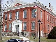
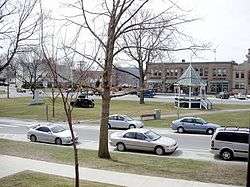 The town green | |
 Flag  Seal | |
| Motto(s): "Gateway to Litchfield County"[1] | |
 Location in Litchfield County, Connecticut | |
 New Milford Location in the contiguous United States 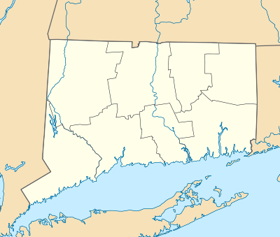 New Milford Location in Connecticut | |
| Coordinates: 41°34′37″N 73°24′30″W | |
| Country | |
| U.S. state | |
| County | Litchfield |
| NECTA | Danbury |
| Region | Western CT |
| Settled | 1707 |
| Incorporated | 1712[2] |
| Government | |
| • Type | Mayor-council |
| • Mayor | Pete Bass[3] |
| • Town Council | Town Council[4]
|
| Area | |
| • Total | 63.7 sq mi (165.0 km2) |
| • Land | 61.6 sq mi (159.5 km2) |
| • Water | 2.1 sq mi (5.5 km2) |
| Elevation | 236 ft (72 m) |
| Population (2010) | |
| • Total | 28,142 |
| • Density | 457/sq mi (176.5/km2) |
| Time zone | UTC-5 (Eastern) |
| • Summer (DST) | UTC-4 (Eastern) |
| ZIP codes | 06755, 06776 |
| Area code(s) | 860 |
| FIPS code | 09-52630 |
| GNIS feature ID | 209242[5] |
| Website | www |
It is located roughly 50 miles (80 km) west of Hartford, 65 miles (105 km) southwest of Springfield, Massachusetts, 85 miles (137 km) southeast of Albany, New York, and 77 miles (124 km) northeast of New York City.
History
Native Americans
The indigenous Wawyachtonoc, lived in the area of modern New Milford both before and during the colonial era. They had a farming and fishing culture, cultivating corn, squash, beans and tobacco, and fishing in freshwater areas. They may have also travelled to the coast to fish during the summer months.[7] They spoke an Algonquian language.
Colonial times
In 1707, John Noble Sr., previously of Westfield, Massachusetts, and his eight-year-old daughter Sarah Noble were the first Anglo-American settlers. (A public school was later named after Sarah Noble.) They were soon joined by others who had bought land there.[8]
On October 17, 1711, twelve families (including a total about 70 people) petitioned the Connecticut General Assembly to create the town, together with the associated privilege of levying a tax to support a minister. With the legislature's approval, the town was organized the next year. The residents soon secured Daniel Boardman to preach, and he was ordained as the minister of the Congregational Church on November 21, 1716.[8][9]
American Revolution
Roger Sherman lived in New Milford before moving to New Haven in 1761.[8] He later became a member of the Continental Congress and signed both the Declaration of Independence and U.S. Constitution. The lot of his former house is the site of the present Town Hall.
During the American Revolution, the 7th Connecticut Regiment (also known as the 19th Continental Regiment) was raised in town on September 16, 1776. The regiment, and the New Milford men in it, would see action in the Battle of Brandywine, Battle of Germantown and the Battle of Monmouth. In total, the town "sent 285 men to fight in the War out of a total population of 2,776."[8]
The Boardman family
- David Sherman Boardman (1768–1864) was the youngest child of Deacon Sherman and Sarah (Bostwick) Boardman. He became a lawyer in town and later chief judge in Litchfield County Court. He served as judge of probate for the district of New Milford in 1805, and held the place by successive annual appointments for sixteen years. He was elected Representative to the General Assembly eight times.
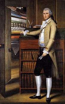
- Elijah Boardman (1760–1823) was a U.S. senator representing Connecticut. Born in New Milford, he was educated by private tutors, and served in the Revolutionary War.
- William Whiting Boardman (1794–1871), a U.S. Representative born in town, was the son of Elijah Boardman. He was a Connecticut state senator in the fourth district, 1830–32, a member of the Connecticut State House of Representatives, 1836–39, 1845, and 1849–51; Speaker of the Connecticut State House of Representatives, 1836, 1839, and 1845; US Representative from Connecticut's second district, 1840–43. He died in New Haven, and is interred at Grove Street Cemetery in New Milford.


19th and 20th centuries
In the second half of the 19th century, many new industries came to town. The Water Witch Hose Company No. 2, local telephone and electricity companies, and newspapers were all founded. Factories in town made buttons, paint and varnish, hats, furniture, pottery, lime, dairy products and pasteboard, among other goods. Tobacco became the major crop in the area, and tobacco warehouses sprang up to handle its storage and processing before sales.[8]
In 1942 Buck's Rock Camp was founded off Bucks Rock Road, and has remained in operation ever since.
21st century
The town has constructed a 1,000,000-gallon sewer plant expansion on West Street, a sewer pump station on Boardman Road, reconstruction of the Rte. 67/ Grove Street Intersection, and ambulance facility on Scovill Street.
The town has added a skate park at Young's Field (2006), reconstructed the tennis and basketball courts at Young's Field (2010), reconstructed the basketball court at Williamson Park in Gaylordsville (2010), and improved Lynn Deming Park (2017), and is working on the New Milford River Trail,[10] which will eventually join the existing 1.5-mile Sega Meadows Park trail (2012), 3.5 miles of River Road, and the 0.25-mile Young's Field River Trail (2017) and link them to the greenways in the neighboring towns of Brookfield and Kent.[11] Several streetscape projects were completed by the Department of Public Works (DPW) with grant money on Church Street, Whittlesey Avenue, and the west side of East Street (2009/2010). Candlewoof Dog Park is completed on Pickett District Road. A bocce ball court was constructed at the Senior Center by Boy Scout Troop 66 (2012).
National Register of Historic Places sites
- Boardman's Bridge — Boardman Road at Housatonic River, northwest of New Milford (added June 13, 1976)
- Carl F. Schoverling Tobacco Warehouse — 1 Wellsville Avenue (added May 12, 1982)
- E. A. Wildman & Co. Tobacco Warehouse — 34 Bridge Street (added November 20, 1988)
- Hine-Buckingham Farms — 44, 46, and 48 Upland Road, 78, 81 Crossman Road (added June 7, 2004)
- Housatonic Railroad Station — Railroad Street (added April 1, 1984)
- J. S. Halpine Tobacco Warehouse — West and Mill Streets (added 1982)
- John Glover Noble House (added September 29, 1977)
- Lover's Leap Bridge — south of New Milford on Pumpkin Hill Road (added June 13, 1976)
- Merritt Beach & Son Building — 30 Bridge Street (added May 28, 1992)
- Merryall Union Evangelical Society Chapel — Chapel Hill Road (added July 5, 1986)
- New Milford Center Historic District — Bennitt and Elm Streets, Center Cemetery, East, South Main, Mill, and Railroad Streets (added July 13, 1986)
- United Bank Building — 19-21 Main Street (added May 12, 1982)
Geography
New Milford is located on the northeastern shore of Candlewood Lake. The Aspetuck River, Still River and Housatonic River flow through the town.
According to the United States Census Bureau, the town has a total area of 63.7 square miles (165.1 km2), making it the largest town in Connecticut. 61.6 square miles (159.5 km2) of it are land, and 2.2 square miles (5.6 km2) of it (3.40%) are water.[6] The CDP corresponding to the town center has a total area of 3.4 square miles (8.8 km2). 3.4 square miles (8.8 km2) of it is land and 0.04 square miles (0.10 km2) of it (0.88%) is water.
Principal communities
- Gaylordsville (06755)
- Boardman Bridge
- Lower Merryall
- Merwinsville
- New Milford Center
- Northville
- Park Lane
- Still River
- Upper Merryall
- Lanesville
- Downtown
- Candlewood Hills
- Sunny Valley
- SouthSide
Climate
New Milford has a humid continental climate, with mild to warm humid summers and cold to very cold winters. The highest recorded temperature was 103 °F (39 °C) in July 1966, while the lowest recorded temperature was -15 °F (-26 °C) in 1968.[12] Snowfall is generally frequent in winter while average precipitation is most common in September.
| Climate data for New Milford, Connecticut | |||||||||||||
|---|---|---|---|---|---|---|---|---|---|---|---|---|---|
| Month | Jan | Feb | Mar | Apr | May | Jun | Jul | Aug | Sep | Oct | Nov | Dec | Year |
| Record high °F (°C) | 71 (22) |
77 (25) |
92 (33) |
95 (35) |
97 (36) |
98 (37) |
106 (41) |
103 (39) |
100 (38) |
89 (32) |
82 (28) |
76 (24) |
106 (41) |
| Average high °F (°C) | 36 (2) |
40 (4) |
49 (9) |
61 (16) |
72 (22) |
81 (27) |
85 (29) |
83 (28) |
75 (24) |
63 (17) |
51 (11) |
40 (4) |
61 (16) |
| Average low °F (°C) | 19 (−7) |
22 (−6) |
29 (−2) |
39 (4) |
48 (9) |
59 (15) |
64 (18) |
62 (17) |
53 (12) |
42 (6) |
34 (1) |
25 (−4) |
41 (5) |
| Record low °F (°C) | −18 (−28) |
−10 (−23) |
−9 (−23) |
14 (−10) |
26 (−3) |
36 (2) |
40 (4) |
38 (3) |
28 (−2) |
19 (−7) |
10 (−12) |
−11 (−24) |
−18 (−28) |
| Average precipitation inches (mm) | 3.76 (96) |
3.30 (84) |
4.43 (113) |
4.36 (111) |
4.57 (116) |
4.74 (120) |
4.99 (127) |
4.55 (116) |
4.66 (118) |
4.89 (124) |
4.54 (115) |
4.16 (106) |
52.95 (1,345) |
| Source: [13] | |||||||||||||
Demographics
| Historical population[14] | |
| 1756 | 1,137 |
| 1774 | 2,776 |
| 1782 | 3,015 |
| 1790 | 3,167 |
| 1800 | 3,221 |
| 1810 | 3,537 |
| Historical population | |||
|---|---|---|---|
| Census | Pop. | %± | |
| 1820 | 3,830 | — | |
| 1850 | 4,508 | — | |
| 1860 | 3,535 | −21.6% | |
| 1870 | 3,586 | 1.4% | |
| 1880 | 3,907 | 9.0% | |
| 1890 | 3,917 | 0.3% | |
| 1900 | 4,804 | 22.6% | |
| 1910 | 5,010 | 4.3% | |
| 1920 | 4,781 | −4.6% | |
| 1930 | 4,700 | −1.7% | |
| 1940 | 5,559 | 18.3% | |
| 1950 | 5,799 | 4.3% | |
| 1960 | 8,318 | 43.4% | |
| 1970 | 14,601 | 75.5% | |
| 1980 | 19,420 | 33.0% | |
| 1990 | 23,629 | 21.7% | |
| 2000 | 27,121 | 14.8% | |
| 2010 | 28,142 | 3.8% | |
| Est. 2017 | 27,380 | [15] | −2.7% |
| U.S. Decennial Census[16] | |||
As of the census[17] of 2010, there were 28,142 people, 10,618 households, and 7,503 families residing in the town. The population density was 456.9 people per square mile (176.4/km²). There were 11,731 housing units at an average density of 190.4 per square mile (73.5/km²). The racial makeup of the town was 91.71% White, 1.72% Black or African American, 0.24% Native American, 2.77% Asian, 0.04% Pacific Islander, 1.65% from other races, and 1.87% from two or more races. Hispanic or Latino of any race was 6.02% of the population.
Of the 10,618 households 33.4% had children under the age of 18 living with them, 58.0% were married couples living together, 8.8% had a female householder with no husband present, and 29.3% were non-families. 23.0% of all households were made up of individuals and 7.9% had someone living alone who was 65 years of age or older. The average household size was 2.62 and the average family size was 3.13.
In the town, the population had 24.30% under the age of 18, 6.87% from 18 to 24, 24.90% from 25 to 44, 31.75% from 45 to 64, and 12.18% who were 65 years of age or older. The median age was 41.4 years. For every 100 females, there were 97.4 males. For every 100 females age 18 and over, there were 93.6 males.
As of the 2000 Census the median income for a household in the town was $65,354, and the median income for a family was $75,775. Males had a median income of $50,523 versus $34,089 for females. The per capita income for the town was $29,630. About 2.1% of families and 3.3% of the population were below the poverty line, including 2.7% of those under age 18 and 5.5% of those age 65 or over.
Sports
New Milford is home to the GMS Rowing Center.[18] Founded in 2003, it manages a US Rowing Training Center Program. It has a highly successful Middle and High School (Junior) Program which competes at Youth National Championships, Junior National Team Trials, The "Royal Canadian Henley" and has sent rowers to the Junior World Rowing Championships.[19] In 2011 GMS also had rowers representing the US at the Under 23 World Championships in Amsterdam, The Netherlands and at the World Rowing Championships at Bled, Slovenia.[20]
Education
Elementary schools
- Northville Elementary School
- Hill & Plain Elementary School
Intermediate schools
- Sarah Noble Intermediate School
- Schaghticoke Middle School
High schools
Private schools
- Canterbury School
- New Milford is home to the Canterbury School, a well-known Roman Catholic boarding school. The school's Chapel of Our Lady features the Jose M. Ferrer Memorial Carillon. The house that inspired the 1946 novel and 1948 film, Mr. Blandings Builds His Dream House, still stands in the Merryall section of town.
- Faith Preparatory
- Education without Walls
Infrastructure
Transportation
New Milford is served by fixed-bus routes of the Housatonic Area Regional Transit. The main highways of the town are U.S. Route 7 and U.S. Route 202. There has been continued talk about a proposal to electrify and extend the Danbury Branch of the Metro-North Railroad north of Danbury to New Milford, including a Rail Study in 2008.[21] and proposed state legislation in 2017.[22]
The long-awaited completion of Super 7 happened in November 2009. The realignment of Grove Street and Prospect Hill Road (Rte. 67) was completed in the fall of 2010. The Department of Public Works (DPW) awarded Stimulus ARRA Project 95-249 Grove Street (south of Anderson Ave) and Boardman Road (west of O+G Quarry). This was completed in the fall of 2010.
Notable people
Notable residents include:
- Léonie Fuller Adams (1899-1988), poetry consultant to the Library of Congress (now titled poet laureate)
- Charles A. Beard (1874-1948), historian, activist
- Mary R. Beard (1876-1958), historian, activist
- Elizabeth Bentley (1908-1963), spy
- David Sherman Boardman (1768-1864), lawyer, judge and politician
- Elijah Boardman (1760-1823), U.S. senator
- William Whiting Boardman (1794-1871), U.S. congressman
- Kenny Coolbeth (1977-), motorcycling champion
- Fortunato Depero (1892-1960), painter, writer, sculptor and graphic designer
- Jack Douglas (1908-1989), writer
- Florence Eldridge (1901-1988), stage and screen actress
- Diane von Fürstenberg (1946-), fashion designer, who plans to be buried at her 100-acre (0.40 km2) farm in town[23]
- Lillian Hellman (1905-1984), playwright
- Skitch Henderson (1918-2005), pianist, composer and conductor
- Eric Hodgins (1899-1971), author
- Ian Hunter (1939-), English singer-songwriter
- Keith Kane, guitarist and founding member of Vertical Horizon[24]
- Eartha Kitt (1927-2008), singer, actress, author
- Columbia Lancaster (1803-1893), U.S. congressman
- Max Lowenthal (1888–1971), lawyer and civil servant
- Fredric March (1897-1975), film and stage actor
- Florence Maybrick (1862-1941), accused murderer, prison reform advocate
- Hap Moran (1901-1994), football player
- Dhan Gopal Mukerji (1890–1936), writer, author, Newbery Medal recipient 1928
- William H. Noble (1788-1850), U.S. congressman
- M. Scott Peck (1936-2005), psychiatrist and self-help author
- Thomas Riley, US ambassador to Morocco 2003-2009[25]
- Joan Rivers (1933-2014), comedian, actress, writer, producer
- Roger Sherman (1721-1793), signer of Declaration of Independence and Constitution
- Jean Simmons (1929-2010), British actress
- Eric Sloane (1905-1985), artist
- Walker Todd (1786-1840), lawyer, member of the New York State Senate (2nd D.) and Inspector of Mount Pleasant State Prison[26]
- Solmous Wakeley (1794-1867), pioneer Wisconsin legislator
- Joseph J. Went (1930-), general
- Horace Wheaton (1803-1882), U.S. congressman
- Theodore White (1915-1986), political author of the 1960s–1970s
Movies filmed in New Milford
The following movies with their actual or expected year of release have been filmed in New Milford:[27]
- The Brass Ring (1983) (TV)
- Mr. Deeds (2002)
- Zero Day (2003)
- The Ballad of Jack and Rose (2005)
- The Six Wives of Henry LeFay (2007)
- The Private Lives of Pippa Lee (2009)
- 25/8 renamed to My Soul to Take (2009)
References
- "Town of New Milford Connecticut". New Milford, Connecticut. Retrieved September 22, 2012.
- The Connecticut Magazine: An Illustrated Monthly. Connecticut Magazine Company. 1903. p. 333.
- "Mayor". Town of New Milford, Connecticut. Retrieved August 13, 2017.
- "Town Council Members". Town of New Milford, Connecticut. Retrieved December 20, 2019.
- "New Milford". Geographic Names Information System. United States Geological Survey.
- "Geographic Identifiers: 2010 Census Summary File 1 (G001), New Milford town, Litchfield County, Connecticut". American FactFinder. U.S. Census Bureau. Archived from the original on February 13, 2020. Retrieved October 8, 2019.
- Charles W. Brilvitch (2007). A History of Connecticut's Golden Hill Paugussett Tribe. The History Press. pp. 13–14. ISBN 978-1-59629-296-3.
- "New Milford History" Archived 2006-07-04 at the Wayback Machine, Learning Zone section, Historical Society of New Milford website, accessed August 2, 2006
- "History" Archived 2007-02-08 at the Wayback Machine, New Milford Congregational Church, accessed 23 Dec 2010
- http://www.nmbikewalk.org/about-us/the-river-trail/
- http://www.newstimes.com/local/article/New-Milford-approves-193-000-to-plan-8-mile-10964175.php
- "Average weather for New Milford, CT". weather.com. Retrieved February 1, 2014.
- "Monthly Averages for New Milford, CT". Weather.com. Retrieved 18 February 2014
- "Population of Connecticut Towns 1756-1820". State of Connecticut. June 3, 2008. Archived from the original on August 13, 2017. Retrieved August 13, 2017.
- "ACS DEMOGRAPHIC AND HOUSING ESTIMATES". United States Census Bureau. US Census Bureau. Retrieved 28 December 2018.
- "Census of Population and Housing". Census.gov. Retrieved June 4, 2016.
- "Profile of General Population and Housing Characteristics: 2010". United States Census Bureau. US Census Bureau. Retrieved 30 December 2018.
- "Archived copy". Archived from the original on 2011-09-06. Retrieved 2011-12-02.CS1 maint: archived copy as title (link)
- "Archived copy". Archived from the original on 2011-12-03. Retrieved 2011-12-02.CS1 maint: archived copy as title (link)
- "Archived copy". Archived from the original on 2012-01-16. Retrieved 2011-12-02.CS1 maint: archived copy as title (link)
- "New Milford Town Web Site 12/27/2007: Rail Study". Archived from the original on 2008-03-09. Retrieved 2008-03-04.
- "New bill would require passenger rail to New Milford 01/10/2017". Retrieved 2017-10-01.
- Carlson, Wendy, "Did I Mention The Graves Out Back?", news article, The New York Times, page 1 of the "Real Estate" section, April 18, 2010, retrieved same day
- Catlin, Roger (2001-02-01). "Vertical Horizon Reaches For Stars: From Acoustic To Metal, Band Finally Hits It Big". Hartford Courant. Retrieved 2011-07-17.
- "Famous alumni of the Canterbury School". NewsTimes. Retrieved 2018-04-22.
- Death notice in American Masonic Register and Literary Companion (issue of September 5, 1840; pg. 7)
- "Internet Movie DataBase" Web site, "New Milford, Connecticut" Web page, accessed August 2, 2006
External links
| Wikimedia Commons has media related to New Milford, Connecticut. |
| Wikivoyage has a travel guide for New Milford. |
- Official website
- New Milford Chamber of Commerce
- . New International Encyclopedia. 1905.

Municipalities and communities of Litchfield County, Connecticut, United States | ||
|---|---|---|
| Consolidated city | 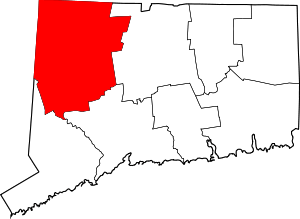 | |
| Towns | ||
| Boroughs | ||
| CDPs | ||
| Other communities | ||
| Indian reservation | ||
| Topics | |||||||
|---|---|---|---|---|---|---|---|
| States | |||||||
| Major cities | |||||||
| State capitals | |||||||
| Transportation |
| ||||||
| |||||||
| Authority control |
|
|---|