Avon, Connecticut
Avon is a town in the Farmington Valley region of Hartford County, Connecticut, United States. As of 2019, the town had a population of 18,302.
Avon, Connecticut | |
|---|---|
 Seal | |
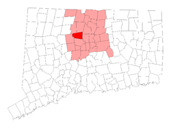 Location within Hartford County, Connecticut | |
 Avon Location in Connecticut  Avon Avon (the United States)  Avon Avon (North America) | |
| Coordinates: 41°47′40″N 72°51′28″W | |
| Country | |
| U.S. state | |
| County | Hartford |
| Metropolitan area | Hartford |
| Settled | 1645 |
| Incorporated | 1830 |
| Villages | Avon West Avon |
| Government | |
| • Type | Council-manager |
| • Town manager | Brandon Robertson |
| • Town council | Heather Maguire (R) Jeff Bernetich (R) David Pena (D) James Speich (R) William Stokesbury (R)[1] |
| Area | |
| • Total | 23.5 sq mi (60.9 km2) |
| • Land | 23.1 sq mi (59.9 km2) |
| • Water | 0.4 sq mi (1.0 km2) |
| Elevation | 276 ft (84 m) |
| Population (2019) | |
| • Total | 18,302 |
| • Density | 781.6/sq mi (288/km2) |
| Time zone | UTC−5 (Eastern) |
| • Summer (DST) | UTC−4 (Eastern) |
| ZIP Code | 06001 |
| Area code(s) | 860/959 |
| FIPS code | 09-02060 |
| GNIS feature ID | 0213385 |
| Major highways | |
| Website | www |
Avon is a suburb of Hartford.
History
Avon was settled in 1645 and was originally a part of Farmington. In 1750, the parish of Northington was established in the northern part of Farmington, to support a Congregational church more accessible to the local population. Its first pastor was Ebenezer Booge, a graduate of Yale Divinity School who arrived in 1751. The Farmington Canal's opening in 1828 brought new business to the village, which sat where the canal intersected the Talcott Mountain Turnpike linking Hartford to Albany, New York. Hopes of industrial and commercial growth spurred Avon to incorporate. In 1830, the Connecticut General Assembly incorporated Northington as the town of Avon, after County Avon in England. Such expansion never came and, in the 1900s, the rural town became a suburban enclave.
In the 1960s Avon rejected the proposal for Interstate 291 coming through the southern edge of the town and successfully denied the expressway going through the town.
Avon Mountain traffic accidents
The section of Talcott Mountain, known as Avon Mountain, between Avon and West Hartford, is known for the climb of U.S. Route 44, and the most direct path to Hartford from much of the Farmington Valley and Litchfield County. One of the worst traffic accidents in Connecticut history occurred at the intersection of Route 44 and Route 10 at the foot of Avon Mountain.
On July 29, 2005, the driver of a dump truck lost control of his brakes and swerved to avoid traffic waiting in his lane at the stoplight. On the eastbound side of the road, the truck then collided with rush hour traffic waiting at the light. Four people, including the driver of the truck, died in the crash. Another driver involved in the accident died in 2008 from complications directly as a result of the crash.[2] Former Governor M. Jodi Rell proposed safety improvements for this road in the aftermath of the accident.[3]
In September 2007, the driver of another truck lost control. The truck, traveling westbound on U.S. Route 44 at Route 10, crashed into the Nassau Furniture building at about 11 am, taking out a column that supports the roof of the building. No major injuries resulted from the crash.[4]
The accidents prompted the State of Connecticut to modify Route 44 through the addition of a runaway truck ramp just above the Avon Old Farms Inn and the straightening and widening of the road on the western slope of the mountain. The accidents and the reconstruction of the road have been heavily covered by local media including the Hartford Courant.
Geography
According to the United States Census Bureau, the town has a total area of 23.5 square miles (61 km2), of which 23.1 square miles (60 km2) is land and 0.4 square miles (1.0 km2) is water.
The East side of Avon is flanked by Talcott Mountain, part of the Metacomet Ridge, a mountainous trap rock ridgeline that stretches from Long Island Sound to near the Vermont border. Talcott Mountain is a popular outdoor recreation resource notable for its towering western cliff faces. The 51-mile (82 km) Metacomet Trail traverses the Talcott Mountain ridge.
Demographics
| Historical population | |||
|---|---|---|---|
| Census | Pop. | %± | |
| 1830 | 1,025 | — | |
| 1840 | 1,001 | −2.3% | |
| 1850 | 995 | −0.6% | |
| 1860 | 1,059 | 6.4% | |
| 1870 | 987 | −6.8% | |
| 1880 | 1,057 | 7.1% | |
| 1890 | 1,182 | 11.8% | |
| 1900 | 1,302 | 10.2% | |
| 1910 | 1,337 | 2.7% | |
| 1920 | 1,534 | 14.7% | |
| 1930 | 1,738 | 13.3% | |
| 1940 | 2,258 | 29.9% | |
| 1950 | 3,171 | 40.4% | |
| 1960 | 5,273 | 66.3% | |
| 1970 | 8,352 | 58.4% | |
| 1980 | 11,201 | 34.1% | |
| 1990 | 13,937 | 24.4% | |
| 2000 | 15,832 | 13.6% | |
| 2010 | 18,098 | 14.3% | |
| Est. 2014 | 18,421 | [5] | 1.8% |
| U.S. Decennial Census[6] | |||
As of 2010, Avon had a population of 18,098. The racial composition of the population was 89.8% white, 1.5% black or African American, 6.3% Asian, 0.7% from other races and 1.7% from two or more races. 3.4% of the population was Hispanic or Latino of any race.[7]
As of the census[8] of 2000, there were 15,832 people, 6,192 households, and 4,483 families residing in the town. The population density was 684.8 people per square mile (264.4/km2). There were 6,480 housing units at an average density of 280.3 per square mile (108.2/km2). The racial makeup of the town was 94.93% White, 0.98% African American, 0.05% Native American, 2.96% Asian, 0.02% Pacific Islander, 0.28% from other races, and 0.77% from two or more races. Hispanic or Latino of any race were 1.57% of the population.
There were 6,192 households, out of which 34.0% had children under the age of 18 living with them, 65.8% were married couples living together, 4.7% had a female householder with no husband present, and 27.6% were non-families. Of all households, 23.5% were made up of individuals, and 9.5% had someone living alone who was 65 years of age or older. The average household size was 2.53 and the average family size was 3.03.
In the town, the population was spread out, with 26.1% under the age of 18, 3.3% from 18 to 24, 26.1% from 25 to 44, 29.5% from 45 to 64, and 15.0% who were 65 years of age or older. The median age was 42 years. For every 100 females, there were 91.8 males. For every 100 females age 18 and over, there were 88.0 males.
The mean income for a household in the town is $155,707, and the mean income for a family is $186,289. Males had a median income of $76,882 versus $44,848 for females. The per capita income for the town was $51,706. About 0.9% of families and 1.7% of the population were below the poverty line, including 1.2% of those under age 18 and 1.9% of those age 65 or over.
Arts and culture
Public library
The Avon Free Public Library can be traced back to 1791 when Rev. Rufus Hawley started collecting money from residents to purchase books for a community library. In 1798, Samuel Bishop, a prominent citizen, began offering library services within his home with a collection of 111 titles.
The library is a member of Library Connection, Inc., the cooperative regional automated circulation and online catalog database system, CONNECT, to which 33 libraries belong. Through this system, over 4 million volumes are available through interlibrary loan, the statewide reciprocal borrowing arrangement which encompasses over 160 libraries.
Notable locations
- Avon Congregational Church built in 1819 and added to the National Register of Historic Places in 1972.
- The Farmington Canal Heritage Trail runs through town.
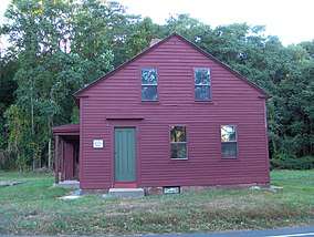
Properties owned by Avon Historical Society
- Derrin House[9] – 18th-century farmhouse
- Living Museum[10] – former schoolhouse
- Pine Grove School House[11] – former schoolhouse
Government
| Voter registration and party enrollment as of October 29, 2019[12] | |||||
|---|---|---|---|---|---|
| Party | Active voters | Inactive voters | Total voters | Percentage | |
| Republican | 3,967 | 207 | 4,174 | 29.59% | |
| Democratic | 4,007 | 222 | 4,229 | 29.98% | |
| Unaffiliated | 5,098 | 441 | 5,539 | 39.26% | |
| Minor parties | 153 | 11 | 164 | 1.16% | |
| Total | 13,225 | 881 | 14,106 | 100% | |
| Presidential Election Results[13] | |||
|---|---|---|---|
| Year | Democratic | Republican | Third Parties |
| 2016 | 53.7% 5,675 | 41.5% 4,390 | 4.8% 502 |
| 2012 | 46.1% 4,830 | 52.9% 5,542 | 1.0% 105 |
| 2008 | 53.5% 5,698 | 45.6% 4,868 | 0.9% 100 |
| 2004 | 48.3% 4,925 | 50.3% 5,141 | 1.4% 148 |
| 2000 | 45.7% 4,326 | 50.0% 4,741 | 4.3% 408 |
| 1996 | 43.5% 3,606 | 48.3% 4,014 | 8.2% 685 |
| 1992 | 44.0% 3,983 | 37.4% 3,390 | 18.6% 1,680 |
| 1988 | 38.2% 3,117 | 60.8% 4,966 | 1.0% 82 |
| 1984 | 30.8% 2,258 | 69.0% 5,063 | 0.2% 13 |
| 1980 | 26.8% 1,815 | 54.8% 3,702 | 18.4% 1,243 |
| 1976 | 34.6% 1,864 | 65.0% 3,498 | 0.4% 23 |
| 1972 | 33.4% 1,585 | 65.9% 3,131 | 0.7% 32 |
| 1968 | 37.5% 1,485 | 58.5% 2,308 | 4.0% 154 |
| 1964 | 56.2% 1,763 | 43.8% 1,374 | 0.00% 0 |
| 1960 | 42.2% 1,185 | 57.8% 1,621 | 0.00% 0 |
| 1956 | 29.0% 663 | 71.0% 1,626 | 0.00% 0 |
Education
Public schools
Avon is home to Avon High School as well as two elementary schools, Pine Grove Elementary and Roaring Brook Elementary, an intermediate (grades 5–6) school, Thompson Brook, and a middle school (grades 7–8), Avon Middle School.[14]
Private schools
- Avon Old Farms School
Notable people
- Will Friedle, actor
- Mike Golic, radio announcer for ESPN
- Jessica Lundy, actor
- Kia McNeill, professional soccer player[15]
- Joel Quenneville former NHL player and coach of the Chicago Blackhawks.
- Karl Ravech, Host of Baseball Tonight
- Stuart Scott, ESPN reporter who covered the NBA and other sports.
- Trey Wingo, ESPN
References
- "Town Council". Official website of Avon, Connecticut. Retrieved June 16, 2018.
- Yardley, William; Stowe, Stacey (July 30, 2005). "Dump Truck Plows Through Intersection, Causing 20-Vehicle Accident and Killing 4". The New York Times. Retrieved April 26, 2010.
- Governor, Office of the. "Governor Rell: Governor Rell Pledges to Build On Road Safety Progress; First Anniversary of Avon Mountain Crash". www.ct.gov. Retrieved June 7, 2018.
- "Archived copy". Archived from the original on September 28, 2011. Retrieved September 12, 2007.CS1 maint: archived copy as title (link)
- "Annual Estimates of the Resident Population for Incorporated Places: April 1, 2010 to July 1, 2014". Archived from the original on May 23, 2015. Retrieved June 4, 2015.
- "Census of Population and Housing". Census.gov. Retrieved June 4, 2015.
- 2010 population by race and Hispanic or Latino by place chart for Connecticut from the US Census.
- "U.S. Census website". United States Census Bureau. Retrieved 2008-01-31.
- "The Derrin House". Avon Historical Society. Archived from the original on July 25, 2011. Retrieved September 15, 2010.
- "Living Museum". Avon Historical Society. Archived from the original on July 25, 2011. Retrieved September 15, 2010.
- "Pine Grove School". Avon Historical Society. Archived from the original on July 25, 2011. Retrieved September 15, 2010.
- "Registration and Party Enrollment Statistics as of October 29, 2019" (PDF). Connecticut Secretary of State. October 29, 2019. Retrieved February 17, 2020.
- "General Election Statements of Vote, 1922 – Current". CT Secretary of State. Retrieved May 6, 2020.
- "Avon Public Schools |". avon.k12.ct.us. Retrieved June 7, 2018.
- Riley, Lori (August 21, 2010). "McNeill Helps Beat To Victory Over Breakers In Women's Soccer". Hartford Courant. Retrieved May 24, 2014.
External links
| Wikivoyage has a travel guide for Avon (Connecticut). |

Municipalities and communities of Hartford County, Connecticut, United States | ||
|---|---|---|
| Cities | 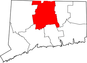 | |
| Towns | ||
| CDPs | ||
| Other communities | ||
| Authority control |
|
|---|